Related Research Articles

Ulster County is a county in the U.S. state of New York. It is situated along the Hudson River. As of the 2020 census, the population was 181,851. The county seat is Kingston. The county is named after the Irish province of Ulster.
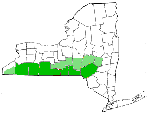
The Southern Tier is a geographic subregion of the broader Upstate region of New York State, geographically situated along or very near the state border with Pennsylvania. Definitions of the region vary widely, but generally encompass counties surrounding the Binghamton and Elmira-Corning metropolitan areas. This region is adjacent to the Northern Tier of Pennsylvania, and both these regions together are known as the Twin Tiers.

High Tor State Park is a 691-acre (2.80 km2) state park on the north edge of the Town of Clarkstown in Rockland County, New York, United States. The park is located on South Mountain, which has two peaks, High Tor and Little Tor. Its highest peak, High Tor, is 797 feet (243 m) high.

Goosepond Mountain State Park, also known as Goose Pond Mountain State Park, is a 1,706-acre (6.90 km2) undeveloped state park located in Orange County, New York. The park is located within the Town of Chester and is administered by the Palisades Interstate Park Commission.

Schodack Island State Park is a 1,052-acre (4.26 km2) state park that spans portions of Rensselaer, Greene, and Columbia counties, New York. The park is located between the Hudson River and Schodack Creek, and was opened in 2002.

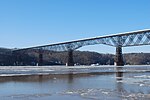
The Walkway over the Hudson is a steel cantilever bridge spanning the Hudson River between Poughkeepsie, New York, on the east bank and Highland, New York, on the west bank. Built as a double track railroad bridge, it was completed on January 1, 1889, and formed part of the Maybrook Railroad Line of the New York, New Haven and Hartford Railroad.
Taconic State Park is located in Columbia and Dutchess County, New York abutting Massachusetts and Connecticut within the Taconic Mountains. The state park is located off New York State Route 344 south of Interstate 90 and 110 miles (180 km) north of New York City. It features camping, hiking, bicycling, hunting, cross county skiing and other recreational opportunities.

The Genesee Valley Greenway is a rail trail in western New York's Genesee River valley.

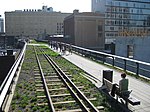
The Wallkill Valley Rail Trail is a 23.7-mile (38.1 km) rail trail and linear park that runs along the former Wallkill Valley Railroad rail corridor in Ulster County, New York, United States. It stretches from Gardiner through New Paltz, Rosendale and Ulster to the Kingston city line, just south of a demolished, concrete Conrail railroad bridge that was located on a team-track siding several blocks south of the also-demolished Kingston New York Central Railroad passenger station. The trail is separated from the Walden–Wallkill Rail Trail by two state prisons in Shawangunk, though there have been plans to bypass these facilities and to connect the Wallkill Valley Rail Trail with other regional rail-trails. The northern section of the trail forms part of the Empire State Trail.

A linear park is a type of park that is significantly longer than it is wide. These linear parks are strips of public land running along canals, rivers, streams, defensive walls, electrical lines, or highways and shorelines. Examples of linear parks include everything from wildlife corridors to riverways to trails, capturing the broadest sense of the word. Other examples include rail trails, which are disused railroad beds converted for recreational use by removing existing structures. Commonly, these linear parks result from the public and private sectors acting on the dense urban need for open green space. Linear parks stretch through urban areas, coming through as a solution for the lack of space and need for urban greenery. They also effectively connect different neighborhoods in dense urban areas as a result, and create places that are ideal for activities such as jogging or walking. Linear parks may also be categorized as greenways. In Australia, a linear park along the coast is known as a foreshoreway. When being designed, linear parks appear unique as they are planned around the public's opinion of how the space will affect them.

The Dutchess Rail Trail is a 13-mile (21 km) rail trail that stretches from the former Hopewell Junction train depot, north to the Poughkeepsie entrance of the Walkway over the Hudson. It's a shared use rail trail open for pedestrians and bicyclers. The Dutchess Rail Trail forms part of the Empire State Trail.

The Selkirk Hurdle is the term used by urban planners, railroad employees, politicians, and others to describe the route that must be taken by freight trains traveling between New York City and other points in downstate New York that are east of the Hudson River, and locations in the United States to the south and west. There are no rail freight bridges or tunnels that cross the Hudson River south of Selkirk, which is 10 miles (16 km) south of Albany and the home of Selkirk Yard, a major CSX classification yard. As a result, trains from Long Island and New York City must travel 140 miles (230 km) north to cross at Selkirk before continuing on their way. Advocates claim that this detour and the inefficiencies that result force New York City to rely more heavily on relatively-inefficient trucks than most parts of the United States, where freight trains are more common. However, at least for traffic to and from the west, this route was touted for its efficiency as the "Water Level Route" by the New York Central Railroad because trains using it did not have to climb over the Appalachian Mountains, and it is still used by the New York Central's successor, CSX, for traffic to both sides of the Hudson River.
The Mohawk-Hudson Bike-Hike Trail (MHBHT) is a 97-mile (156 km) trail in New York's Mohawk Valley and Capital District regions. It is also the easternmost segment of the Erie Canalway Trail, as well as a portion of the Empire State Trail.


The Hudson Valley Rail Trail is a paved 4-mile (6.4 km) east–west rail trail in the town of Lloyd in Ulster County, New York, stretching from the Hudson River through the hamlet of Highland. The trail was originally part of the Poughkeepsie Bridge Route, a rail corridor that crossed the Hudson via the Poughkeepsie Bridge. Controlled by a variety of railroads throughout the 19th and 20th centuries, the bridge was damaged and became unusable after a May 8, 1974 fire. By the 1980s, the corridor's then-owner, Conrail, had routed all rail traffic in the region north through Selkirk Yard and was eager to relieve itself of the bridge and adjoining rights-of-way. In 1984, it sold the entire property for one dollar to a felon who did not maintain it or pay taxes on it. The section of the corridor west of the Hudson was seized by Ulster County in 1991 and transferred to the town of Lloyd.

The Rosendale Trestle is a 940-foot (290-meter) continuous truss bridge and former railroad trestle in Rosendale Village, a hamlet in the town of Rosendale in Ulster County, New York. Originally constructed by the Wallkill Valley Railroad to continue its rail line from New Paltz to Kingston, the bridge rises 150 ft (46 m) above Rondout Creek, spanning both Route 213 and the former Delaware and Hudson Canal. Construction on the trestle began in late 1870, and continued until early 1872. When it opened to rail traffic on April 6, 1872, the Rosendale trestle was the highest span bridge in the United States.

Franny Reese State Park is a 251-acre (1.02 km2) state park located in the Town of Lloyd in Ulster County, New York. The park is managed by Scenic Hudson and is part of the Palisades Interstate Park system.
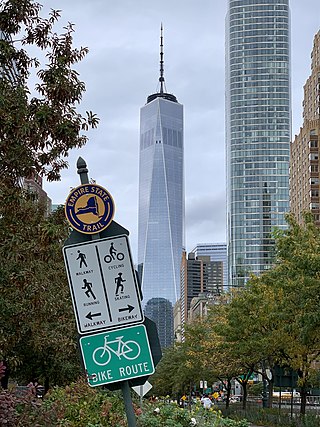
The Empire State Trail is a multi-use trail in New York State that was proposed by Governor Andrew Cuomo in January 2017 and completed in December 2020. The trail runs from Manhattan north to the Canada–United States border in Rouses Point near the northern tip of Lake Champlain, and also from Buffalo to Albany. At 750 miles (1,210 km), it is the longest multi-use trail in the United States. The trail includes pre-existing trail segments, which retain their existing identity but are now co-signed as a segment of the Empire State Trail. The trail also links to other regional bicycling and hiking trails such as the Appalachian Trail, the Adirondack and Catskill Parks, the Great Lakes Seaway Trail, the Genesee Valley Greenway, and others. A segment near its southernmost part, on the Hudson River Greenway in Manhattan, is concurrent with the East Coast Greenway. The trail is used for hiking, biking, snowshoeing, cross-country skiing and in some areas snowmobiling.
References
- ↑ Clarence Pathways (TrailLink)
- ↑ "Section of Albany County Rail Trail to Open June 2". Albany County. Retrieved 2011-05-31.
- ↑ "Allegheny River Valley Trail - Town of Allegany". Town of Allegany. Retrieved 2011-01-12.
- ↑ Catherine Valley Trail (TrailLink)
- ↑ Parks and Facilities. "Rails To Trails". Town of Cheektowaga, New York.
- ↑ Corning Bike Path (AllTrails.com)
- ↑ 1955 Topographical Map of Corning, New York (Historic Aerials)
- ↑ Gorge Trail (TrailLink)
- ↑ Parks and Recreation. "Greater Jamestown Riverwalk". City of Jamestown, New York.
- ↑ http://www.gcswcd.com/images/stories/KRT/KRTmaps-combined_5%2014%2013.pdf [ bare URL PDF ]
- ↑ "About the Rail Trail". Hudson Valley Rail Trail Association. Retrieved 2011-01-11.
- ↑ Jim Schug Trail (Town of Dryden, New York)
- ↑ John Kieran Nature Trail (TrailLink)
- ↑ http://www.gcswcd.com/images/stories/KRT/KRTmaps-combined_5%2014%2013.pdf [ bare URL PDF ]
- ↑ Lehigh Memory Trail (TrailLink)
- ↑ Sodus-Wallington Rail Trail (TrailLink)
- ↑ Hiking the Trail to Yesterday; The Edwards Nature Trail
- ↑ "Park Description and Program Schedules" (PDF). Walden, NY: Village of Walden Recreation and Parks. Archived from the original (PDF) on 2010-12-26. Retrieved 2010-12-26.
- ↑ "Fast Facts About the Walkway". Walkway Over the Hudson. Retrieved 2010-11-24.
- ↑ "Wallkill Valley Rail Trail Length Doubles". Open Space Institute. 2009-08-31. Retrieved 2010-11-01.
- ↑ "Visit Lake George; Bicycling". Lake George Area in New York's Adirondacks. Retrieved 2013-04-11.