Ulster County, New York

Last updated

Ulster County
Mohonk Mountain House 2011 View of Mohonk Guest Rooms from One Hiking Trail FRD 3205.jpg
Flag of Ulster County, New York.svg
Seal of Ulster County, New York.png
Map of New York highlighting Ulster County.svg
Location within the U.S. state of New York
New York in United States.svg
New York's location within the U.S.
Coordinates: 41°53′N74°16′W / 41.89°N 74.26°W / 41.89; -74.26
CountryFlag of the United States.svg United States
StateFlag of New York.svg  New York
FoundedNovember 1, 1683;340 years ago (1683-11-01) [upper-alpha 1]
Named for Prince James, Duke of York and Albany and Earl of Ulster
Seat Kingston
Largest cityKingston
Government
  County Executive Jen Metzger (D)
Area
  Total1,161 sq mi (3,010 km2)
  Land1,124 sq mi (2,910 km2)
  Water37 sq mi (100 km2)  3.1%
Population
 (2020)
  Total181,851 Decrease2.svg
  Density160/sq mi (60/km2)
Time zone UTC−5 (Eastern)
  Summer (DST) UTC−4 (EDT)
Congressional districts 18th, 19th
Website ulstercountyny.gov

Ulster County is a county in the U.S. state of New York. It is situated along the Hudson River. As of the 2020 census, the population was 181,851. [1] The county seat is Kingston. [2] The county is named after the Irish province of Ulster. The county is part of the Hudson Valley region of the state.

Contents

History

Ulster County in 1875 Beers Ulster County Atlas Page018-019.jpg
Ulster County in 1875

Founding and formation

When part of the New Netherland colony, Dutch traders first called the area of present-day Ulster County "Esopus", a name borrowed for convenience from a locality on the opposite side of the Hudson. "Esopus" meant "land of flowing water and high banks," or "small brook." [3] [4] There is also a town named Esopus located within Ulster County.

The local Lenape indigenous people called themselves Waranawanka, but soon came to be known to the Dutch as the "Esopus Indians" because they were encountered around the settlement known as Esopus. In 1652, Thomas Chambers, a freeholder from the Manor of Rensselaerswyck, purchased land at Esopus. [5] He and several others actually settled and began farming by June 1653. The settlements grew into the village of Wiltwijck, which the English later named Kingston. In 1683, the Duke of York created 12 counties in his province, one of which was Ulster County, named after Prince James, Duke of York (later King James II of England) whose subsidiary titles included Earl of Ulster. Its boundaries at that time included the present Sullivan County and parts of the present Delaware, Orange, and Greene Counties. [upper-alpha 1]

In 1777, the first state capital of the independent New York State was established at Kingston. The official records of Ulster County were removed to safety to a stone house in Kerhonkson when it became evident that the British would burn Kingston.

In 1797, parts of Otsego and Ulster Counties were split off to create Delaware County. [upper-alpha 1]

In 1798, Ulster County's southernmost towns were moved into Orange County to compensate Orange for breaking away its southernmost part to form Rockland County.

In 1800, portions of Albany and Ulster Counties were split off to create Greene County. [upper-alpha 1]

In 1809, Sullivan County was split off from Ulster County. [upper-alpha 1]

Civil War

During the American Civil War, volunteers were recruited from the county and formed the majority of the following regiments:

Other regiments with at least one company from the county included:

Twentieth century

The Lake Mohonk Mountain House on Shawangunk Ridge was designated a National Historic Landmark in 1986. [6]

Geography

Lake Minnewaska Lake Minnewaska Minnewaska State Park Preserve.jpg
Lake Minnewaska

According to the U.S. Census Bureau, the county has an area of 1,161 square miles (3,010 km2), of which 1,124 square miles (2,910 km2) is land and 37 square miles (96 km2) (3.1%) is water. [7]

Ulster County is in southeastern New York State, south of Albany, immediately west of the Hudson River. Much of it is within the Catskill Mountains and the Shawangunk Ridge. Ulster County has Minnewaska State Park Preserve, Mohonk Preserve, Sundown State Park, VerNooykill State Forest, Witches Hole State Forest, and Shawangunk Ridge State Forest. The Sam's Point section of Minnewaska includes rare dwarf pine trees and Verkeerder Kill falls.

The county's highest point is Slide Mountain, at approximately 4,180 feet (1,270 m) above sea level. The lowest point is sea level along the Hudson River.

Adjacent counties

National protected area

Demographics

Historical population
CensusPop.Note
1790 29,370
1800 24,855−15.4%
1810 26,5766.9%
1820 30,93416.4%
1830 36,55018.2%
1840 45,82225.4%
1850 59,38429.6%
1860 76,38128.6%
1870 84,07510.1%
1880 85,8382.1%
1890 87,0621.4%
1900 88,4221.6%
1910 91,7693.8%
1920 74,979−18.3%
1930 80,1556.9%
1940 87,0178.6%
1950 92,6216.4%
1960 118,80428.3%
1970 141,24118.9%
1980 158,15812.0%
1990 165,3044.5%
2000 177,7497.5%
2010 182,4932.7%
2020 181,851−0.4%
U.S. Decennial Census [8]
1790–1960 [9] 1900–1990 [10]
1990–2000 [11] 2010–2020 [1]

As of the census [12] of 2010, the county had 181,440 people, 67,499 households, and 43,536 families. The population density was 158 inhabitants per square mile (61/km2). There were 77,656 housing units at an average density of 69 units per square mile (27/km2). The county's racial makeup, as of 2008, was 83.2% white, 6.50% black or African American, 0.3% Native American, 1.7% Asian, 0.03% Pacific Islander, 2.15% from other races, and 1.70% from two or more races. 7.6% of the population were Hispanic or Latino of any race. 19.2% were of Italian, 16.8% Irish, 15.5% German, 6.8% English, and 4.7% American ancestry according to Census 2000. 90.3% spoke English, 4.5% Spanish, 1.2% Italian, and 1.0% German as their first language.

There were 67,499 households, of which 30.70% had children under age 18 living with them, 49.20% were married couples living together, 10.90% had a female householder with no husband present, and 35.50% were non-families. Of all households, 27.90% were made up of individuals, and 10.20% had someone living alone who was 65 years of age or older. The average household size was 2.47 and the average family size was 3.03.

23.50% of the county's population was under age 18, 8.70% was from age 18 to 24, 29.70% was from age 25 to 44, 24.70% was from age 45 to 64, and 13.30% was age 65 or older. The median age was 38 years. For every 100 females, there were 99.10 males. For every 100 females age 18 and over, there were 96.60 males.

The county's median household income was $42,551, and the median family income was $51,708. Males had a median income of $36,808 versus $27,086 for females. The per capita income for the county was $20,846. About 7.20% of families and 11.40% of the population were below the poverty line, including 13.00% of those under age 18 and 8.70% of those age 65 or over.

2020 Census

As of the 2020 census the population of Ulster County is 181,851. The population density was 158 inhabitants per square mile (61/km2). The county's racial makeup, as of 2020, was 75.16% non-Hispanic white, 5.8% black or African American, 0.2% Native American, 2.1% Asian, 0.02% Pacific Islander, 5.4% from other races or from two or more races. 11.61% of the population were Hispanic or Latino of any race

Ulster County Racial Composition [13]
RaceNum.Perc.
White (NH)136,69575.16%
Black or African American (NH)10,1525.8%
Native American (NH)3060.2%
Asian (NH)3,7782.1%
Pacific Islander (NH)450.02%
Other/Mixed (NH)9,7565.4%
Hispanic or Latino 21,11911.61%

Government and politics

United States presidential election results for Ulster County, New York [14]
Year Republican Democratic Third party
No.%No.%No.%
2020 37,59038.59%57,97059.51%1,8601.91%
2016 35,23941.32%44,59752.29%5,4546.39%
2012 29,75937.37%47,75259.97%2,1152.66%
2008 33,30037.35%54,32060.93%1,5291.72%
2004 37,82143.12%47,60254.27%2,2892.61%
2000 33,44742.75%38,16248.78%6,6288.47%
1996 26,21235.49%35,85248.55%11,78715.96%
1992 29,22336.16%32,88640.69%18,71223.15%
1988 41,17356.75%30,74442.37%6400.88%
1984 47,37263.93%26,44535.69%2850.38%
1980 36,70955.01%22,17933.24%7,83811.75%
1976 35,35353.44%30,19045.64%6100.92%
1972 46,88368.51%21,37131.23%1790.26%
1968 34,79857.62%20,88634.59%4,7037.79%
1964 23,74940.03%35,48659.82%910.15%
1960 36,41861.20%23,01738.68%670.11%
1956 43,03476.36%13,32123.64%00.00%
1952 36,14169.44%15,73330.23%1710.33%
1948 28,94164.30%14,44132.08%1,6303.62%
1944 26,70361.02%16,94338.72%1170.27%
1940 27,18657.00%20,40342.78%1070.22%
1936 24,67855.32%19,11842.85%8151.83%
1932 21,00252.87%18,09245.55%6271.58%
1928 25,41862.46%14,20034.89%1,0772.65%
1924 20,04863.32%9,36129.57%2,2517.11%
1920 19,00166.41%8,75930.61%8522.98%
1916 10,73456.58%7,80741.15%4302.27%
1912 7,48538.33%8,51043.58%3,53118.08%
1908 10,47553.06%8,56043.36%7053.57%
1904 11,35653.13%9,51644.52%5012.34%
1900 11,34853.68%9,34944.22%4442.10%
1896 11,10056.31%8,14041.30%4712.39%
1892 9,45046.29%9,80848.04%1,1575.67%
1888 10,82549.57%10,48748.02%5262.41%
1884 9,92948.71%9,87048.42%5862.87%

For most of the 20th century, Ulster County voted for the Republican nominees for president. Republicans regularly got over 60% of the vote, the high point coming when Dwight D. Eisenhower won 76% in 1956. The Democratic nominee won only in 1912, when Theodore Roosevelt and his Progressive Party split the Republican vote and gave a plurality to Woodrow Wilson, and in 1964, when Lyndon B. Johnson won every county in New York and carried Ulster County by 19.8 percentage points.

More recently, Ulster County has voted Democratic. In 1992, 1996, and 2000, the party won a plurality, due to strong showings from third parties. In 2004, John Kerry defeated George W. Bush, 54%–43%; in 2008, Barack Obama defeated John McCain, 61%–37%; in 2012, Obama defeated Mitt Romney, 60%–37%; in 2016, Hillary Clinton defeated Donald Trump, 52%–41%; and in 2020, Joe Biden defeated Trump, 60%–39%.

As of 2023, most of the county is in New York's 18th congressional district, represented by Democrat Pat Ryan. Some of the west and north of the county is in New York's 19th congressional district, represented by Republican Marc Molinaro. It had no U.S. representative after Antonio Delgado resigned on May 25, 2022, to become lieutenant governor of New York. Ryan won a special election on August 23 against Molinaro, and was sworn in on September 13. Ryan ran in the 18th congressional district in the 2022 general election after redistricting put most of Ulster County in that district. Ryan was narrowly reelected against New York Assembly member Colin Schmitt. Molinaro ran in the 19th district and narrowly defeated Democrat Josh Riley.

County government

For a long time, Ulster County had a county-scale version of a council-manager government, with the county legislature hiring a county administrator to handle executive functions. The chair of the legislature had a great deal of power and was accountable only to the voters of their district. The only countywide elected officials were the county clerk (Nina Postupack has served since 2005), district attorney (Emmanuel "Manny" Nneji took office in 2024) and sheriff (Juan Figueroa took office in 2019).

In 2006, voters approved the first-ever county charter, changing to an elected executive branch. Two years later, Michael P. Hein, the last appointed county administrator, became Ulster's first elected county executive. [15] In early 2019, Hein resigned to accept Governor Andrew Cuomo's appointment as commissioner of the state Office of Temporary and Disability Assistance. [16] Deputy County Executive Adele Reiter succeeded him as acting county executive until a special election was held in April 2019.

On April 30, 2019, Democrat Patrick K. Ryan was elected in a special election by a margin of 74%-26%. [17] He was sworn in as Ulster County's second County Executive on June 7, 2019. [18] On September 9, 2022, Ryan stepped down as county executive after winning election to the United States House of Representatives, and Johanna Contreras was sworn in as an acting county executive. [19]

Democrat Jen Metzger, a former New York State Senator, defeated Republican Jim Quigley in the 2022 election to replace Ryan. [20] Metzger took office in 2023.

Ulster County Executives
NamePartyTerm
Michael P. Hein Democratic January 1, 2009 – February 11, 2019
Adele Reiter Democratic February 11, 2019 – June 7, 2019 (Acting)
Pat Ryan Democratic June 7, 2019 – September 9, 2022
Johanna Contreras Democratic September 9, 2022 – December 31, 2022 (Acting)
Jen Metzger Democratic January 1, 2023 – Present
Other Current Countywide Elected Officials in Ulster County
OfficeNamePartyTerm
County ComptrollerMarch Gallagher Democratic January 1, 2020 – Present
County SheriffJuan Figueroa Democratic January 1, 2019 – Present
District AttorneyEmmanuel "Manny" Nneji Democratic January 1, 2024 – Present
County ClerkNina Postupack Republican September 15, 2005 – December 31, 2005 (Acting)

January 1, 2006 – Present

Legislative authority is vested in the County Legislature, which consists of 23 members elected from individual districts, as directed by a county charter reapportionment mandate starting in late 2010. [21] Of the members of the County Legislature, 15 are part of the Democratic Caucus (all 15 are affiliated with the Democratic Party), and 8 are part of the Republican Caucus (all 8 are affiliated with the Republican Party).

Ulster County Legislature (2024-2025)
DistrictLegislator Party CaucusResidence
Aaron Levine, Deputy Majority Leader DemocraticDemocratic Saugerties
Joe MaloneyDemocraticDemocratic Saugerties
Jason KovacsRepublicanRepublican Ulster
Eric KitchenRepublicanRepublican Ulster
Abe Uchitelle, Majority Leader DemocraticDemocratic Kingston
Greg McCoulloughDemocraticDemocratic Kingston
Peter Criswell, Chair DemocraticDemocratic Kingston
Joe DonaldsonDemocraticDemocratic Port Ewen
Herbert Litts IIIRepublicanRepublican Highland
Gina HansutRepublicanRepublican Highland
Thomas Corcoran, Jr.RepublicanRepublican Marlborough
Kevin Roberts, Minority Leader RepublicanRepublican Plattekill
Richard WallsRepublicanRepublican Wallkill
Craig Lopez, Deputy Minority Leader RepublicanRepublican Pine Bush
John GavarisDemocraticDemocratic Ellenville
Debra ClintonDemocraticDemocratic Gardiner
Megan Sperry, Vice Chair DemocraticDemocratic Rifton
Eric StewartDemocraticDemocratic Accord
Manna Jo GreeneDemocraticDemocratic Cottekill
Limina Grace HarmonDemocraticDemocratic New Paltz
Chris HewittDemocraticDemocratic Kerhonkson
Kathy NolanDemocraticDemocratic Mount Tremper
Jeff CollinsDemocraticDemocratic Woodstock

    Recreation

    Ashokan Reservoir from Wittenberg Ashokan Reservoir from Wittenberg.jpg
    Ashokan Reservoir from Wittenberg
    A cow at the Ulster County Fair Cow at Ulster County Fair.JPG
    A cow at the Ulster County Fair

    Ulster County contains a large part of Catskill Park and the Catskill Forest Preserve. The former Delaware and Hudson Canal brought Pennsylvania coal to Kingston on the Hudson. Former Orleans band member John Hall served in the Ulster County legislature before moving to the 19th Congressional District to run for Congress.

    Ulster County has continued to be a popular vacation destination for many decades. The county is home to many outdoor landscapes, including the Catskill Mountains, the Hudson River, Minnewaska State Park, Catskill Park, Shawangunk Mountains and the Shawangunk Ridge. Each offers various recreation opportunities, including hiking, bicycling, skiing, horseback riding, kayaking, rock climbing, hunting and fishing.

    The county also includes more than 40 miles (64 km) of rail trails along the Hudson Valley Rail Trail, Wallkill Valley Rail Trail, and O&W Rail Trail. The Walkway Over the Hudson, the world's longest pedestrian and bicycle bridge which spans the Hudson River, is connected within Ulster County trails. [22]

    Ulster County has also played a role in some significant moments in U.S. history. The Senate House State Historic Site in Kingston, New York, is where, in early 1777, American colonists met to ratify the New York Constitution.

    The Ulster County Fair has been held in New Paltz for many years and is promoted as "The Best Six Days of Summer". County run recreation areas include the Ulster County Pool in New Paltz and the Ulster Landing Park in Saugerties.

    Since 2016, Kingston Stockade FC, a semi-professional soccer team that plays in the National Premier Soccer League (NPSL), has been based in Kingston and plays its home matches at Dietz Stadium. [23]

    Also since 2015, the Saugerties Stallions, a collegiate summer baseball league team that plays in the Perfect Game Collegiate Baseball League (PGCBL), have been based in Saugerties and play their home games at Cantine Field. The Stallions won the 2021 PGCBL Championship. [24]

    Transportation

    A shield assembly of NY 55, US 44, and US 9W after the Mid-Hudson Bridge 44 NY 55.jpg
    A shield assembly of NY 55, US 44, and US 9W after the Mid-Hudson Bridge

    Public transportation in Ulster County is provided by Trailways of New York to and from New York City and Albany, and along Routes 28 and 32, by Ulster County Area Transit on major state and U.S. road corridors in the county.

    Major roadways

    The New York State Thruway (I-87) runs north–south through the county, carrying traffic between New York City and Albany and its surroundings. NY 55, NY 52, and NY 28 are all major east–west highways that run through the county, and US 209, US 9W, and NY 32 are major north–south highways.

    Communities

    Ulster County, New York

    City

    Towns

    Villages

    Census-designated places

    Hamlets

    See also

    Notes

    1. 1 2 3 4 5 "The county is one of the original divisions of the State, erected November 1, 1683. Of its great territory it has given in the formation of Delaware in 1797, part of Greene in 1800, Sullivan in 1809, and a piece to Orange in the same year." [upper-alpha 2]
    2. Sullivan 1927, p.  437.

    Related Research Articles

    <span class="mw-page-title-main">Ellenville, New York</span> Village in New York, United States

    Ellenville is a village within the town of Wawarsing, Ulster County, New York, United States. Its population was 4,167 at the 2020 census.

    <span class="mw-page-title-main">Esopus, New York</span> Town in New York, United States

    Esopus is a town in Ulster County, New York, United States. The population was 9,548 at the 2020 census. The town was named after the local indigenous tribe and means "small river" in English. They were one of the Lenape (Delaware) bands, belonging to a people who ranged from western Connecticut through lower New York, western Long Island, and parts of New Jersey and Pennsylvania along the Delaware River. The town is on the west bank of the Hudson River south of the city of Kingston. Its center is in Port Ewen. US Route 9W passes along the eastern side of the town.

    <span class="mw-page-title-main">Ulster, New York</span> Town in New York, United States

    Ulster is a town in Ulster County, New York, United States. The population was 12,660 at the 2020 census.

    <span class="mw-page-title-main">Shawangunk Ridge</span> Ridge of bedrock in the state of New York

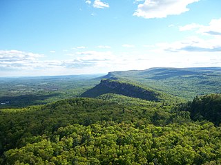
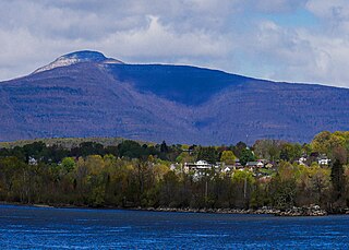
    The Shawangunk Ridge, also known as the Shawangunk Mountains or The Gunks, is a ridge of bedrock in Ulster County, Sullivan County and Orange County in the state of New York, extending from the northernmost point of the border with New Jersey to the Catskills. The Shawangunk Ridge is a continuation of the long, easternmost section of the Appalachian Mountains; the ridge is known as Kittatinny Mountain in New Jersey, and as Blue Mountain as it continues through Pennsylvania. This ridge constitutes the western border of the Great Appalachian Valley.

    <span class="mw-page-title-main">Rondout Creek</span> River in New York, United States

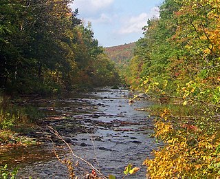
    Rondout Creek is a 63.3-mile-long (101.9 km) tributary of the Hudson River in Ulster and Sullivan counties, New York, United States. It rises on Rocky Mountain in the eastern Catskills, flows south into Rondout Reservoir, part of New York City's water supply network, then into the valley between the Catskills and the Shawangunk Ridge, where it goes over High Falls and finally out to the Hudson at Kingston, receiving along the way the Wallkill River.

    <span class="mw-page-title-main">New York State Route 208</span> Highway in southern New York state, U.S.

    New York State Route 208 (NY 208) is a state highway located in southern New York in the United States. The southern terminus is at an intersection with NY 17M in the Orange County village of Monroe. Its northern terminus is located at an intersection with NY 32 and NY 299 in the Ulster County village of New Paltz.

    <span class="mw-page-title-main">Esopus Creek</span> Tributary of the Hudson River in the Catskill region of New York state

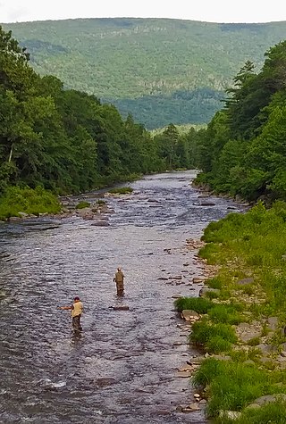
    Esopus Creek is a 65.4-mile-long (105.3 km) tributary of the Hudson River that drains the east-central Catskill Mountains in the U.S. state of New York. From its source at Winnisook Lake on the slopes of Slide Mountain, the Catskills' highest peak, it flows across Ulster County to the Hudson at Saugerties. Many tributaries extend its watershed into neighboring Greene County and a small portion of Delaware County. Midway along its length, it is impounded at Olive Bridge to create Ashokan Reservoir, the first of several built in the Catskills as part of New York City's water supply system. Its own flow is supplemented 13 miles (21 km) above the reservoir by the Shandaken Tunnel, which carries water from the city's Schoharie Reservoir into the creek.

    <span class="mw-page-title-main">New York State Route 212</span> State highway in Ulster County, New York, US

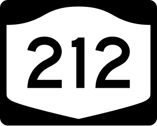
    New York State Route 212 (NY 212) is an east–west state highway located entirely within Ulster County, New York, in the United States. It runs for 21.92 miles (35.28 km) from an intersection with NY 28 in the interior of the Catskill Park to a junction with U.S. Route 9W (US 9W) and NY 32 on the west bank of the Hudson River, providing a key interchange with the New York State Thruway along the way. The mostly rural two-lane route serves the communities of Woodstock and Saugerties while passing Cooper Lake, Kingston's reservoir. NY 212 was assigned as part of the 1930 renumbering of state highways in New York.

    Snyder's Regiment of Militia was known officially as The First Regiment of Ulster County Militia. It was the first regiment of four created in Ulster County, New York as ordered by the Provincial Congress of New York. It was also referred to as the Northern Regiment since its members were from the Northern section of Ulster County towns including Kingston, New York and Saugerties, New York

    <span class="mw-page-title-main">Wallkill Valley Rail Trail</span> Rail Trail in the Wallkill Valley

    The Wallkill Valley Rail Trail is a 23.7-mile (38.1 km) rail trail and linear park that runs along the former Wallkill Valley Railroad rail corridor in Ulster County, New York, United States. It stretches from Gardiner through New Paltz, Rosendale and Ulster to the Kingston city line, just south of a demolished, concrete Conrail railroad bridge that was located on a team-track siding several blocks south of the also-demolished Kingston New York Central Railroad passenger station. The trail is separated from the Walden–Wallkill Rail Trail by two state prisons in Shawangunk, though there have been plans to bypass these facilities and to connect the Wallkill Valley Rail Trail with other regional rail-trails. The northern section of the trail forms part of the Empire State Trail.

    <span class="mw-page-title-main">Esopus people</span>

    The Esopus was a tribe of Lenape (Delaware) Native Americans who were native to the Catskill Mountains of what is now Upstate New York. Their lands included modern-day Ulster and Sullivan counties.

    <span class="mw-page-title-main">Trapps Mountain Hamlet Historic District</span> Historic district in New York, United States

    The Trapps Mountain Hamlet Historic District is located on the Shawangunk Ridge in Gardiner, New York, United States. It is a large area that covers the site of a settlement that thrived there from the late 18th to mid-20th centuries. Inhabitants practiced subsistence farming, making it one of the rare such communities in the East to have left any trace remaining. They supplemented that with a variety of other trades, primarily in the forest products industry, with most inhabitants gradually coming to work at nearby mountain resorts in the 20th century. The last resident died in 1956.

    <span class="mw-page-title-main">Hurley, New York</span> Town in New York, United States

    Hurley is a town in Ulster County, New York, United States. The population was 6,178 at the 2020 census. The town is in the northeastern part of the county, west of the city of Kingston. Much of the town is inside the Catskill Park. Located within the town is a hamlet and census-designated place, also named Hurley. The Town of Hurley comprises the hamlets of Hurley, West Hurley and Glenford.

    <span class="mw-page-title-main">Kingston (town), New York</span> Town in Ulster County, New York, US

    Kingston is a town in Ulster County, New York, United States. The Town of Kingston is in the northeastern part of Ulster County, north of the City of Kingston. Kingston is inside the Catskill Park. The population was 933 at the 2020 census.

    <span class="mw-page-title-main">Kingston, New York</span> County seat of Ulster County, New York, US

    Kingston is the only city in, and the county seat of, Ulster County, New York, United States. It is 91 miles (146 km) north of New York City and 59 miles (95 km) south of Albany. The city's metropolitan area is grouped with the New York metropolitan area around Manhattan by the United States Census Bureau. The population was 24,069 at the 2020 United States Census.

    <span class="mw-page-title-main">New Paltz (village), New York</span> Village in New York

    New Paltz is a village in Ulster County located in the U.S. state of New York. It is approximately 80 miles (130 km) north of New York City and 70 miles (110 km) south of Albany. The population was 7,324 at the 2020 census.

    <span class="mw-page-title-main">New Paltz, New York</span> Town in the United States

    New Paltz is an incorporated U.S. town in Ulster County, New York. The population was 14,407 at the 2020 census. The town is located in the southeastern part of the county and is south of Kingston. New Paltz contains a village, also with the name New Paltz. The town is named for Palz, the dialect name of the Palatinate, called Pfalz in standard German.

    <span class="mw-page-title-main">Saugerties (village), New York</span> Village in Ulster County, New York, United States

    Saugerties is a village in Ulster County, New York, United States. The population was 3,899 at the 2020 census, showing a slight decline from the 3,971 counted at the 2010 census.

    <span class="mw-page-title-main">Saugerties, New York</span> Town in Ulster County, New York, United States

    Saugerties is a town in the northeastern corner of Ulster County, New York. The population was 19,038 at the time of the 2020 Census, a decline from 19,482 in 2010. The village of the same name is located entirely within the town.

    Michael P. Hein is an American politician who served as the 1st County Executive of Ulster County, serving until February 10, 2019 after having first been elected on November 4, 2008. Prior to the creation of this position, the 2008 ratification by referendum of the Ulster County Charter, he was the Ulster County Administrator.

    References

    1. 1 2 "U.S. Census Bureau QuickFacts: Ulster County, New York". United States Census Bureau. Retrieved January 2, 2022.
    2. "Find a County". National Association of Counties. Retrieved June 7, 2011.
    3. "Esopus". Catskill Fly Fishing Museum. Retrieved November 25, 2023.
    4. "Timeline | Klyne Esopus Historical Society Museum". Klyne Esopus Museum. Retrieved November 25, 2023.
    5. "Ulster County, NY - History & Nostalgia Gallery". Hudson Valley Sojourner. Retrieved November 25, 2023.
    6. "National Historic Landmarks Program – Lake Mohonk Mountain House". National Park Service. Archived from the original on November 10, 2013. Retrieved December 7, 2013.
    7. "2010 Census Gazetteer Files". United States Census Bureau. August 22, 2012. Archived from the original on May 19, 2014. Retrieved January 8, 2015.
    8. "U.S. Decennial Census". United States Census Bureau. Retrieved January 8, 2015.
    9. "Historical Census Browser". University of Virginia Library. Retrieved January 8, 2015.
    10. "Population of Counties by Decennial Census: 1900 to 1990". United States Census Bureau. Retrieved January 8, 2015.
    11. "Census 2000 PHC-T-4. Ranking Tables for Counties: 1990 and 2000" (PDF). United States Census Bureau. Retrieved January 8, 2015.
    12. "U.S. Census website". United States Census Bureau . Retrieved January 31, 2008.
    13. "P2 HISPANIC OR LATINO, AND NOT HISPANIC OR LATINO BY RACE – 2020: DEC Redistricting Data (PL 94-171) – Ulster County, New York".
    14. Leip, David. "Dave Leip's Atlas of U.S. Presidential Elections". uselectionatlas.org.
    15. Brooks, Paul (November 5, 2008). "Hein wins big as first Ulster County executive". Times-Herald Record . Ottaway Community Newspapers. Archived from the original on June 17, 2011. Retrieved November 21, 2008.
    16. Doxsey, Patricia (January 4, 2019). "Ulster County Executive Michael Hein leaving to take state post". Daily Freeman. Retrieved February 28, 2020.
    17. Doxsey, Patricia (April 30, 2019). "Democrat Ryan coasts to victory in Ulster County executive special election". Daily Freeman. Retrieved February 28, 2020.
    18. Doxsey, Patricia (June 7, 2019). "Ryan sworn in as Ulster County executive, promises to lead with 'bold vision'". Daily Freeman. Retrieved February 28, 2020.
    19. "Congressman-elect Pat Ryan resigns as Ulster County executive; Contreras sworn in". Daily Freeman. September 9, 2022. Retrieved September 10, 2022.
    20. "Ulster County Executive: Democrat Jen Metzger beats Republican Jim Quigley by significant margin". Daily Freeman. November 9, 2022. Retrieved January 2, 2023.
    21. Ulster reapportionment panel to revamp Legislature. DailyFreeman.com. Retrieved on August 9, 2013.
    22. "Ulster County Rails and Trails | Ulster County". ulstercountyny.gov. Retrieved February 8, 2022.
    23. "Kingston Stockade FC". Kingston Stockade FC. Retrieved February 8, 2022.
    24. "Saugerties Stallions Win 2021 PGCBL Championship Series". Perfect Game Collegiate Baseball League. August 3, 2021. Retrieved January 23, 2022.
    Bibliography

    41°53′N74°16′W / 41.89°N 74.26°W / 41.89; -74.26