Hardenburgh, New York

Last updated

Hardenburgh, New York
Ulster County New York incorporated and unincorporated areas Hardenburgh highlighted.svg
Location in Ulster County and the state of New York.
Coordinates: 42°2′45″N74°36′47″W / 42.04583°N 74.61306°W / 42.04583; -74.61306
Country United States
State New York
County Ulster
Area
[1]
  Total81.02 sq mi (209.85 km2)
  Land80.79 sq mi (209.24 km2)
  Water0.23 sq mi (0.61 km2)
Elevation
2,864 ft (873 m)
Population
 (2020)
  Total221
  Density2.7/sq mi (1.1/km2)
Time zone UTC-5 (Eastern (EST))
  Summer (DST) UTC-4 (EDT)
FIPS code 36-32116
GNIS feature ID0979046

Hardenburgh is a town located in the western part of Ulster County, New York, United States. The population was 221 at the 2020 census. [2] The town is located inside the Catskill Park.

Contents

History

Hardenburgh was established in 1859 from the Towns of Denning and Shandaken. The town was named for Johannes Hardenbergh, a landowner and patentee. [3] [4]

Between 1976 and 1983, 236 residentsmore than half the town's residencesbecame ministers of the Universal Life Church (an organization allowing mail-in "ordinations"), as part of a bid to obtain tax exemptions and as a protest against high property taxes. [5] The ordination movement, which included some subsistence farmers and loggers, were angered at the tax burden that fell on them, which was high because of the thousands of acres of land within the town owned by tax-exempt religious and civil organizations (including the Zen Buddhists' Dai Bosatsu Zendo, the Nassau County Boy Scouts, the Catskill Center for Conservation and Development, and a group of Tibetan monks). [6] Ultimately, in 1982, the New York State Court of Appeals held that Hardenburgh's "mail-order ministers" were not entitled to exemptions from property tax unless the land was exclusively for church use. [7]

The Balsam Lake Mountain Fire Observation Station, Coykendall Lodge, and Grant Mills Covered Bridge are listed on the National Register of Historic Places. [8]

The town is almost exclusively residential; in the 1990s, it had a single general store. [9] The town adopted its first zoning ordinance in 1992. [9]

Geography and topography

According to the United States Census Bureau, the Town has a total area of 81.5 square miles (211 km2), of which 81.3 square miles (211 km2) is land and 0.2 square miles (0.52 km2) (0.28%) is water.

The town is the westernmost town in Ulster County, deep in the Catskill Mountains. [9] It sits north of the town of Denning. [9] A 1907 work described Hardenburgh as having "some of the most rugged and austere natural features" in the county, with a rocky, stony topography ill-suited for agriculture. [10] The landscape is characterized by mountain crags with occasional valley and forestland, and various lakes, streams, and glens. [10] Among the Catskill High Peaks within the town's limits are Graham Mountain, Balsam Mountain, and Eagle Mountain. [10]

Because of the mountains, the only direct route from Hardenburgh to the rest of the county are hiking trails over them. Any vehicular traffic must go through either Sullivan or Delaware counties.

One of those lesser mountains, Dry Brook Ridge, effectively divides the town as well. The portion north of it, in the Dry Brook valley, uses the ZIP code and telephone exchange of the nearby Delaware County hamlet of Arkville. The portion to the south, containing the headwaters of the famous Beaver Kill trout stream, is likewise oriented to the Sullivan County hamlet of Lew Beach to its south, although it contains a few of its own unique toponyms such as Turnwood, its only real road junction.

Alder Lake, a 45-acre impoundment made in the 1900s, is also located in the town. [11]

Demographics

Historical population
CensusPop.Note
1860 505
1870 62824.4%
1880 80127.5%
1890 784−2.1%
1900 722−7.9%
1910 598−17.2%
1920 420−29.8%
1930 313−25.5%
1940 3264.2%
1950 284−12.9%
1960 252−11.3%
1970 239−5.2%
1980 28017.2%
1990 204−27.1%
2000 2082.0%
2010 23814.4%
2020 221−7.1%
U.S. Decennial Census [12] 2020 [2]

As of the census [13] of 2000, there were 208 people, 95 households, and 57 families residing in the town. The population density was 2.6 people per square mile (1.0/km2). There were 275 housing units at an average density of 3.4 per square mile (1.3/km2). The racial makeup of the town was 96.15% White, 0.48% African American, 2.40% Asian, 0.96% from other races. Hispanic or Latino of any race were 0.96% of the population.

There were 95 households, out of which 20.0% had children under the age of 18 living with them, 51.6% were married couples living together, 4.2% had a female householder with no husband present, and 40.0% were non-families. 35.8% of all households were made up of individuals, and 15.8% had someone living alone who was 65 years of age or older. The average household size was 2.09 and the average family size was 2.70.

In the town, the population was spread out, with 15.4% under the age of 18, 5.3% from 18 to 24, 26.4% from 25 to 44, 33.2% from 45 to 64, and 19.7% who were 65 years of age or older. The median age was 47 years. For every 100 females, there were 105.9 males. For every 100 females age 18 and over, there were 109.5 males.

The median income for a household in the town was $35,278, and the median income for a family was $41,250. Males had a median income of $27,083 versus $21,389 for females. The per capita income for the town was $19,184. About 12.3% of families and 13.2% of the population were below the poverty line, including 3.3% of those under the age of eighteen and 14.9% of those 65 or over.

Communities and locations in Hardenburgh

Beaverkill Valley Inn in Hardenburgh Beaverkill Valley Inn.jpg
Beaverkill Valley Inn in Hardenburgh

Related Research Articles

<span class="mw-page-title-main">Greene County, New York</span> County in New York, United States

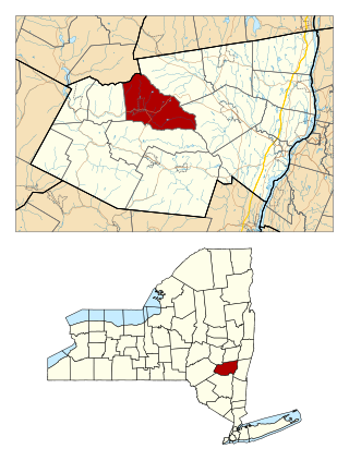
Greene County is a county located in the U.S. state of New York. As of the 2020 census, the population was 47,931. Its county seat is Catskill. The county's name is in honor of the American Revolutionary War general Nathanael Greene. The county is part of the Capital District region of the state.

<span class="mw-page-title-main">Rensselaerville, New York</span> Town in New York, United States

Rensselaerville is a town in Albany County, New York, United States. The population was 1,826 at the 2020 census. The town is named after Stephen Van Rensselaer.

<span class="mw-page-title-main">Greenport, Columbia County, New York</span> Town in New York, United States

Greenport is a town in Columbia County, New York, United States. The population was 4,165 at the 2010 census. The town is on the western border of the county and surrounds the city of Hudson on three sides. US 9 passes through the town.

<span class="mw-page-title-main">Halcott, New York</span> Town in New York, United States

Halcott is a town in Greene County, New York, United States. The population was 249 in 2020, down from 258 at the 2010 census. The town is in the southwestern corner of the county.

<span class="mw-page-title-main">Lexington, New York</span> Town in New York, United States

Lexington is a town in Greene County, New York, United States. The population was 770 at the 2020 census. The town is in the southwestern part of Greene County.

<span class="mw-page-title-main">Mamakating, New York</span> Town in New York, United States

Mamakating is a town in the southeastern section of Sullivan County, New York, United States. The population was 12,655 at the 2020 census.

<span class="mw-page-title-main">Neversink, New York</span> Town in New York, United States

Neversink is a town in Sullivan County, New York, United States. The population was 3,366 at the 2020 census.

<span class="mw-page-title-main">Rockland, New York</span> Town in Sullivan County, New York, US

Rockland is a town in the northern part of Sullivan County, New York, United States. At the 2020 census, the population was 3,290.

<span class="mw-page-title-main">Denning, New York</span> Town in New York, United States

Denning is an isolated town in Ulster County, New York, United States. The population was 493 at the 2020 census. The town is named after an early landowner, William Denning. Denning is located in the western part of the county, deep inside the Catskill Mountains. The location of the town in the Catskill State Park accounts in part for its low population.

<span class="mw-page-title-main">Lloyd, New York</span> Town in New York, United States

Lloyd is a town in Ulster County, New York, United States. The population was 11,133 at the 2020 census. It is part of the New York City combined statistical area.

<span class="mw-page-title-main">Olive, New York</span> Town in New York, United States

Olive is a town in Ulster County, New York, United States. The town is west of Kingston, New York, and is inside the Catskill Park. The population was 4,226 at the 2020 census.

<span class="mw-page-title-main">Phoenicia, New York</span> CDP and hamlet in New York, United States

Phoenicia is a hamlet of Shandaken in Ulster County, New York, United States. The population was 268 at the 2020 census, making it the second highest populated community in the town. The village center is located just off Route 28 at its junction with Route 214 and is nestled at the base of three peaks, Mount Tremper, Romer Mountain, and Sheridan Mountain. The community sits at the confluence of the Esopus Creek and Stony Clove Creek. A popular getaway for New Yorkers, the hamlet has frequented many tourism guides as among the best vacation towns in the greater New York City area.

<span class="mw-page-title-main">Rochester, Ulster County, New York</span> Town in New York, United States

Rochester is a town in Ulster County, New York, United States. The population was 7,272 at the 2020 census. It is an interior town located near the center of Ulster County. The northwestern part of the town is in the Catskill Park.

<span class="mw-page-title-main">Shandaken, New York</span> Town in New York, United States

Shandaken is a town on the northern border of Ulster County, New York, United States, northwest of Kingston, New York. As of the 2020 census, the town had a total population of 2,866. The name is believed to be from an Esopus phrase for "land of rapid waters."

<span class="mw-page-title-main">Wawarsing, New York</span> Town in New York, United States

Wawarsing is a town in Ulster County, New York, United States. The population was 12,771 at the 2020 census. The name Wawarsing was once believed to mean "a place where the streams wind" in the Lenape language, referring to the geography in the hamlet of Wawarsing. Specifically, the joining of the Ver Nooy Kill and the Rondout Creek at Port Ben. The name Wawarsing was used by the Lenape to designate the current hamlet and the fields to the north and south of it for at least six miles in both directions. It is the only Lenape name known to refer to an exact location in Ulster County.

<span class="mw-page-title-main">Stamford (village), New York</span> Village in New York, United States

Stamford is a village in Delaware County, New York, United States. The population was 1,119 at the 2010 census. The village is located partly in the town of Stamford and partly in the town of Harpersfield. The village is on routes 23 and 10. The village has termed itself the "Queen of the Catskills".

<span class="mw-page-title-main">Catskill (town), New York</span> Town in New York, United States

Catskill is a town in the southeastern section of Greene County, New York, United States. The population was 11,298 at the 2020 census, the largest town in the county. The western part of the town is in the Catskill Park. The town contains a village, also called Catskill. The village of Catskill has a well-defined Main Street. There is a public boat launch on the Hudson River called Dutchman's Landing.

<span class="mw-page-title-main">Greenville, Greene County, New York</span> Town in New York, United States

Greenville is a town on the northern border of Greene County, New York, United States. The population was 3,741 at the 2020 census. The town contains a hamlet also named Greenville.

<span class="mw-page-title-main">Hunter, New York</span> Town in New York, United States

Hunter is a town located in Greene County, New York, United States. The population was 3,035 at the time of the 2020 census. The town contains two villages, one named Hunter on the west, and the second called Tannersville, as well as a number of hamlets such as Haines Falls, Platte Clove, Lanesville and Edgewood. Additionally, there are three residential parks location within town limits: Onteora Park, Twilight Park and Elka Park. The town is on the southern border of Greene County and abuts the towns of Woodstock and Saugerties, located in Ulster County.

<span class="mw-page-title-main">Windham (town), New York</span> Town in New York, United States

Windham is a town in Greene County, New York, United States. The population was 1,708 at the 2020 census. The town was probably named for the town or county of Windham, Connecticut, as many of its earliest settlers came from that state as well as other parts of New England. The town has two nicknames: "Land in the Sky" and "Gem of the Catskills".

References

  1. "2016 U.S. Gazetteer Files". United States Census Bureau. Retrieved July 5, 2017.
  2. 1 2 US Census Bureau, 2020 Census Report Hardenburgh, New York https://www.census.gov/search-results.html?searchType=web&cssp=SERP&q=Hardenburgh%20town,%20Ulster%20County,%20New%20York
  3. "Profile for Hardenburgh, New York". ePodunk . Retrieved April 27, 2010.
  4. Gannett, Henry (1905). The Origin of Certain Place Names in the United States. Govt. Print. Off. p.  149.
  5. See, e.g.:
  6. Half of Town's Residents Ordained To Qualify for Tax‐Exempt Status, New York Times (September 19, 1976).
  7. Richard J. Meislin, State Courts Bar Tax Exemptions for 'Mail Clergy'", New York Times (May 1, 1981).
  8. "National Register Information System". National Register of Historic Places . National Park Service. July 9, 2010.
  9. 1 2 3 4 Mary McAleer Vizard, Catskills Towns Waking Up to Zoning, New York Times (September 13, 1992).
  10. 1 2 3 Howard Hendricks, Chapter XIX: Town of Hardenburgh, in The History of Ulster County, New York, Vol. 1 (ed. Alphonso T. Clearwater: W.J. Van Deusen: 1907: reprinted 2007 (Heritage Books), p. 258.
  11. Balsam Lake Mountain Wild Forest, New York State Department of Environmental Conservation.
  12. "Census of Population and Housing". Census.gov. Retrieved June 4, 2015.
  13. "U.S. Census website". United States Census Bureau . Retrieved January 31, 2008.