
Ulster County is a county in the U.S. state of New York. It is situated along the Hudson River. As of the 2020 census, the population was 181,851. The county seat is Kingston. The county is named after the Irish province of Ulster.

Ulster is a town in Ulster County, New York, United States. The population was 12,327 at the 2010 census.

Music from Big Pink is the debut studio album by the Band. Released in 1968, it employs a distinctive blend of country, rock, folk, classical, R&B, blues, and soul. The music was composed partly in "Big Pink", a house shared by bassist/singer Rick Danko, pianist/singer Richard Manuel and organist Garth Hudson in West Saugerties, New York. The album itself was recorded in studios in New York and Los Angeles in 1968, and followed the band's backing of Bob Dylan on his 1966 tour and time spent together in upstate New York recording material that was officially released in 1975 as The Basement Tapes, also with Dylan. The cover artwork is a painting by Dylan.

Newburgh is a town in Orange County, New York, United States. It forms part of the Poughkeepsie—Newburgh—Middletown metropolitan area, which is a part of the New York megacity, and is a suburban satellite of the urbanized city of Newburgh. The city of Newburgh was a part of the town prior to 1865. New York Stewart International Airport is partially located within the township, and much of the land into which it could have been expanded has been turned into Stewart State Forest.

The Catskill Mountains, also known as the Catskills, are a physiographic province of the larger Appalachian Mountains, located in southeastern New York. As a cultural and geographic region, the Catskills are generally defined as those areas close to or within the borders of the Catskill Park, a 700,000-acre (2,800 km2) forest preserve forever protected from many forms of development under New York state law.
New York State Route 32 (NY 32) is a north–south state highway that extends for 176.73 miles (284.42 km) through the Hudson Valley and Capital District regions of the U.S. state of New York. It is a two-lane surface road for nearly its entire length, with few divided and no limited-access sections. From Harriman to Albany, it is closely parallel to Interstate 87 (I-87) and U.S. Route 9W (US 9W), overlapping with the latter in several places.
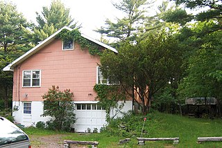
Big Pink is a house in West Saugerties, New York, which was the location where Bob Dylan and The Band recorded The Basement Tapes, and The Band wrote their album Music from Big Pink.

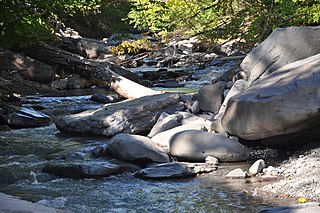
Esopus Creek is a 65.4-mile-long (105.3 km) tributary of the Hudson River that drains the east-central Catskill Mountains in the U.S. state of New York. From its source at Winnisook Lake on the slopes of Slide Mountain, the Catskills' highest peak, it flows across Ulster County to the Hudson at Saugerties. Many tributaries extend its watershed into neighboring Greene County and a small portion of Delaware County. Midway along its length, it is impounded at Olive Bridge to create Ashokan Reservoir, the first of several built in the Catskills as part of New York City's water supply system. Its own flow is supplemented 13 miles (21 km) above the reservoir by the Shandaken Tunnel, which carries water from the city's Schoharie Reservoir into the creek.
New York State Route 212 (NY 212) is an east–west state highway located entirely within Ulster County, New York, in the United States. It runs for 21.92 miles (35.28 km) from an intersection with NY 28 in the interior of the Catskill Park to a junction with U.S. Route 9W (US 9W) and NY 32 on the west bank of the Hudson River, providing a key interchange with the New York State Thruway along the way. The mostly rural two-lane route serves the communities of Woodstock and Saugerties while passing Cooper Lake, Kingston's reservoir. NY 212 was assigned as part of the 1930 renumbering of state highways in New York.
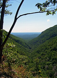
Platte Clove, sometimes Plattekill Clove, is a narrow and steep valley in the Catskill Mountains of New York.

Locust Lawn is a surviving 19th-century farm complex situated on the bank of the Plattekill Creek on New York State Route 32, outside of New Paltz, Ulster County, New York.

Quassaick Creek is an 18.4-mile-long (29.6 km) tributary of the Hudson River in Orange and Ulster counties in the U.S. state of New York. It rises in the glacial ridges west of the river, near the boundary between the towns of Plattekill and Marlborough. From there it flows south into the town of Newburgh and then the city, where it eventually forms part of the border between it and neighboring New Windsor before emptying into the Hudson.

The Wynkoop House is located on New York Route 32 just north of an offramp from the New York State Thruway and its junction with NY 212 in the town of Saugerties, New York, United States. It is a linear stone house built in two sections by the descendants of Dutch settlers around 1740, and renovated in later years.

Kingston is a city in and the county seat of Ulster County, New York, United States. It is 91 miles (146 km) north of New York City and 59 miles (95 km) south of Albany. The city's metropolitan area is grouped with the New York metropolitan area around Manhattan by the United States Census Bureau. The population was 24,069 at the 2020 United States Census.

Plattekill is a hamlet in Ulster County, New York, United States. The population was 1,260 at the 2010 census. The community, as is the town, is named after a local stream, the Platte Kill.

Plattekill is a town in Ulster County, New York, United States. The population was 10,499 at the 2010 census. The name is derived from a stream, the Platte Kill.

Saugerties is a village in Ulster County, New York, United States.

Saugerties is a town in Ulster County, New York, United States. The population was 19,482 at the 2010 census. The Town of Saugerties contains the Village of Saugerties in the northeastern corner of Ulster County. Part of the town is inside Catskill Park.
"Santa-Fe" is a song that was recorded by Bob Dylan and the Band in the summer or fall of 1967 in West Saugerties, New York. It was recorded during the sessions that would in 1975 be released on The Basement Tapes but was not included on that album. These sessions took place in three phases throughout the year, at a trio of houses, and "Santa-Fe" was likely put on tape in the second of these, at a home of some of the Band members, known as Big Pink. The composition, which has been characterized as a "nonsense" song, was copyrighted in 1973 with lyrics that differ noticeably from those on the recording itself.
Saw Kill is a 19.7-mile-long (31.7 km) main tributary that drains into Esopus Creek on the Hudson’s west bank.

