Catskill Mountains

Last updated

Catskill Mountains
Central Catskills from Twin south summit.jpg
Slide Mountain and nearby peaks as seen from Twin Mountain in the northern Catskills
Highest point
Peak Slide Mountain
Elevation 4,180 ft (1,270 m)
Coordinates 41°59′55″N74°23′11″W / 41.99861°N 74.38639°W / 41.99861; -74.38639
Dimensions
Length111 mi (179 km)N/S
Width102 mi (164 km)E/W
Area15,259 km2 (5,892 sq mi)
Geography
NortheastAppalachiansMap.gif
Main regions of the northeast Appalachians, with the Catskills as "C"
CountryUnited States
State New York
Region Hudson Valley, Southern Tier, Mohawk Valley
Counties Delaware, Greene, Schoharie, Sullivan and Ulster
Rivers Esopus Creek, Neversink River, Rondout Creek and Schoharie Creek
Communities Ellenville, Fleischmanns, Hunter, Liberty, Margaretville, Hancock, New York, Palenville, Phoenicia, Shandaken, Shokan, Tannersville, Wawarsing, Windham and Woodstock
Parent range Appalachian (Allegheny Plateau)
Borders on Poconos, Shawangunk Ridge, Hudson Valley, Great Appalachian Valley and Mohawk Valley
Geology
Age of rock Devonian and Mississippian
Type of rock Sedimentary

The Catskill Mountains, also known as the Catskills, are a physiographic province and subrange of the larger Appalachian Mountains, located in southeastern New York. As a cultural and geographic region, the Catskills are generally defined as those areas close to or within the borders of the Catskill Park, a 700,000-acre (2,800 km2) forest preserve protected from many forms of development under New York state law.

Contents

Geologically, the Catskills are a mature dissected plateau, a flat region subsequently uplifted and eroded into sharp relief by watercourses. The Catskills form the northeastern end of the Allegheny Plateau (also known as the Appalachian Plateau). [1] [2]

The Catskills were named by early Dutch settlers. They are well known in American society as the setting for films and works of art, including many 19th-century Hudson River School paintings, as well as for being a favored destination for vacationers from New York City in the mid-20th century. The region's many large resorts gave many young stand-up comedians an opportunity to hone their craft. Since the late 19th century, the Catskills have been a haven for artists, musicians and writers, especially in and around the towns of Woodstock and Phoenicia.

History

Etymology

Views of the Catskills from the Hudson like this led to the name "Blue Mountains" for a time. Catskills beyond Hudson.jpg
Views of the Catskills from the Hudson like this led to the name "Blue Mountains" for a time.
A 1685 revision of a 1656 map of New Netherland showing the locations of the "Lands of the Kats Kills" and the "High Lands of the Esopus" Map-Novi Belgii Novaeque Angliae (Amsterdam, 1685).jpg
A 1685 revision of a 1656 map of New Netherland showing the locations of the "Lands of the Kats Kills" and the "High Lands of the Esopus"

Nicolaes Visscher I's 1656 map of New Netherland located the Landt van Kats Kill at the mouth of Catskill Creek. The region to the south is identified as Hooge Landt van Esopus (High Lands of the Esopus), a reference to a local band of northern Lenape Native Americans who inhabited the banks of the Hudson and hunted in the highlands along the Esopus Creek. [3]

While the meaning of the name ("cat creek [ kill ]" in Dutch) and the namer (early Dutch explorers) are settled matters, how and why the area is named "Catskills" is a mystery. Mountain lions (catamounts) were known to have been in the area when the Dutch arrived in the 17th century and may have been a reason for the name. [4]

The confusion over the origins of the name led over the years to variant spellings such as Kaatskill and Kaaterskill, both of which are also still used: the former in the regional magazine Kaatskill Life , the latter as the name of a mountain peak and a waterfall. The supposed Native American name for the range, Onteora ("land in the sky"), was purportedly created in the mid-19th century to drum up business for a resort.[ citation needed ] It is still the name of a school district and as the name of a Boy Scout summer camp (Onteora Scout Reservation).

Geography

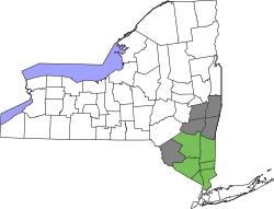
The Catskill Mountains are approximately 100 miles (160 km) north-northwest of New York City and 40 miles (64 km) southwest of Albany, starting west of the Hudson River. The Catskills occupy much of two counties (Greene and Ulster), and extend slightly into Delaware, Sullivan, and southwestern Schoharie counties.

At the range's eastern end, the mountains begin dramatically with the Catskill Escarpment rising up suddenly from the Hudson Valley. The western boundary is far less certain, as the mountains gradually decline in height and grade into the rest of the Allegheny Plateau, but maps from the 18th and 19th centuries consistently mark the border of the Catskill Mountains as the East Branch of the Delaware River, which is consistent with the actual topographic relief. [5] The Pocono Mountains, to the immediate southwest in Pennsylvania, are also a part of the Allegheny Plateau.

The Catskills contain more than 30 peaks above 3,500 feet (1,100 m) and parts of six important rivers. The Catskill Mountain 3500 Club is an organization whose members have climbed all the peaks in the Catskills over 3,500 feet (1,100 m). The highest mountain, Slide Mountain in Ulster County, has an elevation of 4,180 feet (1,270 m).

Free-floating tubers on Esopus Creek Tubers on Esopus Creek 2011.jpg
Free-floating tubers on Esopus Creek

Climatically, the Catskills lie within the Allegheny Highlands forests ecoregion.

Climate

According to the Köppen climate classification system, the Catskill Mountains have two climate zones. The vast majority of the Catskills have a warm summer humid continental climate (Dfb) with some isolated locations in valleys with hot summer humid continental climate (Dfa). The plant hardiness zone on Slide Mountain at 4,180 feet (1,270 m) is 5a with an average annual extreme minimum temperature of −16.6 °F (−27.0 °C). The plant hardiness zone in Margaretville at 1,000 feet (300 m) is 5b with an average annual extreme minimum temperature of −10.6 °F (−23.7 °C). [6]

Climate data for Phoenicia, Ulster County NY. Elevation: 900 ft (274 m)
MonthJanFebMarAprMayJunJulAugSepOctNovDecYear
Mean daily maximum °F (°C)34.4
(1.3)
37.9
(3.3)
47.4
(8.6)
60.8
(16.0)
71.0
(21.7)
79.9
(26.6)
83.4
(28.6)
82.3
(27.9)
75.1
(23.9)
62.8
(17.1)
51.0
(10.6)
39.4
(4.1)
60.4
(15.8)
Daily mean °F (°C)26.9
(−2.8)
29.1
(−1.6)
36.5
(2.5)
50.5
(10.3)
60.1
(15.6)
68.9
(20.5)
74.3
(23.5)
71.8
(22.1)
66.4
(19.1)
51.0
(10.6)
41.3
(5.2)
30.5
(−0.8)
49.4
(9.7)
Mean daily minimum °F (°C)18.1
(−7.7)
20.0
(−6.7)
27.8
(−2.3)
40.5
(4.7)
51.4
(10.8)
57.9
(14.4)
62.9
(17.2)
61.0
(16.1)
56.3
(13.5)
42.6
(5.9)
32.9
(0.5)
22.9
(−5.1)
38.4
(3.6)
Average precipitation inches (mm)3.6
(91)
3.98
(101)
3.82
(97)
4.0
(100)
3.9
(99)
3.2
(81)
2.6
(66)
2.9
(74)
3.02
(77)
3.6
(91)
3.7
(94)
3.5
(89)
46.33
(1,177)
Average relative humidity (%)69.166.259.255.860.867.470.870.071.069.769.969.366.0
Source: PRISM Climate Group [7]
Climate data for Margaretville, Delaware County, NY. Elevation: 1,000 ft (300 m)
MonthJanFebMarAprMayJunJulAugSepOctNovDecYear
Mean daily maximum °F (°C)34.8
(1.6)
38.3
(3.5)
47.7
(8.7)
61.0
(16.1)
71.4
(21.9)
80.1
(26.7)
83.8
(28.8)
82.4
(28.0)
75.4
(24.1)
63.0
(17.2)
51.5
(10.8)
39.8
(4.3)
60.8
(16.0)
Daily mean °F (°C)27.1
(−2.7)
29.2
(−1.6)
36.9
(2.7)
50.0
(10.0)
60.2
(15.7)
69.0
(20.6)
74.4
(23.6)
71.9
(22.2)
66.6
(19.2)
51.4
(10.8)
41.8
(5.4)
30.8
(−0.7)
49.8
(9.9)
Mean daily minimum °F (°C)18.4
(−7.6)
20.1
(−6.6)
28.0
(−2.2)
40.1
(4.5)
51.9
(11.1)
58.0
(14.4)
63.5
(17.5)
61.4
(16.3)
56.4
(13.6)
42.9
(6.1)
33.1
(0.6)
23.2
(−4.9)
38.8
(3.8)
Average precipitation inches (mm)3.6
(91)
3.63
(92)
3.8
(97)
4.0
(100)
3.9
(99)
3.2
(81)
2.5
(64)
2.9
(74)
3.0
(76)
3.6
(91)
3.63
(92)
3.5
(89)
46.32
(1,177)
Average relative humidity (%)68.564.358.555.861.667.470.970.271.769.968.569.866.0
Source: PRISM Climate Group [7]
MonthJanFebMarAprMayJunJulAugSepOctNovDecYear
Average Dew Point  °F16.217.724.334.348.657.863.261.755.841.932.222.138.9
Average Dew Point  °C-8.8-7.9-4.61.17.613.616.215.912.15.50.1-5.53.8
Source: PRISM Climate Group [7]

Geology

Kaaterskill Falls on Spruce Creek near Palenville, New York. One of the higher falls in New York. Two separate falls total 260 ft (79 m). Kaaterskill Falls.jpg
Kaaterskill Falls on Spruce Creek near Palenville, New York. One of the higher falls in New York. Two separate falls total 260 ft (79 m).

Although the Catskills are sometimes compared with the Adirondack Mountains farther north, the two mountain ranges are not geologically related, as the Adirondacks are a continuation of the Canadian Shield. Similarly, the Shawangunk Ridge, which forms the southeastern edge of the Catskills, is part of the geologically distinct Ridge-and-Valley province and is a continuation of the same ridge known as Kittatinny Mountain in New Jersey and Blue Mountain in Pennsylvania.

The Catskill Mountains are more of a dissected plateau [8] than a series of mountain ranges. The sediments that make up the rocks in the Catskills were deposited when the ancient Acadian Mountains in the east were rising and subsequently eroding. The sediments traveled westward and formed a great delta into the sea that was in the area at that time. The escarpment of the Catskill Mountains is near the former (landward) edge of this delta, as the sediments deposited in the northeastern areas along the escarpment were deposited above sea level by moving rivers, and the Acadian Mountains were located roughly where the Taconic Mountains are located today (though significantly larger). Finer sediment was deposited further westward, and thus the rocks change from gravel conglomerates to sandstone and shale. Further west, these fresh water deposits intermingle with shallow marine sandstone and shale until the end, in deeper water limestone.

The uplift and erosion of the Acadian Mountains was occurring during the Devonian [9] and early Mississippian period (395 to 325 million years ago). Over that time, thousands of feet of these sediments built up, slowly moving the Devonian seashore further west. A meteor impact occurred in the shallow sea approximately 375 mya, creating a 10 km (6 mi) diameter crater. This crater eventually filled with sediments and became Panther Mountain through the process of uplift and erosion. By the middle of the Mississippian period, the uplift stopped, and the Acadian Mountains had been eroded so much that sediments no longer flowed across the Catskill Delta.

Platte Clove, a break in the Catskill Escarpment created by glacial action Platte Clove.jpg
Platte Clove, a break in the Catskill Escarpment created by glacial action

Over time, the sediments were buried by more sediments from other areas, until the original Devonian and Mississippian sediments were deeply buried and slowly became solid rock. Then the entire area experienced uplift, which caused the sedimentary rocks to begin to erode. Today, those upper sedimentary rocks have been completely removed, exposing the Devonian and Mississippian rocks. Today's Catskills are a result of the continued erosion of these rocks, both by streams and, in the recent past, by glaciers.

In successive ice ages, both valley and continental glaciers have widened the valleys and the notches of the Catskills and rounded the mountains. Grooves and scratches in exposed bedrock provide evidence of the great sheets of ice that once traversed the region. Even today the erosion of the mountains continues, with the region's rivers and streams deepening and widening the mountains' valleys and cloves.

Recreation

The Borscht Belt

In the mid–20th century, summer resorts in the Catskills, nicknamed the Borscht Belt, were a major vacation destination for Jewish New Yorkers. At its peak of popularity, about 500 resorts operated in the region. [10] Later changes in vacationing patterns have led most of those travelers elsewhere, although there are still some bungalow communities and summer camps in the region catering to Orthodox populations.

Aquatic sports and recreation

The Ashokan Reservoir as seen from Wittenberg Mountain Ashokan Reservoir from Wittenberg.jpg
The Ashokan Reservoir as seen from Wittenberg Mountain

Esopus Creek is a 65.4-mile (105.3 km) tributary of the Hudson River, starting at Winnisook Lake on Slide Mountain. It flows across Ulster County to the Hudson River at Saugerties. The Esopus is noted for making an almost 270-degree turn around Panther Mountain, following a buried 6-mile (10 km) impact crater rim. It is famous for tubing, a sport of rafting down a river in an inner tube. Many tubers begin their trip at Phoenicia, New York, and head down the creek towards the Ashokan Reservoir at Olive, New York.

The Ashokan Reservoir is part of the New York City water supply system, with fishing allowed under permit, but swimming and most other recreational uses are forbidden.

River canoeing and kayaking are popular. There are 42 rapids ranging from class I to V+. [11]

The Esopus Creek is famous for its fly fishing, although in recent years[ when? ] it has been plagued by invasive plants. [12]

Cycling

Road and mountain biking are fairly popular in the range. Bicycle racing includes the Tour of the Catskills, a three-day road stage race held in Green and Ulster counties each summer, [13] and the UCI Mountain Bike World Cup in Windham. [14] Other cycling resources include the Catskill Scenic Trail, the Headwaters Trails in Stamford and the Roundtopia trail network (mapped by the Round Top Mountain Bike Association). [15] Several ski centers provide downhill mountain bicycling in the warmer months.

Hiking and camping

Within the range is the Catskill Park, comprising over 700,000 acres (280,000 ha). Catskill Park is part of New York's Forest Preserve. Not all the land is publicly owned; about 60% remains in private hands, but new sections are added frequently. Most of the park and the preserve are within Ulster County, with a significant portion in Greene County, and parts in Sullivan and Delaware counties as well. Many of the trails in public areas are maintained and updated by the New York–New Jersey Trail Conference and the Catskill Mountain 3500 Club.

Hunter Mountain Hunter Mountain ski area.jpg
Hunter Mountain

Devil's Path is one of the many trails open for hikers. Spots to camp in the Catskills include Bear Spring Mountain, Little Pond, Mongaup Pond, and North-South Lake. [16]

Skiing

There are five main downhill ski and snowboard areas in the Catskills: Belleayre Mountain (run by the Olympic Regional Development Authority); Hunter Mountain (the first ski area to install snowmaking machines in New York); Windham Mountain; Holiday Mountain Ski and Fun in Monticello; and Plattekill Mountain in Roxbury.

Joppenbergh Mountain, in Rosendale Village hosted its first ski jumping competition in 1937. Ski jumping was continued on the mountain until February 7, 1971, when the last competition was held.

The Mountain Trails Cross Country Ski Center in Tannersville has 22 miles (35 km) of trails.

Structures

Fire towers

Balsam Lake Mountain fire tower in 2008 Balsam Lake Mountain fire tower.jpg
Balsam Lake Mountain fire tower in 2008

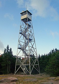
The Catskill Mountains fire towers were constructed to facilitate forest fire prevention and control. Twenty-three fire towers were built in the Catskill Mountains between 1908 and 1950. The fire towers fell out of use by the 1970s as fire spotting from airplanes had become more effective and efficient, so the fire towers were decommissioned; the Hunter Mountain Fire Tower was the last to be taken out of service in 1990. All but six of the towers were dismantled. The five remaining towers have been renovated and opened to the public as observation posts with panoramic views and a sixth tower was opened at the Catskill Visitor Center in 2022. The current towers are:

Notable landmarks

The Catskill Mountain House, built in 1824, was a hotel near Palenville, New York, in the Catskill Mountains overlooking the Hudson River Valley. In its prime at the turn of the century, visitors included United States Presidents Ulysses S. Grant, Chester A. Arthur and Theodore Roosevelt.

Transportation

From 1872, the northern part of the Catskills were served by the Catskill Mountain Branch of the Ulster and Delaware Railroad which was absorbed into the New York Central railroad in 1932. Oneonta to Kingston passenger rail service continued until 1954. Part of the line still exists but now serves only freight.

The southern part of the Catskills was served by the New York, Ontario and Western Railway. Over the course of 1950, service on the NYO&W downscaled to summer only. In its last years it ran trains from Roscoe to Weehawken, New Jersey, via Liberty. It connected with the New York Central's West Shore Railroad at Cornwall. [17] [18] This service lasted until September 10, 1953. [19]

The Delaware and Ulster Railroad is a heritage railroad, based in Arkville, New York, that still runs a scenic part of the track from Highmount to Hubbell Corners, New York, for tourist use. The Catskill Mountain Railroad is also a heritage railroad in the Catskills, operating from Kingston up to Highmount.

A map of the railroads in the Catskills. Despite what the map says, nearly the entirety of this map is of the Catskills. East of the Hudson River are The Berkshires and the Taconic Mountains, and to the far north (central and northern Albany County, and far-northern Schoharie County) are the Appalachians. Udmap.jpg
A map of the railroads in the Catskills. Despite what the map says, nearly the entirety of this map is of the Catskills. East of the Hudson River are The Berkshires and the Taconic Mountains, and to the far north (central and northern Albany County, and far-northern Schoharie County) are the Appalachians.

The Catskills are accessible by automobile from the east along Interstate 87/New York State Thruway, which runs north–south through the Hudson Valley. To the south and southwest, the Catskills are accessible by a variety of highways, including New York State Route 55, U.S. Route 44, U.S. Route 209, and New York State Route 17. Access to the western Catskills is provided by New York State Route 30; and the vaguely defined far-western edge of the region is variously considered to be New York State Route 10 or Interstate 88, though this boundary remains a matter of local preference. New York State Routes 28 and 23A cut east–west through the heart of the Catskills, serving many of the most popular outdoor tourist destinations. New York State Route 23 runs east–west across the Catskills' northern section.

The closest major airports to the Catskill region are Albany International Airport to the north and Stewart International Airport in Newburgh to the south. Smaller airports in the region include:

The Catskills serve as the setting for many works of fiction, such as the short story Rip Van Winkle, and the children's book My Side of the Mountain . The Hudson Valley Film Commission maintains a list of films set in the Hudson Valley/Catskills Region. [20] Of them, more than three dozen films are set in the Catskills.

The town of Bethel, New York, located in the Catskills, was home to the famous Woodstock music festival that took place August 15–18, 1969. The event, wherein 32 music acts performed in front of over 500,000 concert-goers, was captured in the documentary movie Woodstock (1970). The site is now home to the world-renowned Bethel Woods Center for the Arts.

The many hotels and vacation resorts located in the Catskills are notable in American cultural history for their role in the development of modern stand-up comedy. Comedians such as Rodney Dangerfield, Jackie Mason, Alan King, and Don Rickles all got their start performing in Catskill hotel venues colloquially referred to as the Borscht Belt. [21]

See also

Related Research Articles

<span class="mw-page-title-main">Ulster County, New York</span> County in New York, United States

Ulster County is a county in the U.S. state of New York. It is situated along the Hudson River. As of the 2020 census, the population was 181,851. The county seat is Kingston. The county is named after the Irish province of Ulster. The county is part of the Hudson Valley region of the state.

<span class="mw-page-title-main">Catskill Park</span> Nature preserve in southeastern New York, U.S.

The Catskill Park is in the Catskill Mountains in the U.S. state of New York. It consists of 700,000 acres of land inside a Blue Line in four counties: Delaware, Greene, Sullivan, and Ulster. As of 2005, 287,500 acres (116,300 ha) or 41 percent of the land within, is owned by the state as part of the Forest Preserve; it is managed by the Department of Environmental Conservation (DEC). Another 5% is owned by New York City to protect four of the city's reservoirs in the region that lie partially within the park and their respective watersheds.

<span class="mw-page-title-main">Endless Mountains</span> Mountainous region in northeast Pennsylvania

The Endless Mountains are a geographical, geological, and cultural region in Northeastern Pennsylvania. The Endless Mountains region includes Bradford, Sullivan, Susquehanna,and Wyoming counties. The highest peak in the region is the North Knob of Elk Mountain at 2,693 feet. The dissected plateau is a subrange of the Appalachian Mountains.

<span class="mw-page-title-main">Hunter Mountain (New York)</span> Highest mountain in Greene County, New York, and second highest in the Catskills

Hunter Mountain is in the towns of Hunter and Lexington, just south of the village of Hunter, in Greene County, New York, United States. At approximately 4,040 feet (1,231 m) in elevation, it is the highest peak in the county and the second-highest peak in the Catskill Mountains.

<span class="mw-page-title-main">Stony Clove Notch</span> Mountain pass in Greene County, New York

Stony Clove Notch is a narrow pass, roughly 2,220 feet in elevation located in the Town of Hunter in Greene County, New York, deep in the Catskill Mountains. It is traversed by New York State Route 214, although in the past the Ulster and Delaware Railroad went through it as well.

<span class="mw-page-title-main">Esopus Creek</span> Tributary of the Hudson River in the Catskill region of New York state

Esopus Creek is a 65.4-mile-long (105.3 km) tributary of the Hudson River that drains the east-central Catskill Mountains in the U.S. state of New York. From its source at Winnisook Lake on the slopes of Slide Mountain, the Catskills' highest peak, it flows across Ulster County to the Hudson at Saugerties. Many tributaries extend its watershed into neighboring Greene County and a small portion of Delaware County. Midway along its length, it is impounded at Olive Bridge to create Ashokan Reservoir, the first of several built in the Catskills as part of New York City's water supply system. Its own flow is supplemented 13 miles (21 km) above the reservoir by the Shandaken Tunnel, which carries water from the city's Schoharie Reservoir into the creek.

<span class="mw-page-title-main">Hunter Mountain Fire Tower</span> Historic fire lookout tower in New York, United States

The Hunter Mountain Fire Tower is located on the summit of the eponymous mountain, second highest of the Catskill Mountains in the U.S. state of New York. It was the first of 23 fire lookout towers built by the state in the region, and the next-to-last of the five still standing to be abandoned.

<span class="mw-page-title-main">Halcott Mountain</span> Mountain in the Catskill range in U.S. state of New York

Halcott Mountain is one of the Catskill Mountains of the U.S. state of New York. It is mostly located in Greene County, with some of its lower slopes in Delaware and Ulster counties. Its exact summit elevation has not been officially determined, but the highest contour line on the mountain is 3,520 feet (1,070 m). It is one of the peaks on the divide between the Delaware and Hudson watersheds.

<span class="mw-page-title-main">Sugarloaf Mountain (Greene County, New York)</span> Mountain located in Greene County, New York

Sugarloaf Mountain is a mountain located in Greene County, New York. The mountain is part of the Devil's Path range of the Catskill Mountains. To the northwest, Sugarloaf is separated from Plateau Mountain by Mink Hollow Notch; to the southeast, Sugarloaf is separated from Twin Mountain by Pecoy Notch.

<span class="mw-page-title-main">Balsam Mountain (Ulster County, New York)</span> 28th highest peak of Catskill Mountains

Balsam Mountain is one of the High Peaks of the Catskill Mountains in the U.S. state of New York. Its exact height has not been determined, so the highest contour line, 3,600 feet (1,100 m), is usually given as its elevation. It is located in western Ulster County, on the divide between the Hudson and Delaware watersheds. The summit and western slopes of the peak are within the Town of Hardenburgh and its eastern slopes are in Shandaken. The small community of Oliverea is near its base on that side. Most of the mountain is publicly owned, managed by the New York State Department of Environmental Conservation as part of the state Forest Preserve, part of the Big Indian-Beaverkill Range Wilderness Area in the Catskill Park. The summit is on a small corner of private land.

<span class="mw-page-title-main">Balsam Lake Mountain</span> Westernmost of the Catskill High Peaks in U.S. state of New York

Balsam Lake Mountain is one of the Catskill Mountains, located in the Town of Hardenburgh, New York, United States. It is the westernmost of the range's 35 High Peaks. Its exact height has not been determined, but the highest contour line on topographic maps, 3,720 feet (1,130 m), is usually given as its elevation.

<span class="mw-page-title-main">Graham Mountain (New York)</span> Highest privately owned summit in New Yorks Catskill Mountains

Graham Mountain is the seventh highest of the Catskill High Peaks and the highest privately owned mountain in the range. It is located in the town of Hardenburgh, New York, United States.

<span class="mw-page-title-main">Cornell Mountain</span> Mountain located in Ulster County, New York

Cornell Mountain is a mountain located in Ulster County, New York. The mountain is part of the Burroughs Range of the Catskill Mountains. Cornell Mountain is flanked to the northeast by Wittenberg Mountain, to the southwest by Friday Mountain, and to the west by 4,180-foot (1,270 m) Slide Mountain — the highest peak in the Catskills.

<span class="mw-page-title-main">Wittenberg Mountain</span> Mountain in the United States

Wittenberg Mountain, locally "the Wittenberg'', is a mountain in Ulster County, New York. It is part of the Burroughs Range of the Catskill Mountains. Wittenberg is flanked to the southwest by Cornell Mountain and to the northeast by Terrace Mountain.

<span class="mw-page-title-main">Brace Mountain</span> Mountain in New York, United States

Brace Mountain is the peak of a ridge in the southern Taconic Mountains, near the tripoint of the U.S. states of New York, Connecticut and Massachusetts. Its 2,311-foot (704 m) main summit is located in New York; it is the highest point in that state's Dutchess County.

<span class="mw-page-title-main">Red Hill Fire Observation Station</span> United States historic place

The Red Hill Fire Observation Station consists of a fire lookout tower, cabin and pit privy located on the summit of Red Hill, a 2,990-foot (910 m) Catskill Mountain peak in Denning, New York, United States. It is the southernmost fire tower in the Catskill Park.

<span class="mw-page-title-main">Catskill Escarpment</span> Mountain range in New York, U.S.

The Catskill Escarpment, often referred to locally as just the Escarpment or the Great Wall of Manitou, and known as the Catskill Front to geologists, is the range forming the northeastern corner of the Catskill Mountains in Greene and Ulster counties in the U.S. state of New York. It rises very abruptly from the Hudson Valley to summits above 3,000 feet (910 m) in elevation, including three of the Catskill High Peaks, with almost no foothills. The plateau to the south and west averages 2,000 feet (610 m) above sea level.

<span class="mw-page-title-main">Mount Tremper</span> Mountain in U.S. state of New York

Mount Tremper, officially known as Tremper Mountain and originally called Timothyberg, is one of the Catskill Mountains in the U.S. state of New York. It is located near the hamlet of Phoenicia, in the valley of Esopus Creek.

<span class="mw-page-title-main">Balsam Lake Mountain Fire Observation Station</span> Former fire lookout tower in the Catskill Mountains of New York, USA

The Balsam Lake Mountain Fire Observation Station is located at the summit of the mountain of that name in the Town of Hardenburgh, New York, United States. It comprises a steel frame fire lookout tower, the observer's cabin and privy and the jeep road to the complex.

<span class="mw-page-title-main">Marlboro Mountains</span> Mountain in the United States

The Marlboro Mountains, sometimes Marlborough Mountains, are a group of hogbacked mountains arranged in a 25-mile-long (40 km) ridge extending from Newburgh, New York, to just south of Kingston, New York. Considered to be part of the Ridge and Valley Appalachians, the mountains, which reach elevations over 1,100 feet, form an imposing geologic barrier just west of the Hudson River. They subdivide the relatively flat Hudson River Valley to create the Wallkill Valley further west. Rising abruptly on their eastern flanks, the Marlboro Mountains are known for their sweeping views of the region.

References

  1. "REGIONAL TOPOGRAPHY". Catskills GIS Atlas. Catskill Center. Archived from the original on October 29, 2009. Retrieved October 12, 2009.
  2. "Physiographic divisions of the conterminous U. S". U.S. Geological Survey. Retrieved December 6, 2007.
  3. Kudish, Michael (2000). The Catskill Forest: A History. Fleischmanns, NY: Purple Mountain Press. p. 47. ISBN   978-1-930098-02-2.
  4. "The Elusive Mountain Lion – E-Files – Our History". Sierra Club. Archived from the original on August 7, 2007. Retrieved September 17, 2007.
  5. "Search results - NYPL Digital Collections".
  6. "USDA Interactive Plant Hardiness Map". United States Department of Agriculture . Retrieved July 9, 2019.
  7. 1 2 3 "PRISM Climate Group, Oregon State University". www.prism.oregonstate.edu. Retrieved July 9, 2019.
  8. "Geology of National Parks, 3D and Photographic Tours". USGS. USGS. Retrieved August 6, 2018.
  9. Ver Straeten, C. A (2013). "Beneath it all: bedrock geology of the Catskill Mountains and implications of its weathering". Annals of the New York Academy of Sciences. 1298: 1–29. doi:10.1111/nyas.12221. PMID   23895551. S2CID   19940868.
  10. Stanley Turkel (August 1, 2019). "Hotel History: Catskill Mountain Resort Hotels". Hospitality Net.
  11. "Whitewater Rivers in and near the Catskill Mountains, New York" . Retrieved May 10, 2013.
  12. DePalma, Anthony (June 15, 2009). "An Unsightly Algae Extends Its Grip to a Crucial New York Stream". The New York Times. Retrieved May 28, 2019.
  13. "Tour of the Catskills". Anthem Sports. Retrieved December 18, 2013.
  14. "Windham Mountain Bike World Cup Festival". Archived from the original on March 26, 2016. Retrieved December 18, 2013.
  15. "The trail system". Round Top Mountain Bike Association. October 20, 2019. The Round Top trail system evolved from the local riding scene of the 90s.
  16. "Catskill Interpretive Center" . Retrieved October 18, 2017.
  17. 'Official Guide of the Railways,' January 1950, New York, Ontario and Western section
  18. Official Guide of the Railways, December 1950, New York, Ontario and Western section, page reproduced at http://www.thejoekorner.com/brochures/nyow-og-timetable/index.html
  19. American Rails, 'New York, Ontario and Western Railway' https://www.american-rails.com/nyow.html
  20. "Woodstock Film Commission". Hudsonvalleyfilmcommission.org. Archived from the original on September 22, 2013. Retrieved March 26, 2014.
  21. "Comedians who became stars learned their craft in Catskill Mountain hotels". tribunedigital-sunsentinel. Archived from the original on December 29, 2015. Retrieved January 14, 2016.
  22. "The Catskills". The Walters Art Museum.

Further reading