Catskill Mountain 3500 Club

Last updated
Catskill Mountain 3500 Club
Formation1962;62 years ago (1962)
Type Nonprofit
52-1935612
Headquarters West Hurley, New York
Membership
~3,300
Official language
English
Website catskill-3500-club.org

The Catskill Mountain 3500 Club, incorporated as the Catskill 3500 Club and often just referred to as the 3500 Club, is a peakbagging organization for hikers in the Catskill Mountains of New York. Those wishing to become members must climb all 35 Catskill High Peaks and, in a departure from the requirements of most other such clubs, climb Slide, Blackhead, Balsam and Panther mountains again in winter, which is defined by the Club's by-laws as the period from December 21 to March 21 regardless of the actual occurrences of the winter solstice and vernal equinox in particular years. The Club also awards a separate patch for those who go on to climb all 35 peaks during winter.

Contents

Membership

3500 Club summit canister, shown prior to change in color and removal of exterior text requested by NYSDEC. 3500 Club Summit canister.jpg
3500 Club summit canister, shown prior to change in color and removal of exterior text requested by NYSDEC.

Members record their climbs on a tally sheet and then submit them to the Club's membership chair when they have completed their last required peak. This is mostly done on the honor system; however sometimes the tally sheets are cross-checked against the logs kept in the canisters the club maintains at the summits of the 13 peaks that lack a trail to the summit.

As of May 2020 there are 3,323 regular members and 1,335 winter members. [1] Those who have not yet finished the prescribed 39 climbs (35 regular, 4 winter) are referred to as aspirants. Members and aspirants alike may subscribe to the quarterly newsletter of the organization, The Catskill Canister, for $10 per annum. In the case of members, this payment additionally represents an annual dues payment; those who are paid up are considered active members. The organization offers lifetime memberships.

History

The Club traces its origins to the early 1950s, when Dan Smiley, a descendant of the founders of Mohonk Mountain House and his fellow birders were trying to track down the elusive Bicknell's thrush, then considered an unimportant subspecies of the gray-cheeked thrush. Since it prefers to mate and spend its summers in cool, shady places like the boreal forests found on the summits of higher mountains in the Northeast, Smiley and his fellow birders drew up a list of the peaks in the Catskills over 3,500 feet and thus likely to have such forestation.

Their goal was not to bag peaks but simply to find the thrush. Nonetheless, they published their list of (at that time) 33 peaks in a nature journal. Area hikers who saw it began organizing trips to the peaks with an eye toward completing the list, and in 1962 informally organized the club as a Catskill counterpart to the well-established Adirondack Forty-Sixers. Later that year William and Elinore Leavitt of Hudson became the first two members of the club, after newly issued maps resulted in the addition of Friday and Mount Sherrill to the list at the expense of Dry Brook Ridge.

In 1966 the Club was formally incorporated, and has counted that year as its founding date ever since. The Leavitts and 23 others who had climbed all the peaks in the meantime were accepted as charter members. Three of the five people who had played important roles in founding the club were, for various reasons, never able to become members; and Dan Smiley himself died with only one climb left for membership.

The peak list would remain in this form until 1991, when Southwest Hunter Mountain, a trailless peak lacking an official name, was added after a contentious membership vote. It had originally been left off the list due to uncertainty over whether it was really a separate peak or not and the difficulty of establishing where its summit was.

In 2021 the Gould family, which owns the summits of Graham and Doubletop, closed off access to those two peaks due to the impact of greatly increased hiking on the area, particularly after the COVID-19 pandemic had led to an increase in outdoor recreation the year before. The club has advised aspiring members to climb to Doubletop's slightly lower southern summit, on state land, and Mill Brook Ridge in the meantime, and removed the canister from Doubletop.

Activities

The Club sponsors hikes on almost every weekend of the year to the various peaks, and sometimes to other mountains of interest in the Catskills. It is also responsible for maintaining the trail over Peekamoose and Table mountains, and does litter cleanup on the section of Route 214 south of Stony Clove Notch (Both routes are currently part of the Long Path long-distance hiking trail).

Every spring it holds an annual dinner in Kingston along with its membership meeting, at which new members and winter members from the previous year who are in attendance receive their patches and any matters requiring the vote of the full membership are taken up. It is usually followed by a presentation on some matter of interest concerning the Catskills.

All activities are listed in the Club’s quarterly newsletter, the Catskill Canister, which also includes poetry, short articles about hiking and the Catskills and news about members.

Advocacy

It has also advocated for the interests of hikers in the Catskills, lobbying against the construction of a trail up the north ridge of Slide and in favor of expanding the amount of Forest Preserve designated as wilderness, for example. In recent years the Club has also begun to take a more active stewardship role, helping to raise money for construction and maintenance efforts and land purchases.

Canister controversy

This role brought it into conflict with the New York State Department of Environmental Conservation, which manages the Catskill lands, in 1999 when DEC's Unit Management Plan for the Slide Mountain Wilderness Area called for the removal of the canisters from the trailless peaks in that unit, arguing that they were not consistent with wilderness values and contributed to degradation of the summits.

After an overwhelming response in favor of retaining them, DEC and the Club reached a compromise in the pending update to the Catskill Park State Land Master Plan in which DEC would take over ownership of the canisters, the names of mountains would be removed from the exteriors and the canisters themselves repainted a dull grey on those summits that lie within areas designated Wilderness by the DEC.

Related Research Articles

<span class="mw-page-title-main">Catskill Park</span> Nature preserve in southeastern New York, U.S.

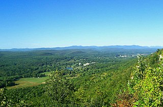
The Catskill Park is in the Catskill Mountains in the U.S. state of New York. It consists of 700,000 acres of land inside a Blue Line in four counties: Delaware, Greene, Sullivan, and Ulster. As of 2005, 287,500 acres (116,300 ha) or 41 percent of the land within, is owned by the state as part of the Forest Preserve; it is managed by the Department of Environmental Conservation (DEC). Another 5% is owned by New York City to protect four of the city's reservoirs in the region that lie partially within the park and their respective watersheds.

<span class="mw-page-title-main">Catskill High Peaks</span> Mountains in New York, United States

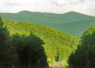
The Catskill High Peaks are all of the mountains in New York's Catskill Mountains above 3,500 ft (1,067 m) in elevation whose summits are separated either by one-half mile (0.8 km) or a vertical drop of at least 250 ft (76.2 m) between it and the next nearest separate summit. By usual standards, these mountains are rather low and rounded, and mostly covered by vegetation.

<span class="mw-page-title-main">Hunter Mountain (New York)</span> Highest mountain in Greene County, New York, and second highest in the Catskills

Hunter Mountain is in the towns of Hunter and Lexington, just south of the village of Hunter, in Greene County, New York, United States. At approximately 4,040 feet (1,231 m) in elevation, it is the highest peak in the county and the second-highest peak in the Catskill Mountains.

<span class="mw-page-title-main">Slide Mountain (Ulster County, New York)</span> Highest peak of New Yorks Catskill Mountains

Slide Mountain is the highest peak in the Catskill Mountains of the U.S. state of New York. It is located in the town of Shandaken in Ulster County. While the 4,180-foot (1,270 m) contour line on topographic maps is generally accepted as its height, the exact elevation of the summit has never been officially determined by the U.S. National Geodetic Survey or its predecessors, and many informal surveys suggest the mountain may actually top 4,200 feet (1,280 m) above sea level.

<span class="mw-page-title-main">Forest Preserve (New York)</span> Areas of New York state where state-owned lands mostly remain "forever wild"

New York's Forest Preserve, comprises almost all the lands owned by the state of New York within the Adirondack and Catskill parks. It is managed by the state Department of Environmental Conservation (DEC).

The Slide Mountain Wilderness Area is, at 47,500 acres (19,200 ha), the largest tract of state-owned Forest Preserve in New York's Catskill Park, and the largest area under any kind of wilderness area protection between the Adirondacks and the southern Appalachians. It is located in the towns of Shandaken, Denning and Olive in Ulster County.

<span class="mw-page-title-main">Kaaterskill High Peak</span> Mountain in United States of America

Kaaterskill High Peak is one of the Catskill Mountains, located in the Town of Hunter in Greene County, New York, United States. It was once believed to be the highest peak in the entire range, but its summit, at 3,655 feet (1,114 m) in elevation, places it only 23rd among the Catskill High Peaks. It is, however, the fourth most prominent peak in the range. Due to its situation as the easternmost High Peak, its summit is just outside the watersheds of New York City's reservoirs in the region.

<span class="mw-page-title-main">Devil's Path (hiking trail)</span> Mountainous hiking trail in New York States Catskill region

The Devil's Path is a hiking trail in the Greene County section of the Catskill Mountains of New York, sometimes described as one of the more challenging trails in the New York Tri-state area. It goes across the eponymous mountain range and then three other peaks to the west, offering hikers and peakbaggers a chance to reach the summits of five of the 35 Catskill High Peaks. It draws hikers from not just the region but far outside, due to the challenging climbs straight up and down the steep gaps between the four peaks of the range, which often require hikers to use hands as well as feet to pull themselves almost straight up cliffs and through rocky chutes. These climbs, however, lead to views across the Catskill range.

<span class="mw-page-title-main">Rusk Mountain</span> Mountain in New York, United States

Rusk Mountain is a peak located in the towns of Jewett and Lexington in Greene County, New York, United States. At 3,680 feet (1,120 m) in elevation, it is the 20th-highest peak in the Catskill Mountains and considered a member of the Catskill High Peaks. While there is no maintained trail, a bushwhack to the summit is considered relatively easy, and required for membership in the Catskill Mountain 3500 Club.

<span class="mw-page-title-main">Panther Mountain (New York)</span> Mountain in New Yorks Catskill range that rose from old meteor crater

Panther Mountain is one of the Catskill High Peaks, located in the Town of Shandaken in Ulster County, New York. At approximately 3,720 feet (1,130 m) in elevation, it is the 18th highest in the range. A combination of factors has led some geologists to believe the mountain is on the site of an ancient meteorite impact crater.

<span class="mw-page-title-main">Hunter Mountain Fire Tower</span> Historic fire lookout tower in New York, United States

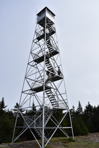
The Hunter Mountain Fire Tower is located on the summit of the eponymous mountain, second highest of the Catskill Mountains in the U.S. state of New York. It was the first of 23 fire lookout towers built by the state in the region, and the next-to-last of the five still standing to be abandoned.

<span class="mw-page-title-main">Halcott Mountain</span> Mountain in the Catskill range in U.S. state of New York

Halcott Mountain is one of the Catskill Mountains of the U.S. state of New York. It is mostly located in Greene County, with some of its lower slopes in Delaware and Ulster counties. Its exact summit elevation has not been officially determined, but the highest contour line on the mountain is 3,520 feet (1,070 m). It is one of the peaks on the divide between the Delaware and Hudson watersheds.

<span class="mw-page-title-main">Southwest Hunter Mountain</span> Mountain in United States of America

Southwest Hunter Mountain (Leavitt Peak) is a subpeak of Hunter Mountain, located in Greene County, New York. It is considered one of the Catskills' High Peaks in its own right, because of its separation from the main summit, and its topographic prominence. Hunter Mountain is named after John Hunter, who also gave his name to the town of Hunter.

<span class="mw-page-title-main">Balsam Mountain (Ulster County, New York)</span> 28th highest peak of Catskill Mountains

Balsam Mountain is one of the High Peaks of the Catskill Mountains in the U.S. state of New York. Its exact height has not been determined, so the highest contour line, 3,600 feet (1,100 m), is usually given as its elevation. It is located in western Ulster County, on the divide between the Hudson and Delaware watersheds. The summit and western slopes of the peak are within the Town of Hardenburgh and its eastern slopes are in Shandaken. The small community of Oliverea is near its base on that side. Most of the mountain is publicly owned, managed by the New York State Department of Environmental Conservation as part of the state Forest Preserve, part of the Big Indian-Beaverkill Range Wilderness Area in the Catskill Park. The summit is on a small corner of private land.

<span class="mw-page-title-main">Balsam Lake Mountain</span> Westernmost of the Catskill High Peaks in U.S. state of New York

Balsam Lake Mountain is one of the Catskill Mountains, located in the Town of Hardenburgh, New York, United States. It is the westernmost of the range's 35 High Peaks. Its exact height has not been determined, but the highest contour line on topographic maps, 3,720 feet (1,130 m), is usually given as its elevation.

<span class="mw-page-title-main">Graham Mountain (New York)</span> Highest privately owned summit in New Yorks Catskill Mountains

Graham Mountain is the seventh highest of the Catskill High Peaks and the highest privately owned mountain in the range. It is located in the town of Hardenburgh, New York, United States.

Rocky Mountain is a mountain located in Ulster County, New York. The mountain is part of the Catskill Mountains. Rocky Mountain is flanked to the west by Lone Mountain, and to the northeast by Balsam Cap.

<span class="mw-page-title-main">Cornell Mountain</span> Mountain located in Ulster County, New York

Cornell Mountain is a mountain located in Ulster County, New York. The mountain is part of the Burroughs Range of the Catskill Mountains. Cornell Mountain is flanked to the northeast by Wittenberg Mountain, to the southwest by Friday Mountain, and to the west by 4,180-foot (1,270 m) Slide Mountain — the highest peak in the Catskills.

<span class="mw-page-title-main">Wittenberg Mountain</span> Mountain in the United States

Wittenberg Mountain, locally "the Wittenberg'', is a mountain in Ulster County, New York. It is part of the Burroughs Range of the Catskill Mountains. Wittenberg is flanked to the southwest by Cornell Mountain and to the northeast by Terrace Mountain.

<span class="mw-page-title-main">Balsam Lake Mountain Fire Observation Station</span> Former fire lookout tower in the Catskill Mountains of New York, USA

The Balsam Lake Mountain Fire Observation Station is located at the summit of the mountain of that name in the Town of Hardenburgh, New York, United States. It comprises a steel frame fire lookout tower, the observer's cabin and privy and the jeep road to the complex.

References

  1. "List Of Members Since Our Foundation". Catskill 3500 Club. May 2020. Retrieved November 30, 2020.