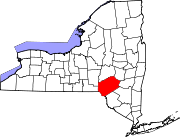
Middletown is a town in Delaware County, New York, United States. The population was 3,336 at the 2020 census. The town is in the southeastern part of the county.

Hardenburgh is a town located in the western part of Ulster County, New York, United States. The population was 221 at the 2020 census. The town is located inside the Catskill Park.

Shandaken is a town on the northern border of Ulster County, New York, United States, northwest of Kingston, New York. As of the 2020 census, the town had a total population of 2,866. The name is believed to be from an Esopus phrase for "land of rapid waters."

Bainbridge is a town in Chenango County, New York, United States. The population was 3,308 at the 2010 census. The town is at the eastern border of Chenango County, halfway between Binghamton and Oneonta.
Andes is a town in Delaware County, New York, United States. The population was 1,114 at the 2020 census.
Bath is a town in Steuben County, New York, United States, with an area of 96.3 square miles and a population of 11,426 in 2020. Its largest settlement is the Village of Bath, which has an area of 2.9 sq mi and a population of 5,641. The Village is the county seat of Steuben County. The Town is located in the central part of the county, northwest of Elmira. The town and village are either named after the city of Bath in England or after Lady Bath, daughter of a landowner.

The Catskill Mountains, also known as the Catskills, are a physiographic province of the larger Appalachian Mountains, located in southeastern New York. As a cultural and geographic region, the Catskills are generally defined as those areas close to or within the borders of the Catskill Park, a 700,000-acre (2,800 km2) forest preserve protected from many forms of development under New York state law.

New York State Route 28 (NY 28) is a state highway extending for 281.69 miles (453.34 km) in the shape of a "C" between the Hudson Valley city of Kingston and southern Warren County in the U.S. state of New York. Along the way, it intersects several major routes, including Interstate 88 (I-88), U.S. Route 20 (US 20), and the New York State Thruway twice. The southern terminus of NY 28 is at NY 32 in Kingston and the northern terminus is at US 9 in Warrensburg. In Kingston, NY 28 is co-designated as Interstate 587 from its southern terminus at NY 32 to the roundabout linking it to the Thruway (I-87).

The Beaver Kill, sometimes written as the Beaverkill or Beaverkill River, is a tributary of the East Branch Delaware River, a main tributary of the Delaware River, approximately 44 miles (71 km) long, in the U.S. state of New York. The kill drains a 300-square-mile (780 km2) area of the Catskill Mountains and has long been celebrated as one of the most famous trout streams in the United States. Its preservation helped establish many of the basic conservation principles of rivers in the United States.

The East Branch Delaware River is one of two branches that form the Delaware River. It is approximately 75 mi (121 km) long, and flows through the U.S. state of New York. It winds through a mountainous area on the southwestern edge of Catskill Park in the Catskill Mountains for most of its course, before joining the West Branch along the northeast border of Pennsylvania with New York. Much of it is paralleled by State Route 30.
The Ulster and Delaware Railroad (U&D) was a railroad located in the state of New York. It was often advertised as "The Only All-Rail Route to the Catskill Mountains." At its greatest extent, the U&D extended 107 miles (172 km) from Kingston Point on the Hudson River through the Catskill Mountains to its western terminus at Oneonta, passing through the counties of Ulster, Delaware, Schoharie and Otsego.
Grand Hotel station, MP 41.4 of the Ulster and Delaware Railroad, was located in the small mountain hamlet of Highmount, New York, at the summit between Big Indian and Arkville. A turntable was located here, allowing pusher engines to be turned before descending to Arkville or Big Indian.
Kelly's Corners station, MP 51.4 on the Ulster and Delaware Railroad, served a rural farming community, which there were plenty of in Delaware County.

Layton is an unincorporated community and census-designated place (CDP) located within Sandyston Township in Sussex County, in the U.S. state of New Jersey. The area is served as United States Postal Service ZIP Code 07851.

New York State Route 206 (NY 206) is a 74.57-mile-long (120.01 km) state highway in the Southern Tier of New York in the United States. It runs through some lightly populated regions along the state's southern border, from Central New York to the Catskills. It begins near a busy intersection with Interstate 81 (I-81) at Whitney Point and runs east from there through Greene. The eastern terminus is located at a junction with NY 17 at Roscoe in Sullivan County. It is one of the longest three-digit routes in New York, and the only long one not associated with a two-digit route or a former U.S. Route. Yet due to its location it sees little traffic, although for much of its length it follows the route of a main 19th century thoroughfare, the Catskill Turnpike. It is primarily detour around Binghamton.
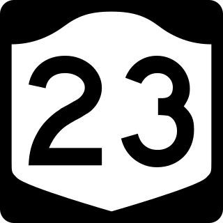
New York State Route 23 (NY 23) is an east–west state highway in the eastern portion of New York in the United States. It extends for 156.15 miles (251.30 km) from an intersection with NY 26 in the Central New York town of Cincinnatus in Cortland County to the Massachusetts state line in the Berkshire Mountains, where it continues east as that state's Route 23. Along the way, it passes through many communities, including the cities of Norwich and Oneonta. Outside of the communities, the route serves largely rural areas of the state and traverses the Catskill Mountains in the state's Central New York Region. NY 23 crosses the Hudson River at Catskill via the Rip Van Winkle Bridge.
The Delaware and Ulster Railroad (DURR) is a heritage railroad based in Arkville, New York.

Halcott Mountain is one of the Catskill Mountains of the U.S. state of New York. It is mostly located in Greene County, with some of its lower slopes in Delaware and Ulster counties. Its exact summit elevation has not been officially determined, but the highest contour line on the mountain is 3,520 feet (1,070 m). It is one of the peaks on the divide between the Delaware and Hudson watersheds.
Big Indian is a hamlet within the Town of Shandaken in Ulster County, New York, United States. It is located along State Route 28, within the Catskill Park, 17 miles (27 km) west of Woodstock. The Esopus Creek flows through the area, as Birch Creek feeds in from the north. Big Indian Hollow is located slightly to the west, while Big Indian Mountain sits to the southwest.

Halcottsville is a hamlet in the town of Middletown, Delaware County, New York, United States, on the south shore of Wawaka Lake. It was named for John Halcott (1758-1831), a Revolutionary War soldier from Delaware County. He resided with his son Thomas in Halcottsville until his demise. Halcottsville is located on the East Branch Delaware River and New York State Route 30 5.6 miles (9.0 km) northeast of Margaretville. Halcottsville has a post office with ZIP code 12438. The hamlet has a stop on the excursion Delaware & Ulster Railroad which originates in nearby Arkville and extends north to the village of Roxbury.