Walton (village), New York

Last updated

Walton, New York
USA New York location map.svg
Red pog.svg
Walton
Location within the state of New York
Coordinates: 42°10′11″N75°7′49″W / 42.16972°N 75.13028°W / 42.16972; -75.13028
CountryUnited States
State New York
County Delaware
Town Walton
Area
[1]
  Total1.60 sq mi (4.15 km2)
  Land1.54 sq mi (3.99 km2)
  Water0.06 sq mi (0.15 km2)
Elevation
1,207 ft (368 m)
Population
 (2020)
  Total2,885
  Density1,870.95/sq mi (722.21/km2)
Time zone UTC-5 (Eastern (EST))
  Summer (DST) UTC-4 (EDT)
ZIP code
13856
Area code 607
FIPS code 36-78036 [2]
GNIS feature ID0970747 [3]
Website villageofwalton.com

Walton is a village in the town of Walton in Delaware County, New York, United States. As of the 2010 census, the village population was 3,088. [4]

Contents

Walton is the home of the annual Delaware County Fair, which is typically held in August. [5]

There are three primary and secondary schools in Walton: Townsend Elementary School, Mack Middle School, and O'Neill High School. [6]

History

The Christ Episcopal Church, First Congregational Church of Walton, Gardiner Place Historic District, U.S. Post Office, and the Walton Grange 1454-Former Armory, all listed on the National Register of Historic Places, are located in the village. [7] [8]

Walton is the birthplace of William B. Ogden (born 15 June 1805), the first mayor of Chicago and a founder of the Chicago & Northwestern Railroad line. [9] [10]

Walton has suffered from major flooding in 1996 and 2006. [11] [12]

Geography

The village is located at the center of the town of Walton, along the West Branch Delaware River. New York State Route 10 passes through the village, leading northeast 16 miles (26 km) to Delhi and southwest 27 miles (43 km) to Deposit. New York State Route 206 joins NY 10 in the village center and leads northwest 23 miles (37 km) to Bainbridge and southeast 10 miles (16 km) to Downsville. It is in close proximity to Agloe, the fictional town created to prevent copyright infringement of a mapping company.

According to the United States Census Bureau, the village of Walton has a total area of 1.6 square miles (4.2 km2), of which 1.5 square miles (4.0 km2) is land and 0.1 square miles (0.2 km2), or 3.73%, is water. [4]

Climate

Climate data for Walton 2, New York, 1991–2020 normals, 1997–2023 extremes: 1480ft (451m)
MonthJanFebMarAprMayJunJulAugSepOctNovDecYear
Record high °F (°C)63
(17)
73
(23)
85
(29)
91
(33)
90
(32)
91
(33)
94
(34)
97
(36)
91
(33)
85
(29)
75
(24)
66
(19)
97
(36)
Mean maximum °F (°C)53.9
(12.2)
54.9
(12.7)
66.0
(18.9)
78.9
(26.1)
85.2
(29.6)
87.7
(30.9)
88.6
(31.4)
87.6
(30.9)
85.0
(29.4)
77.9
(25.5)
67.0
(19.4)
57.0
(13.9)
90.7
(32.6)
Mean daily maximum °F (°C)31.5
(−0.3)
34.2
(1.2)
42.5
(5.8)
55.6
(13.1)
66.8
(19.3)
74.6
(23.7)
78.8
(26.0)
77.7
(25.4)
71.3
(21.8)
59.6
(15.3)
47.2
(8.4)
36.1
(2.3)
56.3
(13.5)
Daily mean °F (°C)21.4
(−5.9)
22.9
(−5.1)
30.8
(−0.7)
43.2
(6.2)
53.7
(12.1)
62.3
(16.8)
66.6
(19.2)
65.7
(18.7)
59.0
(15.0)
47.8
(8.8)
37.0
(2.8)
27.5
(−2.5)
44.8
(7.1)
Mean daily minimum °F (°C)11.4
(−11.4)
11.5
(−11.4)
19.1
(−7.2)
30.8
(−0.7)
40.5
(4.7)
50.1
(10.1)
54.5
(12.5)
53.8
(12.1)
46.7
(8.2)
35.9
(2.2)
26.8
(−2.9)
18.9
(−7.3)
33.3
(0.7)
Mean minimum °F (°C)−10.3
(−23.5)
−7.2
(−21.8)
0.1
(−17.7)
16.7
(−8.5)
25.7
(−3.5)
35.3
(1.8)
43.0
(6.1)
42.4
(5.8)
33.3
(0.7)
23.6
(−4.7)
11.6
(−11.3)
0.4
(−17.6)
−12.9
(−24.9)
Record low °F (°C)−21
(−29)
−21
(−29)
−15
(−26)
6
(−14)
20
(−7)
27
(−3)
29
(−2)
38
(3)
25
(−4)
18
(−8)
−10
(−23)
−17
(−27)
−21
(−29)
Average precipitation inches (mm)3.50
(89)
2.62
(67)
3.52
(89)
4.16
(106)
4.18
(106)
4.96
(126)
4.53
(115)
5.15
(131)
4.63
(118)
4.67
(119)
3.66
(93)
3.56
(90)
49.14
(1,249)
Average snowfall inches (cm)22.1
(56)
22.3
(57)
16.2
(41)
3.2
(8.1)
0.5
(1.3)
0.0
(0.0)
0.0
(0.0)
0.0
(0.0)
0.0
(0.0)
0.8
(2.0)
6.8
(17)
19.9
(51)
91.8
(233.4)
Average precipitation days (≥ 0.01 in)17.113.013.713.315.714.212.713.212.014.814.216.5170.4
Average snowy days (≥ 0.1 in)13107200000141047
Source 1: NOAA [13]
Source 2: XMACIS2 (extremes & 1997-2020 snowfall/days) [14]

Demographics

Historical population
CensusPop.Note
1870 866
1880 1,38960.4%
1890 2,29965.5%
1900 2,81122.3%
1910 3,10310.4%
1920 3,59816.0%
1930 3,496−2.8%
1940 3,6975.7%
1950 3,9476.8%
1960 3,855−2.3%
1970 3,744−2.9%
1980 3,329−11.1%
1990 3,326−0.1%
2000 3,070−7.7%
2010 3,0880.6%
2020 2,885−6.6%
U.S. Decennial Census [15]

As of the census [2] of 2000, there were 3,070 people, 1,366 households, and 818 families residing in the village. The population density was 1,945.2 inhabitants per square mile (751.0/km2). There were 1,514 housing units at an average density of 959.3 per square mile (370.4/km2). The racial makeup of the village was 97.92% White, 0.33% Black or African American, 0.39% Native American, 0.33% Asian, 0.13% from other races, and 0.91% from two or more races. Hispanic or Latino of any race were 1.37% of the population.

There were 1,366 households, out of which 28.6% had children under the age of 18 living with them, 42.2% were married couples living together, 13.8% had a female householder with no husband present, and 40.1% were non-families. 34.9% of all households were made up of individuals, and 16.2% had someone living alone who was 65 years of age or older. The average household size was 2.22 and the average family size was 2.83.

In the village, the population was spread out, with 24.2% under the age of 18, 6.7% from 18 to 24, 26.1% from 25 to 44, 23.5% from 45 to 64, and 19.4% who were 65 years of age or older. The median age was 41 years. For every 100 females, there were 87.5 males. For every 100 females age 18 and over, there were 83.8 males.

The median income for a household in the village was $26,550, and the median income for a family was $40,122. Males had a median income of $26,744 versus $19,839 for females. The per capita income for the village was $16,269. About 8.0% of families and 12.4% of the population were below the poverty line, including 11.0% of those under age 18 and 11.1% of those age 65 or over.

Notable people

Media

Related Research Articles

<span class="mw-page-title-main">Lyman, Maine</span> Town in the state of Maine, United States

Lyman is a town in York County, Maine, United States. The population was 4,525 at the 2020 census. It is part of the Portland–South Portland–Biddeford, Maine metropolitan statistical area. Lyman, together with Alfred, is home to Massabesic Experimental Forest.

<span class="mw-page-title-main">Sanford, New York</span> Town in New York, United States

Sanford is a town in Broome County, New York, United States. The population was 2,407 at the 2010 census.

<span class="mw-page-title-main">Whitney Point, New York</span> Village in New York, United States

Whitney Point is a village in Broome County, New York, United States. The population was 964 at the 2010 census. It is part of the Binghamton Metropolitan Statistical Area. The name comes from Thomas and William Whitney, early developers.

Hamden is a town in Delaware County, New York, United States. The population was 1,323 at the 2010 census.

Harpersfield is a town in Delaware County, New York, United States. The population was 1,577 at the 2010 census. The town is on the northern border of the county.

<span class="mw-page-title-main">Margaretville, New York</span> Village in New York, United States

Margaretville is a village in Delaware County, New York, United States. The population was 596 at the 2010 census. The village is in the town of Middletown, on the border of the Catskill Park.

<span class="mw-page-title-main">Parma, New York</span> Town in New York, United States

Parma is a town in Monroe County, New York, United States. The population was 16,217 at the 2020 census.

<span class="mw-page-title-main">Greenwood Lake, New York</span> Village in New York, United States

Greenwood Lake is a village in Orange County, New York, United States, in the southern part of the town of Warwick. As of the 2020 census, the population of the village was 2,994. It is part of the Poughkeepsie–Newburgh–Middletown, NY Metropolitan Statistical Area as well as the larger New York–Newark–Bridgeport Combined Statistical Area.

<span class="mw-page-title-main">Palermo, New York</span> Town in New York, United States

Palermo is a town in Oswego County in the U.S. state of New York. The population was 3,664 at the 2010 census. The town is named after Palermo in Sicily.

<span class="mw-page-title-main">Pittsfield, New York</span> Town in New York, United States

Pittsfield is a town in Otsego County, New York, United States. The population was 1,366 at the 2010 census.

<span class="mw-page-title-main">Gilboa, New York</span> Town in New York, United States

Gilboa is a town in Schoharie County, New York, United States. The population was 1,111 at the 2020 census.

Berkshire is a town in Tioga County, New York, United States. As of the 2020 census, it had a population of 1,485. The town is named after Berkshire County, Massachusetts.

Delhi is a village in Delaware County, New York, United States. The population was 3,087 at the 2010 census. Delhi is the county seat of Delaware County.

<span class="mw-page-title-main">Delhi, New York</span> Town in New York, United States

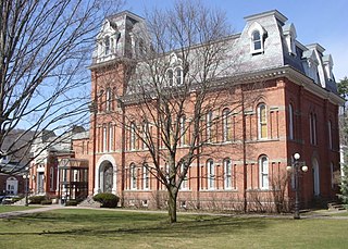
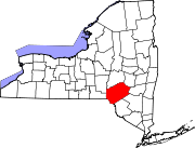
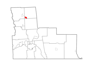
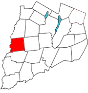
Delhi is a town in Delaware County, New York, United States. The population was 4,795 at the 2020 census. The town is in the east-central part of the county and contains the village of Delhi. The State University of New York at Delhi is located in the town.

<span class="mw-page-title-main">Hancock (village), New York</span> Village in New York, United States

Hancock is a village in Delaware County, New York, United States. The population was 908 at the 2020 census. The village is in the west part of the town of Hancock at the junction of NY Routes 17 and 97.

<span class="mw-page-title-main">Hancock, New York</span> Town in New York, United States

Hancock is a town in Delaware County, New York, United States. The town contains a village, also named Hancock. The town is in the southwest part of the county. The population was 3,224 at the 2010 census. The town is the largest by area in Delaware County. The town borders two other counties, Sullivan County, NY, to the south and Wayne County, PA, to the west. The town is located partially in the Catskill Park.

<span class="mw-page-title-main">Stamford (village), New York</span> Village in New York, United States

Stamford is a village in Delaware County, New York, United States. The population was 1,119 at the 2010 census. The village is located partly in the town of Stamford and partly in the town of Harpersfield. The village is on routes 23 and 10. The village has termed itself the "Queen of the Catskills".

<span class="mw-page-title-main">Walton (town), New York</span> Town in New York, United States

Walton is a town in Delaware County, New York, United States. The population was 5,576 at the 2010 census. The town is in the west-central part of the county and contains the village of Walton. The town claims to be the "Scarecrow Capital of the World."

Waddington is a town in St. Lawrence County, New York, United States. The population was 2,266 at the 2010 census. The town was named after its principal village.

Deposit is a town in Delaware County, New York, United States. As of the 2010 census, the town's population was 1,712.

References

  1. "ArcGIS REST Services Directory". United States Census Bureau. Retrieved September 20, 2022.
  2. 1 2 "U.S. Census website". United States Census Bureau . Retrieved January 31, 2008.
  3. "US Board on Geographic Names". United States Geological Survey. October 25, 2007. Retrieved January 31, 2008.
  4. 1 2 "Geographic Identifiers: 2010 Demographic Profile Data (G001): Walton village, New York". U.S. Census Bureau, American Factfinder. Archived from the original on February 13, 2020. Retrieved November 10, 2015.
  5. "Delaware County Fair - Walton, NY". Delaware County Fair - Walton, NY.
  6. "Walton Central School District". www.waltoncsd.org.
  7. "National Register Information System". National Register of Historic Places . National Park Service. March 13, 2009.
  8. "National Register of Historic Places". Weekly List of Actions Taken on Properties: 7/27/15 through 7/31/15. National Park Service. August 7, 2015.
  9. Downard, William L. "William Butler Ogden and the Growth of Chicago," Journal of the Illinois State Historical Society, Spring 1982 (vol. 75, no. 1) pp. 47-60. http://dig.lib.niu.edu/ISHS/ishs-1982spring/ishs-1982spring.html
  10. Harpster, Jack. (2009) The Railroad Tycoon Who Built Chicago: A Biography of William B. Ogden. Carbondale, Ill.: Southern Illinois University Press http://ogdenbooks.jackharpster.com/william_ogden.htm
  11. Revkin, Andrew C. (January 22, 1996). "THE FLOODING AFTER THE STORM: THE IMPACT;In 2 Neighboring Towns, an Angry River and Sudden Death for Five". The New York Times.
  12. "flood 2006 | Town of Walton, NY". townofwalton.org.
  13. "Walton 2, New York 1991-2020 Monthly Normals" . Retrieved March 22, 2024.
  14. "xmACIS". National Oceanic and Atmospheric Administration. Retrieved March 22, 2024.
  15. "Census of Population and Housing". Census.gov. Retrieved June 4, 2015.
  16. "William B. Ogden Free Library".
  17. "History | Town of Walton, NY".
  18. "City Readers".
  19. "Harvesting Murder". IMDb . July 13, 2014.
  20. "School Violence1992-1993".
  21. Celis 3d, William (April 21, 1993). "Suburban and Rural Schools Learning That Violence Isn't Confined to the Cities". The New York Times.{{cite news}}: CS1 maint: numeric names: authors list (link)
  22. Celis 3d, William (April 21, 1993). "Suburban and Rural Schools Learning That Violence Isn't Confined to the Cities". The New York Times.{{cite news}}: CS1 maint: numeric names: authors list (link)
  23. "The Daily Gazette - Google News Archive Search".