
Algonquin Peak is a mountain in the MacIntyre Range of the Adirondacks in the U.S. state of New York. It is the second highest mountain in New York, with an elevation of 5,114 feet (1,559 m), and one of the 46 Adirondack High Peaks. It is located in the town of North Elba in Essex County and in the High Peaks Wilderness Area of Adirondack Park. The first recorded ascent of the mountain was made on August 8, 1837, by a party led by New York state geologist Ebenezer Emmons. It was originally named Mount McIntyre, after Archibald McIntyre, but this name was eventually applied to the entire range. Surveyor Verplanck Colvin added the name "Algonquin" in 1880. This name came from the peak reputedly being on the Algonquian side of a nearby informal boundary between the Algonquian and their Iroquois neighbors, although no such boundary existed in reality.
Dix Mountain is a mountain in the Dix Range of the Adirondacks in the U.S. state of New York. With an elevation of 4,857 feet (1,480 m), it is the sixth highest peak in New York and one of the 46 High Peaks of the Adirondack Park. It is located roughly on the boundary between the towns of North Hudson and Keene in Essex County. The crest of the peak consists of a very narrow ridge, which continues to the southeast and rises to a subsidiary peak named Beckhorn, then continues south to other peaks of the Dix Range. The summit is also in an alpine zone above the treeline. The ridge offers unobstructed views of Elk Lake to the southwest, the Great Range to the northwest, and Lake Champlain and the Green Mountains to the east.

Mount Abraham is a mountain in the Green Mountains in the U.S. state of Vermont. Located in the Green Mountain National Forest, its summit is in the town of Lincoln in Addison County, but its eastern slopes extend into the town of Warren in Washington County. The mountain is named after Abraham Lincoln, former president of the United States. It is one of five peaks in Vermont's Presidential Range.
Mount Whiteface is a 4,019 ft (1,225 m) mountain located in Grafton County, New Hampshire. The mountain is part of the Sandwich Range of the White Mountains. Whiteface is flanked to the northwest by Mount Tripyramid, and to the northeast by Mount Passaconaway. Whiteface is on the eastern border of the Sandwich Range Wilderness. To the east, between Whiteface, Passaconaway, and Mt. Wonalancet, lies The Bowl natural area, an unlogged cirque.

Giant Mountain, also known as Giant of the Valley, is a mountain in the Adirondacks in the U.S. state of New York. It is the twelfth-highest peak in New York, with an elevation of 4,627 feet (1,410 m), and one of the 46 High Peaks in Adirondack Park. It is located in the Giant Mountain Wilderness Area, in the town of Keene in Essex County. The mountain is named for its towering appearance from the nearby Pleasant Valley to the east, which sits at a low elevation.

Jay Peak is a mountain located about 5 miles (8.0 km) south of the Canada–US border, in Jay and Westfield, Orleans County, Vermont, of which it is the highest point. Most of the mountain is in Jay State Forest. The mountain is named for the town of Jay, Vermont, in which much of the mountain except the peak area itself is located.

Hough Peak is a mountain located in Essex County, New York. The mountain, part of the Dix Range, is named after Franklin B. Hough (1822–1885), the first chief of the United States Division of Forestry, and sometimes called the "father of American forestry". Hough Peak is flanked to the north by Dix Mountain, and to the south by South Dix.

Phelps Mountain is a mountain located in Essex County, New York. The mountain is named after Orson Schofield "Old Mountain" Phelps (1817–1905), who cut the first trail up Mount Marcy and named several of the Adirondack peaks. It is the 32nd highest peak in New York. Phelps Mountain is flanked to the southeast by Table Top Mountain.
Table Top Mountain is a mountain located in Essex County in the U.S. State of New York. Table Top Mtn. is flanked to the north by Phelps Mountain, and to the south by Mount Marcy. Table Top has three summits; the southernmost is the highest, followed by the middle peak at 4,308 ft (1,313 m) and the north peak at 4,216 ft (1,285 m).

Allen Mountain is located in Essex County, New York. It is part of the Marcy Group of the Great Range of the Adirondack Mountains, and is flanked to the north by Mount Skylight.
Armstrong Mountain is a mountain located in Essex County, New York, named after Thomas Armstrong, a local pioneer. The mountain is part of the Great Range of the Adirondack Mountains. Armstrong Mtn. is flanked to the southwest by Gothics, and to the northeast by Upper Wolfjaw Mountain.
Saddleback Mountain is a mountain located in Essex County, New York. The mountain is part of the Great Range of the Adirondack Mountains. The 0.2 mi (0.32 km) long summit ridge has peaks at each end with a pronounced dip between, giving it the profile of a saddle. Saddleback Mtn. is flanked to the southwest by Basin Mountain, and to the east by Gothics.

Sawteeth is a mountain located in Essex County, New York. The mountain is part of the Great Range of the Adirondack Mountains. The mountain's name comes from the serrated appearance of its summit ridge. Sawteeth is on a spur ridge of the Great Range, which branches off to the southeast from Gothics.

Lower Wolfjaw Mountain is located in Essex County, New York, United States. Landscape artist Alexander Helwig Wyant (1836–1892) named Lower Wolfjaw, together with neighboring Upper Wolfjaw Mountain, about 1870 for their appearance in profile. The mountain is the northeasternmost of the Adirondack High Peaks in the Great Range of the Adirondack Mountains. Lower Wolfjaw Mountain is flanked to the southwest by Upper Wolfjaw Mountain, and to the northeast by Hedgehog Mountain.

Santanoni Peak is a mountain located in the Santanoni Range of the Adirondacks in the U.S. state of New York. It is the fourteenth-highest peak in New York, with an elevation of 4,607 ft (1,404 m), and one of the 46 High Peaks in Adirondack Park. It is located in the town of Newcomb in Essex County. Santanoni Peak is flanked to the north by Panther Peak and to the northwest by Couchsachraga Peak, the other two mountains of the Santanoni Range. The mountain's name is believed to be an Abenaki derivative of "Saint Anthony"; the first French fur traders and missionaries having named the area for Saint Anthony of Padua. Two hiking approaches exist to the summit, which allow the mountain to be climbed in a loop with the other peaks of the range. Beginning at a parking lot near the Upper Works trailhead, the Duck Hole via Bradley Pond Trail approaches the mountains. Both approaches to Santanoni Peak branch off of this trail.
Seward Mountain is a mountain located in Franklin County, New York, of which it is the highest point. Seward Mtn. is named after William H. Seward (1801–1872), Governor of New York (1839–1842), and United States Secretary of State (1861–1869). The mountain is part of the Seward Mountains of the Adirondacks. Seward Mountain is flanked to the southwest by Donaldson Mountain, and to the east faces Seymour Mountain across Ouluska Pass.
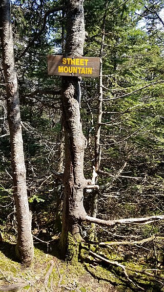
Street Mountain is a mountain located in Essex County, New York, named after Alfred Billings Street (1811–1881), a poet and New York State Librarian. The mountain is the high point of the Street Range of the Adirondack Mountains. Street's northeast ridge is Nye Mountain.

Lyon Mountain is a 3,820 ft (1,160 m) mountain located in Clinton County, New York, the county’s high point. It is named for Nathaniel Lyon, an early settler of the area who moved from Vermont in 1803 and died circa 1850. The mountain is within New York's Adirondack Park.
Bolton Mountain is a mountain located in Chittenden County, Vermont. Bolton is flanked to the north by Mount Mayo.
McKenzie Mountain is a 3,861-foot (1,177 m) mountain in western Essex County in the towns of St. Armand and North Elba in the Adirondack Park, a unit of the Forest Preserve.


