Somerset Hills

Last updated
The Somerset Hills is the northern region of Somerset County, New Jersey including the townships of Bedminster, Bernards Township, Bernardsville, Far Hills boro, and Peapack & Gladstone. Somerset Hills NJ 035.png
The Somerset Hills is the northern region of Somerset County, New Jersey including the townships of Bedminster, Bernards Township, Bernardsville, Far Hills boro, and Peapack & Gladstone.

The Somerset Hills is known as the northern region of Somerset County located in the U.S. state of New Jersey and includes the municipalities of Bedminster, Bernardsville, Bernards Township, Far Hills, and Peapack-Gladstone. [1] The southwestern Morris County municipalities of the Chesters (Borough and Township) and the Mendhams (Borough and Township) are periodically recognized as part of the Somerset Hills. [2] [3] [4]

Contents

The Somerset Hills is in the northern section of Somerset County that was created on May 14, 1688, from portions of Middlesex County. [5]

The term was coined in the early 1800s and references the 2nd Watchung Mountain which crosses Bedminster as well as the Bernardsville Mountain that is the highest mountain in the region. [6]

Geography

The Somerset Hills region is located between two historic centers: Somerville (located on the Raritan River) to the south and Morristown to the north. Each serves as the county seat for Somerset County and Morris County. Both communities feature commercial centers and industrial areas and can be reached via Interstate 287. [7]

The high point in the Somerset Hills is on Mine Mountain in Bernardsville, at approximately 860 feet (260 m) above sea level. [8]

Adjacent municipalities

Somerset Hills contains the following municipalities:

Adjacent counties

Somerset County borders the following counties: [9]

Climate and weather

In recent years, average temperatures in the county seat of Somerville have ranged from a low of 18 °F (−8 °C) in January to a high of 85 °F (29 °C) in July, although a record low of −16 °F (−27 °C) was recorded in January 1984 and a record high of 105 °F (41 °C) was recorded in August 1955. Average monthly precipitation ranged from 2.84 inches (72 mm) in February to 4.83 inches (123 mm) in July. The county has a humid continental climate which is hot-summer (Dfa) except on Mine Mountain west of Bernardsville where it is warm-summer (Dfb).

History

The Somerset Hills is the northern section of Somerset County, New Jersey and is part of one of America's oldest counties and is named after the English county of Somerset. Most of the early residents were Dutch, Scottish and German. General George Washington and his troops marched through the area on several occasions and slept in many of the homes located throughout the area.

For much of its history, the Somerset Hills area was primarily an agricultural county. In the late 19th century, the Somerset Hills area became a popular country home location for wealthy industrialists. The area is still the home of wealthy pharmaceutical industrialists. [10]

In the 1960s, townships that were once exclusively agricultural were quickly transformed into suburban communities. This growth was aided by the development of the county's very strong pharmaceutical and technology presence. More recently, there has been an influx of New York City commuters who use NJ Transit's Gladstone Branch or use Interstate 78.

Historic events

The Somerset Hills played host to a number of events that changed the course of history in the United States. The area hosted three winter encampments for the Continental Army during the Revolutionary War. The first was in 1776 in nearby Bernardsville and Morristown, and the other two were winter encampments in nearby Middlebrook. During the winter of 1778-1779 General Henry Knox and over 1000 artillery troops spent the winter in Pluckemin, New Jersey at what is now known as America's First Military Academy, created 28 years before the founding of the US Military Academy at West Point. Another notable events was the capture of General Charles Lee at the Widow White's tavern in Basking Ridge on December 13, 1776. If it were not for this capture, Lee might have been selected the "father of our country."

In 1779, General Washington wrote General William Alexander, the Earl of Stirling to construct a series of signal beacons to warn the continental army if there was detected movement of the British troops moving west from New York City and Staten Island. This chain of beacons proved effective during the battle of Springfield. These Rev War beacons were remembered during the 225th anniversary of the British Evacuation day on November 25, 2008.

Historic landmarks

The Pluckemin Cantonment was built by the artillery forces for General Henry Knox during the winter of 1778-1779 in the village of Pluckemin (Bedminster, New Jersey). The drawing is referred to the John Lillie drawing and is in possession of the National Park Service in Morristown, New Jersey Pluckemin Academy.jpg
The Pluckemin Cantonment was built by the artillery forces for General Henry Knox during the winter of 1778-1779 in the village of Pluckemin (Bedminster, New Jersey). The drawing is referred to the John Lillie drawing and is in possession of the National Park Service in Morristown, New Jersey

The northern section of Somerset County in the Somerset Hills is rich in history dating back prior to the Revolutionary War.

Parks and recreation

Somerset County parks include Lord Stirling Park (part of the Great Swamp National Wildlife Refuge), the Environmental Education Commission and the region is one of the largest equestrian areas in the United States. Home to the United States Equestrian Team Foundation next to the Hamilton Farm Golf Club, the area has one of the oldest fox hunting organizations, the Essex Hunt Club in Peapack, New Jersey.

Trump National Golf Club in Bedminster is an exclusive golf club owned by Donald Trump. [11] The facility has also served as the 45th President's Summer Whitehouse. Two other golf clubs are the Somerset Hills Country Club in Bernardsville, and Fiddlers Elbow Country Club in Bedminster, New Jersey. The United States Golfing Association (USGA) and museum is also located in Bernards Township, New Jersey.

One of the largest equestrian events in the United States is the Far Hills Race Meeting held annually in Far Hills, New Jersey. Known also as "The Hunt" it is one of the most prestigious steeplechase races in the United States. It is also one of the largest events in the county as the borough grows to over 25,000 (5th largest city in New Jersey) on the October Saturday. In 2020, the FHRM will celebrate its 100th running.

Government

The Somerset Hills Region of Northern Somerset County, New Jersey Map Somerset Hills.jpg
The Somerset Hills Region of Northern Somerset County, New Jersey

While part of Somerset County, each of the Somerset Hills townships are governed by their own separate government bodies. However, there are a number of shared government services that are shared between townships in the Somerset Hills. Somerset County is governed by a five-member Board of Chosen Freeholders, whose members are elected at-large to three-year terms of office on a staggered basis, with one or two seats coming up for election each year. At the federal level, the towns are all located within New Jersey's 7th congressional district, currently represented by Republican Tom Kean, Jr.

Education

Townships within the Somerset Hills are overseen by individual public schools for elementary thru middle school. The Somerset Hills area is home to two public high schools:

Municipalities

Municipalities in the Somerset Hills (with 2010 Census data for population, housing units and area) are listed below. [12]

MunicipalityMun.
type
Pop.Housing
Units
Total
Area
Water
Area
Land
Area
Pop.
Density
Housing
Density
School
District
Communities [13]
Bedminster
Township
Township8,1654,34926.300.2226.08313.1166.8 Somerset Hills (9-12) (S/R)
Bedminster Township (PK-8)
Lamington

Larger Cross

Lesser Cross
Pluckemin
Pottersville

Bernards
Township
Township26,65210,10324.060.1323.931,113.6422.1 Bernards Township Basking Ridge

Franklin Corners
Liberty Corner
Lyons

Madisonville

W. Millington

Bernardsville Borough7,7072,87112.980.0812.91597.2222.5 Somerset Hills
Far Hills Borough9194184.880.084.80191.687.1 Somerset Hills
Peapack-Gladstone Borough2,5829495.850.045.81444.5163.4 Somerset Hills Gladstone

Transportation

Roads and highways

The Somerset Hills area is served by a number of different routes. U.S. Routes include U.S. Route 202 and U.S. Route 206. The two Interstates that pass through are Interstate 78 and Interstate 287.

Public transportation

Bernardsville station Bernardsville Station NJ.JPG
Bernardsville station

NJ Transit provides train service on the Gladstone Branch [14] Public bus transportation is provided by several transit agencies. [15]

NJ Transit provides bus service to the Port Authority Bus Terminal in Midtown Manhattan, as well as service to major cities in New Jersey and within Somerset County. [16] Ridewise provides three SCOOT shuttles [17] as well as DASH buses and CAT buses. [18] [19]

Airports

There three closest airports are the Somerset Airport (small plane) in Bedminster, Morristown Municipal Airport (Mid) and Newark Liberty International Airport in Newark / Elizabeth

Related Research Articles

<span class="mw-page-title-main">Somerset County, New Jersey</span> County in New Jersey, United States

Somerset County is a county located in the north-central part of the U.S. state of New Jersey. As of the 2020 census, the county was the state's 13th-most-populous county, with a population of 345,361, its highest decennial count ever and an increase of 21,917 (+6.8%) from the 2010 census count of 323,444. Somerset County constitutes part of the New York metropolitan area. Its county seat is Somerville. The most populous place in the county was Franklin Township, with 68,364 residents at the time of the 2020 census, while Hillsborough Township, with 55.00 square miles (142.4 km2), covered the largest total area of any municipality. The county is part of the Central Jersey region of the state.

<span class="mw-page-title-main">Mendham Borough, New Jersey</span> Borough in Morris County, New Jersey, US

Mendham Borough is a borough in southwestern Morris County, in the U.S. state of New Jersey. As of the 2020 United States census, the borough's population was 4,981, unchanged from the 2010 census, which in turn reflected a decline of 116 (−2.3%) from the 5,097 counted in the 2000 census. Located in the Raritan Valley region within the New York Metropolitan area, the North Branch of the Raritan River begins in Mendham Borough and flows in a southwest direction towards neighboring Somerset County.

<span class="mw-page-title-main">Mendham Township, New Jersey</span> Township in Morris County, New Jersey, US

Mendham Township is a township in southwestern Morris County, in the U.S. state of New Jersey, located more than 30 miles (48 km) due west of New York City. As of the 2020 United States census, the township's population was 6,016, an increase of 147 (+2.5%) from the 2010 census count of 5,869, which in turn reflected an increase of 469 (+8.7%) from the 5,400 counted in the 2000 census.

<span class="mw-page-title-main">Bedminster, New Jersey</span> Township in Somerset County, New Jersey, US

Bedminster is a township in Somerset County, in the U.S. state of New Jersey. As of the 2020 United States census, the township's population was 8,272, an increase of 107 (+1.3%) from the 2010 census count of 8,165, which in turn reflected a decline of 137 (−1.7%) from the 8,302 counted in the 2000 census. Located within the Raritan Valley region, Bedminster is part of the Somerset Hills of northern Somerset County, bordering both Hunterdon and Morris counties.

<span class="mw-page-title-main">Bernards Township, New Jersey</span> Township in Somerset County, New Jersey, US

Bernards Township is a township in Somerset County, in the U.S. state of New Jersey. As of the 2020 United States census, the township's population was 27,830, an increase of 1,178 (+4.4%) from the 2010 census count of 26,652, reflecting an increase of 2,077 (+8.5%) from the 24,575 counted in the 2000 census.

<span class="mw-page-title-main">Bernardsville, New Jersey</span> Borough in Somerset County, New Jersey, US

Bernardsville is the northernmost borough in Somerset County, in the U.S. state of New Jersey. Situated in the heart of the Raritan Valley region, the borough is part of the Somerset Hills. As of the 2020 United States census, the borough's population was 7,893, an increase of 186 (+2.4%) from the 2010 census count of 7,707, which in turn reflected an increase of 362 (+4.9%) from the 7,345 counted in the 2000 census. Bernardsville is often mispronounced as "Ber-NARDS-ville" as opposed to the correct pronunciation "BER-nards-ville".

<span class="mw-page-title-main">Far Hills, New Jersey</span> Borough in Somerset County, New Jersey, US

Far Hills is a borough in the Somerset Hills of northern Somerset County in the U.S. state of New Jersey. As of the 2020 United States census, the borough's population was 924, an increase of 5 (+0.5%) from the 2010 census count of 919, which in turn reflected an increase of 60 (+7.0%) from the 859 counted in the 2000 census. The borough is located within the Raritan Valley region.

<span class="mw-page-title-main">Peapack-Gladstone, New Jersey</span> Borough in Somerset County, New Jersey, US

Peapack-Gladstone is a borough in the Somerset Hills region of northern Somerset County in the U.S. state of New Jersey. As of the 2020 United States census, the borough's population was 2,558, a decrease of 24 (−0.9%) from the 2010 census count of 2,582, which in turn reflected an increase of 149 (+6.1%) from the 2,433 counted in the 2000 census.

<span class="mw-page-title-main">Gladstone, New Jersey</span> Place in Somerset County, New Jersey, United States

Gladstone is an unincorporated community located within Peapack-Gladstone in Somerset County, in the U.S. state of New Jersey. The area is served as United States Postal Service ZIP Code 07934. Gladstone was named in honor of William Ewart Gladstone, who served as British Prime Minister several times between 1868 and 1894.

<span class="mw-page-title-main">Gladstone Branch</span> Commuter rail line in New Jersey

The Gladstone Branch is a commuter rail line operated by NJ Transit from Gladstone station, in the U.S. state of New Jersey, to either Hoboken Terminal or New York Penn Station. It is one of two branches of the Morris & Essex Lines.

<span class="mw-page-title-main">Natirar</span> New Jersey estate and park

Natirar is an estate spanning 491 acres (1.99 km2) in Peapack-Gladstone, Far Hills and Bedminster, in Somerset County, New Jersey, United States. Its name is a reverse spelling of Raritan. The complex was built between 1910 and 1912. In 2003 it was sold by the estate of Hassan II, late King of Morocco, to Somerset County, New Jersey, and is now administered by the Somerset County Park Commission. Approximately 90 acres (360,000 m2) of the estate have been leased to develop that portion of the estate into an exclusive hotel, spa, restaurant complex.

<span class="mw-page-title-main">Basking Ridge, New Jersey</span> Populated place in Somerset County, New Jersey, US

Basking Ridge is an unincorporated community and census-designated place (CDP) located within Bernards Township in the Somerset Hills region of Somerset County, in the U.S. state of New Jersey.

The Somerset Hills Regional School District is a comprehensive regional public school district serving students in pre-kindergarten through twelfth grade from four communities in Somerset County, in the U.S. state of New Jersey. The district serves students from the boroughs of Bernardsville, Far Hills and Peapack-Gladstone, along with students from the township of Bedminster who attend the district's high school as part of a sending/receiving relationship.

<span class="mw-page-title-main">Far Hills station</span> NJ Transit rail station

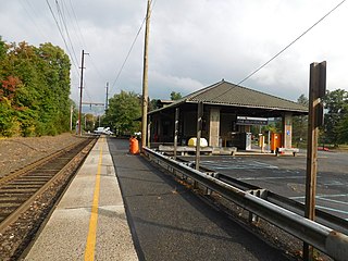
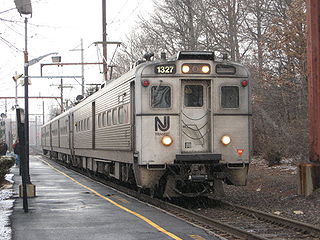
Far Hills is a NJ Transit station in Far Hills, in Somerset County, New Jersey, United States located at the intersection of Route 202 and CR 512, one-half mile (0.80 km) east of Route 206.

<span class="mw-page-title-main">Ridge High School</span> High school in Somerset County, New Jersey, United States

Ridge High School is a four-year comprehensive community public high school serving students in ninth through twelfth grades from Bernards Township in Somerset County, in the U.S. state of New Jersey, operating as the lone secondary school of the Bernards Township School District.

<span class="mw-page-title-main">Lyons station</span> NJ Transit rail station

Lyons is a New Jersey Transit station in Basking Ridge, New Jersey along the Gladstone Branch of the Morris & Essex Lines. The station serves south Basking Ridge as well as the Hills and Liberty Corner.

<span class="mw-page-title-main">County Route 512 (New Jersey)</span> County highway in New Jersey, U.S.

County Route 512 is a county highway in the U.S. state of New Jersey. The highway extends 32.96 miles (53.04 km) from High Bridge Road in Califon to Springfield Avenue / Route 24 in Summit.

The Bedminster Township School District is a community public school district that serves students in pre-kindergarten through eighth grade from Bedminster, in Somerset County, in the U.S. state of New Jersey.

The Hills is a planned community and census-designated place (CDP) in Bedminster and Bernards townships, Somerset County, in the U.S. state of New Jersey. It was first listed as a CDP in the 2020 census.

References

  1. About Us, Historical Society of the Somerset Hills. Accessed June 23, 2023. "Founded in 1928 originally as the Historical Society of Basking Ridge, the mission and name of the society was later changed to The Historical Society of the Somerset Hills, a 501 (c) (3) non-profit organization including all five communities of the Somerset Hills region: Bedminster Township, Bernards Township, Bernardsville, Far Hills, and Peapack-Gladstone, which are all located in Somerset County, New Jersey."
  2. https://somersethillshistoricalsociety.org/wp-content/uploads/2021/06/Newsletter-May2021-1.pdf
  3. "Review: New Jersey Country Homes The Somerset Hills." T3 Consortium, LLC, last modified September 2006, backed up by the Internet Archive as of July 24, 2008. Accessed December 11, 2015.
  4. Explore Southwestern Morris County, Morris County Tourism Authority. Accessed April 10, 2024. "Southwestern Morris County includes a multitude of farms, farmers markets and community-supported agriculture offering fresh produce and festivals throughout the growing season throughout its communities of Mount Olive, Washington Township (Long Valley), Roxbury, Chester, Chester Township, Mount Arlington, Mendham, Mendham Township, Randolph and Netcong."
  5. Snyder, John P. The Story of New Jersey's Civil Boundaries: 1606-1968, Bureau of Geology and Topography; Trenton, New Jersey; 1969. p. 221. Accessed October 30, 2012.
  6. "Second Watchung Mountain". Topozone.
  7. https://www.bernardsvilleboro.org/meetings/master-plans/664-comprehensive-master-plan-amended-2004/file
  8. New Jersey County High Points, Peakbagger.com. Accessed October 1, 2013.
  9. Areas touching Somerset County, MapIt. Accessed January 19, 2015.
  10. Clemence, Sara. "Home of the Week: Peapack Palace", Forbes , March 14, 2005. Accessed May 22, 2008. "It was once the country home of some of the 19th century's wealthiest families, and modern-day residents now include pharmaceuticals and chemicals barons."
  11. Welcome, Trump National Golf Club. Accessed October 6, 2013. "Greetings from Donald J. Trump: When I saw this beautiful piece of property in Bedminster, New Jersey, I knew that it deserved only the best."
  12. GCT-PH1: Population, Housing Units, Area, and Density: 2010 - County -- County Subdivision and Place from the 2010 Census Summary File 1 for Somerset County, New Jersey, United States Census Bureau. Accessed May 14, 2015.
  13. Locality Search, State of New Jersey. Accessed May 11, 2015.
  14. Gladstone Branch Raritan Valley Line, NJ Transit. Accessed October 6, 2013.
  15. Transportation Services Archived August 29, 2014, at the Wayback Machine , Somerset County, New Jersey. Accessed October 1, 2013.
  16. Somerset County Bus / Rail Connections, NJ Transit, backed up by the Internet Archive as of May 22, 2009. Accessed October 6, 2013.
  17. Scoot, Ridewise. Accessed October 1, 2013.
  18. DASH, Ridewise. Accessed October 1, 2013.
  19. CAT, Ridewise. Accessed January 19, 2015.