Pottersville, New Jersey

Last updated

Pottersville, New Jersey
Pottersville Reformed Church, Pottersville, NJ.jpg
Pottersville Reformed Church
Location map of Hunterdon County, New Jersey.svg
Red pog.svg
Pottersville
Location in Hunterdon County
Location map of Somerset County, New Jersey.svg
Red pog.svg
Pottersville
Location in Somerset County
USA New Jersey relief location map.svg
Red pog.svg
Pottersville
Location in New Jersey
Usa edcp relief location map.png
Red pog.svg
Pottersville
Location in the United States
Coordinates: 40°42′49″N74°43′19″W / 40.71361°N 74.72194°W / 40.71361; -74.72194
Country Flag of the United States.svg  United States
State Flag of New Jersey.svg  New Jersey
County Hunterdon and Somerset
Township Bedminster and Tewksbury
Area
[1]
  Total0.92 sq mi (2.38 km2)
  Land0.91 sq mi (2.36 km2)
  Water0.01 sq mi (0.02 km2)
Elevation
[2]
213 ft (65 m)
Population
 (2020) [3]
  Total467
  Density512.06/sq mi (197.61/km2)
Time zone UTC−05:00 (Eastern (EST))
  Summer (DST) UTC−04:00 (Eastern (EDT))
FIPS code 34-60750 [4]
GNIS feature ID879465 [2]

Pottersville is an unincorporated community and census-designated place (CDP) [5] split between Bedminster Township in Somerset County and Tewksbury Township in Hunterdon County, in the U.S. state of New Jersey. [6] The area is served as United States Postal Service ZIP Code 07979. As of the 2010 United States Census, the population for ZIP Code Tabulation Area 07979 was 589. [7] In 1990, most of the village was listed on the National Register of Historic Places as the Pottersville Village Historic District.

Contents

Demographics

As of the 2020 United States census, the population of the area was 467. [3]

Historical population
CensusPop.Note
2020 467
U.S. Decennial Census [8]
2020 [3]

Education

The Purnell School, a private all-girls boarding high school founded in 1963, was located in Pottersville. [9] In February 2021, Purnell School announced that it would cease operations upon the completion of the 2020–2021 academic year. [10] Later that year, Pingry School purchased the 82-acre campus [11] to use as an extension of its existing campuses in Basking Ridge and Short Hills.

History

Pottersville was first called Lamington and afterwards Potters Mills. There were mills here as early as 1756 built and owned by William Willet. One Mill still stands on the left side of County Route 512 heading towards Califon. It was originally used for weaving woolen goods and later turned into a grist mill. The first grist mill was built along the Lamington River (Black River), but no longer stands. A commemorative plaque has taken its place.

William Willet owned a day book in which he recorded sales to the Continental Army during the Revolutionary War. His main consideration became supplying the Continental Army. He was paid in Continental currency which around 1780 became worthless. He was ruined financially and was forced to sell both mills to Serrin Potter in 1783, which led to the community's name.

In 1887, upwards of 200,000 baskets of peaches were shipped from Pottersville and New Germantown (Oldwick) by wagons to Chester, Whitehouse and other area communities. The profitable peach growing industry led the Rockaway Valley Railroad to build a spur to Pottersville in 1888.

Black River Falls in Pottersville prompted the railroad to run excursions to the falls. The land around the glen were made into picnic grounds and an amusement park. There was a merry-go-round, dance pavilion and refreshment stand. Some visitors came from Jersey City, N.J. and usually stayed at the Pottersville Hotel. Failure of the peach crop eventually resulted in the end of the Rockaway Railroad. One town resident remembers the park open as late as 1920.

Historic district

Pottersville Village Historic District
1 High Street, Pottersville, NJ.jpg
Queen Anne style house
LocationProperties fronting on Black River, Pottersville, McCann Mill and Hacklebarney Roads, Fairmount Road East and High Street
Area85 acres (34 ha)
Architectural styleItalianate, Queen Anne, Vernacular Victorian
NRHP reference No. 90001475 [12]
NJRHP No.1633 [13]
Significant dates
Added to NRHPSeptember 18, 1990
Designated NJRHPAugust 9, 1990

The Pottersville Village Historic District is a historic district encompassing the village. The district was added to the National Register of Historic Places on September 18, 1990, for its significance in industry, commerce, architecture, settlement, and archeology from 1750 to 1924. It includes 44 contributing buildings, 4 contributing sites and 2 contributing structures. [14]

Notable people

People who were born in, residents of, or otherwise closely associated with Pottersville include:

See also

Related Research Articles

<span class="mw-page-title-main">Somerset County, New Jersey</span> County in New Jersey, United States

Somerset County is a county located in the north-central part of the U.S. state of New Jersey. As of the 2020 census, the county was the state's 13th-most-populous county, with a population of 345,361, its highest decennial count ever and an increase of 21,917 (+6.8%) from the 2010 census count of 323,444. Somerset County constitutes part of the New York metropolitan area. Its county seat is Somerville. The most populous place in the county was Franklin Township, with 68,364 residents at the time of the 2020 census, while Hillsborough Township, with 55.00 square miles (142.4 km2), covered the largest total area of any municipality. The county is part of the Central Jersey region of the state.

<span class="mw-page-title-main">Hunterdon County, New Jersey</span> County in New Jersey, United States

Hunterdon County is a county located in the western section of the U.S. state of New Jersey. At the 2020 census, the county was the state's 18th-most populous county, with a population of 128,947, its highest decennial count ever and an increase of 598 (+0.5%) from the 2010 census count of 128,349, which in turn reflected an increase of 6,360 (5.2%) from the 121,989 counted in the 2000 census. Its county seat is Flemington. The county is part of the Central Jersey region of the state.

<span class="mw-page-title-main">Califon, New Jersey</span> Borough in Hunterdon County, New Jersey, US

Califon is a borough in Hunterdon County, in the U.S. state of New Jersey. As of the 2020 United States census, the borough's population was 1,005, a decrease of 71 (−6.6%) from the 2010 census count of 1,076, which in turn reflected an increase of 21 (+2.0%) from the 1,055 counted in the 2000 census.

<span class="mw-page-title-main">Clinton, New Jersey</span> Town in Hunterdon County, New Jersey, US

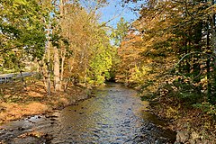
Clinton is a town in Hunterdon County, in the U.S. state of New Jersey. It is located on the South Branch of the Raritan River in the Raritan Valley region. As of the 2020 United States census, the town's population was 2,773, an increase of 54 (+2.0%) from the 2010 census count of 2,719, which in turn reflected an increase of 87 (+3.3%) from the 2,632 counted in the 2000 census. Despite its relatively small population, Clinton is the predominant control city for Interstate 78 traveling westbound from Newark.

<span class="mw-page-title-main">Readington Township, New Jersey</span> Township in Hunterdon County, New Jersey, US

Readington Township is a township located in the easternmost portion of Hunterdon County, in the U.S. state of New Jersey. As of the 2020 United States census, the township's population was 16,128, an increase of two people (+0.0%) from the 2010 census count of 16,126, which in turn reflected an increase of 323 (+2.0%) from the 15,803 counted in the 2000 census.

<span class="mw-page-title-main">Tewksbury Township, New Jersey</span> Township in Hunterdon County, New Jersey, US

Tewksbury Township is a township located in Hunterdon County, in the U.S. state of New Jersey and is located within the New York Metropolitan Area. As of the 2020 United States census, the township's population was 5,870, a decrease of 123 (−2.1%) from the 2010 census count of 5,993, which in turn reflected an increase of 452 (+8.2%) from the 5,541 counted in the 2000 census.

<span class="mw-page-title-main">Whitehouse Station, New Jersey</span> Populated place in Hunterdon County, New Jersey, US

Whitehouse Station, also spelled White House Station, is an unincorporated community and census-designated place (CDP) located within Readington Township, in Hunterdon County, New Jersey. At the 2010 United States Census, the CDP's population was 2,089. Whitehouse Station takes its name from Whitehouse and Abraham Van Horne's 18th century tavern.

<span class="mw-page-title-main">Bedminster, New Jersey</span> Township in Somerset County, New Jersey, US

Bedminster is a township in Somerset County, in the U.S. state of New Jersey. As of the 2020 United States census, the township's population was 8,272, an increase of 107 (+1.3%) from the 2010 census count of 8,165, which in turn reflected a decline of 137 (−1.7%) from the 8,302 counted in the 2000 census. Located within the Raritan Valley region, Bedminster is part of the Somerset Hills of northern Somerset County, bordering both Hunterdon and Morris counties.

<span class="mw-page-title-main">Bernards Township, New Jersey</span> Township in Somerset County, New Jersey, US

Bernards Township is a township in Somerset County, in the U.S. state of New Jersey. As of the 2020 United States census, the township's population was 27,830, an increase of 1,178 (+4.4%) from the 2010 census count of 26,652, reflecting an increase of 2,077 (+8.5%) from the 24,575 counted in the 2000 census.

<span class="mw-page-title-main">Neshanic, New Jersey</span> Populated place in Somerset County, New Jersey, US

Neshanic is an unincorporated community and census-designated place (CDP) located within Hillsborough Township, in Somerset County, in the U.S. state of New Jersey. It is located near the South Branch Raritan River. The Neshanic Historic District was listed on the National Register of Historic Places in 1979.

<span class="mw-page-title-main">Pluckemin, New Jersey</span> Populated place in Somerset County, New Jersey, US

Pluckemin is an unincorporated community and census-designated place (CDP) located within Bedminster Township, in Somerset County, in the U.S. state of New Jersey. It was also known historically as Pluckamin. It was the site of several historic events during the American Revolutionary War.

<span class="mw-page-title-main">National Register of Historic Places listings in New Jersey</span>

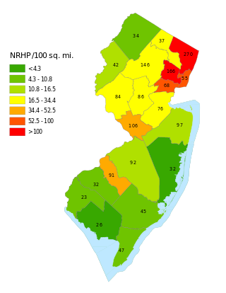
This is a list of properties and districts listed on the National Register of Historic Places in New Jersey. There are more than 1,700 listed sites in New Jersey. Of these, 58 are further designated as National Historic Landmarks. All 21 counties in New Jersey have listings on the National Register.
     This National Park Service list is complete through NPS recent listings posted May 10, 2024.

<span class="mw-page-title-main">Lamington, New Jersey</span> Populated place in Somerset County, New Jersey, US

Lamington is an unincorporated community and census-designated place (CDP) located within Bedminster Township in Somerset County, in the U.S. state of New Jersey. It contains the Lamington Presbyterian Church Cemetery and the Lamington Black Cemetery.

<span class="mw-page-title-main">Somerset Hills</span>

The Somerset Hills is known as the northern region of Somerset County located in the U.S. state of New Jersey and includes the municipalities of Bedminster, Bernardsville, Bernards Township, Far Hills, and Peapack-Gladstone. The southwestern Morris County municipalities of the Chesters and the Mendhams are periodically recognized as part of the Somerset Hills.

<span class="mw-page-title-main">County Route 512 (New Jersey)</span> County highway in New Jersey, U.S.

County Route 512 is a county highway in the U.S. state of New Jersey. The highway extends 32.96 miles (53.04 km) from High Bridge Road in Califon to Springfield Avenue / Route 24 in Summit.

The Purnell School was a progressive private all-girls boarding high school located in Pottersville, within Bedminster, New Jersey, about an hour and one-half west of New York City, and two hours north of Philadelphia. Purnell School was a member of the New Jersey Association of Independent Schools. The school was accredited in 1973 by the Middle States Association of Colleges and Schools Commission on Secondary Schools. The school officially closed following the 2020–21 academic school year citing "“challenges related to the competitive landscape’’.

<span class="mw-page-title-main">Neshanic Station, New Jersey</span> Place in Somerset County, New Jersey, United States

Neshanic Station is an unincorporated community and census-designated place (CDP) located within Branchburg and extending into Hillsborough Township, Somerset County, in the U.S. state of New Jersey. In 2016 most of the village was listed on the National Register of Historic Places as the Neshanic Station Historic District.

<span class="mw-page-title-main">Fairmount, New Jersey</span> Populated place in Hunterdon County, New Jersey, US

Fairmount is an unincorporated community located along County Route 517 in Tewksbury Township of Hunterdon County, New Jersey. The community was first known as Parkersville, named after proprietor James Parker (1725–1797). The southern section of the community is known as Lower Fairmount.

<span class="mw-page-title-main">Whitehouse–Mechanicsville Historic District</span> Historic district in New Jersey, United States

The Whitehouse–Mechanicsville Historic District is a historic district located along old New Jersey Route 28, Mill, Lamington and School Roads in Whitehouse and Mechanicsville, unincorporated communities in Readington Township, Hunterdon County, New Jersey. It was added to the National Register of Historic Places on March 17, 2015 for its significance in architecture and community development. The district includes 140 contributing buildings.

<span class="mw-page-title-main">Taylor's Mill Historic District</span> Historic district in New Jersey, United States

Taylor's Mill Historic District, a 26-acre (11 ha) historic district featuring the gristmill Taylor's Mill, is located along Taylor's Mill Road and Rockaway Road near Oldwick in Readington Township, Hunterdon County, New Jersey. It was added to the National Register of Historic Places on June 11, 1992 for its significance in architecture, exploration/settlement, industry, and military. The district boundary was increased by 8 acres (3.2 ha) in 1997 to cross the Rockaway Creek and extend into Tewksbury Township.

References

  1. "ArcGIS REST Services Directory". United States Census Bureau. Retrieved October 11, 2022.
  2. 1 2 "Pottersville". Geographic Names Information System . United States Geological Survey, United States Department of the Interior.
  3. 1 2 3 Census Data Explorer: Pottersville CDP, New Jersey, United States Census Bureau. Accessed June 15, 2023.
  4. Geographic Codes Lookup for New Jersey, Missouri Census Data Center. Accessed June 9, 2023.
  5. State of New Jersey Census Designated Places - BVP20 - Data as of January 1, 2020, United States Census Bureau. Accessed December 1, 2022.
  6. Locality Search, State of New Jersey. Accessed June 9, 2016.
  7. DP-1 - Profile of General Population and Housing Characteristics: 2010; 2010 Demographic Profile Data for ZCTA 07979 Archived 2020-02-12 at archive.today , United States Census Bureau. Accessed June 9, 2014.
  8. Census of Population and Housing, United States Census Bureau. Accessed June 1, 2023.
  9. Purnell at a Glance [usurped] , Purnell School. Accessed June 9, 2014.
  10. Makin, Cheryl. "Pingry plans to open campus at former Purnell School in Bedminster". Courier News. Retrieved July 26, 2022.
  11. "Pingry completes Purnell purchase in Bedminster for $5M". New Jersey Hills. October 26, 2021. Retrieved July 26, 2022.
  12. "National Register Information System  (#90001475)". National Register of Historic Places . National Park Service. November 2, 2013.
  13. "New Jersey and National Registers of Historic Places – Somerset County" (PDF). New Jersey Department of Environmental Protection – Historic Preservation Office. September 30, 2020. p. 1.
  14. Matherly, Polly A. (January 31, 1988). "National Register of Historic Places Inventory/Nomination: Pottersville Village Historic District". National Park Service. With accompanying 18 photos
  15. Chira, Susan. "HARRIET ADAMS DIES; NANCY DREW AUTHOR WROTE 200 NOVELS", The New York Times , March 29, 1982. Accessed October 7, 2007. "Harriet Stratemeyer Adams, who wrote nearly 200 children's books including many of the Nancy Drew and Hardy Boys series, died Saturday evening. She was 89 years old, and lived in Pottersville and Maplewood, N.J."