
Bethlehem Township is a township in Hunterdon County, in the U.S. state of New Jersey. It is part of the New York metropolitan area. As of the 2020 United States census, the township's population was 3,745, a decrease of 234 (−5.9%) from the 2010 census count of 3,979, which in turn reflected an increase of 159 (+4.2%) from the 3,820 counted in the 2000 census.

Bloomsbury is a borough in Hunterdon County, in the U.S. state of New Jersey. As of the 2020 United States census, the borough's population was 792, a decrease of 78 (−9.0%) from the 2010 census count of 870, which in turn reflected a decline of 16 (−1.8%) from the 886 counted in the 2000 census.

Clinton is a town in Hunterdon County, in the U.S. state of New Jersey. It is located on the South Branch of the Raritan River in the Raritan Valley region. As of the 2020 United States census, the town's population was 2,773, an increase of 54 (+2.0%) from the 2010 census count of 2,719, which in turn reflected an increase of 87 (+3.3%) from the 2,632 counted in the 2000 census. Despite its relatively small population, Clinton is the predominant control city for Interstate 78 traveling westbound from Newark.

Clinton Township is a township in Hunterdon County, in the U.S. state of New Jersey. As of the 2020 United States census, the township's population was 13,505, an increase of 27 (+0.2%) from the 2010 census count of 13,478, which in turn reflected an increase of 521 (+4.0%) from the 12,957 counted in the 2000 census.

East Amwell Township is a township in Hunterdon County, in the U.S. state of New Jersey. As of the 2020 United States census, the township's population was 3,917, a decrease of 96 (−2.4%) from the 2010 census count of 4,013, which in turn reflected a decline of 442 (−9.9%) from the 4,455 counted in the 2000 census.

Flemington is a borough in and the county seat of Hunterdon County, in the U.S. state of New Jersey. Most of the borough is located in the Amwell Valley, a low-lying area of the Newark Basin, and the Raritan Valley, the South Branch of the Raritan River, which flows through the center of Flemington. Northwestern portions of the borough sit on the Hunterdon Plateau. As of the 2020 United States census, the borough's population was 4,876, its highest decennial count ever and an increase of 295 (+6.4%) from the 2010 census count of 4,581, which in turn reflected an increase of 381 (+9.1%) from the 4,200 counted in the 2000 census.

Franklin Township is a township in central Hunterdon County, in the U.S. state of New Jersey. As of the 2020 United States census, the township's population was 3,267, an increase of 72 (+2.3%) from the 2010 census count of 3,195, which in turn reflected an increase of 205 (+6.9%) from the 2,990 counted in the 2000 census. Most of the township lies on the Hunterdon Plateau with only the eastern section along the South Branch Raritan River being on the lower part of the Newark Basin.

Glen Gardner is a borough in Hunterdon County, in the U.S. state of New Jersey. As of the 2020 United States census, the borough's population was 1,682, a decrease of 22 (−1.3%) from the 2010 census count of 1,704, which in turn reflected a decline of 198 (−10.4%) from the 1,902 counted in the 2000 census.

Hampton is a borough in Hunterdon County, in the U.S. state of New Jersey. As of the 2020 United States census, the borough's population was 1,438, an increase of 37 (+2.6%) from the 2010 census count of 1,401, which in turn reflected a decline of 145 (−9.4%) from the 1,546 counted in the 2000 census.
Lambertville is a city within Hunterdon County in the U.S. state of New Jersey. As of the 2020 United States census, the city's population was 4,139, an increase of 233 (+6.0%) from the 3,906 recorded at the 2010 census, which in turn reflected an increase of 38 (1.0%) from the 3,868 counted in the 2000 census.

Lebanon is a borough in Hunterdon County, in the U.S. state of New Jersey. As of the 2020 United States census, the borough's population was 1,665, the highest ever in any decennial census and an increase of 307 (+22.6%) from the 2010 census count of 1,358, which in turn reflected an increase of 293 (+27.5%) from the 1,065 counted in the 2000 census.
Lebanon Township is the northernmost township in Hunterdon County, in the U.S. state of New Jersey. As of the 2020 United States census, the township's population was 6,195, a decrease of 393 (−6.0%) from the 2010 census count of 6,588, which in turn reflected an increase of 772 (+13.3%) from the 5,816 counted in the 2000 census.

Raritan Township is a township in Hunterdon County, in the U.S. state of New Jersey. As of the 2020 United States census, the township's population was 23,447, an increase of 1,262 (+5.7%) from the 2010 census count of 22,185, which in turn reflected an increase of 2,376 (+12.0%) from the 19,809 counted in the 2000 census. The township is located within the heart of the Amwell Valley and Raritan Valley regions, as the South Branch of the Raritan River flows through the center of the township. The northwestern portion of the township is located on the Hunterdon Plateau.

Readington Township is a township located in the easternmost portion of Hunterdon County, in the U.S. state of New Jersey. As of the 2020 United States census, the township's population was 16,128, an increase of two people (+0.0%) from the 2010 census count of 16,126, which in turn reflected an increase of 323 (+2.0%) from the 15,803 counted in the 2000 census.

Stockton is a borough in Hunterdon County, in the U.S. state of New Jersey. The borough sits on the Delaware River at the western end of Amwell Valley. As of the 2020 United States census, the borough's population was 495, a decrease of 43 (−8.0%) from the 2010 census count of 538, which in turn reflected a decline of 22 (−3.9%) from the 560 counted in the 2000 census.

West Amwell Township is a township in Hunterdon County, in the U.S. state of New Jersey. As of the 2020 United States census, the township's population was 3,005, a decrease of 835 (−21.7%) from the 2010 census count of 3,840, which in turn reflected an increase of 1,457 (+61.1%) from the 2,383 counted in the 2000 census.

Whitehouse Station, also spelled White House Station, is an unincorporated community and census-designated place (CDP) located within Readington Township, in Hunterdon County, New Jersey. At the 2010 United States Census, the CDP's population was 2,089. Whitehouse Station takes its name from Whitehouse and Abraham Van Horne's 18th century tavern.
New Jersey's 7th congressional district includes all of Hunterdon and Warren Counties; and parts of Morris, Somerset, Sussex, and Union Counties. The district is represented by Republican Thomas Kean Jr., who was first elected in 2022, defeating Democratic incumbent Tom Malinowski.
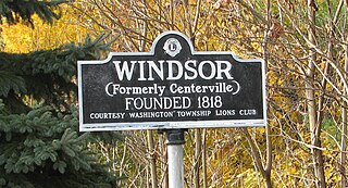
Windsor is a small historic unincorporated community and census-designated place (CDP) located within Robbinsville Township in Mercer County, in the U.S. state of New Jersey. The area is served as United States Postal Service ZIP Code 08561. As of the 2020 United States census, the CDP's population was 330, an increase of 104 (+46.0%) above the 226 counted at the 2010 census. The community, covering 570 acres (230 ha), was added to the National Register of Historic Places in 1992.

Horace Griggs Prall was a New Jersey attorney and Republican politician. He served for a number of years as a state legislator and a short term as acting governor of New Jersey in 1935.


