
Hunterdon County is a county located in the western section of the U.S. state of New Jersey. At the 2020 census, the county was the state's 18th-most populous county, with a population of 128,947, its highest decennial count ever and an increase of 598 (+0.5%) from the 2010 census count of 128,349, which in turn reflected an increase of 6,360 (5.2%) from the 121,989 counted in the 2000 census. Its county seat is Flemington.

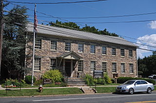
Bethlehem Township is a township in Hunterdon County, in the U.S. state of New Jersey. It is part of the New York metropolitan area. As of the 2020 United States census, the township's population was 3,745, a decrease of 234 (−5.9%) from the 2010 census count of 3,979, which in turn reflected an increase of 159 (+4.2%) from the 3,820 counted in the 2000 census.

Clinton Township is a township in Hunterdon County, in the U.S. state of New Jersey. As of the 2020 United States census, the township's population was 13,505, an increase of 27 (+0.2%) from the 2010 census count of 13,478, which in turn reflected an increase of 521 (+4.0%) from the 12,957 counted in the 2000 census.
Delaware Township is a township in Hunterdon County, in the U.S. state of New Jersey. Part of the township is on the Hunterdon Plateau, while the southern portions are in the Amwell Valley. As of the 2020 United States census, the township's population was 4,560, a decrease of three people (−0.1%) from the 2010 census count of 4,563, which in turn reflected an increase of 85 (+1.9%) from the 4,478 counted in the 2000 census.

East Amwell Township is a township in Hunterdon County, in the U.S. state of New Jersey. As of the 2020 United States census, the township's population was 3,917, a decrease of 96 (−2.4%) from the 2010 census count of 4,013, which in turn reflected a decline of 442 (−9.9%) from the 4,455 counted in the 2000 census.

Flemington is a borough in and the county seat of Hunterdon County, in the U.S. state of New Jersey. Most of the borough is located in the Amwell Valley, a low-lying area of the Newark Basin, and the Raritan Valley, the South Branch of the Raritan River, which flows through the center of Flemington. Northwestern portions of the borough sit on the Hunterdon Plateau. As of the 2020 United States census, the borough's population was 4,876, its highest decennial count ever and an increase of 295 (+6.4%) from the 2010 census count of 4,581, which in turn reflected an increase of 381 (+9.1%) from the 4,200 counted in the 2000 census.

Holland Township is a township in Hunterdon County, in the U.S. state of New Jersey. As of the 2020 United States census, the township's population was 5,177, a decrease of 114 (−2.2%) from the 2010 census count of 5,291, which in turn reflected an increase of 167 (+3.3%) from the 5,124 counted in the 2000 census.

Kingwood Township is a township in Hunterdon County, in the U.S. state of New Jersey, located on the Hunterdon Plateau. As of the 2020 United States census, the township's population was 3,802, a decrease of 43 (−1.1%) from the 2010 census count of 3,845, which in turn reflected an increase of 63 (+1.7%) from the 3,782 counted in the 2000 census.
Lebanon Township is the northernmost township in Hunterdon County, in the U.S. state of New Jersey. As of the 2020 United States census, the township's population was 6,195, a decrease of 393 (−6.0%) from the 2010 census count of 6,588, which in turn reflected an increase of 772 (+13.3%) from the 5,816 counted in the 2000 census.

Raritan Township is a township in Hunterdon County, in the U.S. state of New Jersey. As of the 2020 United States census, the township's population was 23,447, an increase of 1,262 (+5.7%) from the 2010 census count of 22,185, which in turn reflected an increase of 2,376 (+12.0%) from the 19,809 counted in the 2000 census. The township is located within the heart of the Amwell Valley and Raritan Valley regions, as the South Branch of the Raritan River flows through the center of the township. The northwestern portion of the township is located on the Hunterdon Plateau.

Readington Township is a township located in the easternmost portion of Hunterdon County, in the U.S. state of New Jersey. As of the 2020 United States census, the township's population was 16,128, an increase of two people (+0.0%) from the 2010 census count of 16,126, which in turn reflected an increase of 323 (+2.0%) from the 15,803 counted in the 2000 census.

Central Jersey is the central region of the U.S. state of New Jersey. The designation of Central New Jersey is a distinct administrative toponym. While the State of New Jersey is often divided into North Jersey and South Jersey, many residents, including the governor, Phil Murphy, recognize Central Jersey as a distinct entity.

Norton is an unincorporated community located within Union Township, in Hunterdon County, New Jersey. Norton is located on County Route 635, approximately 1.5 mi (2.4 km) northwest of Interstate 78. The village is included in the Van Syckel Corner District, which was added to the National Register of Historic Places in 1979.

Baptistown is an unincorporated community located within Kingwood Township, in Hunterdon County, New Jersey, United States. Baptistown is located on New Jersey Route 12, approximately three miles (4.8 km) east of Frenchtown. The township's municipal offices are located in Baptistown just north of the center of the community.
Cherryville is an unincorporated community located within Franklin Township, in Hunterdon County, New Jersey, United States.
Amsterdam is an unincorporated community located within Holland Township in Hunterdon County, in the U.S. state of New Jersey. Located on the southern flank of the Musconetcong Mountain, the area was settled in the first half of the 18th century. It was later named after Amsterdam, Netherlands. The Amsterdam Historic District, encompassing the community, was listed on the state and national registers of historic places in 1995.

Barbertown is an unincorporated community located within Kingwood Township in Hunterdon County, New Jersey, United States.

Hoffmans, also known as Hoffman's Crossing, is an unincorporated community located along Hoffman's Crossing Road and the South Branch Raritan River within Lebanon Township in Hunterdon County, New Jersey. It is about 1.5 miles (2.4 km) from Califon. The main road in the community is County Route 513. The Hunterdon County Educational Services Commission (HCESC) has a campus here.
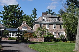
Lansdowne is an unincorporated community located within Franklin Township in Hunterdon County, New Jersey. It was named after Lansdown, England. Judge Samuel Johnston (1706–1785) owned a large estate here. Charles Stewart (1729–1800) married Mary Oakley Johnston, daughter of the judge, and lived in the mansion built here, Lansdown, which is listed on the National Register of Historic Places.

Mount Airy is an unincorporated community located within West Amwell Township in Hunterdon County, New Jersey, United States.


