Voorhees (CDP), New Jersey

Last updated

Voorhees, New Jersey
Location map of Somerset County, New Jersey.svg
Red pog.svg
Voorhees CDP
Location in Somerset County
USA New Jersey relief location map.svg
Red pog.svg
Voorhees CDP
Location in New Jersey
Usa edcp relief location map.png
Red pog.svg
Voorhees CDP
Location in the United States
Coordinates: 40°28′56″N74°29′33″W / 40.482176°N 74.492506°W / 40.482176; -74.492506 [1] [2]
Country Flag of the United States.svg  United States
State Flag of New Jersey.svg  New Jersey
County Somerset
Township Franklin
Area
[3]
  Total0.72 sq mi (1.86 km2)
  Land0.72 sq mi (1.86 km2)
  Water0.00 sq mi (0.00 km2)  0.00%
Elevation
[4]
125 ft (38 m)
Population
 (2020) [5]
  Total1,517
  Density2,112.81/sq mi (815.73/km2)
Time zone UTC−05:00 (Eastern (EST))
  Summer (DST) UTC−04:00 (Eastern (EDT))
Area code(s) 609/640 and 732/848
FIPS code 34-76250 [1] [2] [6]
GNIS feature ID02584039 [1] [2]

Voorhees is an unincorporated community and census-designated place (CDP) located in Franklin Township, in Somerset County, in the U.S. state of New Jersey. [7] [8] [9] [10] As of the 2010 United States Census, the CDP's population was 1,959. [11]

Contents

Geography

According to the United States Census Bureau, Voorhees had a total area of 0.718 square miles (1.860 km2), all of which was land. [1] [2]

Demographics

Historical population
CensusPop.Note
2010 976
2020 1,51755.4%
Population sources: 2010 [11] [5]

2010 census

The 2010 United States census counted 976 people, 301 households, and 248 families in the CDP. The population density was 1,359.2 per square mile (524.8/km2). There were 317 housing units at an average density of 441.5 per square mile (170.5/km2). The racial makeup was 16.80% (164) White, 62.91% (614) Black or African American, 1.43% (14) Native American, 5.94% (58) Asian, 0.00% (0) Pacific Islander, 8.71% (85) from other races, and 4.20% (41) from two or more races. Hispanic or Latino of any race were 23.98% (234) of the population. [11]

Of the 301 households, 43.9% had children under the age of 18; 41.5% were married couples living together; 32.2% had a female householder with no husband present and 17.6% were non-families. Of all households, 13.3% were made up of individuals and 4.3% had someone living alone who was 65 years of age or older. The average household size was 3.24 and the average family size was 3.53. [11]

32.8% of the population were under the age of 18, 8.7% from 18 to 24, 28.1% from 25 to 44, 21.9% from 45 to 64, and 8.5% who were 65 years of age or older. The median age was 31.3 years. For every 100 females, the population had 80.1 males. For every 100 females ages 18 and older there were 75.4 males. [11]

Related Research Articles

<span class="mw-page-title-main">Echelon, New Jersey</span> Populated place in Camden County, New Jersey, US

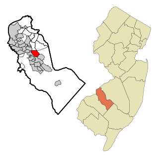
Echelon is an unincorporated community and census-designated place (CDP) located within Voorhees Township in Camden County, in the U.S. state of New Jersey. As of the 2010 United States Census, the CDP's population was 10,743.

<span class="mw-page-title-main">Plainsboro Center, New Jersey</span> Populated place in Middlesex County, New Jersey, US

Plainsboro Center is an unincorporated community and census-designated place (CDP) located within Plainsboro Township, situated in southern Middlesex County, within the U.S. state of New Jersey. As of the 2020 United States census, the CDP's population was 2,760, its highest decennial count ever and an increase of 48 (+1.8%) from the 2,712 recorded at the 2010 census, which in turn reflected an increase of 503 (+22.8%) from the 2,209 counted in the 2000 census.

<span class="mw-page-title-main">Cedar Glen Lakes, New Jersey</span> Populated place in Ocean County, New Jersey, US

Cedar Glen Lakes is an unincorporated community and census-designated place (CDP) located within Manchester Township, in Ocean County, in the U.S. state of New Jersey. As of the 2010 United States Census, the CDP's population was 1,421.

<span class="mw-page-title-main">Crestwood Village, New Jersey</span> CDP in Ocean County, New Jersey, US

Crestwood Village is an unincorporated community and census-designated place (CDP) located within Manchester Township, in Ocean County, in the U.S. state of New Jersey. As of the 2010 United States Census, the CDP's population was 7,907.

<span class="mw-page-title-main">Leisure Knoll, New Jersey</span> Populated place in Ocean County, New Jersey, US

Leisure Knoll is an unincorporated community and census-designated place (CDP) located within Manchester Township, in Ocean County, in the U.S. state of New Jersey. As of the 2010 United States Census, the CDP's population was 2,490.

<span class="mw-page-title-main">Vista Center, New Jersey</span> Populated place in Ocean County, New Jersey, US

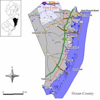
Vista Center is an unincorporated community and census-designated place (CDP) located within Jackson Township in Ocean County, in the U.S. state of New Jersey. As of the 2010 United States Census, the CDP's population was 3,689.

<span class="mw-page-title-main">Blackwells Mills, New Jersey</span> Populated place in Somerset County, New Jersey, US

Blackwells Mills is an unincorporated community and census-designated place (CDP) located in Franklin Township in Somerset County, in the U.S. state of New Jersey. As of the 2010 U.S. census, the CDP's population was 803.

<span class="mw-page-title-main">Harlingen, New Jersey</span> Populated place in Somerset County, New Jersey, US

Harlingen is an unincorporated community and census-designated place (CDP) located within Montgomery Township, in Somerset County, in the U.S. state of New Jersey. As of the 2010 United States Census, the CDP's population was 297.

<span class="mw-page-title-main">Middlebush, New Jersey</span> Populated place in Somerset County, New Jersey, US

Middlebush is an unincorporated community and census-designated place (CDP) located in Franklin Township, in Somerset County, in the U.S. state of New Jersey. As of the 2010 United States Census, the CDP's population was 2,326. It is perhaps most distinguished as being the host section for Franklin Township's municipal complex.

<span class="mw-page-title-main">East Millstone, New Jersey</span> Populated place in Somerset County, New Jersey, US

East Millstone is an unincorporated community and census-designated place (CDP) located in Franklin Township in Somerset County, in the U.S. state of New Jersey.

<span class="mw-page-title-main">Pleasant Plains, New Jersey</span> Populated place in Somerset County, New Jersey, US

Pleasant Plains is an unincorporated community and census-designated place (CDP) located in Franklin Township, in Somerset County, in the U.S. state of New Jersey. As of the 2010 United States Census, the CDP's population was 922. Having no distinct boundaries, a large area in the center of Franklin Township centered on the intersections of South Middlebush Road with Claremont and Suydam Roads is generally considered Pleasant Plains.

<span class="mw-page-title-main">Elwood, New Jersey</span> Populated place in Atlantic County, New Jersey, US

Elwood is an unincorporated community and census-designated place (CDP) located within Mullica Township in Atlantic County, in the U.S. state of New Jersey. As of the 2010 United States Census, the CDP's population was 1,437. At previous censuses, the area was listed by the U.S. Census Bureau as the Elwood-Magnolia CDP. The area is served as United States Postal Service ZIP Code 08217.

Clyde is an unincorporated community and census-designated place (CDP) located in Franklin Township, in Somerset County, in the U.S. state of New Jersey. It was a station stop on the Penna RR's Millstone Branch. As of the 2010 United States Census, the CDP's population was 213.

East Franklin is an unincorporated community and census-designated place (CDP) located in Franklin Township, in Somerset County, in the U.S. state of New Jersey. At the 2010 United States Census, East Franklin's population was 8,669.

East Rocky Hill is an unincorporated community and census-designated place (CDP) located in Franklin Township, in Somerset County, in the U.S. state of New Jersey. As of the 2010 United States Census, the CDP's population was 469.

Franklin Center is an unincorporated community and census-designated place (CDP) located in Franklin Township, in Somerset County, in the U.S. state of New Jersey. As of the 2010 United States Census, the CDP's population was 4,460.

<span class="mw-page-title-main">Finderne, New Jersey</span> Populated place in Somerset County, New Jersey, US

Finderne is an unincorporated community and census-designated place (CDP) located within Bridgewater Township, in Somerset County, in the U.S. state of New Jersey. As of the 2010 United States Census, the CDP's population was 5,600.

<span class="mw-page-title-main">Bradley Gardens, New Jersey</span> Populated place in Somerset County, New Jersey, US

Bradley Gardens is an unincorporated community and census-designated place (CDP) located within Bridgewater Township, in Somerset County, in the U.S. state of New Jersey. As of the 2010 United States Census, the CDP's population was 14,206.

Green Knoll is an unincorporated community and census-designated place (CDP) located within Bridgewater Township, in Somerset County, in the U.S. state of New Jersey. As of the 2010 United States Census, the CDP's population was 6,200.

<span class="mw-page-title-main">Ten Mile Run, New Jersey</span> Populated place in Somerset County, New Jersey, US

Ten Mile Run is an unincorporated community and census-designated place (CDP) located in Franklin Township, in Somerset County, in the U.S. state of New Jersey. As of the 2010 United States Census, the CDP's population was 1,959.

References

  1. 1 2 3 4 Gazetteer of New Jersey Places, United States Census Bureau. Accessed July 21, 2016.
  2. 1 2 3 4 US Gazetteer files: 2010, 2000, and 1990, United States Census Bureau. Accessed September 4, 2014.
  3. "ArcGIS REST Services Directory". United States Census Bureau. Retrieved October 11, 2022.
  4. U.S. Geological Survey Geographic Names Information System: Voorhees Census Designated Place, Geographic Names Information System. Accessed August 23, 2012.
  5. 1 2 "Census Population API". United States Census Bureau. Retrieved October 11, 2022.
  6. Geographic Codes Lookup for New Jersey, Missouri Census Data Center. Accessed June 9, 2023.
  7. GCT-PH1 - Population, Housing Units, Area, and Density: 2010 - County -- County Subdivision and Place from the 2010 Census Summary File 1 for Somerset County, New Jersey Archived 2020-02-12 at archive.today , United States Census Bureau. Accessed February 11, 2013.
  8. 2006-2010 American Community Survey Geography for New Jersey, United States Census Bureau. Accessed February 11, 2013.
  9. New Jersey: 2010 - Population and Housing Unit Counts - 2010 Census of Population and Housing (CPH-2-32), United States Census Bureau, August 2012. Accessed February 11, 2013.
  10. Locality Search, State of New Jersey. Accessed April 19, 2015.
  11. 1 2 3 4 5 DP-1 - Profile of General Population and Housing Characteristics: 2010 Demographic Profile Data for Voorhees CDP, New Jersey, United States Census Bureau. Accessed February 11, 2013.