The name Raritan possibly derives from a branch of the Lenape people called the Nariticongs, the first people known to settle the Raritan Valley.[4][5]
Following conflict with the arriving Dutch colonists, the native people of the region, especially the Sanhican, were forced to sell their territory near the Raritan Bay and move further inland along the river valley.[6] As English colonists took over the region, they took advantage of the river's location between New York and Philadelphia as well as a road network developed by the Lenape to turn the region into a transportation and commercial hub.[7] As a result, the Raritan River became an important waterway for colonial travel and trade,[8] allowing for the development of trade centers like Raritan Landing and New Brunswick, where agricultural and raw material goods could be sold.[7]
The success of the Erie Canal (completed in 1825) sparked a "canal fever" in the United States, catalyzing the construction of the Delaware and Raritan Canal (D&R) between New Brunswick on the Raritan and Bordentown on the Delaware River. The D&R was completed in 1834 and provided a critical link between Philadelphia (and the rest of the greater Mid-Atlantic region, at large) and New York (and the rest of the greater New England region, at large), as these cities were situated along the crucial rivers of the Delaware and the Hudson, respectively.[10] The vast majority of traffic along the canal was Pennsylvaniaanthracite coal with the rest consisting mostly of agricultural and textile goods. At its peak in 1866 the D&R transported more cargo than the Erie Canal.[11] In 1932 the D&R canal shut down for commercial use. In 1974 the canal was developed as a state park for recreational use and remains in use as a water supply for central New Jersey.[12] Various mill towns were formed along the canal and the aforementioned river (and tributaries), most notably (from south to north / west to east) being Trenton, Kingston, Blackwells Mills, Griggstown, Hillsborough, Manville, Chester, Bernards, Clinton, Raritan, Milltown, and Woodbridge.[13][14][15]
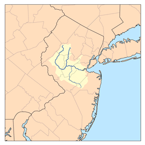
After the confluence of the North and South branches, the Raritan River flows for approximately 16mi (26km), before slowing in tidewater at New Brunswick. Its estuary extends 14mi (23km) more, entering the western end of Raritan Bay at South Amboy.[17]
The river is also used for recreational boating, including use by the rowing team of Rutgers University in New Brunswick. The river is featured in the title of Rutgers' alma mater, On the Banks of the Old Raritan, and its flooding is mentioned in the song.[19]
The Raritan River is an important source of drinking water for the central portion of New Jersey. A water filtration plant operated by New Jersey American Water is located in Somerset and draws its water at the confluence of the Raritan River and its largest tributary (the Millstone River), providing an average of 132,000,000 US gallons (500,000m3) of water per day.[23]
The New Jersey Water Supply Authority operates two reservoirs off of the Raritan river, the Spruce Run Reservoir and Round Valley Reservoir, and controls releases of water to ensure the “minimum passing flow rates” enforced by the New Jersey Department of Environmental Protection.[24] Additionally, the Delaware and Raritan Canal, managed by the New Jersey Water Supply Authority, serves as a water supply that pumps over 100,000,000 US gallons (380,000m3) of water per day from the Delaware to the Raritan river and serves over 1 million customers along the way[25]
Flooding
The Raritan River has persistent flooding problems when excessive rain from storms affects the river basin. The flooding problems mainly affect the town of Bound Brook, which is partially built on a natural floodplain at the junction of several tributaries, and Manville, which has a large neighborhood known as Lost Valley that lies on the floodplain between the Raritan River and its largest tributary river, which is known as the Millstone River. Other towns in the Raritan River basin also experience flooding to a lesser degree.[citation needed]
Record flooding in the aftermath of Hurricane Floyd in September 1999 (42.13ft (12.84m)) flood crest, 14ft (4.3m) above flood stage) caused renewed interest in a flood control project called the Green Brook Flood Control Project, which is designed to protect Bound Brook from a 150-year flood. In August 2011, record flooding occurred once again after Hurricane Irene swept through the area. This problem was exacerbated by well-above average rainfall that fell in the weeks before the storm hit, and spurred completion of the Army Corps of Engineers flood control project.[26] As of 2015, the current status of this project is:
The R2 levee system is functionally complete – The R2 Levee System is designed to provide Bound Brook with protection from a 150-year flood level. The levee is built to the height of the raised Talmage Avenue Bridge.
Closure gates along Raritan are functionally complete – The gate closures across the New Jersey Transit railroad tracks on the western side of Bound Brook and at the South Main Street railroad underpass that leads to Queens Bridge have been completed and are used to keep flood waters out of Bound Brook.
The new Talmadge Avenue Bridge that connects Bound Brook and Bridgewater, New Jersey is functionally complete. The replacement bridge was built to the height of the R2 Levee to prevent Middle Brook and Raritan River waters from entering Bound Brook from the west.
To improve water flow through Bound Brook, the former Conrail bridge over the Raritan River and its associated railroad embankment that were located east of Bound Brook were removed during 2007. The bridge and embankment, when they were in place, acted to block the river flow through the Bound Brook area. To build the main Bound Brook R2 levee, the bridge and embankment needed to be removed.[27]
Gallery
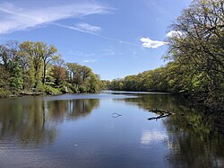
Confluence of the South Branch and the North Branch with the Raritan River in Branchburg
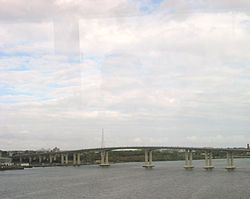
The Driscoll Bridge, with a total of 15 travel lanes and 6 shoulder lanes, is one of the world's widest and busiest motor vehicle bridges, as it crosses the Raritan River, connecting Sayreville and Woodbridge
↑ Waldman, John R. (1999). Heartbeats in the muck: the history, sea life, and environment of New York Harbor. New York: Lyons Press. ISBN1-55821-720-7. OCLC41674270.
1 2 DeAngelo, W. A. (2008). "The History of Middlesex County"(PDF). New Brunswick: Middlesex County Board of Chosen Freeholders. pp.22–23. Archived from the original(PDF) on September 29, 2020. Retrieved January 31, 2021.
This page is based on this Wikipedia article Text is available under the CC BY-SA 4.0 license; additional terms may apply. Images, videos and audio are available under their respective licenses.