Related Research Articles

Sayreville is a borough in Middlesex County, in the U.S. state of New Jersey. Sayreville is within the heart of the Raritan Valley region, located on the south banks of the Raritan River, and also located on the Raritan Bay. As of the 2020 United States census, the borough's population was 45,345, an increase of 2,641 (+6.2%) from the 2010 census count of 42,704, which in turn reflected an increase of 2,327 (+5.8%) from the 40,377 counted in the 2000 census.
In urban planning, brownfield land is any previously developed land that is not currently in use. It may be affected by contamination, but this is not required for a site to be considered brownfield. The term is also used to describe land previously used for industrial or commercial purposes with known or suspected pollution including soil contamination due to hazardous waste.

Industrial waste is the waste produced by industrial activity which includes any material that is rendered useless during a manufacturing process such as that of factories, mills, and mining operations. Types of industrial waste include dirt and gravel, masonry and concrete, scrap metal, oil, solvents, chemicals, scrap lumber, even vegetable matter from restaurants. Industrial waste may be solid, semi-solid or liquid in form. It may be hazardous waste or non-hazardous waste. Industrial waste may pollute the nearby soil or adjacent water bodies, and can contaminate groundwater, lakes, streams, rivers or coastal waters. Industrial waste is often mixed into municipal waste, making accurate assessments difficult. An estimate for the US goes as high as 7.6 billion tons of industrial waste produced annually, as of 2017. Most countries have enacted legislation to deal with the problem of industrial waste, but strictness and compliance regimes vary. Enforcement is always an issue.

Raritan River is a major river of New Jersey. Its watershed drains much of the mountainous area of the central part of the state, emptying into the Raritan Bay on the Atlantic Ocean.

The Delaware and Raritan Canal is a canal in central New Jersey, built in the 1830s, that served to connect the Delaware River to the Raritan River. It was an efficient and reliable means of transportation of freight between Philadelphia and New York City, especially coal from the anthracite fields in eastern Pennsylvania, during much of the 19th and early 20th centuries. The canal allowed shippers to cut many miles off the existing route from the Pennsylvania coal fields, down the Delaware, around Cape May, and up along the Atlantic Ocean coast to New York City.

Passaic River is a river, approximately 80 miles (130 km) long, in Northern New Jersey. The river in its upper course flows in a highly circuitous route, meandering through the swamp lowlands between the ridge hills of rural and suburban northern New Jersey, called the Great Swamp, draining much of the northern portion of the state through its tributaries. In its lower (southern) portion, it flows through the most urbanized and industrialized areas of the state, including along Downtown Newark. The lower river suffered from severe pollution and industrial abandonment in the 20th century. In April 2014, the U.S. Environmental Protection Agency (EPA) announced a $1.7 billion plan to remove 4.3 million cubic yards of toxic mud from the bottom of lower eight miles (13 km) of the river. It is considered one of the most polluted stretches of water in the nation and the project one of the largest clean-ups ever undertaken.
The Rahway River is a river in Essex, Middlesex, and Union Counties, New Jersey, United States, The Rahway, along with the Elizabeth River, Piles Creek, Passaic River, Morses Creek, the Fresh Kills River, has its river mouth at the Arthur Kill.

Central Jersey is the central region of the U.S. state of New Jersey. The designation of Central New Jersey is a distinct administrative toponym.

The Raritan Bayshore is a region in central sections in the state of New Jersey. It is the area around Raritan Bay from The Amboys to Sandy Hook, in Monmouth and Middlesex counties, including the towns of Woodbridge, Perth Amboy, South Amboy, Sayreville, Old Bridge, Matawan, Aberdeen, Keyport, Union Beach, Hazlet, Keansburg, Middletown, Atlantic Highlands, and Highlands. It is the northernmost part of the Jersey Shore, located just south of New York City. At Keansburg is a traditional amusement park while at Sandy Hook are found ocean beaches. The Sadowski Parkway beach area in Perth Amboy, which lies at the mouth of the Raritan River, was deemed the "Riviera of New Jersey" by local government. In recent years many of the beaches on the Bayshore area have been rediscovered and upgraded.
Pure Earth is a New York City-based international not-for-profit organization founded in 1999 that works to identify, clean up, and solve pollution problems in low- and middle-income countries, where high concentrations of toxic pollution have devastating health impacts, especially on children. These communities suffer disproportionately from pollution-related diseases. Pure Earth remains the only significant organization of its kind working to solve pollution on a global scale.
The California Department of Toxic Substances Control is an agency of the government of the state of California. The mission of the DTSC is to protect public health and the environment from toxic harm. DTSC is part of the California Environmental Protection Agency (Cal/EPA), has more than one thousand employees, and is headquartered in Sacramento. DTSC also has a number of regional offices across the state including two environmental chemistry laboratories, and field offices in Sacramento, Berkeley, Los Angeles, Chatsworth, Commerce, Cypress, Clovis (Fresno), San Diego and Calexico.

The Kin-Buc Landfill is a 220-acre (0.89 km2) Superfund site located in Edison, New Jersey where 70 million US gallons (260,000 m3) of liquid toxic waste and 1 million tons of solid waste were dumped. It was active from the late 1940s to 1976. It was ordered closed in 1977. Cleanup operations have been underway to address environmental issues with contamination from 1980s through to 2000s. This site was one of the largest superfund sites in New Jersey having taken in around 90 million US gallons (340,000 m3). The site is heavily contaminated with PCBs, which leaked into Edmonds Creek, a tributary of the Raritan River.
The Edison Wetlands Association was founded by noted activist Robert Spiegel in 1989 as a nonprofit environmental organization devoted to the cleanup of hazardous waste sites and the preservation of open space in densely populated central New Jersey.

The Old Stone Arch Bridge is a bridge located in Bound Brook, New Jersey, United States. It is the second-oldest extant bridge in the US, after the Frankford Avenue Bridge over Pennypack Creek in North Philadelphia, Pennsylvania. Built in 1731, it is the oldest bridge in New Jersey. It spans the Green Brook and connects Bound Brook with Middlesex Borough in northern central New Jersey.

Between 1947 and 1977, General Electric polluted the Hudson River by discharging polychlorinated biphenyls (PCBs) causing a range of harmful effects to wildlife and people who eat fish from the river. Other kinds of pollution, including mercury contamination and cities discharging untreated sewage, have also caused problems in the river.
The Rockaway Borough Well Field is a Superfund site that came into place in 1981 after the soil was suspected of being contaminated with toxic chemicals. The site is located in Rockaway, Morris County, New Jersey. It was first found to be an official Superfund site after it was discovered that tetrachloroethene (PCE) and trichloroethylene (TCE) were contaminating the soil. Studies suspected that the chemicals were coming from the area of two companies in the town of Rockaway. In 1985, the residents of Rockaway were advised not to drink the tap water and the National Guard had to come and supply water supplies for the community. The town soon installed a water filter system in order to try to reduce the amount of pollution in the water. After finding that the system was not effective, the NJDEP came to the scene to investigate the soil. NJDEP found that the soil tested positive with chemicals and from there the EPA were contacted. The EPA found chemicals in different areas of the borough and found that the soil was contaminated and began to install a groundwater treatment system that functioned to purify the ground of chemicals. The system was soon pumping up to 900,000 gallons of water from the boroughs wells. Today, the pump is still functioning and has since reduced the amount of chemicals and the chance of pollution in the water to appear again. The final project to completely purify the water is still in production.
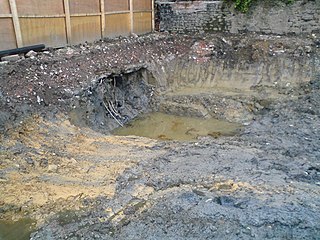
The Horseshoe Road Complex Superfund Site in Sayreville, New Jersey is a 12-acre property located near the Raritan River. The industrial site has been out of operation since the early 1980s after a fire revealed 70 drums containing silver cyanide, ethyl acetate, and acetonitrile. The drums caught the attention of the Environmental Protection Agency (EPA) and by 1995 the Horseshoe Road Complex was on the National Priorities List. The site had three areas consisting of the Atlantic Development Corporation (ADC), Horseshoe Road Drum Dump, and Sayreville Pesticide Dump. The neighboring Atlantic Resources Corporation, the location for precious metal recovery, is addressed with the Horseshoe Road Complex (HRC) site due to the intermixing of chemical contamination. The on-site contamination is not an immediate threat to the surrounding community, although prolonged or repeated exposure to the site itself, will result in health effects. The HRC Superfund site is now in its final steps of cleanup in accordance to the EPA's plan.
Brook Industrial Park (BIP) is an industrial area occupying 4.5 acres of the Borough of Bound Brook, New Jersey, in the United States of America. It is located on the northern bank of the Raritan River. Industrial, chemical and pesticide operations began in 1971 and eventually lead to the contamination of groundwater and exposure of workers to harmful dioxins. Throughout 1980 to 1988 the United States Environmental Protection Agency (EPA) and the New Jersey Department of Environmental Protection (NJDEP) conducted studies to determine if there were any threats being posed on the workers, community or environment by the BIP companies in their disposal of processed and stored chemicals.

Environmental law in New Jersey consists of legislative and regulatory efforts to protect the natural environment in the State of New Jersey. Such efforts include laws and regulations to reduce air and water pollution, regulate the purity of drinking water, remediate contaminated sites, and preserve lands from development, particularly in the Pinelands of southern New Jersey and the Highlands in the north of the state. Environmental laws in New Jersey are enforced primarily by the New Jersey Department of Environmental Protection (NJDEP).
The Garfield Groundwater Contamination site is a Superfund site located in Garfield, New Jersey. The site was formally occupied by E.C Electroplating, an electroplating company that used chromic acid solution in their products. In 1983, a tank at the E.C Electroplating property malfunctioned and spilled chromic acid into the groundwater underneath the property that subsequently spread to the surrounding area. The contamination presented a health risk to Garfield residents in the area due to exposure to hexavalent chromium, a toxic form of chromium. The site was designated a Superfund site in 2011. Cleanup of the site is ongoing as of 2022.
References
- ↑ Munoz, Daniel (2014-09-29). "Rutgers Administration Holds Public Meeting on Strategic Plan - New Brunswick Today | New Brunswick, NJ Local News". New Brunswick Today | New Brunswick, NJ Local News. Retrieved 2023-02-13.