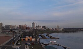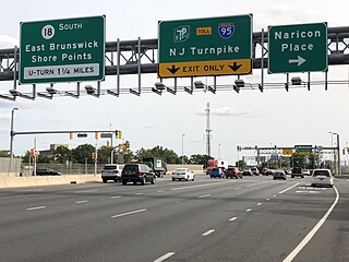
East Brunswick is a township in Middlesex County, in the U.S. state of New Jersey. The suburban bedroom community is part of the New York City metropolitan area and is located on the southern shore of the Raritan River, directly adjacent to the city of New Brunswick and located roughly 29 miles (47 km) away from New York City. As of the 2020 United States census, the township's population was 49,715, its highest decennial count ever and an increase of 2,203 (+4.6%) from the 2010 census count of 47,512, which in turn reflected an increase of 756 (+1.6%) from the 46,756 counted in the 2000 census.

Helmetta is a borough in Middlesex County, in the U.S. state of New Jersey. The borough is located in the heart of the Raritan Valley region, with Manalapan Brook flowing through the center of the community. As of the 2020 United States census, the borough's population was 2,455, its highest decennial count ever and an increase of 277 (+12.7%) from the 2010 census count of 2,178, which in turn reflected an increase of 353 (+19.3%) from the 1,825 counted in the 2000 census. The community was established around a snuff mill opened in the 1820s that was acquired by George Washington Helme in the 1880s.

Milltown is a borough in Middlesex County, in the U.S. state of New Jersey. The borough is nestled within the heart of the Raritan Valley region, with Lawrence Brook flowing through the center of the community. As of the 2020 United States census, the borough's population was 7,037, an increase of 144 (+2.1%) from the 2010 census count of 6,893, which in turn reflected a decrease of 107 (−1.5%) from the 7,000 counted in the 2000 census.

South Brunswick is a township in Middlesex County, in the U.S. state of New Jersey. The township is centrally located within the Raritan Valley region and is an outer-ring suburb of New York City in the New York metropolitan area. As of the 2020 United States census, the township's population was 47,043, its highest ever decennial census count and an increase of 3,626 (+8.4%) from the 2010 census count of 43,417, which in turn reflected an increase of 5,683 (+15.1%) from the 37,734 counted in the 2000 census.
Franklin Township is a township in Somerset County, in the U.S. state of New Jersey. It is centrally located in the Raritan Valley region, within the New York Metropolitan Area. As of the 2020 United States census, the township's population was 68,364, an increase of 6,064 (+9.7%) from the 2010 census count of 62,300, which in turn reflected an increase of 11,397 (+22.4%) from the 50,903 counted in the 2000 census. The township was the state's 19th most-populous municipality in 2020, after being ranked 22nd in 2010.

The Raritan River is a major river of New Jersey. Its watershed drains much of the mountainous area of the central part of the state, emptying into the Raritan Bay on the Atlantic Ocean.

Route 172 is a short state highway in New Brunswick, New Jersey, United States. The designation runs along the southernmost leg of George Street, which is county and city-maintained the rest of the way. Route 172 is 0.69 miles (1.11 km) long, serving as a connector from an intersection with County Route 527 (CR 527) and Paul Robeson Boulevard to an interchange with Route 18. The highway was assigned in the 1950s, when nearby Route 18 was realigned onto a new freeway over Burnet Street in New Brunswick. Route 172 underwent a major upgrade during the reconstruction of Route 18, including a roundabout at an intersection with CR 617, and a brand-new interchange with the local lanes of Route 18.
Westons or Weston's may refer to:

Neshanic is an unincorporated community and census-designated place (CDP) located within Hillsborough Township, in Somerset County, in the U.S. state of New Jersey. It is located near the South Branch Raritan River. The Neshanic Historic District was listed on the National Register of Historic Places in 1979.

The School of Environmental and Biological Sciences (SEBS) is a constituent school of Rutgers University's New Brunswick-Piscataway campus. Formerly known as Cook College—which was named for George Hammell Cook, a professor at Rutgers in the 19th Century—it was founded as the Rutgers Scientific School and later College of Agriculture after Rutgers was named New Jersey's land-grant college under the Morrill Act of 1862. Today, unlike the other arts and sciences schools at Rutgers, the School of Environmental and Biological Sciences specializes in environmental science, animal science and other life sciences. Although physically attached to the New Brunswick-Piscataway campus, most of the SEBS campus lies in North Brunswick, New Jersey.

Lawrence Brook is a tributary of the Raritan River in Middlesex County, New Jersey, in the United States.

The Van Liew Cemetery is located at 585 Georges Road in North Brunswick, Middlesex County, New Jersey. It also has an entrance from Pine Street. The cemetery is one of the oldest in the township.

The Blackwells Mills Canal House is located at Blackwells Mills Road and Canal Road in Franklin Township, Somerset County, New Jersey, United States, on the Delaware and Raritan Canal. Across the canal is Blackwells Mills, New Jersey.
The Battle of Millstone, also known as the Battle of Van Nest's Mill, was a skirmish that occurred near the mill of Abraham Van Nest in Weston, New Jersey on January 20, 1777, during the American Revolutionary War. A British foraging party was flanked and driven off by forces composed mostly of New Jersey militia, depriving the British of their wagons and supplies.
Weston is an unincorporated community and census-designated place (CDP) located in Franklin Township, in Somerset County, in the U.S. state of New Jersey. As of the 2010 United States Census, the CDP's population was 1,235.

Sucker Brook is a tributary of Lawrence Brook in central New Jersey in the United States.

Sawmill Brook is a tributary of Lawrence Brook in northwestern East Brunswick, New Jersey in the United States.

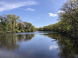
The Westons Mill Pond is a dammed section of the Lawrence Brook. The dam is located in the Westons Mills section of East Brunswick, New Jersey, United States, but the pond also borders the city of New Brunswick and North Brunswick Township. It is one of a series of dams on the Lawrence Brook. The Westons Mill Pond Dam is the dam that controls reservoir output. The Westons Mill Pond is available for boating, although gasoline motors are prohibited due to the highly sensitive wildlife ecosystems found there.

The King's Highway Historic District covers the portions of U.S. Route 206 and New Jersey Route 27 in New Jersey that connect Lawrenceville with Kingston through Princeton. This historic roadway dates to colonial times and was a portion of the King's Highway that was laid out by order of Charles II of England to connect Boston with Charleston. It is lined with many institutions and sites that have played an important role in the History of the United States, including Princeton University and the Princeton Theological Seminary.
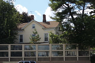
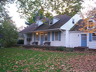
The Edward S. Kearney House is a historic house located at 9 New Jersey Route 18 in the Westons Mills section of East Brunswick in Middlesex County, New Jersey. It was added to the National Register of Historic Places on April 6, 1979, for its significance in architecture and commerce, one of only two historic taverns in the township.