
Monroe Township is a township in southern Middlesex County, New Jersey, United States. It is part of the outer-ring suburbs of the New York Metropolitan area. The township is also centrally located within the Raritan Valley region. As of the 2010 United States Census, the township's population was 39,132, reflecting an increase of 11,133 (+39.8%) from the 27,999 counted in the 2000 Census, which had in turn increased by 5,744 (+25.8%) from the 22,255 counted in the 1990 Census.
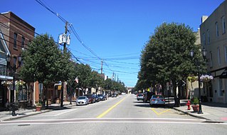
South Amboy is a suburban city in Middlesex County, New Jersey, on the Raritan Bay. As of the 2010 United States Census, the city's population was 8,631, reflecting an increase of 718 (+9.1%) from the 7,913 counted in the 2000 Census, which had in turn increased by 50 (+0.6%) from the 7,863 counted in the 1990 Census.
U.S. Route 130 is a U.S. Highway that is a spur route of US 30, located completely within the state of New Jersey. It is signed with north and south cardinal directions, following a general northeast–southwest diagonal path, with "north" corresponding to the general eastward direction and vice versa. The route runs 83.46 mi (134.32 km) from Interstate 295 (I-295) and US 40 at Deepwater in Pennsville Township, Salem County, where the road continues south as Route 49, north to US 1 in North Brunswick Township, Middlesex County, where Route 171 continues north into New Brunswick. The route briefly runs concurrent with US 30 near Camden, about one-third of the way to New Brunswick. The road runs within a close distance of I-295 south of Bordentown and a few miles from the New Jersey Turnpike for its entire length, serving as a major four- to six-lane divided local road for most of its length. US 130 passes through many towns including Penns Grove, Bridgeport, Westville, Camden, Pennsauken, Burlington, Bordentown, Hightstown, and North Brunswick.
The United New Jersey Railroad and Canal Company (UNJ&CC) was a railroad company which began as the important Camden & Amboy Railroad (C&A), whose 1830 lineage began as one of the eight or ten earliest permanent North American railroads, and among the first common carrier transportation companies whose prospectus marketed an enterprise aimed at carrying passengers fast and competing with stagecoaches between New York Harbor and Philadelphia-Trenton. Among the other earliest chartered or incorporated railroads, only the Mohawk and Hudson Railroad and Baltimore and Ohio Railroad were chartered with passenger services in mind. Later, after mergers, the UNJ&CC became a subsidiary part of the Pennsylvania Railroad (PRR) system in New Jersey by the later merger and acquisition of several predecessor companies in 1872; these purchases also included the PRR's main line to New York City. Prior to 1872, its main lines were the Camden and Amboy Rail Road and Transportation Company, the first railroad in New Jersey and one of the first railroads in the United States.

Atco is an unincorporated community in Waterford Township in Camden County, New Jersey, United States. It is part of the Philadelphia-Camden metropolitan area, located 16 miles (26 km) southeast of Camden. Though generally considered part of Waterford Township, a small section of the southern edge of Atco is located in Winslow Township.

Peter Dumont Vroom, an American Democratic Party politician, served as the ninth Governor of New Jersey and as a member of the United States House of Representatives for a single term, from 1839–1841.
County Route 551 is a county highway in the U.S. state of New Jersey. The highway extends 34.57 miles (55.64 km) from Pennsville-Salem Road in Pennsville Township to Penn Street in Camden.

Roebling is a station on the River Line light rail system, located in Roebling, New Jersey. The station opened on March 15, 2004 together with the line. A previous station, operated by the Pennsylvania Railroad, was located at the site from around 1907 until the 1950s. The station consists of one side platform serving the single-track line; an adjacent parking lot originally intended to support nearby developments is used by local commuters.

North Pemberton is a disused railway station located in Pemberton Township, Burlington County, New Jersey, United States. The station was built in 1892 by John S. Rogers and added to the National Register of Historic Places on May 23, 1978. The station became inactive in 1969 when rail service between Pemberton and Camden ended. The Township of Pemberton now owns the station and operates it as the North Pemberton Railroad Station Museum, a museum of regional history and a Welcome and Information Center for both the Pinelands and the Pemberton area.

Applegarth is an unincorporated community located within Monroe Township in Middlesex County, New Jersey, United States. The settlement is located in the southern portion of the township and is traversed by the road of the same name, Applegarth Road. At the location of the original settlement, at the intersection of Applegarth, Wycoffs Mills, and Old Church Roads, there is a restaurant, farmland, and the Applegarth Fire Department. Further north along Applegarth Road are housing developments, age-restricted communities, and two elementary schools: Applegarth and Oak Tree.

Cranbury Station is an unincorporated community located within Cranbury Township in Middlesex County, New Jersey, United States. The area immediately around the site of the former railroad station along the Camden and Amboy Railroad contains agricultural businesses and small homes. Hightstown-Cranbury Station Road is the main road through the settlement paralleling the railroad and Station Road, County Route 615 as a major road heading east and west through the area. Modern warehouses line Station Road and the nearby New Jersey Turnpike west of the station while large housing developments are located east of here in Monroe Township.

Hoffman is an unincorporated community located within Monroe Township in Middlesex County, New Jersey, United States. The settlement is located at the site of a former railroad station on the Freehold and Jamesburg Agricultural Railroad. Today, most of the area is made up of homes and housing developments along Hoffman Station Road and Gravel Hill-Spotswood Road. Forestland and the Manalapan Brook valley make up the remainder of the area.

East Spotswood, also known as the settlement of Old Bridge, is an unincorporated community located within East Brunswick, New Jersey and Old Bridge townships in Middlesex County, New Jersey, United States. The area is made up of homes, businesses, and wetlands for the South River. The area is located at the junction of New Jersey Route 18, County Route 527, the western end of CR 516, and the Bordentown and South Amboy Turnpike. The still-active Jamesburg Branch of the former Camden & Amboy Railroad also runs through the community.

Ernston is a neighborhood in Sayreville in Middlesex County, New Jersey, United States. It was a stop on the Camden and Amboy Railroad. In 1876, when the newly-formed Township of Sayreville was created from approximately 14 square miles (36 km2) of South Amboy's surroundings, Ernston was consolidated with Morgan, Melrose, and Sayre's Village under one municipal government.
Half Acre is an unincorporated community located within Monroe Township in Middlesex County, New Jersey, United States. The settlement is located roughly at the intersection of Prospect Plains Road and Half Acre Road in the center of the township. Some single-family homes and small businesses are located along those two roads and Cranbury-Half Acre Road but most of the area is made up of age-restricted housing developments including Concordia, Clearbrook Park, Greenbriar at Whittingham, and Encore at Monroe.
Tracy is an unincorporated community located within Monroe Township in Middlesex County, New Jersey, United States. The settlement is located at the site of a former station on the Freehold and Jamesburg Agricultural Railroad in the southeastern edge of the township. Most of the area is forestland with some homes and light commercial businesses located along Federal Road and Tracy Station Road.

Old Church is an unincorporated community located within Monroe Township in Middlesex County, New Jersey, United States. The settlement is named for a Presbyterian community that settled on the site but relocated to Cranbury c. 1740. Originally, the area was farmland. One of the farms in the area was the Dey Farm, in existence since the founding of Monroe Township in 1838 and the site of a command post used by George Washington during the Battle of Monmouth in 1778. Starting in 2004, the area experienced a major change from its agricultural roots to single-family residences on the south side of the area and age-restricted communities to the north. This redevelopment also caused the severing of the main north–south road, Old Church Road and the extension of Federal Road which formerly had its western end at Old Church Road to Applegarth Road. The a farmhouse named England House was moved 4,000 feet (1,200 m) to the Dey Farm site to preserve the area's history prior to the construction of the new houses in 2004.


