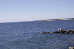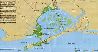
Jamaica Bay is an estuary on the southern portion of the western tip of Long Island, in the U.S. state of New York. The estuary is partially man-made, and partially natural. The bay connects with Lower New York Bay to the west, through Rockaway Inlet, and is the westernmost of the coastal lagoons on the south shore of Long Island. Politically, it is primarily divided between the boroughs of Brooklyn and Queens in New York City, with a small part touching Nassau County.

New York Harbor is at the mouth of the Hudson River where it empties into New York Bay near the East River tidal estuary, and then into the Atlantic Ocean on the East Coast of the United States.

New York Bay is the large tidal body of water in the New York–New Jersey Harbor Estuary where the Hudson River, Raritan River, and Arthur Kill empty into the Atlantic Ocean between Sandy Hook and Rockaway Point.

Gateway National Recreation Area is a 26,607-acre (10,767 ha) U.S. National Recreation Area in New York City and Monmouth County, New Jersey. It provides recreational opportunities that are not commonly found in a dense urban environment, including ocean swimming, bird watching, boating, hiking and camping. More than 8.7 million people visited Gateway National Recreation Area in 2022, making it the fourth-most visited unit of the National Park Service.

The Narrows is the tidal strait separating the boroughs of Staten Island and Brooklyn in New York City. It connects the Upper New York Bay and Lower New York Bay and forms the principal channel by which the Hudson River empties into the Atlantic Ocean. It has long been considered to be the maritime "gateway" to New York City and historically has been one of the most important entrances into the harbors of the Port of New York and New Jersey.

Raritan Bay is a bay located at the southern portion of Lower New York Bay between the U.S. states of New York and New Jersey and is part of the New York Bight. The bay is bounded on the northwest by New York's Staten Island, on the west by Perth Amboy, New Jersey, on the south by the Raritan Bayshore communities in the New Jersey counties of Middlesex and Monmouth, and on the east by Sandy Hook Bay. The bay is named after the Raritans, a branch of the Lenape tribe who lived in the vicinity of the bay and its river for thousands of years, prior to the arrival of Dutch and English colonists in the 17th century.

The New York–New Jersey Harbor Estuary, also known as the Hudson-Raritan Estuary, is in the northeastern states of New Jersey and New York on the East Coast of the United States. The system of waterways of the Port of New York and New Jersey forms one of the most intricate natural harbors in the world and one of the busiest ports of the United States. The harbor opens onto the New York Bight in the Atlantic Ocean to the southeast and Long Island Sound to the northeast.

The New York–New Jersey Harbor Estuary has a variety of flora and fauna. Much of the harbor originally consisted of tidal marshes that have been dramatically transformed by the development of port facilities. The estuary itself supports a great variety of thriving estuarine aquatic species; contrary to popular stereotypes, New York Harbor and its adjacent, interdependent waters are very much alive, and steadily recovering from pollution; ecologically it is true that these waters were once dead or extremely toxic but after 45 years of cleaning the estuary is in a much better state than it has been in a hundred years. Tidal flow occurs as far north as Troy, over 150 miles away. The salt front can reach Poughkeepsie in drought conditions and is present in the lower reaches of the Raritan River for most of the year.

Hoffman Island is an 11-acre (4.5 ha) artificial island in the Lower New York Bay, off the South Beach of Staten Island, New York City. A smaller, 4-acre (1.6 ha) artificial island, Swinburne Island, lies immediately to the south. Created in 1873 upon the Orchard Shoal by the addition of landfill, the island is named for former New York City mayor (1866–1868) and New York Governor (1869–1871) John Thompson Hoffman.
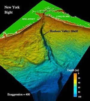
The New York Bight is the geological identification applied to a roughly triangular indentation, regarded as a bight, along the Atlantic coast of the United States that extends northeasterly from Cape May Inlet in New Jersey to Montauk Point on the eastern tip of Long Island. As the result of direct contact with the Gulf Stream along the coast of North America, the coastal climate of the bight area is temperate.

The Port of New York and New Jersey is the port district of the New York-Newark metropolitan area, encompassing the region within approximately a 25-mile (40 km) radius of the Statue of Liberty National Monument.

Ambrose Channel is the only shipping channel in and out of the Port of New York and New Jersey. The channel is considered to be part of Lower New York Bay and is located several miles off the coasts of Sandy Hook, New Jersey, and Breezy Point, New York. Ambrose Channel terminates at Ambrose Anchorage, just south of the Verrazzano Narrows Bridge, the gateway to New York Harbor, where it becomes known as the Anchorage Channel. It is named for John Wolfe Ambrose, an engineer from New York.

The Raritan Bayshore is a region in central sections in the state of New Jersey. It is the area around Raritan Bay from The Amboys to Sandy Hook, in Middlesex and Monmouth counties, including the towns of Perth Amboy, South Amboy, Sayreville, Old Bridge, Matawan, Aberdeen, Keyport, Union Beach, Hazlet, Keansburg, Middletown, Atlantic Highlands, and Highlands. It is the northernmost part of the Jersey Shore, located just south of New York City. At Keansburg is a traditional amusement park while at Sandy Hook are found ocean beaches. The Sadowski Parkway beach area in Perth Amboy, which lies at the mouth of the Raritan River, was deemed the "Riviera of New Jersey" by local government. In recent years many of the beaches on the Bayshore area have been rediscovered and upgraded.
American Princess Cruises, based in Neponsit, Queens, United States under the TWFM Ferry Service, Inc., offers ferry, sightseeing, and yacht charter excursions in Long Island, New Jersey, and New York City. It is one of several private ferry operators in the Port of New York and New Jersey.
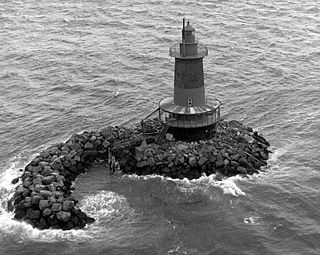
West Bank Light, officially West Bank Front Range Light, is a lighthouse in Lower New York Bay, within New York City, and acts as the front range light for the Ambrose Channel. It is currently active and not open to the public. The tower was built in 1901 and heightened in 1908. Staten Island Light serves as the rear range light.

The South Beach–Franklin Delano Roosevelt Boardwalk, alternately referred to as the FDR Boardwalk or the South Beach Boardwalk, is a boardwalk facing the Lower New York Bay on the East Shore of Staten Island, one of the five boroughs of New York City. The boardwalk is the main feature of a public park that stretches from Fort Wadsworth and the Verrazzano-Narrows Bridge to Miller Field, both part of the Gateway National Recreation Area. The park also contains numerous recreational facilities, including a skate park.
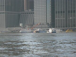
Pier 11/Wall Street is a pier providing slips to ferries and excursion boats on the East River in the Port of New York and New Jersey. It is located east of South Street and FDR Drive just south of Wall Street in Lower Manhattan, New York City. The ferry terminal has five landings, each with two berths, and is used by four privately owned companies.
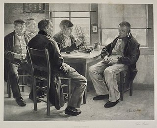
Sandy Hook Pilots are licensed maritime pilots that are members of the Sandy Hook Pilots Association for the Port of New York and New Jersey, the Hudson River, and Long Island Sound. Sandy Hook pilots guide oceangoing vessels, passenger liners, freighters, and tankers in and out of the harbor. The peninsulas of Sandy Hook, and Rockaway in Lower New York Bay define the southern entrance to the port at the Atlantic Ocean.
NYC Ferry is a public network of ferry routes in New York City operated by Hornblower Cruises. As of August 2023, there are six routes, as well as one seasonal route, connecting 25 ferry piers across all five boroughs. NYC Ferry has the largest passenger fleet in the United States with a total of 38 vessels, providing between 20 and 90 minute service on each of the routes, depending on the season.

The Richard K. Fox, first named Lillie, was a 19th-century pilot boat built in 1876 for Boston Pilots. She was designed by model by Dennison J. Lawlor. She was one of the most graceful and attractive of the Boston pilot-boats and represented a trend toward deep-bodied boats. She was later sold to the New York pilots and renamed Richard K. Fox in honor of the famous sportsman and publisher of the Police Gazette. In the age of steam, she was sold in 1896 to the Marine Hospital Service.


