
The Quabbin Reservoir is the largest inland body of water in Massachusetts, and was built between 1930 and 1939. Along with the Wachusett Reservoir, it is the primary water supply for Boston, 65 miles (105 km) to the east, and 40 other cities and towns in Greater Boston. The Quabbin also supplies water to three towns west of the reservoir and acts as backup supply for three others. By 1989, it supplied water for 2.5 million people, about 40% of the state's population at the time. It has an aggregate capacity of 412 billion US gallons (1,560 GL) and an area of 38.6 square miles (99.9 km2).

The New Croton Dam is a dam forming the New Croton Reservoir, both parts of the New York City water supply system. It stretches across the Croton River near Croton-on-Hudson, New York, about 22 miles (35 km) north of New York City.
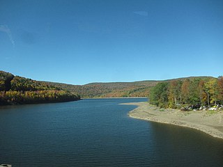
The Pepacton Reservoir, also known as the Downsville Reservoir, is a reservoir in Delaware County, New York on the East Branch of the Delaware River in the Catskill Mountains of New York. Part of the New York City water supply system, it was formed by the construction of Downsville Dam, and impounds over one-quarter of the East Branch's flow.

The Cannonsville Reservoir is a reservoir in the New York City water supply system in Delaware County, New York. It was formed by construction of the Cannonsville Dam on its west end, which impounded over half of the West Branch of the Delaware River. Lying on the western part of the Delaware Watershed, it is the westernmost of New York City's reservoirs. It was placed in service in 1964, and is the most recently constructed New York City-owned reservoir.

The Kensico Reservoir is a reservoir spanning the towns of Armonk and Valhalla, New York, located 3 miles (5 km) north of White Plains. It was formed by the original earth and gravel Kensico Dam constructed in 1885, which impounded waters from the Bronx and Byram rivers. In 1917, a new masonry dam was completed, replacing the old dam and expanding the water supply by bringing water from the Catskill Mountains over a distance of more than 100 miles.

The West Branch Reservoir is a reservoir in the New York City water supply system. Formed by impounding the upper reaches of the West Branch of the Croton River, it is located in the Putnam County, New York, towns of Kent, and Carmel, about 50 miles (80 km) north of New York City.
The Boyds Corner Reservoir is a small reservoir in Putnam County, New York. It is in the town of Kent, New York, and is about 50 miles north of New York City. It is the northernmost reservoir in the Croton River watershed, but is not part of the New York City water supply system's Croton Watershed. and was formed by impounding the middle of the West Branch of the Croton River, submerging the village of Boyds Corner.

The Amawalk Reservoir is a small reservoir in the New York City water supply system located in central-northern Westchester County, New York. It is located at the intersection of U.S. Route 202 and New York State Route 35 in the town of Somers, and is over 32 miles north of New York City. Part of the system's Croton Watershed, it was formed by impounding the middle of the Muscoot River, one of the tributaries of the Croton River. This reservoir was put into service in 1897, and was named after the original community of Amawalk, New York, which was inundated by the reservoir and relocated near the dam.

The Bog Brook Reservoir is a 379-acre (153 ha) reservoir in the Croton Watershed in southern New York State, part of the New York City water supply system. It is located in the town of Southeast in Putnam County, approximately 38 miles (61 km) north of New York City. It was formed by the damming of Bog Brook, a small tributary of the East Branch of the Croton River. The reservoir was put into service in 1892, making it one of the older in the system.

The Cross River Reservoir is a reservoir in the New York City water supply system located directly east and north of the northern Westchester County, New York, Hamlet of Katonah. Part of the system's Croton Watershed, it lies within the towns of Bedford, Lewisboro, and Pound Ridge, about 1 mile (1.6 km) east of the village of Katonah, and over 25 mi (40 km) north of New York City. It was constructed around the start of the 20th century by impounding the Cross River, a tributary of the Croton River, which eventually flows into the Hudson River.
The Croton Falls Reservoir is a reservoir in the New York City water supply system in the Putnam County, New York townships of Carmel, and Southeast, roughly 50 miles (80 km) north of New York City. Part of the system's Croton Watershed, it was formed by impounding the West Branch and Middle Branch of the Croton River, tributaries of the Croton River, which flows into the Hudson River.
The Diverting Reservoir is a reservoir in the New York City water supply system in the town of Southeast, New York, in Putnam County immediately south of the village of Brewster, New York. Part of the system's Croton Watershed, it lies about 50 miles (80 km) north of New York City. Construction impounding the East Branch Croton River began early in the 20th century and was completed by 1911.
The Muscoot Reservoir is a reservoir in the New York City water supply system in northern Westchester County, New York, located directly north of the village of Katonah. Part of the system's Croton Watershed, it is 25 miles north of the City.

The New Croton Reservoir is a reservoir in Westchester County, New York, part of the New York City water supply system lying approximately 22 miles (35 km) north of New York City. It is the collecting point for water from all reservoirs in the Croton Watershed.

The Croton River is a river in southern New York with three principal tributaries: the West Branch, Middle Branch, and East Branch. Their waters, all part of the New York City water supply system, join downstream from the Croton Falls Reservoir. Together, their waters and the reservoirs linked to them represent the northern half of the New York City water system's Croton Watershed.

The Ware River is a 35.4-mile-long (57.0 km) river in central Massachusetts. It has two forks, its West Branch, which begins in Hubbardston, Massachusetts, and its East Branch, which begins in Westminster, Massachusetts. The Ware River flows southwest through the middle of the state, joins the Quaboag River at Three Rivers, Massachusetts, to form the Chicopee River on its way to the Connecticut River.
[[File:Crotonrivermap.png|thumb|right|Map of the Croton River watershed. Note that this is not identical with the New York City water supply system's "Croton Watershed"{{efn|Numerous small natural lakes and ponds, as well as large Lake Mahopac, are part of the Croton River's watershed but not part of New York City’s supply system. A map of the actual Croton Watershed is found here. ]]
This page is about the Croton River watershed, a hydrological feature. For the component of the New York City water supply system with a similar name, see Croton Watershed
The West Branch Croton River is a tributary of the Croton River in Putnam and Westchester counties in the state of New York. It lies within the Croton River watershed and is part of the New York City water supply system's Croton Watershed.
The Muscoot River is a short tributary of the Croton River in Putnam and Westchester counties in the state of New York. Approximately 6 mi (9.7 km) long and running north-to-south, it lies within the Croton River watershed and is part of the New York City water supply system's Croton Watershed.


