Brewster is a village and the principal settlement within the town of Southeast in Putnam County, New York. Brewster's population was 2,508 at the 2020 census. The village, which is the most densely populated portion of the county, was named for two early farmer landowners, Walter and James Brewster, who donated land for the Brewster railroad station in 1848.[2]
The village of Brewster derives its name from that of the landowner, Walter Brewster, who invited the New York and Harlem Railroad to build a depot on his property in 1848. Brewster's Station, New York (sometimes just "Brewster's"), appeared on maps,[3] on postcards, and in directories of Putnam County throughout the second half of the 19th century. It was officially incorporated as the Village of Brewster, New York, in 1894.
In 1886, historian William Smith Pelletreau published The History of Putnam County, New York. In his second chapter on the town of Southeast, he wrote: "The land now [1886] embraced within the limits of the village of Brewster consists of a farm which was sold by the commissioners of forfeiture to Peleg Bailey, in 1781. A portion of it afterward passed into the possession of Bailey Howes, his grandson, who sold 98 acres to Gilbert Bailey on April 1, 1833. Two other tracts containing 39 acres were sold to Gilbert Bailey, by William P. Downs and Frederick Parks in 1838. On the 17th of February, 1848, Gilbert Bailey sold the whole tracts, estimated at 134 acres, to James and Walter F. Brewster, for the sum of $8,000."[4]
"At the time of the purchase, the New York and Harlem Railroad was finished and trains were running as far as Croton Falls. The road was surveyed as far as Pawling, and the prospect of its being continued to that point seemed certain, and to the new purchasers of the farm it seemed just the place for a station."[4]
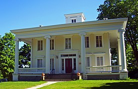
"The New York and Harlem Railroad was finished to this place and the depot was built in that year, and what is now [1886] the Main street was opened, for the purpose of allowing the stages from Danbury to come to the station. Previous to this the firm of Crosby and DeForest had run a line of four horse stages to Croton Falls, from Danbury. The first new house in the place was built by Walter F. Brewster, in 1850 and stood in front of the present [1886] Methodist church."[4] That house, now listed as the Walter Brewster House on the New York State and national historic registers, is owned by the Landmark Preservation Society of Southeast.
"The Harlem Railroad's extension of its mileage in 1849 proved advantageous to Mr. Brewster, who needed all sorts of materials in his building activities. Large shipments were billed simply to 'Brewster's Station' for lack of better designation. This is the apparent origin of the village's name, which many years ago was shortened to Brewster."[2]
Post offices
Jonathan F. Frost was the first Postmaster of the Brewster's Station post office, which operated from October 25, 1850, through April 28, 1883.[5]
During this period in American history, post offices were frequently located in the stores or businesses owned by the individuals who served as postmasters. This held true in the village of Brewster for the next century.
In 1863, the Brewster Station post office relocated to the A.F. Lobdell General Store, across from the railroad station, the present location of the Avery Building at 12–18 Main Street. Alexander F. Lobdell, the store's proprietor, was appointed postmaster by President Abraham Lincoln and was reappointed by Presidents Grant, Hayes, Garfield and Arthur, continuing as Brewster's postmaster until 1887.[6] The Brewster post office began operation on April 28, 1883, removing the word "Station" in its identity and postmarks.[5]
In 1887, the post office relocated to the Brewster Standard building, the present location of the Sprague Building at 31 Main Street. In 1886, Emerson W. Addis, publisher of the Brewster Standard weekly newspaper, became the postmaster and held that position until 1916.[6]
In 1916, the post office moved to new quarters on Park Street, between Main Street and Marvin Avenue, into the Rundall Building, and John Thorp became the new postmaster.[6]
In 1923, Ralph Diehl, proprietor of the Brewster Bakery, became postmaster, and the post office was moved to his baking plant on Progress Street in 1927. Howard Tuttle later became the postmaster, holding the position until 1934 when Seth Howes was appointed. In 1936, the post office relocated to the building now occupied by the Eagle Eye Thrift Shop at 65 Main Street.
Mr. Howes held the office until 1958 when John F. Larkin Jr. was made acting postmaster. He was later promoted to the full title of postmaster.[6]
On July 17, 1966, the post office relocated to a new brick building on Main Street, where it remained for the next three decades. Mr. Larkin retired in 1972 and was succeeded by Earl Tuttle, who became the last Southeast resident to hold the position of postmaster since that time. Mr. Tuttle retired in 1985.[6]
The new facility was the first Brewster post office to occupy a space that was specifically designed for the purpose, rather than being retrofitted from some previous use. It had a separate lobby to house post office boxes, a loading dock at the rear of the building and a postal inspector's separate entrance and hallway with one-way glass for observing postal workers and the public.
In the mid-1990s, the Main Street facility closed and a new post office opened at its present location at 3 Mount Ebo Road North outside the village limits in the town of Southeast. Although the new facility is more than 3 miles (5km) from the center of Brewster, it still retains the designation and postmark "Brewster 10509".
"Brewster" vs. "Southeast"
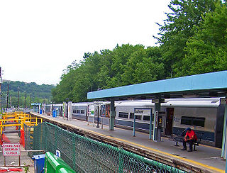
View of village from train station
The town of Southeast contains the village of Brewster. In New York, villages are always within one or more towns, and village jurisdiction may override that of similar town laws. Residents of the town often refer to the entire municipality as "Brewster", as that is the postal designation.
The railroad station in downtown Brewster, owned in turn by the New York Central, Penn Central, Conrail, and now Metro-North Railroad, has always been known as "Brewster" because it is located in the village of Brewster. Since 1849, rail customers coming to Southeast only knew they were travelling to "Brewster". Over time, the name Southeast was all but forgotten.
The new depot that was built in Southeast, just a quarter mile north of the village, was first named "Brewster North". That second depot has since been renamed "Southeast".
Before 1962, there were several local post offices throughout the town of Southeast, located near larger concentrations of residences and businesses. The last of these, Southeast's Putnam Lake post office, closed in 1968.[5] When a new post office opened at 16 Main Street in Brewster on July 17, 1966,[6] even before Interstate 84 and Interstate 684 were constructed, it was named Brewster and given the zip code 10509.[5] The two highways brought massive population increases, nearly tripling the number of residents in Southeast in a matter of about 20 years. As a result, "Brewster, New York 10509" was part of the return address of every resident of Southeast and Brewster. Probably because of the proximity to the Brewster train station, the highway exit signs of I-84 and I-684 say "Brewster". Road signs in White Plains, Danbury, Carmel and other nearby towns all direct travelers to Brewster. Only the town's "Welcome to Southeast" signs acknowledge the town's existence.
The post office has relocated out of the village and removed "Brewster" from the building. The zip code is still 10509 but does not have the name of the municipality on its exterior of the building. Residents who live in the town still use "Brewster 10509" for their return address, and the post office still uses "Brewster" rather than "Southeast" in its postmarks.
As of the census[9] of 2020, there were 2,508 people residing in Brewster. There were 701 housing units at an average density of 1,851.6 per square mile (714.9/km2). The racial makeup of the village was 55.98% Hispanic or Latino, 36.61% non-Hispanic white, 2.59% African American, .42% Native American, 3.22% Asian, .04% from other races, and 1.13% from two or more races.
At the 2010 census, the village had the highest concentration of Guatemalans in the US, comprising 38.16% of the village population.[citation needed]
The households, out of which 26.5% had children under the age of 18 living with them, 33.9% were married couples living together, 11.9% had a female householder with no husband present, and 47.4% were non-families. 34.2% of all households were made up of individuals, and 10.0% had someone living alone who was 65 years of age or older. The average household size was 2.52 and the average family size was 3.08.
In the village, the population was spread out, with 20.4% under the age of 18, 11.9% from 18 to 24, 41.4% from 25 to 44, 16.3% from 45 to 64, and 10.0% who were 65 years of age or older. The median age was 33 years. For every 100 females there were 131.0 males. For every 100 females age 18 and over, there were 128.4 males.
The median income for a household in the village was $42,750, and the median income for a family was $48,393. Males had a median income of $28,793 versus $28,929 for females. The per capita income for the village was $21,865. About 9.0% of families and 14.5% of the population were below the poverty line, including 12.4% of those under age 18 and 12.1% of those age 65 or over.
John McCloy (1875–1945), Lieutenant commander and a United States Navy Medal of Honor recipient[44]
Related Research Articles
Putnam County is a county located in the U.S. state of New York. As of the 2020 census, the population was 97,668. The county seat is Carmel, located within one of six towns comprising the county. The county is part of the Hudson Valley region of the state.
Gila Bend, founded in 1872, is a town in Maricopa County, Arizona, United States. The town is named for an approximately 90-degree bend in the Gila River, which is near the community's current location. As of the 2020 census, the population of the town was 1,892.
Grovetown is a city in Columbia County, Georgia, United States. It is part of the Augusta metropolitan area and the Central Savannah River Area. The 2019 population estimate was 15,152. The mayor is Gary Jones.
Southeast is a town in Putnam County, New York, United States, so named for its location in the southeastern corner of the county. The population was 18,058 at the 2020 census. The town as a whole is informally referred to as Brewster, the town's principal settlement; the latter is also an incorporated village within the town's borders. Interstate 84, Interstate 684, U.S. Route 202, US Route 6, and NY 22 are the primary routes through the town.
Delanson is a village in Schenectady County, New York, United States. The population was 377 at the 2010 census. Delanson is in the southeastern portion of the town of Duanesburg.
Ardsley is a village in Westchester County, New York, United States. It is part of the town of Greenburgh. The village's population was 4,452 at the 2010 census. The mayor of Ardsley is Nancy Kaboolian.
Pleasantville is a village in the town of Mount Pleasant, in Westchester County, New York, United States. It is located 30 miles north of Manhattan. The village population was 7,513 at the 2020 census. Pleasantville is home to the secondary campus of Pace University and to the Jacob Burns Film Center. Most of Pleasantville is served by the Pleasantville Union Free School District, with small parts of northern Pleasantville served by the Chappaqua Central School District. The village is also home to the Bedford Road School, Pleasantville Middle School, and Pleasantville High School. The region of Pleasantville commonly referred to as "The Flats" is mostly served by the Mount Pleasant Central School district.
Southeast station is a commuter rail stop on the Metro-North Railroad's Harlem Line, located in Southeast, New York. It is the terminus of the Harlem Line electrified service, and with the exception of rush hour service, passengers heading to stations further north to Wassaic have to transfer here to diesel powered service.
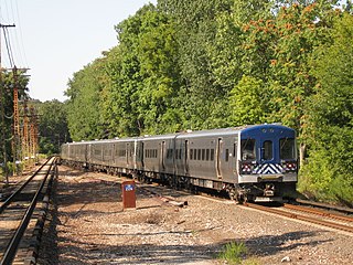
Brewster station is a commuter rail stop on the Metro-North Railroad's Harlem Line, located in Brewster, New York.
The Harlem Line is an 82-mile (132 km) commuter rail line owned and operated by the Metro-North Railroad in the U.S. state of New York. It runs north from New York City to Wassaic, in eastern Dutchess County. The lower 53 miles (85 km) from Grand Central Terminal to Southeast, in Putnam County, is electrified with a third rail and has at least two tracks. The section north of Southeast is a non-electrified single-track line served by diesel locomotives. Before the renaming of the line in 1983, it eventually became the Harlem Division of the New York Central Railroad. The diesel trains usually run as a shuttle on the northern end of the line, except for rush-hour express trains in the peak direction.
The New York and Putnam Railroad, nicknamed the Old Put, was a railroad line that operated between the Bronx and Brewster in New York State. It was in close proximity to the Hudson River Railroad and New York and Harlem Railroad. All three came under ownership of the New York Central system in 1894. The railroad was abandoned starting in 1958, and most of the former roadbed has been converted to rail trail use.
Croton Falls station is a commuter rail stop on the Metro-North Railroad's Harlem Line, located in North Salem, New York.
Goldens Bridge station is a commuter rail stop on the Metro-North Railroad's Harlem Line, located in Lewisboro, New York.
Mount Kisco station is a commuter rail stop on the Metro-North Railroad's Harlem Line, located in Mount Kisco, New York, United States.
New York State Route 312 (NY 312) is a short state highway connecting U.S. Route 6 (US 6) and NY 22 within the town of Southeast in Putnam County, New York. It allows indirect access to the village of Brewster from Interstate 84 (I-84), and is often heavily used by local residents at rush hour in preference to the more complicated nearby access to I-684. The western terminus of the route is at US 6 roughly 2 miles (3.2 km) northwest of Brewster, and the eastern is in the hamlet of Sears Corners.
The Metro-North Railroad's Beacon Line is a non-revenue line connecting the railroad's three revenue lines east of the Hudson River. From west to east, the lines that connect are Hudson Line, Harlem Line, and the Danbury Branch of the New Haven Line. It was purchased by Metro-North in 1995 for $4.2 million from Maybrook Properties, a subsidiary of the Housatonic Railroad, to preserve it for future use, training, and equipment moves. Maybrook Properties purchased the line from Conrail after Conrail withdrew from the Danbury, Connecticut, freight market in 1992.
The Walter Brewster House is located on Oak Street in Brewster, New York, United States. It was built in the Greek Revival style around 1850 by Brewster, who founded the village that today bears his name.
The First National Bank of Brewster building, later Southeast Town Hall, is located on Main Street next to the train station in Brewster, New York, United States. It is a brick Queen Anne-style building constructed in 1886 currently used as offices for the Town of Southeast, of which Brewster is part.
The Old Southeast Town Hall is located on Main Street in Brewster, New York, United States. Built in 1896, it served as the main office of the Town of Southeast, which surrounds and includes Brewster. In 1964, the town's clerk and supervisor moved to the recently closed First National Bank of Brewster's building down the street.
The Old Southeast Church is located at the end of a short dirt road leading from NY 22 in the Town of Southeast, New York, United States, a few miles north of the village of Brewster. It is a wooden building formerly used by a Presbyterian congregation. Built in the late 18th century and later modified following a fire, it is the oldest house of worship in Putnam County. Today many of its materials are intact but it is the subject of ongoing preservation efforts.
1 2 Brewster Through the Years 1848–1948, H. Wolff Book Manufacturing Co., New York 1948
↑ Beers 1867 Atlas "Atlas of New York and Vicinity from Actual Surveys by and Under the Direction of F. W. Beers, A. D. Ellis and G. G. Soule, New York 1867"
1 2 3 The History of Putnam County, New York. 1886. Reprinted by the Landmarks Preservation Committee of the Southeast Museum, Brewster, New York, 1975.
1 2 3 4 New York Postal History: The Post Offices and First Postmaster from 1775 to 1980 by John L. Kay and Chester M. Smith Jr., American Philatelic Society, 1982
1 2 3 4 5 6 The Town of Southeast 1788–1988 Edited by Suzanne F. Truran, John J. Dunford, Priscilla A. Truran – Publshed by the Town of Southeast, 1990
This page is based on this Wikipedia article Text is available under the CC BY-SA 4.0 license; additional terms may apply. Images, videos and audio are available under their respective licenses.


