
Putnam County is a county located in the U.S. state of New York. As of the 2020 census, the population was 97,668. The county seat is Carmel. Putnam County formed in 1812 from Dutchess County and is named for Israel Putnam, a hero in the French and Indian War and a general in the American Revolutionary War.

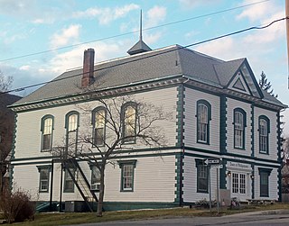
Cold Spring is a village in the town of Philipstown in Putnam County, New York, United States. The population was 1,986 at the 2020 census. It borders the smaller village of Nelsonville and the hamlets of Garrison and North Highlands. The central area of the village is on the National Register of Historic Places as the Cold Spring Historic District due to its many well-preserved 19th-century buildings, constructed to accommodate workers at the nearby West Point Foundry. The town is the birthplace of General Gouverneur K. Warren, who was an important figure in the Union Army during the Civil War. The village, located in the Hudson Highlands, sits at the deepest point of the Hudson River, directly across from West Point. Cold Spring serves as a weekend getaway for many residents of New York City.

Town of Kent is a town in Putnam County, New York, United States. The population was 12,900 at the 2020 census. The name is that of an early settler family. The town is in the north-central part of the Putnam County. Many of the lakes are reservoirs for New York City.

Nelsonville is a village located in the town of Philipstown in Putnam County, New York, United States. The population was 628 at the time of the 2010 census.
Philipstown is a town located in the western part of Putnam County, New York, United States. The population was 9,831 at the 2020 census.

Putnam Valley is a town in Putnam County, New York, United States. The population was 11,809 at the 2010 census. Its location is northeast of New York City, in the southwestern part of Putnam County.Putnam Valley calls itself the "Town of Lakes".

Southeast is a town in Putnam County, New York, United States, so named for its location in the southeastern corner of the county. The population was 18,058 at the 2020 census. The town as a whole is informally referred to as Brewster, the town's principal settlement; the latter is also an incorporated village within the town's borders. Interstate 84, Interstate 684, U.S. Route 202, US Route 6, and NY 22 are the primary routes through the town.

Hudson Highlands State Park is a non-contiguous state park in the U.S. state of New York, located on the east side of the Hudson River. The park runs from Peekskill in Westchester County, through Putnam County, to Beacon in Dutchess County, in the eastern section of the Hudson Highlands.

New York State Route 301 (NY 301), also known as the Hudson River Turnpike, is an intra-county state highway stretching across three-quarters of Putnam County, New York, in the United States. The western terminus of NY 301 is at an intersection with NY 9D in Cold Spring. Its eastern terminus is at a junction with NY 52 in Carmel. Along the way, NY 301 meets U.S. Route 9 (US 9) and the Taconic State Parkway and passes through Clarence Fahnestock State Park. The section of the route between NY 9D and US 9 is ceremonially designated as the Sergeant Albert Ireland Memorial Highway.
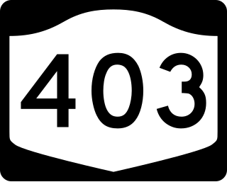
New York State Route 403 (NY 403) is a 2.27-mile-long (3.65 km) state highway located entirely within Putnam County. It connects NY 9D in Philipstown at its northern end to US 9 in the hamlet of Graymoor, where the Appalachian Trail crosses both highways. At that intersection, NY 403 is signed as a route to the Bear Mountain Bridge. Half of its length is uphill going south.

New York State Route 9D (NY 9D) is a north–south state highway in the Hudson Valley region of New York in the United States. It starts at the eastern end of the Bear Mountain Bridge at an intersection with U.S. Route 6 (US 6) and US 202 in Westchester County, and follows the eastern shore of the Hudson River for 25.21 miles (40.57 km) to a junction with US 9 north of the village of Wappingers Falls in Dutchess County. While US 9 follows a more inland routing between the bridge and Wappingers Falls, the riverside course of NY 9D takes the route through the village of Cold Spring and the city of Beacon.

New York State Route 311 (NY 311) is a state highway located entirely within Putnam County, New York, in the United States. It begins at NY 52 in Lake Carmel, and intersects Interstate 84 (I-84) shortly thereafter. It crosses NY 164 and NY 292 as it heads into the northeastern part of the county, finally curving east to reach its northern terminus at NY 22 just south of the Dutchess County line. The route passes several historical sites.

Garrison is a hamlet in Putnam County, New York, United States. It is part of the town of Philipstown, on the east side of the Hudson River, across from the United States Military Academy at West Point. The Garrison Metro-North Railroad station serves the town. Garrison was named after 2nd Lieutenant Isaac Garrison, who held a property lot on the Hudson River across from West Point and conducted a ferry service across the Hudson River between the two hamlets. Isaac and his son Beverly Garrison fought in the Battle of Fort Montgomery in 1777, were captured by the British and later set free.
Frederick Philipse, first Lord of the Manor of Philipseborough (Philipsburg) and patriarch of the Philipse family, was a Dutch immigrant to North America of Bohemian heritage. A merchant, he arrived in America as early as 1653. In 1662, he married Margaret Hardenbrook de Vries, a wealthy and driven widow. Together, and variously in league with slavers, pirates, and other undesirables, the couple amassed a fortune.
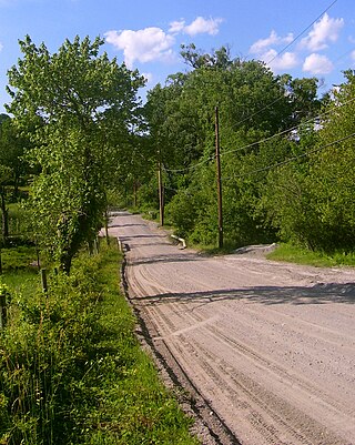
Old Albany Post Road is a 6.6-mile (10.6 km) dirt road in Philipstown, New York, one of the oldest unpaved roads still in use in the United States. It runs mostly north-south through the southeastern corner of the town, near the Putnam Valley town line. Starting from an intersection with Sprout Brook Road at Continental Village just north of the Putnam-Westchester county line, it ends at an oblique junction with US 9 east of Garrison.
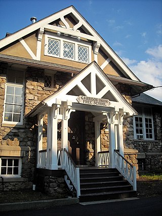
Garrison Union Free School, also referred to as just Garrison School, educates students from kindergarten through eighth grade in the eponymous school district, which covers the hamlet of Garrison and nearby areas of the towns of Philipstown and Putnam Valley in Putnam County, New York, United States. It is located on NY 9D near the center of the hamlet, right across from St. Philip's Church in the Highlands, where it was originally located when established in 1793.
The Hudson Highlands Multiple Resource Area is a Multiple Property Submission study supporting multiple listings in 1982 to the United States National Register of Historic Places. It originally included 58 properties spread over the counties of Dutchess, Putnam, Westchester, Orange and Rockland.
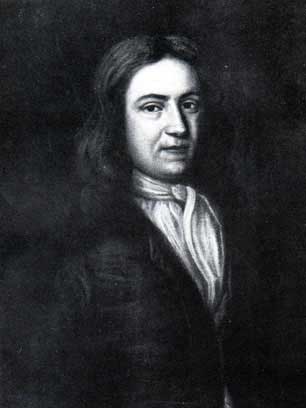
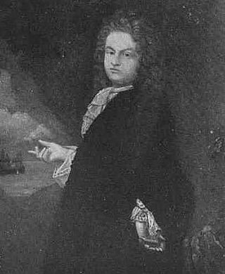
Adolphus Philipse (1665–1750) was a wealthy landowner of Dutch descent in the Province of New York. In 1697 he purchased a large tract of land along the east bank of the Hudson River stretching all the way to the east to the Connecticut border. Then known as the "Highland Patent" it became in time referred to as the Philipse Patent. After his death the Patent was inherited by his nephew, Frederick Philipse II, his only heir-at-law, who became the second Lord of the Manor of Philipsborough in Westchester County.

The Philipse Patent was a British royal patent for a large tract of land on the east bank of the Hudson River about 50 miles north of New York City. It was purchased in 1697 by Adolphus Philipse, a wealthy landowner of Dutch descent in the Province of New York, and in time became today's Putnam County.

Breakneck Brook, sometimes Breakneck Valley Brook, is a 1.7-mile-long (2.8 km) tributary of the Hudson River located entirely in the Putnam County town of Philipstown, New York, United States. It rises at Surprise Lake and flows southwest towards the Hudson from there, mostly through Hudson Highlands State Park. The name comes from Breakneck Ridge to its north.


