
Lincoln Park is a census-designated place (CDP) located in and governed by Fremont County, Colorado, United States. The CDP is a part of the Cañon City, CO Micropolitan Statistical Area. The population of the Lincoln Park CDP was 3,934 at the United States Census 2020. The Cañon City post office serves the area.

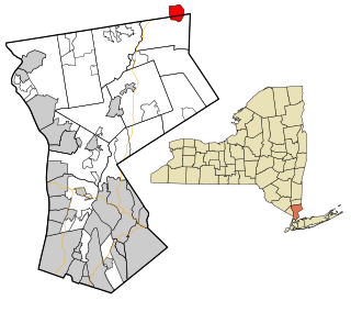
Hopewell Junction is a hamlet and census-designated place (CDP) in Dutchess County, New York, United States. The population was 1330 at the 2020 census. It is part of the Poughkeepsie–Newburgh–Middletown, NY Metropolitan Statistical Area as well as the larger New York–Newark–Bridgeport, NY-NJ-CT-PA Combined Statistical Area.

Brewster Hill is a hamlet located in the town of Southeast in Putnam County, New York, United States. As of the 2010 census, the population was 2,089.

Southeast is a town in Putnam County, New York, United States, so named for its location in the southeastern corner of the county. The population was 18,058 at the 2020 census. The town as a whole is informally referred to as Brewster, the town's principal settlement; the latter is also an incorporated village within the town's borders. Interstate 84, Interstate 684, U.S. Route 202, US Route 6, and NY 22 are the primary routes through the town.
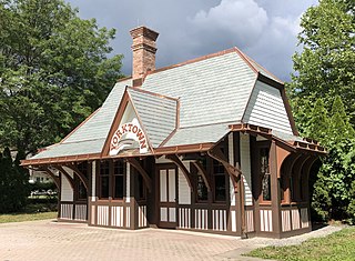
Yorktown Heights is a census-designated place (CDP) in the town of Yorktown in Westchester County, New York, United States. The population was 1,781 at the 2010 census.

Maple Heights-Lake Desire is a census-designated place (CDP) in King County, Washington, United States. At the 2010 census, the population was 3,152.
Peach Lake is a hamlet located mostly in the town of Southeast in Putnam County, New York, United States; a portion of the CDP is in the town of North Salem in Westchester County. As of the 2010 census, the population was 1,629.
Glassmanor is an unincorporated community and census-designated place in Prince George's County, Maryland, United States. As of the 2020 census, it had a population of 18,430. In the 1990 and 2000 censuses, the United States Census Bureau had placed Glassmanor and the adjacent community of Oxon Hill in the "Oxon Hill-Glassmanor" census-designated place for statistical purposes. Glassmanor was last delineated separately in 1980, when the CDP recorded a population of 7,751.

East Setauket is a hamlet and census-designated place (CDP) on Long Island, in the town of Brookhaven, Suffolk County, New York, United States. It was first listed as a CDP prior to the 2020 census. Before that it was part of the Setauket-East Setauket CDP. It includes the hamlet of South Setauket. within the CDP.

Putnam is an unincorporated community and census-designated place (CDP) in Marengo County, Alabama, United States. As of the 2020 census, its population was 172.
Summerfield is a census-designated place near Landover in Prince George's County, Maryland. As of the 2020 census, the population was 14,758. It is a suburb of Washington, D.C.
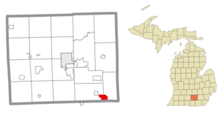
Vineyard Lake is an unincorporated community and census-designated place (CDP) in Jackson County in the U.S. state of Michigan. The CDP had a population of 980 at the 2010 census. It is located within Columbia Township to the west and Norvell Township to the east.
Noroton is a census-designated place (CDP) in the town of Darien, Fairfield County, Connecticut, United States. It occupies the southwest part of Darien, from the Metro-North Railroad in the north to Long Island Sound in the south. The southern half of the community occupies Noroton Neck, between Holly Pond to the west and the Goodwives River to the east. It is bordered to the west by the city of Stamford and to the east by the Tokeneke neighborhood of Darien. To the north is Noroton Heights.
Indian Field is a census-designated place (CDP) in the town of Greenwich, Fairfield County, Connecticut, United States. It is in the southern part of the town, on a peninsula between Indian Harbor to the west and Cos Cob Harbor to the east. It extends south into Captain Harbor, an inlet of Long Island Sound, and it extends north as far as U.S. Route 1. Interstate 95 crosses the CDP, with access from Exit 4.

Taylor Corners is a census-designated place (CDP) in the town of New Fairfield, Fairfield County, Connecticut, United States. It is in the southwest corner of the town, bordered to the south by the city of Danbury, to the north by Ball Pond, and to the west by the town of Southeast in Putnam County, New York.

Ball Pond is a census-designated place (CDP) in the town of New Fairfield, Fairfield County, Connecticut, United States. It is in the southwest part of the town, with the pond of the same name in the central part of the CDP. The community is bordered to the south by Taylor Corners and to the west by Putnam Lake in Putnam County, New York.
MacDonnell Heights is a census-designated place (CDP) in the town of Poughkeepsie in Dutchess County, New York, United States. It was first listed as a CDP prior to the 2020 census.

Salem Heights is an unincorporated community and census-designated place (CDP) in Columbiana County, Ohio, United States. It was first listed as a CDP prior to the 2020 census, in which its population was 336. Salem Heights sits on the 1,275-foot (389 m) Blackburn Hill, separated from the city of Salem by the valley of the Middle Fork of the Little Beaver Creek. It is part of the Salem micropolitan area.
Lincoln Heights is an unincorporated area and census-designated place (CDP) in Richland County, Ohio, United States. It was first listed as a CDP prior to the 2020 census.


