Philipstown, New York

Last updated

Philipstown, New York
Town of Philipstown
Philipstown, NY, town hall.jpg
Town hall
Philipstown, NY Seal.png
Etymology: Early local landowners, the Philipse family
Putnam County New York incorporated and unincorporated areas Philipstown highlighted.svg
Location of Philipstown, New York
New York in United States (US48).svg
Location of New York in the United States
Coordinates: 41°25′22″N73°57′2″W / 41.42278°N 73.95056°W / 41.42278; -73.95056
CountryUnited States
State New York
County Putnam
Founded1788
Government
  Town supervisorJohn Van Tassel
Area
[1]
  Total51.55 sq mi (133.52 km2)
  Land48.77 sq mi (126.32 km2)
  Water2.78 sq mi (7.20 km2)
Elevation
200 ft (60 m)
Lowest elevation
0 ft (0 m)
Population
 (2020) [2]
  Total9,831
  Density201.56/sq mi (77.82/km2)
Time zone UTC-5
  Summer (DST) UTC-4 (Eastern Daylight Time)
ZIP code
10516 and 10524
Area code 845
FIPS code 36-079-57584
FIPS code 36-57584
GNIS feature ID0979363
Wikimedia CommonsPhilipstown, New York
Website Town of Philipstown
Map of the Philipse Patent showing the holdings of Philip Philipse, Susanna Philipse, and Mary Philipse Map of Philipse Patent (showing the Oblong and Gore).png
Map of the Philipse Patent showing the holdings of Philip Philipse, Susanna Philipse, and Mary Philipse

Philipstown is a town located in the western part of Putnam County, New York, United States. The population was 9,831 at the 2020 census. [2]

Contents

History

In 1697 Adolphus Philipse, a wealthy Province of New York landowner and merchant, purchased a tract from Dutch traders which received British Royal sanction as the Highland Patent. Comprising roughly 250 square miles, it extended approximately 13 miles along the eastern shore of the Hudson River, from Annsville Creek to the Fishkill Creek, and eastward some 20 or so miles to the border of the Colony of Connecticut. [3]

Philipstown was first settled in the westernmost of this parcel circa 1715. In 1754 the Highland Patent, subsequently known as the Philipse Patent, was divided among Philipse heirs into nine parcels. [4] In 1788, Philipstown was established out of the three river lots and part of a fourth inland to the north, becoming one of the three original towns in what is now Putnam County. In 1806 a very small portion north of the Hudson Highlands by the mouth of Fishkill Creek was split off from Philipstown and given to the Town of Fishkill. [5]

Philipstown's main population centers are the village of Cold Spring, the hamlet of Garrison, and the village of Nelsonville. In 1806, part of the town was used to form the town of Fishkill. Putnam Valley was part of Philipstown until 1839, and a small portion of the town north of Putnam Valley was transferred to Kent in 1877.

Geography

According to the United States Census Bureau, the town has a total area of 51.6 square miles (134 km2), of which 48.8 square miles (126 km2) is land and 2.8 square miles (7.3 km2), or 5.39%, is water.

The western border of Philipstown is the Hudson River, with the Orange County towns of Highlands and Cornwall, as well as a small sliver of Stony Point in Rockland County, on the opposite shore. The northern town line borders the Dutchess County towns of Fishkill and East Fishkill, with the southern town boundary bordering the Westchester County town of Cortlandt. Kent and Putnam Valley border the town on its eastern side.

Media

Philipstown has two weekly newspapers: The Highlands Current, founded in 2010 and published on Friday, and the Putnam County News & Recorder, founded in 1868 and published on Wednesday.

Demographics

Historical population
CensusPop.Note
1820 3,733
1830 4,81629.0%
1840 3,814−20.8%
1850 5,06332.7%
1860 4,526−10.6%
1870 5,11713.1%
1880 4,375−14.5%
1890 4,113−6.0%
1900 4,64212.9%
1910 5,34515.1%
1920 3,272−38.8%
1930 3,98221.7%
1940 4,2466.6%
1950 4,3322.0%
1960 5,91836.6%
1970 7,71730.4%
1980 9,15518.6%
1990 9,2421.0%
2000 9,4221.9%
2010 9,6622.5%
2020 9,8311.7%
U.S. Decennial Census [6] [7]

As of the census [8] of 2010, there were 9,662 people, 3,685 households, and 2,591 families residing in the town. The population density was 198.0 inhabitants per square mile (76.4/km2). There were 4,164 housing units at an average density of 85.3 units per square mile (32.9 units/km2). The racial makeup of the town was 93.1% White, 1.6% African American, 0.2% Native American, 1.4% Asian, 1.6% from other races, and 2.0% from two or more races. Hispanic or Latino of any race were 6.9% of the population.

There were 3,685 households, out of which 31.4% had children under the age of 18 living with them, 58.2% were married couples living together, 8.5% had a female householder with no husband present, and 29.7% were non-families. 23.9% of all households were made up of individuals, and 9.9% had someone living alone who was 65 years of age or older. The average household size was 2.53 and the average family size was 3.02.

In the town, the population was spread out, with 28.1% under the age of 20, 3.8% from 20 to 24, 21.3% from 25 to 44, 35.3% from 45 to 64, and 15.5% who were 65 years of age or older. The median age was 41 years. For every 100 females, there were 95.7 males. For every 100 females age 18 and over, there were 94.9 males.

As of 2016, the median income for a household in the town was $102,097, and the median income for a family was $127,034. Males had a median income of $84,313 versus $64,348 for females. The per capita income for the town was $52,755. About 5.3% of the population were below the poverty line, including 3.9% of those under age 18 and 4.3 of those age 65 or over.

Government and emergency services

Philipstown is governed by a town board. [9] The town hall is located at 238 Main Street (New York State Route 301) in Cold Spring, New York. Primary law enforcement services in Philipstown are provided by the New York State Police and the Putnam County Sheriff's Department. The village of Cold Spring has its own police department. Fire and medical emergency services are provided by the Continental Village Fire Department, the Garrison Fire Department, the North Highlands Fire Department, and the Village of Cold Spring Fire Department.

Communities and locations in Philipstown

The Hudson Highlands in Philipstown are one of Putnam County's top scenic features Sugarloaf Hill Hudson Highlands from Bear Mountain Bridge.JPG
The Hudson Highlands in Philipstown are one of Putnam County's top scenic features

See also

Related Research Articles

<span class="mw-page-title-main">Dutchess County, New York</span> County in New York, United States

Dutchess County is a county in the U.S. state of New York. As of the 2020 census, the population was 295,911. The county seat is the city of Poughkeepsie. The county was created in 1683, one of New York's first twelve counties, and later organized in 1713. The county is part of the Hudson Valley region of the state.

<span class="mw-page-title-main">Putnam County, New York</span> County in New York, United States

Putnam County is a county located in the U.S. state of New York. As of the 2020 census, the population was 97,668. The county seat is Carmel, located within one of six towns comprising the county. The county is part of the Hudson Valley region of the state.

<span class="mw-page-title-main">East Fishkill, New York</span> Town in New York, United States

East Fishkill is a town on the southern border of Dutchess County, New York, United States. The population was 29,707 at the 2020 census. Until its creation in 1849, the town was the eastern portion of the town of Fishkill.

<span class="mw-page-title-main">Wappinger, New York</span> Town in New York, United States

Wappinger is a town in Dutchess County, New York, United States. The town is located in the Hudson River Valley region, on the eastern bank of the Hudson River. The population was 28,216 at the 2020 census. The name is derived from the Wappinger Native Americans who inhabited the area. Wappinger comprises three-fourths of the incorporated village of Wappingers Falls, several unincorporated hamlets such as Chelsea, Diddell, Hughsonville, Middlebush, Myers Corners, New Hackensack, and Swartwoutville, and a number of neighborhoods.

<span class="mw-page-title-main">Cold Spring, New York</span> Village in New York, United States

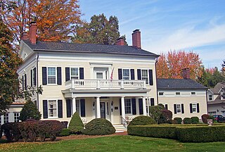
Cold Spring is a village in the town of Philipstown in Putnam County, New York, United States. The population was 1,986 at the 2020 census. It borders the smaller village of Nelsonville and the hamlets of Garrison and North Highlands. The central area of the village is on the National Register of Historic Places as the Cold Spring Historic District due to its many well-preserved 19th-century buildings, constructed to accommodate workers at the nearby West Point Foundry. The town is the birthplace of General Gouverneur K. Warren, who was an important figure in the Union Army during the Civil War. The village, located in the Hudson Highlands, sits at the deepest point of the Hudson River, directly across from West Point. Cold Spring serves as a weekend getaway for many residents of New York City.

<span class="mw-page-title-main">Kent, New York</span> Town in New York, United States

Town of Kent is a town in Putnam County, New York, United States. The population was 12,900 at the 2020 census. The name is that of an early settler family. The town is in the north-central part of the Putnam County. Many of the lakes are reservoirs for New York City.

<span class="mw-page-title-main">Mahopac, New York</span> Census-designated place & hamlet in New York, United States

Mahopac is a hamlet in the town of Carmel in Putnam County, New York, United States. Also known as Lake Mahopac, the exurb is located some 47 miles (76 km) north of New York City, on US Route 6 at the county's southern central border with Westchester County. As of the 2020 census, the population was 8,933.

<span class="mw-page-title-main">Nelsonville, New York</span> Village in New York, United States

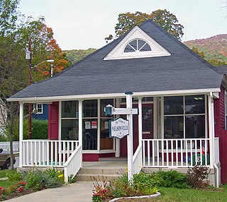
Nelsonville is a village located in the town of Philipstown in Putnam County, New York, United States. The population was 628 at the time of the 2010 census.

<span class="mw-page-title-main">Putnam Valley, New York</span> Town in New York, United States

Putnam Valley is a town in Putnam County, New York, United States. The population was 11,809 at the 2010 census. Its location is northeast of New York City, in the southwestern part of Putnam County. Putnam Valley calls itself the "Town of Lakes".

<span class="mw-page-title-main">Southeast, New York</span> Town in New York, United States

Southeast is a town in Putnam County, New York, United States, so named for its location in the southeastern corner of the county. The population was 18,058 at the 2020 census. The town as a whole is informally referred to as Brewster, the town's principal settlement; the latter is also an incorporated village within the town's borders. Interstate 84, Interstate 684, U.S. Route 202, US Route 6, and NY 22 are the primary routes through the town.

<span class="mw-page-title-main">Cortlandt, New York</span> Town in New York, United States

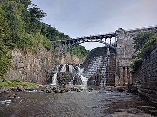
Cortlandt is a town in Westchester County, New York, United States, located at the northwestern edge of the county, at the eastern terminus of the Bear Mountain Bridge. The town includes the villages of Buchanan and Croton-on-Hudson.

<span class="mw-page-title-main">Fishkill (town), New York</span> Town in New York, United States

Fishkill is a town in the southwestern part of Dutchess County, New York, United States. It lies approximately 60 miles (97 km) north of New York City. The population was 24,226 at the 2010 census. Fishkill surrounds the city of Beacon, and contains a village, which is also named Fishkill.

<span class="mw-page-title-main">Hudson Highlands State Park</span> Protected area in mountains along Hudson River north of New York City

Hudson Highlands State Park is a non-contiguous state park in the U.S. state of New York, located on the east side of the Hudson River. The park runs from Peekskill in Westchester County, through Putnam County, to Beacon in Dutchess County, in the eastern section of the Hudson Highlands.

<span class="mw-page-title-main">New York State Route 301</span> State highway in Putnam County, New York, US

New York State Route 301 (NY 301), also known as the Hudson River Turnpike, is an intra-county state highway stretching across three-quarters of Putnam County, New York, in the United States. The western terminus of NY 301 is at an intersection with NY 9D in Cold Spring. Its eastern terminus is at a junction with NY 52 in Carmel. Along the way, NY 301 meets U.S. Route 9 (US 9) and the Taconic State Parkway and passes through Clarence Fahnestock State Park. The section of the route between NY 9D and US 9 is ceremonially designated as the Sergeant Albert Ireland Memorial Highway.

<span class="mw-page-title-main">New York State Route 9D</span> State highway in New York, United States

New York State Route 9D (NY 9D) is a north–south state highway in the Hudson Valley region of New York in the United States. It starts at the eastern end of the Bear Mountain Bridge at an intersection with U.S. Route 6 (US 6) and US 202 in Westchester County, and follows the eastern shore of the Hudson River for 25.21 miles (40.57 km) to a junction with US 9 north of the village of Wappingers Falls in Dutchess County. While US 9 follows a more inland routing between the bridge and Wappingers Falls, the riverside course of NY 9D takes the route through the village of Cold Spring and the city of Beacon.

<span class="mw-page-title-main">Fishkill Creek</span> Tributary of the Hudson River in southern Dutchess County, New York

Fishkill Creek is a tributary of the Hudson River in Dutchess County, New York, United States. At 33.5 miles (53.9 km) it is the second longest stream in the county, after Wappinger Creek. It rises in the town of Union Vale and flows generally southwest to a small estuary on the Hudson just south of Beacon. Part of its 193-square-mile (500 km2) watershed is in Putnam County to the south. Sprout Creek, the county's third-longest creek, is its most significant tributary. Whaley and Sylvan lakes and Beacon Reservoir, its largest, deepest and highest lakes, are among the bodies of water within the watershed.

<span class="mw-page-title-main">Frederick Philipse</span> American colonial merchant (1626–1702)

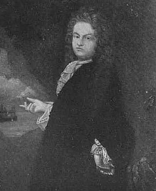
Frederick Philipse, first Lord of the Manor of Philipseborough (Philipsburg) and patriarch of the Philipse family, was a Dutch immigrant to North America of Bohemian heritage. A merchant, he arrived in America as early as 1653. In 1662, he married Margaret Hardenbrook de Vries, a wealthy and driven widow. Together, and variously in league with slavers, pirates, and other undesirables alongside the prominent and respectable, the couple amassed a fortune.

The Hudson Highlands Multiple Resource Area is a Multiple Property Submission study supporting multiple listings in 1982 to the United States National Register of Historic Places. It originally included 58 properties spread over the counties of Dutchess, Putnam, Westchester, Orange and Rockland.

<span class="mw-page-title-main">Philipse Patent</span> British royal patent for land on the Hudson River

The Philipse Patent was a British royal patent for a large tract of land on the east bank of the Hudson River about 50 miles north of New York City. It was purchased in 1697 by Adolphus Philipse, a wealthy landowner of Dutch descent in the Province of New York, and in time became today's Putnam County.

<span class="mw-page-title-main">North Highlands, New York</span> Hamlet in New York, United States

North Highlands is a hamlet in Putnam County, New York which consists of the northernmost portions of Philipstown in the Hudson Highlands. Like the adjacent village of Nelsonville, it shares a ZIP Code and school district with nearby Cold Spring.

References

  1. "2020 U.S. Gazetteer Files". United States Census Bureau. Retrieved March 8, 2024.
  2. 1 2 "Profile of General Population and Housing Characteristics: 2020 Demographic Profile Data (DP-1): Philipstown town, Putnam County, New York". United States Census Bureau . Retrieved March 8, 2024.
  3. Smith, Philip Henry, General History of Putnam County: From 1609 to 1876, inclusive, published by the author, Pawling, NY, 1877, p. 44
  4. French's Gazetteer of the State of New York (1860): “The Philipses Patent… divided among the remaining three [children] Philip… Susannah married to Beverley Robinson, and Mary married to Col. Roger Morris. On February 7, 1754, the patent was divided into 9 lots: 3, each 4 mi. square, bordering upon the Hudson and denominated ‘water lots;’ 3, each 4 mi. wide by 12 long, extending N. and S. across the patent, and denominated ‘long lots;’ 3, each 4 mi. square, upon the E. border denominated ‘back lots.’ Philip, Susannah and Mary Philipse each owned one of each kind of lots.
  5. Boundary changes of Putnam County
  6. "Census of Population and Housing". Census.gov. Retrieved June 4, 2015.
  7. "United States Census Bureau QuickFacts". United States Census Bureau. Retrieved February 26, 2022.
  8. "Profile of General Population and Housing Characteristics: 2010 Demographic Profile Data (DP-1): Philipstown town, Putnam County, New York". United States Census Bureau . Retrieved June 14, 2012.
  9. "Town Board". Town of Philipstown. Retrieved February 26, 2022.