Nassau County is an affluent inner suburban county located on Long Island, immediately to the east of New York City. As of the 2020 United States census, Nassau County's population was 1,395,774, making it the sixth-most populous county in the State of New York, and reflecting an increase of 56,242 (+4.2%) from the 1,339,532 residents enumerated at the 2010 census. Its county seat is Mineola, while the county's largest town is Hempstead.

North Hempstead is one of three towns in Nassau County, on Long Island, in New York, United States. The population was 237,639 at the 2020 census.
Lower New York Bay is a section of New York Bay south of the Narrows. The eastern end of the Bay is marked by two spits of land, Sandy Hook, New Jersey, and Rockaway, Queens. The waterway between the spits connects the Bay to the Atlantic Ocean at the New York Bight. Traversing the floor of the Bay southeasterly from the Narrows to the Bight and beyond is Hudson Canyon.

Douglaston–Little Neck is a neighborhood in the northeastern part of the New York City borough of Queens. The community is located on the North Shore of Long Island, bordered to the east by the region of Great Neck in Nassau County, to the south by Glen Oaks and the North Shore Towers, and to the west by Bayside.

The Cross Island Parkway is a parkway in New York City, part of the Belt System of parkways running along the perimeter of the boroughs of Queens and Brooklyn. The Cross Island Parkway runs 10.6 miles (17.1 km) from the Whitestone Expressway in Whitestone past the Throgs Neck Bridge, along and across the border of Queens and Nassau County to meet up with the Southern State Parkway, acting as a sort of separation point which designates the limits of New York City. The road is designated as New York State Route 907A (NY 907A), an unsigned reference route, and bears the honorary name 100th Infantry Division Parkway.
Bayside is a neighborhood located in the New York City borough of Queens. It is bounded by Whitestone to the northwest, the Long Island Sound and Little Neck Bay to the northeast, Douglaston to the east, Oakland Gardens to the south, and Fresh Meadows to the west. CNN Money ranked Bayside as one of the most expensive housing markets nationally when analyzing comparable detached homes throughout the United States. Despite its large housing stock of free-standing homes, it nationally ranks high to very high in population density.

The North Shore of Long Island is the area along the northern coast of New York's Long Island bordering Long Island Sound. Known for its extreme wealth and lavish estates, the North Shore exploded into affluence at the turn of the 20th century, earning it the nickname the Gold Coast. Historically, this term refers to the affluent coastline neighborhoods of the towns of North Hempstead and Oyster Bay in Nassau County and Huntington in Suffolk County. Some definitions may also include the parts of Smithtown that face the Sound. The region is also largely coextensive with the Gold Coast region of Long Island, though this region excludes Smithtown, as the easternmost Gold Coast mansion is the Geissler Estate, located just west of Indian Hills Country Club in the Fort Salonga section of Huntington.

New York State Route 25A (NY 25A) is a state highway on Long Island in New York, United States. It serves as the main east–west route for most of the North Shore of Long Island, running for 73 miles (117 km) from Interstate 495 (I-495) at the Queens–Midtown Tunnel in the New York City borough of Queens to NY 25 in Calverton, Suffolk County. The highway is a northern alternate route of NY 25, which follows a more inland routing along Jericho Turnpike.
Bloodgood Haviland Cutter (1817–1906), popularly known as the "Long Island Farmer Poet," was a prominent and colorful figure in late 19th century Long Island, New York.

The hard clam, also known as the round clam, hard-shellclam, or the quahog, is an edible marine bivalve mollusk that is native to the eastern shores of North America and Central America from Prince Edward Island to the Yucatán Peninsula. It is one of many unrelated edible bivalves that in the United States are frequently referred to simply as clams. Older literature sources may use the systematic name Venus mercenaria; this species is in the family Veneridae, the venus clams.
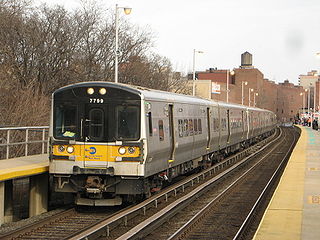
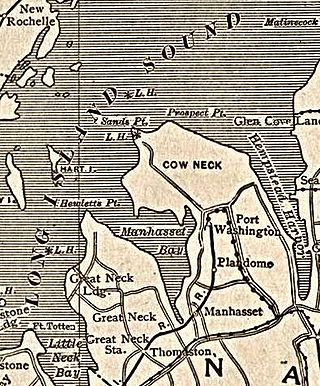
The Port Washington Branch is an electrified two-track rail line and service owned and operated by the Long Island Rail Road in the U.S. state of New York. It branches north from the Main Line at the former Winfield Junction station, just east of the Woodside station in the New York City borough of Queens, and runs roughly parallel to Northern Boulevard past Mets-Willets Point, Flushing, Murray Hill, Broadway, Auburndale, Bayside, Douglaston, Little Neck, and then crosses into Nassau County for stops in Great Neck, Manhasset, and Plandome before terminating at Port Washington.
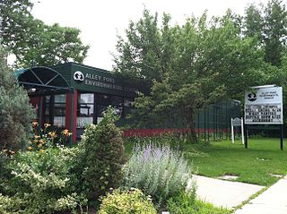
Alley Pond Park is the second-largest public park in Queens, New York City, occupying 655.3 acres (265.2 ha). The park is bordered to the east by Douglaston, to the west by Bayside, to the north by Little Neck Bay, and to the south by Union Turnpike. The Cross Island Parkway travels north-south through the park, while the Long Island Expressway and Grand Central Parkway travel east-west through the park. The park primarily consists of woodlands south of the Long Island Expressway and meadowlands north of the expressway. It is run and operated by the New York City Department of Parks and Recreation.
The North Shore Bus Company operated public buses in Queens, New York City. It was established in 1920 as the successor to the New York and North Shore Traction Company trolley system, and operated until 1947 when it went bankrupt, and its operations were taken over by the New York City Board of Transportation.
The Brooklyn–Queens Greenway is a bicycling and pedestrian path connecting parks and roads in the New York City boroughs of Brooklyn and Queens, connecting Coney Island in the south to Fort Totten in the north, on Long Island Sound. The route connects major sites in the two boroughs, such as the New York Aquarium, Brooklyn Museum, the Brooklyn Botanic Garden, the New York Hall of Science and Citi Field.

Cape Muzon is a cape located in the Alexander Archipelago of the U.S. state of Alaska. It is the southernmost point of Dall Island and the headland marking the northwestern extremity of the Dixon Entrance. The boundary line separating Alaska from Canada runs very close to Cape Muzon, although according to the Alaska Boundary Treaty Cape Muzon is defined precisely as the western end of the so-called A-B Line, part of the Canada–United States border.
Udalls Cove is a marshland and wetland area located in Queens, New York City, off Little Neck Bay between Douglaston and Little Neck Bay. It is one of the few remaining salt marshes on the North Shore in the Metropolitan area; another being the salt marsh southwest of the cove, at Alley Pond Park. For many years, activists and locals have struggled to ensure that these marshlands and wetlands were properly preserved in their natural state by preventing development in the region. These marshlands/wetlands are home to bird and animal life such as muskrats, egrets, and herons, as well as marine life and plants. One of the key agitators to preserve Udall's Cove and its plant and animal Life was Aurora Gareiss, founder of the Udalls Cove Preservation Committee.

Ikatan Peninsula is the southeastern extremity of Unimak Island in the U.S. state of Alaska.

The Fox Islands Passes are waterways in the Fox Islands area of the U.S. state of Alaska, connecting the Bering Sea with the North Pacific Ocean.