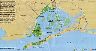
Jamaica Bay is an estuary on the southern portion of the western tip of Long Island, in the U.S. state of New York. The estuary is partially man-made, and partially natural. The bay connects with Lower New York Bay to the west, through Rockaway Inlet, and is the westernmost of the coastal lagoons on the south shore of Long Island. Politically, it is primarily divided between the boroughs of Brooklyn and Queens in New York City, with a small part touching Nassau County.

The Great South Bay is a lagoon situated between Long Island and Fire Island, in the State of New York. It is about 45 miles (72 km) long and has an average depth of 4 feet 3 inches (1.3 m) and is 20 feet (6.1 m) at its deepest. It is protected from the Atlantic Ocean by Fire Island, a barrier island, as well as the eastern end of Jones Beach Island and Captree Island.

The New York–New Jersey Harbor Estuary, also known as the Hudson-Raritan Estuary, is in the northeastern states of New Jersey and New York on the East Coast of the United States. The system of waterways of the Port of New York and New Jersey forms one of the most intricate natural harbors in the world and one of the busiest ports of the United States. The harbor opens onto the New York Bight in the Atlantic Ocean to the southeast and Long Island Sound to the northeast.
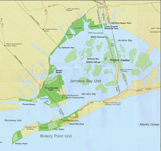
Rockaway Inlet is a strait connecting Jamaica Bay, wholly within New York City, with the Atlantic Ocean. It separates the Rockaway Peninsula in Queens from the Floyd Bennett Field in Brooklyn.
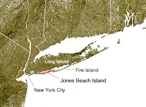
Jones Beach Island is one of the outer barrier islands off the southern coast of Long Island in the U.S. state of New York.

Broad Channel is a neighborhood in the southern portion of the New York City borough of Queens. It occupies the southern portion of Rulers Bar Hassock, the only inhabited island in Jamaica Bay.
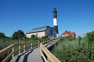
Fire Island National Seashore (FINS) is a United States National Seashore that protects a 26-mile (42 km) section of Fire Island, an approximately 30-mile (48 km) long and 0.5-mile (0.80 km) wide barrier island separated from Long Island by the Great South Bay. The island is part of New York State's Suffolk County and the Outer Barrier.

New York State Route 878 (NY 878) is an expressway on Long Island and in New York City. The route exists in two sections, which both form the Nassau Expressway. NY 878's western terminus is the Belt Parkway and Conduit Avenue (NY 27) in Ozone Park, within southern Queens. Its southern terminus is immediately before the Village of Atlantic Beach, at the Atlantic Beach Bridge in Lawrence, within southwestern Nassau County. NY 878 is discontinuous between Farmers Boulevard in Queens and the town of Inwood in Nassau County. The two sections are connected to each other by Rockaway Boulevard and Rockaway Turnpike.

The Far Rockaway Branch is an electrified rail line and service owned and operated by the Long Island Rail Road in the U.S. state of New York. The branch begins at Valley Interlocking, just east of Valley Stream station. From Valley Stream, the line heads south and southwest through southwestern Nassau County, ending at Far Rockaway in Queens, thus reentering New York City. LIRR maps and schedules indicate that the Far Rockaway Branch service continues west along the Atlantic Branch to Jamaica. This two-track branch provides all day service in both directions to Grand Central Madison and Penn Station, both in Midtown Manhattan.

Hog Island was the name of two islands near Long Island, New York until the 1890s. One is the present day Barnum Island, which includes the villages of Island Park and Harbor Isle in Nassau County. The other was a mile-long (1600 m) barrier island that existed to the south of Rockaway Beach in Queens before being mostly destroyed by the 1893 New York hurricane and completely lost to erosion and storm damage by 1902.
Shinnecock Inlet is the easternmost of five major inlets connecting bays to the Atlantic Ocean through the narrow 100-mile-long (160 km) Outer Barrier that stretches from New York City to Southampton, New York on the south shore of Long Island. It splits Westhampton Island from the peninsula extending from Southampton Village. The inlet was formed by the 1938 New England hurricane, which killed several people when it permanently broke through the island in Hampton Bays, New York. The name comes from the Shinnecock Indian Nation.

The Outer Barrier, also known as the Long Island and New York City barrier islands, refers to the string of barrier islands that divide the lagoons south of Long Island, New York from the Atlantic Ocean. These islands include Long Beach Barrier Island, Barnum Island, Jones Beach Island, Fire Island and Westhampton Island. The outer barrier extends 75 miles (121 km) along the South Shore of Long Island, from the Rockaway Peninsula in New York City to the east end of Shinnecock Bay in Suffolk County.
The IND Rockaway Line is a rapid transit line of the IND Division of the New York City Subway, operating in Queens. It branches from the IND Fulton Street Line at Rockaway Boulevard, extending over the Jamaica Bay, into the Rockaways. At its southern end in the Rockaways, the line has two branches: one traveling east to Far Rockaway–Mott Avenue and one traveling west to Rockaway Park–Beach 116th Street. The A train serves the line on the Far Rockaway branch, as well as on the section north of Hammels Wye. The Rockaway Park Shuttle runs between Broad Channel and Rockaway Park. Five rush hour A trains provide service between Rockaway Park and Manhattan in the peak direction.

Jacob Riis Park, also called Jacob A. Riis Park and Riis Park, is a seaside park on the southwestern portion of the Rockaway Peninsula in the New York City borough of Queens. It lies at the foot of the Marine Parkway–Gil Hodges Memorial Bridge, east of Fort Tilden, and west of Neponsit and Rockaway Beach. Originally run by the New York City Department of Parks and Recreation, it later became part of the Jamaica Bay Unit of the Gateway National Recreation Area, and is managed by the National Park Service (NPS). It features an extensive sand beach along the Atlantic Ocean coastline and several historic Art Deco structures.

Hammels is an area within Rockaway Beach on the Rockaway Peninsula in the New York City borough of Queens. It is located west of Arverne and east of Seaside, and is centered on Beach 84th Street. Its main thoroughfare is Beach Channel Drive. The New York City Subway's A train travels through the neighborhood on the IND Rockaway Line. The Hammel Houses, a public housing project built in 1955, is located in the neighborhood.

Reynolds Channel is a strait in Nassau County, New York that separates Long Beach Barrier Island, which contains the City of Long Beach and the villages of Atlantic Beach, Lido Beach, and Point Lookout, from Long Island, Barnum Island, Harbor Isle, and various uninhabited islands between Long Beach Island and Long Island. The channel begins at the East Rockaway Inlet to the west, and ends at Point Lookout to the east, where it merges with the Jones Inlet.

Moriches Inlet is an inlet connecting Moriches Bay and the Atlantic Ocean, in Suffolk County, New York. The name Moriches comes from Meritces – a Native American who owned land on Moriches Neck.

Fire Island Inlet is an inlet on the south shore of Long Island, New York.

The State Boat Channel Bridge is a bascule bridge (drawbridge) in Suffolk County, New York, United States. It crosses over the Long Island New York State Boat Channel connecting Captree Island and Jones Beach Island on Robert Moses Causeway in the Oak Beach–Captree area within the town of Babylon.

Jones Inlet is located at the westernmost end of the 17-mile (27 km) long Jones Beach barrier island that runs along Long Island's south shore. The inlet separates Jones Beach State Park's West End from the community of Point Lookout and connects South Oyster Bay with the Atlantic Ocean. In 2006, the inlet handled approximately 10,000 tons of commercial tonnage.


