Delaware Valley

Last updated

Delaware Valley
Greater Philadelphia
Philadelphia metropolitan area
Philadelphia-Camden-Wilmington, PA-NJ-DE-MD CSA
Philadelphia from South Street Bridge July 2016 panorama 3.jpg
Center City Philadelphia (in background) and the Schuylkill River (on left) as seen from South Street Bridge in July 2016
Delaware Valley
Philadelphia–Reading–Camden, PA–NJ–DE–MD CSA
Country Flag of United States.svg United States
States Flag of Pennsylvania.svg Pennsylvania
Flag of New Jersey.svg New Jersey
Flag of Delaware.svg Delaware
Flag of Maryland.svg Maryland
Principal city Philadelphia
Satellite cities and towns Camden
Wilmington
Atlantic City
Reading
Trenton [lower-alpha 1]
Vineland
Conshohocken
Dover
Chester
Upper Darby
Media
Middletown Township
Hammonton
Pennsauken Township
Norristown
Doylestown
Cherry Hill
West Chester
Evesham
Washington Township
Millville
Salem
Cape May Court House
Lower Township
The Wildwoods
Brigantine
Ventnor City
Margate City
Ocean City
Sea Isle City
Haverford
Bridgeton
Coatesville
Lower Merion
Gloucester Township
Downingtown
Phoenixville
New Castle
Pottstown
King of Prussia
Bensalem Township
Burlington City and Burlington Township
Middle Township (Cape May County)
Mount Holly
Newark
Hamilton Township (Mays Landing)
Woodbury
Elkton
Cheltenham Township
Abington Township
Bristol Township
Mount Laurel
Northampton Township
Winslow Township
New Hope
Falls Township
Middletown Township (Bucks County)
Egg Harbor Township
Galloway Township
Pennsville
Maurice River Township
Area
  Urban
1,981.4 sq mi (5,131.7 km2)
  Metro
5,118 sq mi (13,256 km2)
Elevation0 - 1,080 ft (0 - 329 m)
Population
 (2021 est.)
   Urban
5,441,567 (5th)
  Metro density1,217.00/sq mi (469.89/km2)
   MSA
6,228,601 (7th)
   CSA
7,366,346 (9th)
 MSA/CSA = 2021, Urban = 2010
GDP
[3]
  MSA$518.5 billion (2022)
Time zone UTC−5 (EST)
  Summer (DST) UTC−4 (EST)
Area codes 215/267/445, 302, 410/443/667, 609/640, 610/484/835, 717/223, 856

The Delaware Valley, sometimes referred to as Greater Philadelphia or the Philadelphia metropolitan area, is a metropolitan region in the Northeast United States that centers around Philadelphia, the nation's sixth-most populous city, and spans parts of four U.S. states: southeastern Pennsylvania, southern New Jersey, northern Delaware, and the northern Eastern Shore of Maryland. With a core metropolitan statistical area population of 6.288 million residents and a combined statistical area population of 7.366 million as of the 2020 census, the Delaware Valley is the eighth-largest metropolitan region in the nation and North America, and the 68th-largest metropolitan region in the world.

Contents

In addition to Philadelphia, other major urban population centers in the Delaware Valley include Reading, Upper Darby Township, and Chester in Pennsylvania; Atlantic City, Camden, Vineland, and Cherry Hill in South Jersey; and Wilmington and Dover in Delaware. The Philadelphia metropolitan area's gross domestic product (GDP) exceeds $518 billion, making it the tenth-largest metropolitan economy in the nation as of 2022.

The Delaware Valley has been influential in the nation's history and economy. The area has been home to many people and sites significant to American culture, history, and politics. Philadelphia is sometimes known as "The Birthplace of America", [4] since it served as the revolutionary capital during the colonial era, where the Second Continental Congress gathered at Independence Hall to unanimously adopt the Declaration of Independence, authorize the formation of the Continental Army, and appoint George Washington its commander to resist the British. Following the Continental Army's victory, Philadelphia served as the nation's first capital for most of the 18th century until 1800, when construction of Washington, D.C. was completed. In 1789, the U.S. Constitution, the longest-standing body of federal law, was ratified at Independence Hall in Philadelphia in 1789.

The Delaware Valley is one of the nation's leading regions for academia and academic research with a considerable number of globally-known and highly ranked universities, including the University of Pennsylvania, one of eight Ivy League universities in the nation. Other universities and colleges and Philadelphia include Drexel University, Thomas Jefferson University, Rowan University, Villanova University, Saint Joseph's University, Temple University, Rutgers University–Camden, La Salle University, the University of Delaware, Stockton University, and others. [5] Philadelphia and the Delaware Valley are a biotechnology hub. [6] As of 2023, metropolitan Philadelphia had entered the ranks of the top five U.S. venture capital centers, facilitated by its relative proximity to the New York metropolitan area and its entrepreneurial and financial ecosystems. [7] Elsewhere in the Delaware Valley, South Jersey has emerged as an East Coast epicenter for logistics and major warehouses. [8]

Geography

The drainage basin of the Delaware River Delaware river basin map.png
The drainage basin of the Delaware River
A warehouse in South Jersey Warehouse in New Jersey where trucks deliver granite slabs.jpg
A warehouse in South Jersey

The Delaware Valley is geographically associated and proximate to the Delaware River and its three primary tributaries, the Schuylkill River, Lehigh River, and Brandywine Creek.

U.S. government agencies have reached various definitions of the Delaware Valley and metropolitan Philadelphia. The Office of Management and Budget (OMB) defines metropolitan statistical area (MSAs), which are regions with relatively high population densities at their cores and close economic ties throughout their respective areas. MSAs are further combined into combined statistical areas (CSAs), reflecting commuting patterns. Neither is a formal administrative division.

Metropolitan statistical area (MSA)

Historical population
CensusPop.Note
1820 171,430
1830 228,20333.1%
1840 305,27833.8%
1850 467,05353.0%
1860 636,02936.2%
1870 841,23032.3%
1880 1,062,67726.3%
1890 1,391,15730.9%
1900 1,892,49636.0%
1910 2,268,20919.9%
1920 2,714,27119.7%
1930 3,137,04015.6%
1940 3,299,6375.2%
1950 3,671,04811.3%
1960 4,757,46229.6%
1970 5,317,40711.8%
1980 5,240,039−1.5%
1990 5,435,4683.7%
2000 5,687,1474.6%
2010 5,965,3434.9%
2020 6,245,0514.7%
2022 (est.)6,241,164−0.1%
U.S. Decennial Census

Philadelphia is located in the Philadelphia-Camden-Wilmington Metropolitan Statistical Area, which includes:

Combined statistical area (CSA)

Philadelphia-Reading-Camden Combined Statistical Area includes:

Delaware Regional Planning Commission

The Delaware Valley Regional Planning Commission (DVRPC) serves all of the counties of the Delaware Valley MSA except for the counties in the Wilmington, DE-MD-NJ Metropolitan Division. However, in addition to the Delaware Valley, DVRPC's jurisdiction includes Mercer County, New Jersey, which OMB classifies as the Trenton-Princeton, NJ MSA and part of the larger New York-Newark CSA. [9]

Population

The Delaware Valley is part of the Northeast megalopolis, the second-most highly populated megaregion of the U.S. with 52.3 million residents. Boswash.png
The Delaware Valley is part of the Northeast megalopolis, the second-most highly populated megaregion of the U.S. with 52.3 million residents.

As of the 2020 U.S. census, the Philadelphia-Camden-Wilmington Metropolitan Statistical Area is the seventh-largest MSA in the nation with 6,245,051 people. [10] As of 2020, the Philadelphia–Reading–Camden, PA-NJ-DE-MD CSA is the nation's ninth-largest combined statistical area with a population of 7,379,700,

The Philadelphia-Camden-Wilmington Metropolitan Statistical Area's population of slightly over six million people exceeds the populations of whole nations, including those of Lebanon, Denmark, and Nicaragua.

Economy

As of 2021, the Philadelphia-Camden-Wilmington Metropolitan Statistical Area has a gross domestic product of $477.58 billion, the tenth-largest among the nation's MSAs. The MSA's nominal gross domestic product of $431 billion is comparable to countries, such as Belgium, Iran, and Thailand. [11] Metropolitan Philadelphia is one of the top five American venture capital hubs, credited to its proximity to the New York metropolitan area and its financial and tech and biotechnology ecosystems.

At least two educational institutions, Delaware Valley Regional High School in Alexandria Township, New Jersey, and Delaware Valley College in Doylestown Township, Pennsylvania, and a now defunct local newspaper, The Delaware Valley News in Frenchtown, New Jersey, are named for the region.

Subregions

The Philadelphia-Reading-Camden combined statistical area includes sixteen counties in four states. The five Pennsylvania counties in the metropolitan statistical area are collectively known as Southeastern Pennsylvania. [12] In addition to Philadelphia, major municipalities in Southeastern Pennsylvania include the inner suburbs of Upper Darby Township and Bensalem Township. Berks County, which forms its own MSA and contains the CSA's second largest city, Reading, is occasionally not considered to be part of Southeastern Pennsylvania and is sometimes assigned to South Central Pennsylvania.

The seven New Jersey counties in the CSA are each located in South Jersey, [13] and include: Atlantic County, Cape May County, and Cumberland County each form their own respective metropolitan statistical areas. Atlantic City, Cape May County, New Jersey, and the southern Jersey Shore, including Margate City, Ventnor City, the Wildwoods, and Sea Isle City, are major tourist destinations for people from inside and outside of the Delaware Valley. Other major municipalities in South Jersey include Cherry Hill and Camden, which is across the Delaware River, east of Philadelphia.

The two counties of Delaware in the CSA constitute a majority of Delaware's land mass and population. Wilmington is the most populous city in Delaware and the fifth-most populous municipality in the Delaware Valley. The lone Maryland county in the Philadelphia-Reading-Camden Combined Statistical Area is part of the region known as the Eastern Shore of Maryland.

Media market

The Delaware Valley and several areas bordering up on it, including the Lehigh Valley, are part of the Philadelphia media market, the fourth-largest media market in the nation as of 2023. [14]

Components of Philadelphia-Camden-Wilmington, PA-NJ-DE-MD Metropolitan Statistical Area

County 2021 Estimate2020 CensusChangeAreaDensity
Philadelphia County 1,576,2511,603,797−1.72%134.28 sq mi (347.8 km2)
Montgomery County 860,578856,553+0.47%483 sq mi (1,250 km2)
Bucks County 646,098646,538−0.07%604 sq mi (1,560 km2)
Delaware County 573,849576,830−0.52%184 sq mi (480 km2)
New Castle County 571,708570,719+0.17%426 sq mi (1,100 km2)
Chester County 538,649534,413+0.79%751 sq mi (1,950 km2)
Camden County 523,771523,485+0.05%221.26 sq mi (573.1 km2)
Burlington County 464,269461,860+0.52%798.58 sq mi (2,068.3 km2)
Gloucester County 304,477302,294+0.72%322 sq mi (830 km2)
Salem County 65,04664,837+0.32%331.9 sq mi (860 km2)
Cecil County 103,725104,870−1.09%418 sq mi (1,080 km2)
Total MSA Population6,228,6016,245,051−0.26%4,602.02 sq mi (11,919.2 km2)

Additional Components of Philadelphia-Camden-Vineland, PA-NJ-DE-MD Combined Statistical Area

County 2021 Estimate2020 CensusChangeAreaDensity
Berks County 429,342428,849+0.11%857 sq mi (2,220 km2)
Atlantic County 274,966274,534+0.16%555.7 sq mi (1,439 km2)
Kent County 184,149181,851+1.26%586 sq mi (1,520 km2)
Cumberland County 153,627154,152−0.34%483.7 sq mi (1,253 km2)
Cape May County 95,66195,263+0.42%251.42 sq mi (651.2 km2)
Total CSA Population7,366,3467,379,700−0.18%7,335.84 sq mi (18,999.7 km2)

Largest municipalities

Philadelphia, the most populous city in the Delaware Valley and sixth-most populous city in the nation with over 1.6 million residents Philadelphia skyline from South Street Bridge January 2020 (rotate 2 degrees perspective correction crop 4-1).jpg
Philadelphia, the most populous city in the Delaware Valley and sixth-most populous city in the nation with over 1.6 million residents
Reading, Pennsylvania Reading, Pennsylvani skyline.jpg
Reading, Pennsylvania
Ocean City, New Jersey Ocean City NJ beach looking north at 12th Street.jpeg
Ocean City, New Jersey
Wilmington, Delaware Wilmington Delaware skyline.jpg
Wilmington, Delaware

The following municipalities are all within the Philadelphia-Reading-Camden combined statistical area and part of the Delaware Valley:

CityPop. [15] CountyState
Philadelphia 1,567,872PhiladelphiaPA
Reading 87,575BerksPA
Upper Darby Township 82,765DelawarePA
Camden 74,420CamdenNJ
Wilmington 71,502New CastleDE
Cherry Hill 70,976CamdenNJ
Gloucester Township 64,049CamdenNJ
Vineland 60,876CumberlandNJ
Bensalem Township 60,354BucksPA
Lower Merion Township 58,220MontgomeryPA
Abington Township 55,640MontgomeryPA
Bristol Township 54,170BucksPA
Haverford Township 48,893DelawarePA
Washington Township 48,301GloucesterNJ
Evesham Township 45,578BurlingtonNJ
Middletown Township 45,318BucksPA
Egg Harbor Township 43,747AtlanticNJ
Mount Laurel 41,849BurlingtonNJ
Northampton Township 39,562BucksPA
Winslow Township 39,417CamdenNJ

Statistical history

When metropolitan areas were originally defined in 1950, most of the area now in the Delaware Valley was split between four metropolitan areas, or standard metropolitan areas, as they were then called. The Philadelphia SMA included Philadelphia, Bucks, Chester, Delaware, and Montgomery counties in Pennsylvania, and Burlington, Camden, and Gloucester counties in South Jersey. The Wilmington SMA included New Castle County in Delaware and Salem County in South Jersey. Berks County was designated as the Reading SMA and Atlantic County, New Jersey was the Atlantic City SMA.

In 1960, Cecil County, Maryland was added to what was now the Wilmington Standard Metropolitan Statistical Area (SMSA). In 1980, Cumberland County, New Jersey was defined as the Vineland-Millville-Bridgeton SMSA.

In 1990, the Philadelphia, Wilmington and Vineland-Millville-Bridgeton SMSAs were merged with the Trenton SMSA to form the Philadelphia-Wilmington-Trenton Consolidated Metropolitan Statistical Area. At the same time, Cape May County, New Jersey was added to the Atlantic City SMSA. The "Philadelphia-Wilmington-Trenton" became obsolete one census later when Trenton, New Jersey was moved to the New York-Newark-Bridgeport CSA. The Philadelphia-Wilmington-Vineland CSA included the Philadelphia-Wilmington-Camden MSA and the Vineland-Millville-Bridgeton MSA. [16]

In 2000, Kent County, Delaware was designated the Dover MSA, and Kent County and Atlantic City were added to the Philadelphia CSA in 2010. As a result of new 2010 definitions, based on a threshold of 15% labor interchange between MSAs, two additional MSAs were added, Ocean City, New Jersey and Reading, Pennsylvania. The CSA to which they belong is known as Philadelphia-Reading-Camden. [17]

Characteristics

Grave of some of the 57 Irish victims of Duffy's Cut in West Laurel Hill Cemetery in Bala Cynwyd; Irish Americans make up the largest ethnicity in the Delaware Valley. Duffys Cut Cross West Laurel Hill.JPG
Grave of some of the 57 Irish victims of Duffy's Cut in West Laurel Hill Cemetery in Bala Cynwyd; Irish Americans make up the largest ethnicity in the Delaware Valley.
Philadelphia's Chinatown, home to many Chinese and Vietnamese restaurants Friendship Gate Chinatown Philadelphia from east.jpg
Philadelphia's Chinatown, home to many Chinese and Vietnamese restaurants
Hindu Temple of Delaware in Hockessin, Delaware Hindu Temple Delaware Pic -2.jpg
Hindu Temple of Delaware in Hockessin, Delaware
West Chester, Pennsylvania Westchester.jpg
West Chester, Pennsylvania

Philadelphia's suburbs contain a high concentration of malls, the two largest of which have at least 5,000,000 square feet (460,000 m2) of office space, and at least 600,000 square feet (56,000 m2) of retail. These are the King of Prussia mall in King of Prussia, Pennsylvania, which is the largest in the U.S. (leasable sq. feet of retail space), and the Cherry Hill Mall in Cherry Hill, New Jersey, which was the first enclosed mall on the East Coast. In addition, the Christiana Mall in Newark, Delaware, is a popular destination due to its proximity to Interstate 95 and because of the availability of tax-free shopping in Delaware. Malls, office complexes, strip shopping plazas, expressways, and tract housing are common sights, and more and more continue to replace rolling countryside, farms, woods, and wetlands. However, due to strong opposition by residents and political officials, many acres of land have been preserved throughout the Delaware Valley. Older townships and large boroughs, such as Cheltenham, Norristown, Jenkintown, Upper Darby, and West Chester retain distinct community identities while engulfed in suburbia. The fastest-growing counties[ as of? ] are Chester, Montgomery, Bucks, and Gloucester.

Mid-Atlantic American English and its subset, Philadelphia English, are two common dialects of American English in Philadelphia and the Delaware Valley.

Climate

The Delaware Valley has four distinct seasons with ample precipitation and is divided by the 0 °C (32 °F) January isotherm. Philadelphia and the New Jersey portion of the area, almost all of the Delaware and Maryland portions, most of Delaware County and lower Bucks County, lowland southern Chester County, and some southern and lowland areas of Montgomery County have a humid subtropical climate (Cfa according to the Köppen climate classification.) The remainder of the Delaware Valley has a hot-summer humid continental climate (Dfa.) PRISM Climate Group at Oregon State University

Snow amounts may vary widely year-to-year and normally do vary widely within the Delaware Valley. The region has two ski resorts, Bear Creek Mountain Resort in Longswamp Township, Berks County and Spring Mountain Adventures in central Montgomery County.

Using the -3 °C January isotherm as a boundary, all of the Delaware Valley is humid subtropical. The hardiness zone in the region ranges from 6b in higher areas of Berks and northern Bucks Counties to 8a in Atlantic City and Cape May.

Using the Trewartha climate classification system, which requires eight months to average at least 50 °F for the climate to be considered subtropical, the region only has seven such months, so the area considered Cfa by Köppen is oceanic (Do) in the Trewartha system.

MonthJanFebMarAprMayJunJulAugSepOctNovDecYear
Record high °F (°C)74
(23)
79
(26)
87
(31)
95
(35)
97
(36)
102
(39)
104
(40)
106
(41)
102
(39)
96
(36)
84
(29)
73
(23)
106
(41)
Mean maximum °F (°C)63.3
(17.4)
63.5
(17.5)
73.8
(23.2)
84.3
(29.1)
90.2
(32.3)
94.8
(34.9)
97.1
(36.2)
94.8
(34.9)
90.6
(32.6)
82.6
(28.1)
72.4
(22.4)
64.2
(17.9)
98.1
(36.7)
Mean daily maximum °F (°C)41.3
(5.2)
44.3
(6.8)
52.8
(11.6)
64.7
(18.2)
74.4
(23.6)
83.2
(28.4)
87.8
(31.0)
85.8
(29.9)
78.9
(26.1)
67.2
(19.6)
55.9
(13.3)
46.0
(7.8)
65.2
(18.4)
Daily mean °F (°C)33.7
(0.9)
35.9
(2.2)
43.6
(6.4)
54.5
(12.5)
64.3
(17.9)
73.5
(23.1)
78.7
(25.9)
76.8
(24.9)
69.9
(21.1)
58.2
(14.6)
47.4
(8.6)
38.6
(3.7)
56.3
(13.5)
Mean daily minimum °F (°C)26.0
(−3.3)
27.5
(−2.5)
34.3
(1.3)
44.3
(6.8)
54.2
(12.3)
63.9
(17.7)
69.6
(20.9)
67.9
(19.9)
60.9
(16.1)
49.2
(9.6)
38.8
(3.8)
31.2
(−0.4)
47.3
(8.5)
Mean minimum °F (°C)10.7
(−11.8)
13.7
(−10.2)
20.8
(−6.2)
33.0
(0.6)
43.1
(6.2)
53.2
(11.8)
62.2
(16.8)
60.3
(15.7)
49.5
(9.7)
37.1
(2.8)
26.4
(−3.1)
19.0
(−7.2)
8.6
(−13.0)
Record low °F (°C)−7
(−22)
−11
(−24)
5
(−15)
14
(−10)
28
(−2)
44
(7)
51
(11)
44
(7)
35
(2)
25
(−4)
8
(−13)
−5
(−21)
−11
(−24)
Average precipitation inches (mm)3.13
(80)
2.75
(70)
3.96
(101)
3.47
(88)
3.34
(85)
4.04
(103)
4.38
(111)
4.29
(109)
4.40
(112)
3.47
(88)
2.91
(74)
3.97
(101)
44.11
(1,120)
Average snowfall inches (cm)7.1
(18)
8.4
(21)
3.6
(9.1)
0.3
(0.76)
0.0
(0.0)
0.0
(0.0)
0.0
(0.0)
0.0
(0.0)
0.0
(0.0)
0.0
(0.0)
0.2
(0.51)
3.5
(8.9)
23.1
(59)
Average precipitation days (≥ 0.01 in)11.09.710.910.911.010.310.18.99.39.18.611.0120.8
Average snowy days (≥ 0.1 in)4.13.82.00.20.00.00.00.00.00.00.11.812.0
Average relative humidity (%)66.263.661.760.465.467.869.670.471.670.868.467.767.0
Average dew point °F (°C)19.8
(−6.8)
21.0
(−6.1)
28.6
(−1.9)
37.0
(2.8)
49.5
(9.7)
59.2
(15.1)
64.6
(18.1)
63.7
(17.6)
57.2
(14.0)
45.7
(7.6)
35.6
(2.0)
25.5
(−3.6)
42.3
(5.7)
Mean monthly sunshine hours 155.7154.7202.8217.0245.1271.2275.6260.1219.3204.5154.7137.72,498.4
Percent possible sunshine 52525555556161615959524756
Average ultraviolet index 2346899864225
Source 1: NOAA (relative humidity, dew point and sun 1961–1990) [22] [23] [20]
Source 2: Weather Atlas (UV index) [24]
Climate data for Philadelphia
MonthJanFebMarAprMayJunJulAugSepOctNovDecYear
Average sea temperature °F (°C)41.8
(5.5)
39.9
(4.4)
41.2
(5.1)
46.7
(8.2)
53.9
(12.2)
66.3
(19.0)
74.0
(23.3)
75.9
(24.4)
71.4
(21.9)
64.2
(17.9)
55.1
(12.8)
47.7
(8.8)
56.5
(13.6)
Mean daily daylight hours10.011.012.013.014.015.015.014.012.011.010.09.012.2
Source: Weather Atlas [24]
Climate data for Atlantic City, New Jersey (downtown), 1991–2020 normals, [lower-alpha 4] extremes 1874–present [lower-alpha 5]
MonthJanFebMarAprMayJunJulAugSepOctNovDecYear
Record high °F (°C)72
(22)
77
(25)
86
(30)
91
(33)
95
(35)
99
(37)
102
(39)
104
(40)
94
(34)
91
(33)
80
(27)
74
(23)
104
(40)
Mean maximum °F (°C)63.5
(17.5)
64.8
(18.2)
73.2
(22.9)
83.2
(28.4)
89.3
(31.8)
94.5
(34.7)
96.9
(36.1)
94.6
(34.8)
90.1
(32.3)
82.8
(28.2)
72.7
(22.6)
65.3
(18.5)
98.1
(36.7)
Mean daily maximum °F (°C)41.6
(5.3)
43.1
(6.2)
48.4
(9.1)
57.1
(13.9)
65.7
(18.7)
75.0
(23.9)
80.3
(26.8)
79.2
(26.2)
74.0
(23.3)
64.9
(18.3)
54.9
(12.7)
46.6
(8.1)
60.9
(16.1)
Daily mean °F (°C)35.8
(2.1)
37.2
(2.9)
42.6
(5.9)
51.4
(10.8)
60.3
(15.7)
69.9
(21.1)
75.4
(24.1)
74.8
(23.8)
69.3
(20.7)
59.3
(15.2)
49.0
(9.4)
40.9
(4.9)
55.5
(13.1)
Mean daily minimum °F (°C)29.9
(−1.2)
31.3
(−0.4)
36.9
(2.7)
45.6
(7.6)
54.9
(12.7)
64.8
(18.2)
70.5
(21.4)
70.3
(21.3)
64.6
(18.1)
53.6
(12.0)
43.1
(6.2)
35.1
(1.7)
50.1
(10.1)
Mean minimum °F (°C)6.5
(−14.2)
9.7
(−12.4)
16.1
(−8.8)
26.7
(−2.9)
36.0
(2.2)
46.2
(7.9)
55.9
(13.3)
53.8
(12.1)
43.5
(6.4)
31.0
(−0.6)
20.4
(−6.4)
14.0
(−10.0)
4.4
(−15.3)
Record low °F (°C)−4
(−20)
−9
(−23)
8
(−13)
15
(−9)
33
(1)
45
(7)
52
(11)
48
(9)
37
(3)
27
(−3)
10
(−12)
−7
(−22)
−9
(−23)
Average precipitation inches (mm)3.09
(78)
3.27
(83)
4.27
(108)
3.36
(85)
3.10
(79)
3.23
(82)
3.75
(95)
4.13
(105)
3.56
(90)
4.25
(108)
3.44
(87)
4.17
(106)
43.62
(1,108)
Average snowfall inches (cm)5.7
(14)
5.9
(15)
2.2
(5.6)
0.3
(0.76)
0.0
(0.0)
0.0
(0.0)
0.0
(0.0)
0.0
(0.0)
0.0
(0.0)
0.0
(0.0)
0.1
(0.25)
3.2
(8.1)
17.4
(43.71)
Average precipitation days (≥ 0.01 in)9.99.510.910.610.69.39.07.98.18.68.810.9114.1
Average snowy days (≥ 0.1 in)3.03.21.20.10.00.00.00.00.00.00.01.48.9
Average ultraviolet index 1.62.64.26.07.58.58.67.76.03.82.11.55.0
Source 1: NOAA [26] [27] (snow/snow days) [28]
Source 2: UV Index Today (1995 to 2022) [29]
Climate data for Doylestown, Pennsylvania
MonthJanFebMarAprMayJunJulAugSepOctNovDecYear
Mean daily maximum °F (°C)39
(4)
43
(6)
52
(11)
63
(17)
74
(23)
82
(28)
87
(31)
85
(29)
77
(25)
66
(19)
55
(13)
44
(7)
64
(18)
Mean daily minimum °F (°C)24
(−4)
25
(−4)
33
(1)
42
(6)
52
(11)
61
(16)
66
(19)
65
(18)
57
(14)
45
(7)
37
(3)
29
(−2)
45
(7)
Average precipitation inches (mm)3.94
(100)
2.87
(73)
4.24
(108)
3.85
(98)
4.81
(122)
3.61
(92)
4.72
(120)
4.34
(110)
4.66
(118)
3.35
(85)
3.74
(95)
3.80
(97)
47.93
(1,217)
Source: Weather Channel [30]
Climate data for Reading, PA (Reading Regional Airport) 1991–2020 normals, extremes 1888–present
MonthJanFebMarAprMayJunJulAugSepOctNovDecYear
Record high °F (°C)77
(25)
82
(28)
88
(31)
97
(36)
96
(36)
102
(39)
106
(41)
105
(41)
102
(39)
94
(34)
84
(29)
77
(25)
106
(41)
Mean daily maximum °F (°C)38.6
(3.7)
41.9
(5.5)
51.0
(10.6)
63.4
(17.4)
73.5
(23.1)
82.0
(27.8)
86.5
(30.3)
84.4
(29.1)
77.1
(25.1)
65.4
(18.6)
53.8
(12.1)
43.4
(6.3)
63.4
(17.4)
Daily mean °F (°C)30.8
(−0.7)
33.1
(0.6)
41.5
(5.3)
52.5
(11.4)
62.5
(16.9)
71.6
(22.0)
76.1
(24.5)
74.3
(23.5)
66.9
(19.4)
55.2
(12.9)
44.6
(7.0)
35.7
(2.1)
53.7
(12.1)
Mean daily minimum °F (°C)23.0
(−5.0)
24.4
(−4.2)
31.9
(−0.1)
41.7
(5.4)
51.5
(10.8)
61.2
(16.2)
65.8
(18.8)
64.1
(17.8)
56.6
(13.7)
45.0
(7.2)
35.4
(1.9)
28.0
(−2.2)
44.1
(6.7)
Record low °F (°C)−20
(−29)
−13
(−25)
−2
(−19)
12
(−11)
26
(−3)
36
(2)
43
(6)
39
(4)
30
(−1)
20
(−7)
8
(−13)
−6
(−21)
−20
(−29)
Average precipitation inches (mm)2.97
(75)
2.61
(66)
3.53
(90)
3.35
(85)
3.51
(89)
4.77
(121)
4.77
(121)
4.49
(114)
4.88
(124)
3.80
(97)
3.02
(77)
3.51
(89)
45.21
(1,148)
Average precipitation days (≥ 0.01 in)10.310.210.711.612.512.410.711.29.110.18.910.8128.5
Source: NOAA [31] [32]
Climate data for Dover, Delaware (1991−2020 normals, extremes 1893–present)
MonthJanFebMarAprMayJunJulAugSepOctNovDecYear
Record high °F (°C)77
(25)
80
(27)
88
(31)
97
(36)
98
(37)
101
(38)
104
(40)
102
(39)
99
(37)
95
(35)
85
(29)
75
(24)
104
(40)
Mean maximum °F (°C)66
(19)
65
(18)
73
(23)
83
(28)
88
(31)
93
(34)
95
(35)
93
(34)
89
(32)
83
(28)
74
(23)
66
(19)
96
(36)
Mean daily maximum °F (°C)44.4
(6.9)
47.4
(8.6)
54.5
(12.5)
66.0
(18.9)
74.4
(23.6)
82.7
(28.2)
86.9
(30.5)
85.1
(29.5)
79.2
(26.2)
68.9
(20.5)
58.0
(14.4)
48.6
(9.2)
66.3
(19.1)
Daily mean °F (°C)36.0
(2.2)
38.2
(3.4)
45.0
(7.2)
55.5
(13.1)
64.4
(18.0)
73.2
(22.9)
77.9
(25.5)
76.2
(24.6)
70.1
(21.2)
59.2
(15.1)
48.7
(9.3)
40.3
(4.6)
57.1
(13.9)
Mean daily minimum °F (°C)27.6
(−2.4)
29.0
(−1.7)
35.4
(1.9)
44.9
(7.2)
54.4
(12.4)
63.8
(17.7)
69.0
(20.6)
67.3
(19.6)
61.0
(16.1)
49.5
(9.7)
39.3
(4.1)
32.1
(0.1)
47.8
(8.8)
Mean minimum °F (°C)11
(−12)
13
(−11)
20
(−7)
31
(−1)
41
(5)
51
(11)
59
(15)
58
(14)
48
(9)
34
(1)
24
(−4)
18
(−8)
9
(−13)
Record low °F (°C)−7
(−22)
−11
(−24)
7
(−14)
14
(−10)
28
(−2)
41
(5)
45
(7)
35
(2)
30
(−1)
25
(−4)
11
(−12)
−3
(−19)
−11
(−24)
Average precipitation inches (mm)3.43
(87)
3.08
(78)
4.21
(107)
3.72
(94)
3.89
(99)
4.56
(116)
4.14
(105)
4.92
(125)
4.25
(108)
4.06
(103)
3.36
(85)
3.99
(101)
47.61
(1,209)
Average snowfall inches (cm)4.1
(10)
5.9
(15)
0.6
(1.5)
0.0
(0.0)
0.0
(0.0)
0.0
(0.0)
0.0
(0.0)
0.0
(0.0)
0.0
(0.0)
0.0
(0.0)
0.0
(0.0)
2.6
(6.6)
13.2
(34)
Average precipitation days (≥ 0.01 in)9.79.29.810.310.59.29.08.28.28.07.410.2109.7
Average snowy days (≥ 0.1 in)1.81.90.40.00.00.00.00.00.00.00.00.84.9
Average ultraviolet index 2356899874225
Source 1: NOAA [31] [32]
Source 2: Weather Atlas (UV) [33]
Climate data for Wilmington, Delaware (New Castle County Airport), 1991–2020 normals, extremes 1894–present
MonthJanFebMarAprMayJunJulAugSepOctNovDecYear
Record high °F (°C)75
(24)
78
(26)
86
(30)
97
(36)
98
(37)
102
(39)
103
(39)
107
(42)
100
(38)
98
(37)
85
(29)
75
(24)
107
(42)
Mean maximum °F (°C)63
(17)
64
(18)
74
(23)
83
(28)
89
(32)
93
(34)
96
(36)
94
(34)
90
(32)
83
(28)
72
(22)
64
(18)
97
(36)
Mean daily maximum °F (°C)41.4
(5.2)
44.1
(6.7)
52.5
(11.4)
64.2
(17.9)
73.5
(23.1)
82.2
(27.9)
86.8
(30.4)
84.9
(29.4)
78.5
(25.8)
67.0
(19.4)
55.9
(13.3)
46.0
(7.8)
64.8
(18.2)
Daily mean °F (°C)33.5
(0.8)
35.5
(1.9)
43.2
(6.2)
53.9
(12.2)
63.5
(17.5)
72.6
(22.6)
77.6
(25.3)
75.8
(24.3)
68.9
(20.5)
57.2
(14.0)
46.6
(8.1)
38.2
(3.4)
55.5
(13.1)
Mean daily minimum °F (°C)25.6
(−3.6)
27.0
(−2.8)
33.9
(1.1)
43.5
(6.4)
53.4
(11.9)
63.0
(17.2)
68.3
(20.2)
66.6
(19.2)
59.3
(15.2)
47.3
(8.5)
37.4
(3.0)
30.3
(−0.9)
46.3
(7.9)
Mean minimum °F (°C)10
(−12)
12
(−11)
19
(−7)
30
(−1)
39
(4)
50
(10)
58
(14)
56
(13)
45
(7)
33
(1)
23
(−5)
16
(−9)
7
(−14)
Record low °F (°C)−14
(−26)
−15
(−26)
2
(−17)
11
(−12)
30
(−1)
40
(4)
48
(9)
43
(6)
32
(0)
23
(−5)
11
(−12)
−7
(−22)
−15
(−26)
Average precipitation inches (mm)3.23
(82)
2.83
(72)
4.16
(106)
3.51
(89)
3.57
(91)
4.67
(119)
4.41
(112)
3.98
(101)
4.38
(111)
3.68
(93)
3.06
(78)
3.85
(98)
45.33
(1,151)
Average snowfall inches (cm)6.1
(15)
7.8
(20)
3.1
(7.9)
0.1
(0.25)
0.0
(0.0)
0.0
(0.0)
0.0
(0.0)
0.0
(0.0)
0.0
(0.0)
0.0
(0.0)
0.2
(0.51)
2.9
(7.4)
20.2
(51)
Average precipitation days (≥ 0.01 in)10.810.011.211.111.711.010.08.98.88.98.810.6121.8
Average snowy days (≥ 0.1 in)3.53.51.70.10.00.00.00.00.00.00.21.710.7
Source: NOAA [31] [32]

Colonial history

The valley was the territory of the Susquehannock and Lenape, who are recalled in place names throughout the region. The region became part of the Dutch colony of New Netherland after the exploration of Delaware Bay in 1609. The Dutch called the Delaware River the Zuyd Rivier, or South River, and considered the lands along it banks and those of its bay to be the southern flank of its province of New Netherland. In 1638, it began to be settled by Swedes, Forest Finns, Dutch, and Walloons and became the colony of New Sweden, though this was not officially recognized by the Dutch Empire which re-asserted control in 1655. The area was taken by the English in 1664. [34] The name Delaware comes from Thomas West, 3rd Baron De La Warr, who had arrived at Jamestown, Virginia in 1610, just as original settlers were about to abandon it, and thus maintaining the English foothold on the North American continent. In the early 1700s, Huguenot refugees from France by way of Germany and then England began settling in the Delaware River Valley. Specifically, they left their mark in Hunterdon County, New Jersey (Frenchtown) and Bethlehem, Pennsylvania. [35]

Transportation

Many residents commute to jobs and travel in Philadelphia, Camden, Wilmington, and the surrounding suburbs with the help of expressways, trains, and buses. There are currently no transit connections to Reading, the second largest municipality in the region.

Rail

Rapid transit

SEPTA's Market-Frankford Line at 63rd Street Station in West Philadelphia SEPTA63rdStreetStationPlatform2007.jpg
SEPTA's Market–Frankford Line at 63rd Street Station in West Philadelphia

Light rail

Commuter rail

The grand concourse at Philadelphia's 30th Street Station, which serves Amtrak, SEPTA Regional Rail, and NJ Transit's Atlantic City Line 30th Street Station concourse March 2019.jpeg
The grand concourse at Philadelphia's 30th Street Station, which serves Amtrak, SEPTA Regional Rail, and NJ Transit's Atlantic City Line

Intercity rail

Bus service

Transit buses

Intercity bus

Major highways

Schuylkill Expressway in Center City Philadelphia 2022-10-09 13 33 59 View east along Interstate 76 and U.S. Route 30 (Schuylkill Expressway) from the overpass for Spring Garden Street in Philadelphia, Pennsylvania.jpg
Schuylkill Expressway in Center City Philadelphia

Pennsylvania

New Jersey

Delaware

Maryland

Delaware River Bridges

Benjamin Franklin Bridge 2012 Ben Franklin Bridge and Race Street Pier.jpg
Benjamin Franklin Bridge
Philadelphia International Airport Philadelphia International Airport.jpg
Philadelphia International Airport

Airports

Major:

Secondary:

Ferry

The Cape May–Lewes Ferry crosses the mouth of the Delaware Bay between Cape May County, New Jersey and Sussex County, Delaware; U.S. Route 9 uses this ferry.

The Riverlink Ferry operates hourly ferry service over the Delaware River between the Camden Waterfront and Penn’s Landing in Philadelphia. [37] They also operate a special event service for concerts at Freedom Mortgage Pavilion in Camden. [38]

Colleges and universities

Parrish Hall.jpg
Entrance to Logan Hall.jpg
Parrish Hall at Swarthmore College and Cohen Hall, previously named Logan Hall, former home of the Wharton School of the University of Pennsylvania. The Wharton School is consistently ranked as the best business school in the world. [39]

Delaware

Maryland

New Jersey

Pennsylvania

Culture

Citizens Bank Park in South Philadelphia, home of the Philadelphia Phillies Fieldatthepark.jpg
Citizens Bank Park in South Philadelphia, home of the Philadelphia Phillies

Sports teams

Listing of the professional sports teams in the Delaware Valley

Media

The two main newspapers are The Philadelphia Inquirer and the Philadelphia Daily News, owned by the Philadelphia Media Network. Local television channels include KYW-TV 3 (CBS), WPVI 6 (ABC), WCAU 10 (NBC), WHYY-TV 12 (PBS), WPHL-TV 17 (MyNetworkTV), WTXF 29 (FOX), WPSG 57 (CW), and WPPX 61 (Ion). Radio stations serving the area include: WRTI, WIOQ, WDAS (AM), and WTEL.

Area codes

Politics

Philadelphia is heavily Democratic, having voted for the Democratic candidate in every presidential election since 1936. The surrounding suburban counties are key political areas in Pennsylvania, which itself is an important swing state in federal politics. [40] South Jersey has consistently voted Democratic at the presidential level in recent years, although the region is slightly more Republican-leaning than North Jersey and has voted for Republicans at the state and local level. [41] New Castle County's Democratic lean and large share of Delaware's population has tended to make Delaware as a whole vote for Democrats, while the less populous Kent County is more competitive. [42] Recent well-known political figures from the Greater Philadelphia area include current U.S. President Joe Biden, former Pennsylvania Governor Ed Rendell and late former U.S. Senator Arlen Specter.

Congressional districts

The following congressional districts of the United States House of Representatives are located partly or entirely in the Delaware Valley CSA. Italicized counties are not part of the CSA.

DistrictIncumbent
District PVI IncumbentPartyCounties
DE-AL D+6 Lisa Blunt Rochester DKent, New Castle, and Sussex
MD-1 R+14 Andy Harris RBaltimore, Caroline, Carroll, Cecil, Dorchester, Harford, Kent, Queen Anne's, Somerset, Talbot, Wicomico, and Worcester
NJ-1 D+13 Donald Norcross DBurlington, Camden, and Gloucester
NJ-2 R+1 Jeff Van Drew RAtlantic, Burlington, Camden, Cape May, Cumberland, Gloucester, Ocean, and Salem
NJ-3 R+2 Andy Kim DBurlington and Ocean
PA-1 R+1 Brian Fitzpatrick RBucks and Montgomery
PA-2 D+25 Brendan Boyle DPhiladelphia
PA-3 D+41 Dwight Evans DPhiladelphia
PA-4 D+7 Madeleine Dean DBerks and Montgomery
PA-5 D+13 Mary Gay Scanlon DDelaware, Montgomery, and Philadelphia
PA-6 D+2 Chrissy Houlahan DBerks and Chester
PA-9 R+14 Dan Meuser RBerks, Carbon, Columbia, Lebanon, Luzerne, Montour, Northumberland, and Schuylkill

Additionally, the Delaware Valley is represented in the United States Senate by the eight Senators from Delaware, Maryland, New Jersey, and Pennsylvania.

See also

Notes

  1. The OMB classifies Trenton and Mercer County as part of the NYC Metropolitan Area
  2. Mean monthly maxima and minima (i.e. the highest and lowest temperature readings during an entire month or year) calculated based on data at said location from 1991 to 2020.
  3. Official temperature and precipitation measurements for Philadelphia were taken at the Weather Bureau Office in downtown from January 1872 to 19 June 1940, and at Philadelphia Int'l from 20 June 1940 to the present. [19] Snowfall and snow depth records date to 1 January 1884 and 1 October 1948, respectively. [20] In 2006, snowfall measurements were moved to National Park, New Jersey directly across the Delaware River from the airport. [21]
  4. Mean monthly maxima and minima (i.e. the highest and lowest temperature readings during an entire month or year) calculated based on data at said location from 1991 to 2020.
  5. The official climatology station for Atlantic City was at the Weather Bureau Office downtown from January 1874 to 15 June 1958 and Atlantic City Int'l (ACY) in Egg Harbor Township since 16 June 1958. [25] ACY's location in the Pine Barrens and distance away from the coast and urban heat island of downtown Atlantic City largely account for its markedly colder temperatures at night as compared to downtown; for example, from 1959 to 2013, there were 50 days with a low of 0 °F (−18 °C) or lower, while in the same period, the corresponding number of days at downtown was 2. The National Weather Service ceased regular snowfall observations at downtown after the winter of 1958–59.

Related Research Articles

<span class="mw-page-title-main">Delaware River</span> Major river on the East Coast of the United States

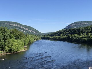
The Delaware River is a major river in the Mid-Atlantic region of the United States and is the longest free-flowing (undammed) river in the Eastern United States. From the meeting of its branches in Hancock, New York, the river flows for 282 miles (454 km) along the borders of New York, Pennsylvania, New Jersey, and Delaware, before emptying into Delaware Bay.

<span class="mw-page-title-main">Camden County, New Jersey</span> County in New Jersey, United States

Camden County is a county located in the U.S. state of New Jersey. Its county seat is Camden. As of the 2020 census, the county was the state's ninth-most populous county, with a population of 523,485, its highest decennial count ever and an increase of 9,828 (+1.9%) from the 2010 census count of 513,657, which in turn reflected an increase of 4,725 (0.9%) from the 508,932 counted in the 2000 census. The county is part of the South Jersey region of the state.

<span class="mw-page-title-main">New Jersey Route 42</span> Highway in New Jersey

Route 42 is a state highway in the U.S. state of New Jersey within the Camden area. It runs 14.28 mi (22.98 km) from an intersection with U.S. Route 322 and County Route 536 Spur in Monroe Township, Gloucester County, to an intersection with Interstate 76 (I-76) and I-295 in Bellmawr, Camden County. The southern portion of Route 42 is an four-lane divided highway and one of several highways comprising the Black Horse Pike, a road that runs from Camden to Atlantic City. The northern portion is part of a six- to eight-lane freeway referred to locally as the North–South Freeway that connects the Atlantic City Expressway to the Benjamin Franklin Bridge. Major junctions along the route include the Atlantic City Expressway and the southern terminus of Route 168 in Turnersville, Route 168 in Blackwood, and Route 41 and Route 55 in Deptford Township.

<span class="mw-page-title-main">Atlantic City Expressway</span> Highway in New Jersey

The Atlantic City Expressway, officially numbered, but unsigned, as Route 446 and abbreviated A.C. Expressway, ACE, or ACX, and known locally as the Expressway, is a 44.19-mile (71.12 km) controlled-access toll road in the U.S. state of New Jersey, managed and operated by the South Jersey Transportation Authority (SJTA). It serves as an extension of the freeway part of Route 42 from Turnersville southeast to Atlantic City. The Atlantic City Expressway is signed as east-west, though the mileage and exits decrease as if one is travelling north-south. It connects Philadelphia and the surrounding Delaware Valley metropolitan area with Atlantic City and other Jersey Shore resorts, and also serves other South Jersey communities, including Hammonton and Mays Landing. The expressway intersects many major roads, including Route 73 in Winslow Township, Route 54 in Hammonton, Route 50 in Hamilton Township, the Garden State Parkway in Egg Harbor Township, U.S. Route 9 (US 9) in Pleasantville, and the Atlantic City–Brigantine Connector near the eastern terminus in Atlantic City.

<span class="mw-page-title-main">SEPTA</span> Public transportation authority

The Southeastern Pennsylvania Transportation Authority (SEPTA) is a regional public transportation authority that operates bus, rapid transit, commuter rail, light rail, and electric trolleybus services for nearly four million people in five counties in and around Philadelphia, Pennsylvania. It also manages projects that maintain, replace and expand its infrastructure, facilities and vehicles.

<span class="mw-page-title-main">NJ Transit</span> Public transportation system

New Jersey Transit Corporation, branded as NJ Transit or NJTransit and often shortened to NJT, is a state-owned public transportation system that serves the U.S. state of New Jersey and portions of the states of New York and Pennsylvania. It operates bus, light rail, and commuter rail services throughout the state, connecting to major commercial and employment centers both within the state and in its two adjacent major cities, New York City and Philadelphia. In 2023, the system had a ridership of 209,259,800.

<span class="mw-page-title-main">New York metropolitan area</span> Metro area surrounding New York City

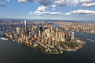
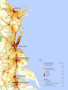
The New York metropolitan area, broadly referred to as the Tri-State area and often also called the Greater New York City Area, is the largest metropolitan area in the world by urban landmass, encompassing 4,669.0 sq mi (12,093 km2). The New York metropolitan area is one of the most populous metropolitan areas in the world and the only U.S. metropolitan area larger than twenty million residents as of the 2020 United States census. The vast metropolitan area includes New York City, the nation's most populous city, Long Island, the Mid- and Lower Hudson Valley in the State of New York; fourteen counties and eleven of the largest cities in New Jersey; and six of the seven largest cities in Connecticut. The phrase "Tri-State area" usually refers to New York / New Jersey / Connecticut, although an increasing number of people who work in New York City commute from Pennsylvania, particularly from the Lehigh Valley, Bucks County, and Poconos regions in eastern Pennsylvania, making the metropolitan area span four states. The New York metropolitan area is the geographic and demographic hub of the larger Northeast megalopolis.

<span class="mw-page-title-main">South Jersey</span> Geographic region of the U.S. state of New Jersey

South Jersey comprises the southern portion of the U.S. state of New Jersey. It is located between Pennsylvania and the lower Delaware River to its west, the Atlantic Ocean to its east, Delaware to its south, and Central Jersey or North Jersey to its north, depending on the definition of North Jersey.

<span class="mw-page-title-main">Index of New Jersey–related articles</span>

The following is an alphabetical list of articles related to the U.S. state of New Jersey.

<span class="mw-page-title-main">Interstate 295 (Delaware–Pennsylvania)</span> Interstate Highway in the US states of Delaware, New Jersey, and Pennsylvania

Interstate 295 (I-295) in Delaware, New Jersey, and Pennsylvania is an auxiliary Interstate Highway, designated as a bypass around Philadelphia, Pennsylvania, and a partial beltway of Trenton, New Jersey.

<span class="mw-page-title-main">Samuel Sloan (architect)</span> American architect

Samuel Sloan was a Philadelphia-based architect and best-selling author of architecture books in the mid-19th century. He specialized in Italianate villas and country houses, churches, and institutional buildings. His most famous building—the octagonal mansion "Longwood" in Natchez, Mississippi—is unfinished; construction was abandoned during the American Civil War.

<span class="mw-page-title-main">Harrisburg–Carlisle metropolitan statistical area</span> Metropolitan area in Pennsylvania, United States

The Harrisburg–Carlisle metropolitan statistical area, officially the Harrisburg–Carlisle, PA Metropolitan Statistical Area, and also referred to as the Susquehanna Valley, is defined by the Office of Management and Budget as an area consisting of three counties in South Central Pennsylvania, anchored by the cities of Harrisburg and Carlisle.

<span class="mw-page-title-main">Metropolitan statistical areas of New Jersey</span> Census subdivisions of New Jersey

New Jersey has seven metropolitan statistical areas (MSAs) defined by the federal Office of Management and Budget. The New York City and Philadelphia MSAs are also divided into divisions, of which there are five in New Jersey. Every statistical area and county in New Jersey belongs to the Northeast Megalopolis.

<span class="mw-page-title-main">U.S. Route 1 in Pennsylvania</span> Highway in Pennsylvania

U.S. Route 1 (US 1) is a major north–south U.S. Route, extending from Key West, Florida, in the south to Fort Kent, Maine, at the Canada–United States border in the north. In the U.S. state of Pennsylvania, US 1 runs for 81 miles (130 km) from the Maryland state line near Nottingham northeast to the New Jersey state line at the Delaware River in Morrisville, through the southeastern portion of the state. The route runs southwest to northeast and serves as a major arterial road through the city of Philadelphia and for many of the suburbs in the Delaware Valley metropolitan area. South of Philadelphia, the road mostly follows the alignment of the Baltimore Pike. Within Philadelphia, it mostly follows Roosevelt Boulevard. North of Philadelphia, US 1 parallels the route of the Lincoln Highway. Several portions of US 1 in Pennsylvania are freeways, including from near the Maryland state line to Kennett Square, the bypass of Media, the concurrency with Interstate 76 and the Roosevelt Expressway in Philadelphia, and between Bensalem Township and the New Jersey state line.

<span class="mw-page-title-main">U.S. Route 30 in New Jersey</span> Highway in New Jersey

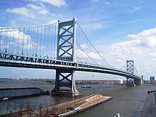
U.S. Route 30 is a U.S. highway running from Astoria, Oregon east to Atlantic City, New Jersey. In the U.S. state of New Jersey, US 30 runs 58.26 miles (93.76 km) from the Benjamin Franklin Bridge at the Delaware River in Camden, Camden County, while concurrent with Interstate 676 (I-676), southeast to Virginia Avenue in Atlantic City, Atlantic County. Most of the route in New Jersey is known as the White Horse Pike and is four lanes wide. The road runs through mostly developed areas in Camden County, with surroundings becoming more rural as the road approaches Atlantic County. US 30 runs through several towns including Collingswood, Berlin, Hammonton, Egg Harbor City, and Absecon.

Costa Rican Americans are Americans of at least partial Costa Rican descent.

<span class="mw-page-title-main">Index of Delaware-related articles</span>

The following is an alphabetical list of articles related to the U.S. state of Delaware.

<span class="mw-page-title-main">Port of Camden</span> Port in United States

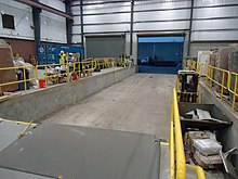
The Port of Camden is situated on east bank of the Delaware River in Camden and Gloucester City in southern New Jersey. It is one of several ports in the Delaware Valley metro area port complex and is located near the mouth of Newtown Creek opposite the Port of Philadelphia. The port is one of the nation's largest for wood products, steel, cocoa and perishable fruit.

<span class="mw-page-title-main">Cincinnati metropolitan area</span> Metropolitan Statistical Area in the United States

The Cincinnati metropolitan area is a metropolitan area with its core in Ohio and Kentucky. Its largest city is Cincinnati and includes surrounding counties in the U.S. states of Ohio, Kentucky, and Indiana.

References

  1. "Welsh Mountain" . Retrieved May 5, 2016.
  2. "MyTopo – Welsh Mountain area" . Retrieved May 5, 2016.
  3. "Total Gross Domestic Product for Philadelphia-Camden-Wilmington, PA-NJ-DE-MD (MSA)". fred.stlouisfed.org.
  4. "Words and Their Stories: Nicknames for Philadelphia and Boston". Voice of America. April 3, 2010. Retrieved July 11, 2017.
  5. Tucker, Laura (November 25, 2014). "Philadelphia". QS Quacquarelli Symonds Limited. Retrieved October 11, 2015.
  6. Eramian, Daniel (November 2, 2020). "Is Philadelphia's biotech cluster faltering? Experts say no". STAT. Retrieved October 24, 2021.
  7. "Q1 2023". PitchBook-NVCA Venture Monitor. April 12, 2023. Retrieved April 14, 2023.
  8. Jon Hurdle (May 13, 2021). "Report details surge in warehouse construction…". NJ Spotlight News. Archived from the original on July 9, 2023. Retrieved January 3, 2023. In South Jersey, the area has become the "epicenter" of warehouse construction in the greater Philadelphia region..'Activity in the Southern New Jersey industrial market continues to amaze,' the report said.
  9. "Greater Philadelphia Economic Development Framework" (PDF). September 2009. Retrieved January 5, 2018.
  10. "Annual Estimates of the Resident Population: April 1, 2010 to July 1, 2016". United States Census Bureau. Archived from the original on February 14, 2020. Retrieved December 30, 2017.
  11. "Local Television Market Universe Estimates" (PDF). Nielsen. The Nielsen Company. September 24, 2016. Retrieved April 11, 2017.
  12. Bond, Michaelle (November 7, 2017). "In historic win, Delco Dems take council seats". Philly.com. Retrieved January 5, 2018.
  13. Stirling, Steven (April 24, 2015). "Here are the North, Central, and South Jersey borders as determined by you (INTERACTIVE)". NJ.com. Retrieved January 5, 2018.
  14. "PHILADELPHIA DESIGNATED MARKET DATA". TruckAds. Retrieved January 4, 2018.
  15. "Community Facts". American FactFinder. United States Census Bureau. Retrieved January 4, 2018.
  16. "Census 2000 PHC-T-29. Ranking Tables for Population of Metropolitan Statistical Areas, Micropolitan Statistical Areas, Combined Statistical Areas, New England City and Town Areas, and Combined New England City and Town Areas: 1990 and 2000" Table 7, released December 30, 2003. Accessed April 22, 2019.
  17. Office of Management and Budget Bulletin 13-01, February 28, 2013, accessed on April 22, 2019, at URL https://www.bls.gov/bls/omb-bulletin-13-01-revised-delineations-of-metropolitan-statistical-areas.pdf
  18. "Global Philadelphia". Global Philadelphia Association. Retrieved February 2, 2015.
  19. ThreadEx; search for location= "PA - Philadelphia", variable= "Station thread"
  20. 1 2 "NowData – NOAA Online Weather Data". National Oceanic and Atmospheric Administration . Retrieved April 13, 2016.
  21. Wood, Anthony R. "Snow total at airport gets a boost A new measuring station and technique likely contributed to two 8-inch-plus readings". Philly.com. The Inquirer. Archived from the original on July 28, 2014. Retrieved June 10, 2014.
  22. "Summary of Monthly Normals 1991–2020". National Oceanic and Atmospheric Administration . Retrieved June 13, 2021.
  23. "WMO Climate Normals for PHILADELPHIA/INT'L ARPT PA 1961–1990". National Oceanic and Atmospheric Administration. Retrieved July 18, 2020.
  24. 1 2 "Philadelphia, Pennsylvania, USA - Monthly weather forecast and Climate data". Weather Atlas. Retrieved May 17, 2019.
  25. Threadex
  26. "NowData – NOAA Online Weather Data". National Oceanic and Atmospheric Administration. Retrieved August 11, 2021.
  27. "Station: Atlantic City, NJ". U.S. Climate Normals 2020: U.S. Monthly Climate Normals (1991–2020). National Oceanic and Atmospheric Administration. Retrieved August 11, 2021.
  28. "U.S. Climate Normals Quick Access – Station: Atlantic City INTL AP, NJ". National Oceanic and Atmospheric Administration. Retrieved February 10, 2023.
  29. "Historical UV Index Data - Atlantic City, NJ". UV Index Today. Retrieved April 22, 2023.
  30. Average weather for Doylestown Weather Channel Retrieved May 12, 2008
  31. 1 2 3 "NowData - NOAA Online Weather Data". National Oceanic and Atmospheric Administration . Retrieved January 30, 2023.
  32. 1 2 3 "Station: Dover, DE". U.S. Climate Normals 2020: U.S. Monthly Climate Normals (1991-2020). National Oceanic and Atmospheric Administration. Retrieved June 18, 2021.
  33. "Dover, Delaware, USA – Monthly weather forecast and Climate data". Weather Atlas. Archived from the original on June 29, 2019. Retrieved July 4, 2019.
  34. Calvin, Claude (1945). The Calvin Families. University of Wisconsin. pp. 47–53, 57–71.
  35. "New Hope-Lambertville Route 202 Toll Bridge". Delaware River Joint Toll Brice Commission. Archived from the original on February 25, 2015.
  36. "General Service – Riverlink Ferry" . Retrieved November 21, 2023.
  37. "Concert Service – Riverlink Ferry" . Retrieved November 21, 2023.
  38. "The 50 best business schools in the world". Business Insider .
  39. Cohen, Micah (October 29, 2012). "In Pennsylvania, the Democratic Lean Is Slight, but Durable". The New York Times . Retrieved January 5, 2018.
  40. Cohen, Micah (July 14, 2012). "In Blue New Jersey, Red Spots May Be Sign of the Past". FiveThirtyEight. Retrieved January 5, 2018.
  41. Cohen, Micah (August 31, 2012). "Delaware: A Small Example of a Larger Trend". FiveThirtyEight. Retrieved January 5, 2018.

Further reading

39°52′37″N75°19′23″W / 39.877°N 75.323°W / 39.877; -75.323