Indiana County, Pennsylvania

Last updated

Indiana County
Indiana County Courthouse.jpg
Indiana County Courthouse
Seal of Indiana County, Pennsylvania.svg
Map of Pennsylvania highlighting Indiana County.svg
Location within the U.S. state of Pennsylvania
Pennsylvania in United States.svg
Pennsylvania's location within the U.S.
Coordinates: 40°39′N79°05′W / 40.65°N 79.09°W / 40.65; -79.09
CountryFlag of the United States.svg United States
StateFlag of Pennsylvania.svg  Pennsylvania
FoundedNovember 3, 1806
Seat Indiana
Largest boroughIndiana
Area
  Total834 sq mi (2,160 km2)
  Land827 sq mi (2,140 km2)
  Water7.3 sq mi (19 km2)  0.9%
Population
 (2020)
  Total83,246
  Density101/sq mi (39/km2)
Time zone UTC−5 (Eastern)
  Summer (DST) UTC−4 (EDT)
Congressional district 15th
Website www.indianacountypa.gov

Indiana County is a county in the Commonwealth of Pennsylvania. It is located in the west central part of Pennsylvania. As of the 2020 census, the population was 83,246. [1] Its county seat is Indiana. [2] Indiana County comprises the Indiana, PA Micropolitan Statistical Area, which is also included in the Pittsburgh-New Castle-Weirton, PA-WV-OH Combined Statistical Area. The county is part of the Southwest Pennsylvania region of the state. [lower-alpha 1]

Contents

Prior to the Revolutionary War, some settlers proposed this as part of a larger, separate colony to be known as Vandalia, but opposing interests and the war intervened. Afterward, claims to the territory by both the states of Virginia and Pennsylvania had to be reconciled. After this land was assigned to Pennsylvania by the federal government according to the placement of the Mason–Dixon line, Indiana County was created on March 30, 1803, from parts of Westmoreland and Clearfield counties and was formally organized in 1806. [3]

History

Indiana County (Indiana meaning "land of the Indians") derives its name from the so-called "Indiana Grant of 1768" that the Iroquois Six Nations were forced to make to "suffering traders" under the Fort Stanwix Treaty of 1768. The Iroquois had controlled much of the Ohio River valley as their hunting grounds since the 17th century, and Anglo-American colonists were moving into the area and wanted to develop it. Traders arranged to force the Iroquois to grant land under the treaty in relations to losses due to Pontiac's Rebellion. [4]

Some of the grantees joined forces with the Ohio Company, forming a larger development company based on enlarging their grant of land. They proposed that the entire large area would become a new British colony, possibly to be called Pittsylvania or Vandalia. It was to be bordered on the north and west by the Ohio River, and made up of what are now parts of eastern Kentucky, northern West Virginia (then part of the Virginia Colony), and western Pennsylvania. Anglo-European colonists from Virginia and Pennsylvania had already started to move into the area, which was identified by these various names as Indiana and the other above names on some maps of the late 1700s. [5] [4]

Opposition from other interest groups [6] and the American Revolutionary War intervened before Britain approved such a colony. Afterward, some United States speculators proposed setting up a state in this area to be called Vandalia, or Westsylvania, as appears on some maps of the period.

But both the states of Virginia and Pennsylvania claimed the land based on their colonial charters. In establishing the Mason–Dixon line, the federal government assigned the Indiana Grant to Pennsylvania. [5] As population increased after the war, this county was made up in 1803 of territory from Westmoreland and Clearfield counties; it was formally organized in 1806. [3]

Kentucky and West Virginia continued to be associated with Virginia for some time, being separately admitted as states in the early 19th century and during the American Civil War, respectively. The area in Pennsylvania was unrelated to and was physically separated from the later named Indiana Territory established north of the Ohio River in 1800 by the new United States; that territory was eventually admitted to the Union as the State of Indiana.

Indiana County was known as a "hotbed of abolition", and was home to at least two African Methodist Episcopal Zion churches as well as other anti-slavery Protestants such as Wesleyan Methodists and Baptists. [7] It was also in Indiana, local abolitionist leader James Moorhead published several anti-slavery newspapers. [8] The first of these was The Clarion of Freedom, founded in 1843. Moorhead eventually sold the Clarion and founded a new anti-slavery paper, the Indiana Independent, which he published until his death in 1857. The Independent was published by his son J. W. Moorhead after his death. Blairsville was home to another abolitionist newspaper, The Appalachian, which was pro-Free Soil from 1848. Some of the nearby anti-slavery families like the Mitchells and Van Leers, became conductors or contributors in 1958. In a letter to abolitionist Theodore Parker, a local geologist Peter Lesley stated there we over 3,000 men helping the railroad in the area. [9]

Indiana County was an active hub of the Underground Railroad. [7] At least 90 county residents are known to have been conductors or agents, guiding fugitive slaves between hiding places on their way to freedom in Canada. [10]

In the 21st century, Indiana County comprises the Indiana, PA Micropolitan Statistical Area. This is included in the Pittsburgh-New Castle-Weirton, PA-WV-OH Combined Statistical Area. [11] It is in the defined region of the Pittsburgh media market. Indiana County is served by three different area codes: 724, 814, and 582.

The county proclaims itself the "Christmas Tree Capital of the World", shipping over one million trees annually. [12] Agriculture is a major part of its economy.

Geography

According to the U.S. Census Bureau, the county has a total area of 834 square miles (2,160 km2), of which 827 square miles (2,140 km2) is land and 7.3 square miles (19 km2) (0.9%) is water. [13] Located in the county is the Buttermilk Falls Natural Area. [14] The county has a humid continental climate which is warm-summer, (Dfb) except along the Conemaugh, from below Strangford and the Kiskiminetas River, where it is hot-summer (Dfa). Average monthly temperatures in the borough of Indiana range from 27.2 °F in January to 70.9 °F in July. [15]

Adjacent counties

Major highways

Historical population
CensusPop.Note
1810 6,214
1820 8,88242.9%
1830 14,25260.5%
1840 20,78245.8%
1850 27,17030.7%
1860 33,68724.0%
1870 36,1387.3%
1880 40,52712.1%
1890 42,1754.1%
1900 42,5560.9%
1910 66,21055.6%
1920 80,91022.2%
1930 75,395−6.8%
1940 79,8545.9%
1950 77,106−3.4%
1960 75,366−2.3%
1970 79,4515.4%
1980 92,28116.1%
1990 89,994−2.5%
2000 89,605−0.4%
2010 88,880−0.8%
2020 83,246−6.3%
[16]

Demographics

As of the census [17] of 2000, there were 89,605 people, 34,123 households, and 22,521 families residing in the county. The population density was 108 inhabitants per square mile (42/km2). There were 37,250 housing units at an average density of 45 units per square mile (17/km2). The racial makeup of the county was 96.87% White, 1.57% Black or African American, 0.08% Native American, 0.74% Asian, 0.01% Pacific Islander, 0.16% from other races, and 0.58% from two or more races. 0.51% of the population were Hispanic or Latino of any race. 25.9% were of German, 11.6% Italian, 10.7% Irish, 8.6% American, 7.1% English and 6.8% Polish ancestry.

There were 34,123 households, out of which 27.90% had children under the age of 18 living with them, 54.30% were married couples living together, 8.20% had a female householder with no husband present, and 34.00% were non-families. 26.50% of all households were made up of individuals, and 11.80% had someone living alone who was 65 years of age or older. The average household size was 2.47 and the average family size was 2.99.

In the county, the population was spread out, with 21.10% under the age of 18, 16.60% from 18 to 24, 24.80% from 25 to 44, 22.70% from 45 to 64, and 14.90% who were 65 years of age or older. The median age was 36 years. For every 100 females, there were 94.00 males. For every 100 females age 18 and over, there were 90.60 males.

2020 census

Indiana County Racial Composition [18]
RaceNum.Perc.
White (NH)75,71891%
Black or African American (NH)2,4092.9%
Native American (NH)1160.14%
Asian (NH)8161%
Pacific Islander (NH)70.01%
Other/Mixed (NH)2,7043.25%
Hispanic or Latino 1,4761.77%

Micropolitan Statistical Area

Map of the Pittsburgh-New Castle-Weirton, PA-OH-WV Combined Statistical Area (CSA) 2013 Pittsburgh Metro Area SMALL.PNG
Map of the Pittsburgh-New Castle-Weirton, PA-OH-WV Combined Statistical Area (CSA)

The United States Office of Management and Budget [19] has designated Indiana County as the Indiana, PA Micropolitan Statistical Area (μSA). As of the 2010 U.S. Census [20] the micropolitan area ranked 4th most populous in the State of Pennsylvania and the 50th most populous in the United States with a population of 88,880. Indiana County is also a part of the Pittsburgh-New Castle-Weirton, PA-OH-WV Combined Statistical Area (CSA), which combines the population of Indiana, as well as the Allegheny, Armstrong, Beaver, Butler, Fayette, Lawrence, Washington and Westmoreland county areas in Pennsylvania. In West Virginia the counties included are Brooke and Hancock. And in Ohio, Jefferson County. The Combined Statistical Area ranked 4th in the State of Pennsylvania and 20th most populous in the United States with a population of 2,660,727.

Government and politics

Indiana County has been strongly Republican in presidential elections for most of its history, only backing Democratic party candidates four times in presidential elections from 1880 to the present day.

United States presidential election results for Indiana County, Pennsylvania [21]
Year Republican Democratic Third party
No.%No.%No.%
2020 28,08968.03%12,63430.60%5661.37%
2016 24,88865.29%11,52830.24%1,7064.48%
2012 21,25758.33%14,47339.71%7141.96%
2008 19,72752.88%17,06545.75%5101.37%
2004 20,25455.88%15,83143.67%1630.45%
2000 16,79953.50%13,66743.52%9352.98%
1996 12,87442.10%13,86845.35%3,84112.56%
1992 10,96632.92%15,19445.61%7,15421.47%
1988 14,98347.21%16,51452.03%2420.76%
1984 18,84554.22%15,79145.43%1230.35%
1980 15,60749.62%13,82843.97%2,0166.41%
1976 15,78651.01%14,65047.34%5131.66%
1972 18,12261.90%10,83337.01%3191.09%
1968 14,89951.03%12,17541.70%2,1227.27%
1964 11,70639.92%17,56859.92%460.16%
1960 18,75658.59%13,17441.15%830.26%
1956 18,59362.27%11,26837.73%00.00%
1952 16,67358.63%11,62040.86%1470.52%
1948 12,64059.67%8,54340.33%00.00%
1944 14,38861.42%8,86337.83%1750.75%
1940 15,54756.23%12,03543.53%680.25%
1936 16,53051.37%15,35347.71%2940.91%
1932 12,72757.24%8,60638.70%9024.06%
1928 16,70676.75%4,81022.10%2521.16%
1924 12,74869.75%2,06711.31%3,46218.94%
1920 8,61671.84%1,93616.14%1,44112.02%
1916 4,88757.65%2,39828.29%1,19214.06%
1912 1,72020.21%1,59318.72%5,19761.07%
1908 6,41667.44%1,96520.65%1,13311.91%
1904 6,87877.25%1,55817.50%4685.26%
1900 5,68772.25%1,76722.45%4175.30%
1896 5,81866.11%2,75231.27%2312.62%
1892 4,55961.18%2,13428.64%75910.19%
1888 5,08462.83%2,23127.57%7779.60%

As of February 5, 2024, there were 48,654 registered voters across Indiana County's 69 precincts: 27,290 Republicans (56.09%); 15,193 Democrats (31.23%), 4,334 Independents (8.91%) and 1,837 from other parties (3.77%). [22]

Chart of Voter Registration

   Republican (56.09%)
   Democratic (31.23%)
   Independent (8.91%)
   Other Parties (3.77%)

County commissioners

  • Michael Keith, chairman, Republican
  • Robin Gorman, Republican
  • Sherene Hess, Democrat

Other county offices

  • Coroner, Jerry L Overman Jr, Republican
  • District Attorney, Robert Manzi, Republican
  • Prothonotary, Randy Degenkolb, Republican
  • Recorder of Deeds and Register of Wills, Maria Jack, Republican
  • Sheriff, Robert Fyock, Republican
  • Treasurer, Kimberly McCullough, Republican
  • Board of Auditors, Donna Cupp, Republican; Bonni S. Dunlap, Ph.D., Republican; James P. Smith Jr., Democrat

State representatives

Source: [23]

State senator

United States representative

United States senators

Education

Map of Indiana County, Pennsylvania Public School Districts Map of Indiana County Pennsylvania School Districts.png
Map of Indiana County, Pennsylvania Public School Districts

Public school districts

Post-secondary education

Environment

In 2003, the county was recommended for non-attainment under EPA ozone standards based upon mobile source contribution to smog-forming emissions. [24]

The county is the site of the Homer City Generating Station, a coal-burning power plant. In 2002 the plant was ranked as second in emissions in the Toxics Release Inventory (TRI) in Pennsylvania. [25] In 2003, the plant ranked high in the emissions of both sulfur dioxide and carbon dioxide, ranking 4th and 28th, respectively, in the nation. [26] Such toxic emissions are injurious to people and other living things.

Communities

Map of Indiana County, Pennsylvania with Municipal Labels showing Boroughs (red), Townships (white), and Census-designated places (blue). Map of Indiana County Pennsylvania With Municipal and Township Labels.png
Map of Indiana County, Pennsylvania with Municipal Labels showing Boroughs (red), Townships (white), and Census-designated places (blue).

Under Pennsylvania law, there are four types of incorporated municipalities: cities, boroughs, townships, and, in at most two cases, towns. The following boroughs and townships are located in Indiana County:

Boroughs

Townships

Census-designated places

Census-designated places are geographical areas designated by the U.S. Census Bureau for the purposes of compiling demographic data. They are not actual jurisdictions under Pennsylvania law. Other unincorporated communities, such as villages, may be listed here as well.

Unincorporated communities

Population ranking

The population ranking of the following table is based on the 2010 census of Indiana County. [20]

*county seat

RankCity/Town/etc.Municipal typePopulation (2010 Census)
1* Indiana Borough13,975
2 Blairsville Borough3,412
3 Homer City Borough1,707
4 Chevy Chase Heights CDP1,502
5 Black Lick CDP1,462
6 Clymer Borough1,357
7 Lucerne Mines CDP937
8 Saltsburg Borough873
9 Heilwood CDP711
10 Rossiter CDP646
11 Jacksonville CDP637
12 Robinson CDP614
13 Dixonville CDP467
14 Ernest Borough462
15 Marion Center Borough451
16 Cherry Tree Borough364
17 Commodore CDP331
18 Coral CDP325
19 Creekside Borough309
20 Plumville Borough307
21 Graceton CDP257
22 Glen Campbell Borough245
23 Shelocta Borough130
24 Armagh Borough122
25 Smicksburg Borough46

Notable people

See also

Related Research Articles

<span class="mw-page-title-main">Allegheny County, Pennsylvania</span> County in Pennsylvania, United States

Allegheny County is a county in Pennsylvania, United States. As of the 2020 census, the population was 1,250,578, making it the state's second-most populous county, after Philadelphia County. Its county seat and most populous city is Pittsburgh, Pennsylvania's second most populous city. The county is part of the Greater Pittsburgh region of the state, and is the center of the Pittsburgh media market.

<span class="mw-page-title-main">Armstrong County, Pennsylvania</span> County in Pennsylvania, United States

Armstrong County is a county in the Commonwealth of Pennsylvania. As of the 2020 census, the population was 65,558. The county seat is Kittanning. The county was organized on March 12, 1800, from parts of Allegheny, Westmoreland and Lycoming Counties. It was named in honor of John Armstrong, who represented Pennsylvania in the Continental Congress and served as a major general during the Revolutionary War.

<span class="mw-page-title-main">Brooke County, West Virginia</span> County in West Virginia, United States

Brooke County is a county in the Northern Panhandle of the U.S. state of West Virginia. As of the 2020 census, the population was 22,559. Its county seat is Wellsburg. The county was created in 1797 from part of Ohio County and named in honor of Robert Brooke, Governor of Virginia from 1794 to 1796. Brooke County is part of the Weirton-Steubenville, WV-OH Metropolitan Statistical Area, which is also included in the Pittsburgh-New Castle-Weirton, PA-WV-OH Combined Statistical Area.

<span class="mw-page-title-main">Westmoreland County, Pennsylvania</span> County in Pennsylvania, United States

Westmoreland County is a county in the Commonwealth of Pennsylvania, United States, located in the Pittsburgh Metropolitan Statistical Area. As of the 2020 census, the population was 354,663. The county seat is Greensburg and the most populous community is Hempfield Township. It is named after Westmorland, a historic county of England. The county is part of the Southwest Pennsylvania region of the state.

<span class="mw-page-title-main">Somerset County, Pennsylvania</span> County in Pennsylvania, United States

Somerset County is a county in the Commonwealth of Pennsylvania. As of the 2020 census, the population was 74,129. Its county seat is Somerset. The county was created from part of Bedford County on April 17, 1795, and named after the county of Somerset in England. The county is part of the Southwest Pennsylvania region of the state.

<span class="mw-page-title-main">Mercer County, Pennsylvania</span> County in Pennsylvania, United States

Mercer County is a county in the Commonwealth of Pennsylvania. As of the 2020 census, the population was 110,652. Its county seat is Mercer, and its largest city is Hermitage. The county is part of the Northwest Pennsylvania region of the state.

<span class="mw-page-title-main">McKean County, Pennsylvania</span> County in Pennsylvania, United States

McKean County is a rural county in the Commonwealth of Pennsylvania. As of the 2020 census, the population was 40,432. Its county seat is Smethport. The county was created in 1804 and organized in 1826. It was named in honor of former Pennsylvania Governor and Declaration of Independence signer Thomas McKean. The county is part of the North Central Pennsylvania region of the state.

<span class="mw-page-title-main">Huntingdon County, Pennsylvania</span> County in Pennsylvania, United States

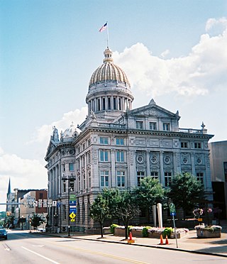
Huntingdon County is a county in the Commonwealth of Pennsylvania. As of the 2020 census, the population was 44,092. Its county seat is Huntingdon. The county was created on September 20, 1787, mainly from the northern part of Bedford County, plus an addition of territory on the east from Cumberland County. The county is part of the Southwest Pennsylvania region of the state.

<span class="mw-page-title-main">Greene County, Pennsylvania</span> County in Pennsylvania, United States

Greene County is a county in the Commonwealth of Pennsylvania. As of the 2020 census, the population was 35,954. Its county seat is Waynesburg. Greene County was created on February 9, 1796, from part of Washington County and named for General Nathanael Greene. The county is part of the Southwest Pennsylvania region of the state.

<span class="mw-page-title-main">Fayette County, Pennsylvania</span> County in Pennsylvania, United States

Fayette County is a county in the Commonwealth of Pennsylvania. It is located in southwestern Pennsylvania, adjacent to Maryland and West Virginia. As of the 2020 census, the population was 128,804. Its county seat is Uniontown. The county was created on September 26, 1783, from part of Westmoreland County and named after the Marquis de Lafayette. The county is part of the Southwest Pennsylvania region of the state.

<span class="mw-page-title-main">Cambria County, Pennsylvania</span> County in Pennsylvania, United States

Cambria County is a county in the Commonwealth of Pennsylvania. As of the 2020 census, the population was 133,472. Its county seat is Ebensburg. The county was created on March 26, 1804, from parts of Bedford, Huntingdon, and Somerset counties and later organized in 1807. It was named for the nation of Wales, which in Latin is known as "Cambria". The county is part of the Southwest Pennsylvania region of the state.

<span class="mw-page-title-main">Bradford County, Pennsylvania</span> County in Pennsylvania, United States

Bradford County is a county in the Commonwealth of Pennsylvania. As of the 2020 census, its population was 59,967. Its county seat is Towanda. The county was created on February 21, 1810, from parts of Lycoming and Luzerne Counties. Originally called Ontario County, it was reorganized and separated from Lycoming County on October 13, 1812, and renamed Bradford County for William Bradford, who had been a chief justice of the Pennsylvania Supreme Court and United States Attorney General. The county is part of the Northeast Pennsylvania region of the state.

<span class="mw-page-title-main">Blairsville, Pennsylvania</span> Borough in Pennsylvania, United States

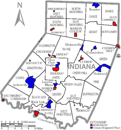
Blairsville is a borough in Indiana County, Pennsylvania, United States, located 42 miles (68 km) east of Pittsburgh, and on the Conemaugh River. As of the 2020 census it had a population of 3,252.

<span class="mw-page-title-main">Indiana, Pennsylvania</span> Borough in Pennsylvania, United States

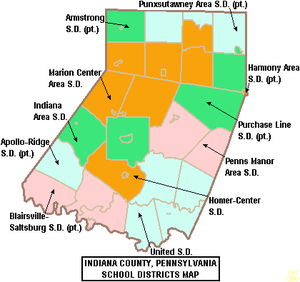
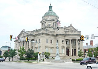
Indiana is a borough in and the county seat of Indiana County, Pennsylvania, United States. The population was 14,044 at the 2020 census. It is the principal city of the Indiana, Pennsylvania micropolitan area, about 46 miles (74 km) northeast of Pittsburgh. It is a part of the greater Pittsburgh–New Castle–Weirton combined statistical area, as well as the Johnstown and Pittsburgh media markets.

<span class="mw-page-title-main">Marion Center, Pennsylvania</span> Borough in Pennsylvania, United States

Marion Center is a borough in Indiana County, Pennsylvania, United States. The population was 413 at the 2020 census.

<span class="mw-page-title-main">Greensburg, Pennsylvania</span> City in Pennsylvania, United States

Greensburg is a city in and the county seat of Westmoreland County, Pennsylvania, United States. The population was 14,976 at the 2020 census. Located 30 miles (48 km) southeast of Pittsburgh, Greensburg is a part of the Pittsburgh metropolitan area. The city lies within the Laurel Highlands and the ecoregion of the Western Allegheny Plateau. The city is named after Nathanael Greene, a major general of the Continental Army in the American Revolutionary War.

<span class="mw-page-title-main">Greater Pittsburgh</span> Region in the U.S. State of Pennsylvania

Greater Pittsburgh is the metropolitan area surrounding the city of Pittsburgh in Western Pennsylvania, United States. The region includes Allegheny County, Pittsburgh's urban core county and economic hub, and seven adjacent Pennsylvania counties: Armstrong, Beaver, Butler, Fayette, Lawrence, Washington, and Westmoreland in Western Pennsylvania, which constitutes the Pittsburgh, PA Metropolitan Statistical Area MSA as defined by the U.S. Census Bureau.

<span class="mw-page-title-main">U.S. Route 119 in Pennsylvania</span> Segment of American highway

U.S. Route 119 (US 119) travels through Connellsville, Greensburg, and Punxsutawney, and bypasses Uniontown and Indiana. There are numerous other boroughs and villages along its 133-mile (214 km) route in the Keystone State. The southern entrance of US 119 is at the West Virginia state line one-half-mile south of Point Marion. The northern terminus is at US 219 two miles (3 km) south of DuBois, Pennsylvania. US 119 is in the National Highway System from the West Virginia state line to Exit 0 of PA Turnpike 66, and from US 22 to US 219. From US 22 to US 219, the highway carries the name of the Buffalo-Pittsburgh Highway; from US 22 to PA 56, it is also known as the Patrick J. Stapleton Highway; near Uniontown, it bears the name George C. Marshall Parkway.

<span class="mw-page-title-main">Lawrence County, Pennsylvania</span> County in Pennsylvania, United States

Lawrence County is a county in the Commonwealth of Pennsylvania. As of the 2020 census, the population was 86,070. The county seat and largest city is New Castle.

<span class="mw-page-title-main">Pittsburgh–New Castle–Weirton combined statistical area</span> Metropolitan area in the United States

The Pittsburgh–Weirton–Steubenville, PA–OH–WV Combined Statistical Area is a 13-county combined statistical (CSA) in the United States. The largest and principal in the area is Pittsburgh, Pennsylvania, but the CSA includes population centers from three states: Pennsylvania, West Virginia, and Ohio.

References

  1. Includes Westmoreland, Cambria, Fayette, Blair, Indiana, Somerset, Bedford, Huntingdon, Greene and Fulton Counties
  1. "Census - Geography Profile: Indiana County, Pennsylvania". United States Census Bureau . Retrieved December 18, 2022.
  2. "Find a County". National Association of Counties. Archived from the original on May 31, 2011. Retrieved June 7, 2011.
  3. 1 2 "Pennsylvania: Individual County Chronologies". Pennsylvania Atlas of Historical County Boundaries. The Newberry Library. 2008. Archived from the original on March 25, 2015. Retrieved March 12, 2015.
  4. 1 2 Anderson, James Donald, "Vandalia: The First West Virginia?" West Virginia History, Volume 40, No. 4 (Summer 1979), pp. 375-92 online
  5. 1 2 David W. Miller. The Taking of American Indian Lands in the Southeast: A History of Territorial Cessions and Forced Relocations, 1607-1840. McFarland, 2011. p. 41. ISBN   978-0-7864-6277-3
  6. Gipson, Lawrence Henry, The British Empire Before the American Revolution, 15 vols. New York: Alfred A. Knopf, 1946-1970, IX 457-88
  7. 1 2 Archives, Special Collections and University; Stapleton Library, Room 302 431 South Eleventh Street Indiana; Phone: 724-357-3039; Fax: 724-357-4891. "Indiana County and the Underground Railroad". Indiana University of Pennsylvania. Retrieved May 2, 2022.{{cite web}}: CS1 maint: numeric names: authors list (link)
  8. Archives, Special Collections and University; Stapleton Library, Room 302 431 South Eleventh Street Indiana; Phone: 724-357-3039; Fax: 724-357-4891. "Antislavery Newspapers". Indiana University of Pennsylvania. Retrieved May 2, 2022.{{cite web}}: CS1 maint: numeric names: authors list (link)
  9. "Our UGRR Conductors & Incidents". Blairsville Area Underground Railroad.
  10. "Our UGRR Conductors & Incidents". Blairsville Area Underground Railroad. Retrieved May 2, 2022.
  11. "Archived copy" (PDF). Office of Management and Budget . Archived (PDF) from the original on January 21, 2017. Retrieved January 4, 2017 via National Archives.{{cite web}}: CS1 maint: archived copy as title (link)
  12. "'Tis the season for tree farmers". Pittsburgh Tribune-Review . December 20, 2004. Archived from the original on October 22, 2006. Retrieved May 16, 2006.
  13. "2010 Census Gazetteer Files". United States Census Bureau. August 22, 2012. Retrieved March 7, 2015.
  14. "Buttermilk Falls Natural Area". Indiana County Parks and Trails.
  15. "PRISM Climate Group at Oregon State University". prism.oregonstate.edu.
  16. "Census 2020".
  17. "U.S. Census website". United States Census Bureau . Retrieved January 31, 2008.
  18. "P2 HISPANIC OR LATINO, AND NOT HISPANIC OR LATINO BY RACE – 2020: DEC Redistricting Data (PL 94-171) – Indiana County, Pennsylvania".
  19. "Office of Management and Budget". whitehouse.gov. Retrieved March 28, 2018.
  20. 1 2 "2010 U.S. Census website". United States Census Bureau . Retrieved February 13, 2016.
  21. Leip, David. "Dave Leip's Atlas of U.S. Presidential Elections". uselectionatlas.org. Retrieved March 28, 2018.
  22. Pennsylvania Department of State (February 5, 2024). "Voter registration statistics by county". dos.pa.gov. Retrieved February 5, 2024.
  23. 1 2 Center, Legislativate Data Processing. "Find Your Legislator". The official website for the Pennsylvania General Assembly. Retrieved May 3, 2017.
  24. "Figure 3. Mobile Source Contribution to Smog-Forming Emissions in Counties Recommended for Nonattainment under New EPA Ozone Standards". Surface Transportation Policy Project. April 16, 2004. Archived from the original on September 27, 2006. Retrieved May 16, 2006.
  25. "Pa. ranks among worst states for toxic emissions". Pittsburgh Tribune-Review . November 18, 2002. Archived from the original on May 24, 2007. Retrieved May 16, 2006.
  26. Environmental Integrity Project & Public Citizen's Congress Watch (May 2004). "America's Dirtiest Power Plants: Plugged into the Bush Administration" (PDF). Archived from the original (PDF) on April 13, 2006. Retrieved May 16, 2006.{{cite journal}}: Cite journal requires |journal= (help)

40°39′N79°05′W / 40.65°N 79.09°W / 40.65; -79.09