Montgomery County, Pennsylvania

Last updated

Montgomery County
Montgomery County Courthouse Pennsylvania - Douglas Muth.jpg
Flag of Montgomery County, Pennsylvania.png
Coat of arms of Montgomery County, Pennsylvania.png
Nickname: 
Montco [1]
Map of Pennsylvania highlighting Montgomery County.svg
Location within the U.S. state of Pennsylvania
Pennsylvania in United States.svg
Pennsylvania's location within the U.S.
Coordinates: 40°13′N75°22′W / 40.21°N 75.37°W / 40.21; -75.37
CountryFlag of the United States.svg United States
StateFlag of Pennsylvania.svg  Pennsylvania
FoundedSeptember 10, 1784
Named for Richard Montgomery or Montgomeryshire
Seat Norristown
Largest municipality Lower Merion Township
Government
  County CommissionersJamila H. Winder, Chair
Neil K. Makhija, Vice Chair
Thomas DiBello, Commissioner
Area
  Total487 sq mi (1,260 km2)
  Land483 sq mi (1,250 km2)
  Water4.2 sq mi (11 km2)  0.9%
Population
 (2020)
  Total856,553
  Estimate 
(2022)
864,683Increase2.svg
  Density1,773/sq mi (685/km2)
Time zone UTC−5 (Eastern)
  Summer (DST) UTC−4 (EDT)
Congressional districts 1st, 4th, 5th
Website www.montcopa.org
Montgomery County, Pennsylvania
Interactive map of Montgomery County, Pennsylvania

Montgomery County, colloquially referred to as Montco, [1] is a county in the Commonwealth of Pennsylvania. As of the 2020 census, the population of the county was 856,553, making it the third-most populous county in Pennsylvania after Philadelphia and Allegheny counties. [2] The county is part of the Southeast Pennsylvania region of the state. [lower-alpha 1]

Contents

The county seat and largest city is Norristown. [3] The county is part of the PhiladelphiaCamdenWilmington PA-NJDEMD metropolitan statistical area, known as the Delaware Valley, and marks the Delaware Valley's northern border with the Lehigh Valley region of eastern Pennsylvania.

The county borders Philadelphia, the nation's sixth-largest city, to its southeast, Bucks County to its east, Berks and Lehigh counties to its north, Delaware County to its south, and Chester County to its southwest.

The county was created on September 10, 1784, out of land originally part of Philadelphia County. The first courthouse was housed in the Barley Sheaf Inn. It is believed to have been named either for Richard Montgomery, an American Revolutionary War general killed in 1775 while attempting to capture Quebec City, or for the Welsh county of Montgomeryshire, which was named after one of William the Conqueror's main counselors, Roger de Montgomerie, since it was part of the Welsh Tract, an area of Pennsylvania settled by Quakers from Wales. [4]

Geography

According to the U.S. Census Bureau, the county has a total area of 487 square miles (1,260 km2), 483 square miles (1,250 km2) of which was land and 4.2 square miles (11 km2) (0.9%) of which was water. [5]

Adjacent counties

National protected area

County-owned parks [6]

ParkAcresTrail Miles
Central Perkiomen Valley Park 80019
Green Lane Park 3,40025
Lock 60 at Schuylkill Canal Park -5
Lorimer Park2305.4
Lower Perkiomen Valley Park107-
Norristown Farm Park6908
Upper Schuylkill Valley Park15-

Demographics

Historical population
CensusPop.Note
1790 22,918
1800 24,1505.4%
1810 29,70323.0%
1820 35,79320.5%
1830 39,40610.1%
1840 47,24119.9%
1850 58,29123.4%
1860 70,50020.9%
1870 81,61215.8%
1880 96,49418.2%
1890 123,29027.8%
1900 138,99512.7%
1910 169,59022.0%
1920 199,31017.5%
1930 265,80433.4%
1940 289,2478.8%
1950 353,06822.1%
1960 516,68246.3%
1970 623,79920.7%
1980 643,6213.2%
1990 678,1115.4%
2000 750,09710.6%
2010 799,8846.6%
2020 856,5537.1%
2022 (est.)864,683 [7] 0.9%
U.S. Decennial Census [8]
1790–1960 [9] 1900–1990 [10]
1990–2000 [11] 2010–2020 [2]

2020 census

As of the 2020 census, the county was 73.27% White (72.18% White, non-Hispanic), 9.55% Black or African American, 0.22% Native American or Alaskan Native, 7.94% Asian, 0.02% Pacific Islander, and 2.87% some other race; 6.13% were two or more races. 6.36% of the population were Hispanic or Latino of any race. [12]

Montgomery County Racial Composition [13]
RaceNum.Perc.
White (NH)618,24472.2%
Black or African American (NH)79,5109.3%
Native American (NH)7630.1%
Asian (NH)67,7618%
Pacific Islander (NH)1680.02%
Other/Mixed (NH)35,5954.2%
Hispanic or Latino 54,5126.4%

The largest townships/boroughs in Montgomery County include:

Township/boroughPopulation (2010 US Census)Density mi2
Lower Merion Township 57,8252,526.1
Abington Township 55,3103,630.3
Cheltenham Township 36,7934,083.1
Municipality of Norristown 34,3249,806.9
Upper Merion Township 28,3951,593.3
Horsham Township 26,1471,398.6
Upper Dublin Township 25,5691,960.7
Lower Providence Township 25,4361,458.8
Montgomery Township 24,7902,067.1
Upper Moreland Township 24,0153,202

Economy

CheltTwp 18.JPG
Perkiomen Creek 2006.jpg
Montgomery County ranges from the densely populated rowhouse streets of Cheltenham Township (top) to the forests and open land around Perkiomen Creek in the northern part of the county (bottom).

Montgomery County is a suburb of Philadelphia, the nation's sixth most populous city. Many Montco residents work in the city, but the county is also a major employment center with large business parks in Blue Bell, Lansdale, Fort Washington, Horsham, and King of Prussia attracting thousands of workers from all over the region. The strong job base and taxes generated by those jobs have resulted in Montgomery County receiving the highest credit rating of 'AAA' from Standard & Poor's, one of fewer than 30 counties in the United States with such a rating. [14] In 2012, Moody's downgraded the general obligation rating to Aa1, [15] and in 2018 the rating was revised back to Aaa. [16]

Major employers include: [17]

Education

Colleges and universities

Public school districts

Map of Montgomery County public school districts Map of Montgomery County Pennsylvania School Districts.png
Map of Montgomery County public school districts

School districts: [18]

Private secondary schools

Night schools/adult education

Communities

Map of Montgomery County with municipal labels showing boroughs (red), townships (white), and census-designated places (blue) Map of Montgomery County Pennsylvania With Municipal and Township Labels.png
Map of Montgomery County with municipal labels showing boroughs (red), townships (white), and census-designated places (blue)

Under Pennsylvania law, five types of incorporated municipalities are listed: cities, boroughs, townships, home rule municipalities (which can include communities that bear the name "Borough" or "Township") and, in at most two cases, towns. These boroughs, townships, and home rule municipalities are located in Montgomery County:

Home rule municipalities

Boroughs

Townships

Census-designated places

Census-designated places are geographical areas designated by the United States Census Bureau for the purposes of compiling demographic data. They are not actual jurisdictions under Pennsylvania law. Other unincorporated communities, such as villages, may be listed here, as well.

Even though the historic village of Valley Forge, as well as the park, are partially located within Montgomery County, the modern village is in Chester County, PA

Unincorporated communities

Population ranking

The population ranking of the following table is based on the 2010 census of Montgomery County. [21]

county seat

RankCity/Town/etc.Municipal typePopulation (2010 Census)
1 Norristown Municipality34,324
2 Pottstown Borough22,377
3 King of Prussia CDP19,936
4 Lansdale Borough16,269
5 Willow Grove CDP15,726
6 Horsham CDP14,842
7 Montgomeryville CDP12,624
8 Ardmore (partially in Delaware County )CDP12,455
9 Harleysville CDP9,286
10 Audubon CDP8,433
11 Glenside CDP8,384
12 Sanatoga CDP8,378
13 Kulpsville CDP8,194
14 Conshohocken Borough7,833
15 Hatboro Borough7,360
16 Maple Glen CDP6,742
17 Souderton Borough6,618
18 Ambler Borough6,417
19 Plymouth Meeting CDP6,177
20 Blue Bell CDP6,067
21 Trooper CDP5,744
22 Penn Wynne CDP5,697
23 Oreland CDP5,678
24 Wyndmoor CDP5,498
25 Fort Washington CDP5,446
26 Collegeville Borough5,089
27 Telford (partially in Bucks County )Borough4,872
28 Gilbertsville CDP4,832
29 Eagleville CDP4,800
30 Royersford Borough4,752
31 Bridgeport Borough4,554
32 Flourtown CDP4,538
33 Jenkintown Borough4,422
34 Narberth Borough4,282
35 Gladwyne CDP4,050
36 Pennsburg Borough3,843
37 Spring House CDP3,804
38 Bryn Mawr CDP3,779
39 Skippack CDP3,758
40 Stowe CDP3,695
41 Trappe Borough3,509
42 Pottsgrove CDP3,469
43 Hatfield Borough3,290
44 North Wales Borough3,229
45 Wyncote CDP3,044
46 East Greenville Borough2,951
47 Halfway House CDP2,881
48 Rockledge Borough2,543
49 Red Hill Borough2,383
50 Spring Mount CDP2,259
51 Evansburg CDP2,129
52 Schwenksville Borough1,385
53 Bryn Athyn Municipality1,375
54 Haverford College (mostly in Delaware County)CDP1,331
55 West Conshohocken Borough1,320
56 Woxhall CDP1,318
57 Arcadia University CDP595
58 Green Lane Borough508

Transportation

Major roads and highways

I-276/Pennsylvania Turnpike eastbound at the Interstate 476/Pennsylvania Turnpike Northeast Extension in Montgomery County 2022-10-11 11 58 25 View east along Interstate 276 (Pennsylvania Turnpike Delaware River Extension) from the overpass for Interstate 476 (Pennsylvania Turnpike Northeast Extension) in Plymouth Township, Montgomery County, Pennsylvania.jpg
I-276/Pennsylvania Turnpike eastbound at the Interstate 476/Pennsylvania Turnpike Northeast Extension in Montgomery County

Public transportation

The county is served by the SEPTA, which include bus, commuter rail, and interurban rail services. Pottstown Area Rapid Transit (PART) also provides bus services around the Pottstown area in the western portion of the county. [22]

Airports

Commercial airline service is provided primarily by Philadelphia International Airport, one of the nation's largest commercial airports, located in Philadelphia and Delaware counties. [23]

Other public use airports include Heritage Field in Limerick Township, Wings Field in Blue Bell, and Pottstown Municipal Airport in Pottstown.

Culture

Climate

The majority of the county has a hot-summer humid continental climate (Dfa). In most southern areas of the county and along the Schuylkill River including Pottstown a humid subtropical climate (Cfa) exists. The hardiness zone is 7a for the majority of the county and 7b in most areas south of Interstate 276. 6b only continues to exist in some very small higher areas in the north.

Climate data for Upper Hanover Twp (Elevation: 489 ft; 149 m) 1981 - 2010 Averages
MonthJanFebMarAprMayJunJulAugSepOctNovDecYear
Mean daily maximum °F (°C)37.8
(3.2)
41.1
(5.1)
49.8
(9.9)
61.7
(16.5)
72.1
(22.3)
80.8
(27.1)
84.9
(29.4)
83.2
(28.4)
76.2
(24.6)
64.5
(18.1)
53.3
(11.8)
41.8
(5.4)
62.4
(16.9)
Daily mean °F (°C)29.3
(−1.5)
31.9
(−0.1)
39.7
(4.3)
50.5
(10.3)
60.4
(15.8)
69.5
(20.8)
74.0
(23.3)
72.3
(22.4)
64.8
(18.2)
53.2
(11.8)
43.5
(6.4)
33.5
(0.8)
52.0
(11.1)
Mean daily minimum °F (°C)20.8
(−6.2)
22.7
(−5.2)
29.6
(−1.3)
39.2
(4.0)
48.7
(9.3)
58.3
(14.6)
63.0
(17.2)
61.4
(16.3)
53.4
(11.9)
41.9
(5.5)
33.7
(0.9)
25.2
(−3.8)
41.6
(5.3)
Average precipitation inches (mm)3.27
(83)
2.71
(69)
3.55
(90)
3.86
(98)
4.27
(108)
4.21
(107)
4.83
(123)
3.90
(99)
4.63
(118)
4.26
(108)
3.65
(93)
3.75
(95)
46.89
(1,191)
Average relative humidity (%)68.465.160.659.563.669.069.071.872.971.470.470.767.7
Average dew point °F (°C)20.2
(−6.6)
21.5
(−5.8)
27.2
(−2.7)
36.9
(2.7)
48.0
(8.9)
58.9
(14.9)
63.2
(17.3)
62.7
(17.1)
55.9
(13.3)
44.2
(6.8)
34.5
(1.4)
25.0
(−3.9)
41.6
(5.3)
Source: PRISM [24]
Climate data for Cheltenham (Elevation: 125 ft; 38 m) 1981 - 2010 Averages
MonthJanFebMarAprMayJunJulAugSepOctNovDecYear
Mean daily maximum °F (°C)40.6
(4.8)
43.9
(6.6)
52.0
(11.1)
63.3
(17.4)
73.0
(22.8)
82.3
(27.9)
86.3
(30.2)
84.9
(29.4)
78.0
(25.6)
66.7
(19.3)
55.9
(13.3)
44.9
(7.2)
64.4
(18.0)
Daily mean °F (°C)33.2
(0.7)
35.9
(2.2)
43.2
(6.2)
53.7
(12.1)
63.2
(17.3)
72.8
(22.7)
77.3
(25.2)
76.0
(24.4)
68.8
(20.4)
57.3
(14.1)
47.5
(8.6)
37.7
(3.2)
55.6
(13.1)
Mean daily minimum °F (°C)25.8
(−3.4)
27.8
(−2.3)
34.3
(1.3)
44.0
(6.7)
53.4
(11.9)
63.2
(17.3)
68.4
(20.2)
67.1
(19.5)
59.6
(15.3)
48.0
(8.9)
39.2
(4.0)
30.4
(−0.9)
46.9
(8.3)
Average precipitation inches (mm)3.46
(88)
2.77
(70)
4.10
(104)
3.92
(100)
4.15
(105)
4.12
(105)
4.96
(126)
4.24
(108)
4.29
(109)
3.71
(94)
3.52
(89)
3.92
(100)
47.16
(1,198)
Average relative humidity (%)65.561.657.357.261.463.565.066.968.067.966.566.664.0
Average dew point °F (°C)22.9
(−5.1)
24.0
(−4.4)
29.1
(−1.6)
38.9
(3.8)
49.7
(9.8)
59.7
(15.4)
64.6
(18.1)
64.2
(17.9)
57.8
(14.3)
46.8
(8.2)
36.9
(2.7)
27.6
(−2.4)
43.6
(6.4)
Source: PRISM [24]

Politics

As of March 4, 2024, there are 606,385 registered voters in Montgomery County. [25]

Montgomery County historically was a stronghold for the Republican Party. The county was the only one carried by Barbara Hafer in the 1990 gubernatorial election over the incumbent governor, Bob Casey. However, the Democratic Party has made substantial gains in the county over the last quarter-century and gained the registration edge early in 2008.

Like neighboring Bucks County, the county voted Democratic during the Civil War era, voting Democratic between 1856 and 1876, except in 1860 and 1872. Like most of Philadelphia's suburbs, the brand of Republicanism practiced in Montgomery County for much of the 20th century was moderate. As the national parties have polarized, the county's voters have increasingly supported Democrats at the national level. The county voted for the Republican presidential nominee in all but two elections from 1880 to 1988, that being in 1892 and 1964. However, Montgomery County residents have voted for the Democratic presidential nominee since 1992, with the margins progressively increasing between every election, except in 2012. In the 2020 election, Joe Biden became the first Democrat to obtain over 60% of the county's vote.

Despite Donald Trump's victory in the state of Pennsylvania in the 2016 presidential election, Montgomery County was one of the few counties in Pennsylvania that swung in the Democratic presidential candidates' direction with Hillary Clinton winning Montgomery County with 58.87% of the vote, an improvement from Barack Obama's 56.6% vote share in 2012. In the 2016 U.S. Senate and Pennsylvania Attorney General elections, Montgomery County voted for Katie McGinty and Josh Shapiro, both Democrats. [26]

Most county-level offices were held by Republicans until after the 2007 election, when Democrats picked up control of five row offices. Democrats have also won several elections in the Pennsylvania General Assembly in recent years, including two GOP-leaning State House districts in 2004, the 148th with Mike Gerber and the 153rd with current Governor Josh Shapiro. Today, although the county is very Democratic at the national level, at the state and local level, it is not specifically partisan.

In the 2004 United States Senate election, Republican Arlen Specter won the county over Montco resident Joe Hoeffel, but Democrat Bob Casey, Jr. out-polled Rick Santorum in the 2006 Senate election. In 2006, Democrat Rick Taylor unseated incumbent Republican Eugene McGill in the 151st, although Taylor lost in 2010 to Republican Todd Stephens and, in 2008, Democrat Matthew Bradford unseated incumbent Republican Jay Moyer in the 70th. Six of the county's 12 state house seats and four of the county's eight senate seats are now held by Democrats. All four statewide Democratic candidates carried Montgomery in 2008, with Barack Obama receiving 60% of the county's vote. Barack Obama won Montgomery County in 2008 and 2012.

United States presidential election results for Montgomery County, Pennsylvania [27]
Year Republican Democratic Third party
No.%No.%No.%
2020 185,46036.23%319,51162.41%6,9491.36%
2016 162,73137.10%256,08258.38%19,8394.52%
2012 174,38142.24%233,35656.52%5,1321.24%
2008 165,55239.16%253,39359.94%3,7960.90%
2004 175,74143.98%222,04855.57%1,8020.45%
2000 145,62343.81%177,99053.54%8,8092.65%
1996 121,04741.18%143,66448.87%29,2509.95%
1992 125,70439.46%136,57242.87%56,30017.67%
1988 170,29460.20%109,83438.83%2,7420.97%
1984 181,42664.18%99,74135.29%1,4990.53%
1980 156,99657.81%84,28931.04%30,26811.15%
1976 155,48056.92%112,64441.24%5,0451.85%
1972 173,66264.31%91,95934.06%4,3971.63%
1968 141,62154.32%102,46439.30%16,6476.38%
1964 102,71442.96%135,65756.74%7040.29%
1960 142,79660.68%92,21239.18%3180.14%
1956 133,27069.20%59,09530.69%2180.11%
1952 115,89966.62%57,70133.17%3730.21%
1948 85,57666.53%41,11231.96%1,9381.51%
1944 78,26061.71%47,81537.70%7520.59%
1940 73,25059.51%49,40940.14%4320.35%
1936 66,44252.52%57,87045.74%2,1941.73%
1932 64,61964.00%32,97132.66%3,3713.34%
1928 76,68076.37%23,02622.93%7020.70%
1924 45,40775.48%11,09418.44%3,6536.07%
1920 31,96369.70%12,23926.69%1,6533.60%
1916 20,43158.25%13,65838.94%9832.80%
1912 8,97826.69%11,89435.37%12,76037.94%
1908 19,08859.82%11,89937.29%9222.89%
1904 18,83362.58%10,42034.62%8432.80%
1900 17,05159.10%11,20838.85%5902.05%
1896 17,32961.25%9,98535.29%9803.46%
1892 13,59149.10%13,61149.17%4801.73%
1888 13,44550.90%12,58247.63%3901.48%
1884 11,61750.54%11,08848.24%2811.22%
1880 11,02649.75%11,02549.75%1120.51%

Government

Montgomery County is governed by a three-person county commission. The current composition is two Democrats and one Republican. By law, the county commission must have one member of a minority party represented.

County commissioners

HolderPartyPosition
Jamila H. Winder Democratic Chair
Neil K. MakhijaDemocraticVice Chair
Thomas DiBello Republican

County row offices

As of the November 2019 election:

OfficeHolderParty
Clerk of CourtsLori SchreiberDemocratic
ControllerKaren Geld SanchezDemocratic
CoronerJanine DarbyDemocratic
District AttorneyKevin R. SteeleDemocratic
ProthonotaryNoah MarlierDemocratic
Recorder of DeedsJeanne SorgDemocratic
Register of WillsTina LawsonDemocratic
SheriffSean KilkennyDemocratic
TreasurerJason SalusDemocratic
Jury CommissionerJoanne Cisco OlszewskiDemocratic
Jury CommissionerMerry WoodsRepublican

Same-sex marriage

On July 24, 2013, Montgomery County Register of Wills D. Bruce Hanes, a Democrat, announced he would begin issuing marriage licenses to same-sex couples, flouting Pennsylvania law banning such unions. Hanes called the commonwealth's ban "arbitrary and suspect", saying he believes it violates the Pennsylvania Constitution and the United States Constitution. The Republican administration of Governor Tom Corbett filed suit in the Commonwealth Court of Pennsylvania in an attempt to block Hanes from licensing same-sex marriage. [28] Commonwealth Court Judge Dan Pellegrini ordered Hanes in September 2013 to stop issuing same-sex marriage licenses. After Federal Judge John Jones threw out Pennsylvania's ban on same-sex marriage in May 2014, calling it unconstitutional, offices in other counties were able to issue these licenses, while Hanes had to wait for the ruling against him to be removed. [29]

United States Senate

SenatorParty
Bob Casey Democrat
John Fetterman Democrat

United States House of Representatives

This 2018 Congressional map ordered by the Supreme Court of Pennsylvania places the majority of Montgomery County in the newly created 4th congressional district. Pennsylvania Congressional District 4.png
This 2018 Congressional map ordered by the Supreme Court of Pennsylvania places the majority of Montgomery County in the newly created 4th congressional district.
DistrictRepresentativeParty
1 Brian Fitzpatrick Republican
4 Madeleine Dean Democratic
5 Mary Gay Scanlon Democratic

State senate

DistrictRepresentativeParty
4 Art Haywood Democratic
7 Vincent Hughes Democratic
12 Maria Collett Democratic
17 Amanda Cappelletti Democratic
24 Tracy Pennycuick Republican
44 Katie Muth Democratic

State House of Representatives

DistrictRepresentativeParty
26 Paul Friel Democratic
53 Steve Malagari Democratic
54 Greg Scott Democratic
61 Liz Hanbidge Democratic
70 Matthew Bradford Democratic
131 Milou Mackenzie Republican
146 Joe Ciresi Democratic
147 Donna Scheuren Republican
148 Mary Jo Daley Democratic
149 Tim Briggs Democratic
150 Joseph Webster Democratic
151 Melissa Cerrato Democratic
152 Nancy Guenst Democratic
153 Ben Sanchez Democratic
154 Napoleon Nelson Democratic
157 Melissa Shusterman Democratic
166 Greg Vitali Democratic
172 Kevin J. Boyle Democratic
194 Pam DeLissio Democratic

See also

Related Research Articles

<span class="mw-page-title-main">Delaware County, Pennsylvania</span> County in Pennsylvania, United States

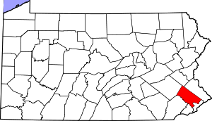
Delaware County, colloquially referred to as Delco, is a county in the Commonwealth of Pennsylvania. With a population of 576,830 as of the 2020 census, it is the fifth-most populous county in Pennsylvania and the third-smallest in area. The county was created on September 26, 1789, from part of Chester County and named for the Delaware River. The county is part of the Southeast Pennsylvania region of the state.

<span class="mw-page-title-main">Limerick Township, Pennsylvania</span> Township in Pennsylvania, United States

Limerick Township is a township in Montgomery County, Pennsylvania, United States.

<span class="mw-page-title-main">Lower Gwynedd Township, Pennsylvania</span> Township in Pennsylvania, United States

Lower Gwynedd Township is a township and equestrian community in Montgomery County, Pennsylvania, United States. The population was 11,405 at the 2010 census. The township comprises four villages: Gwynedd, Gwynedd Valley, Penllyn, and Spring House. The township is considered a haven for those seeking a country lifestyle, while still being in close proximity to nearby towns and Center City Philadelphia. While its postal address is in Ambler, Pennsylvania (19002), it is not associated with the Borough of Ambler.

<span class="mw-page-title-main">Lower Pottsgrove Township, Pennsylvania</span> Township in Pennsylvania, United States

Lower Pottsgrove Township is a township in Montgomery County, Pennsylvania, United States, approximately 30 miles northwest of Philadelphia and 18 miles southeast of Reading, along the Schuylkill River. The population was 12,059 at the 2010 census.

<span class="mw-page-title-main">Lower Providence Township, Pennsylvania</span> Township in Pennsylvania, United States

Lower Providence Township is a township in Montgomery County, Pennsylvania, United States. The township is located approximately 17 miles northwest of Philadelphia. The population was 25,625 at the 2020 census.

<span class="mw-page-title-main">Montgomery Township, Montgomery County, Pennsylvania</span> Township in Pennsylvania, United States

Montgomery Township is a township in Montgomery County, Pennsylvania. It is the location of the Montgomery Mall, a regional shopping mall serving the Route 309 corridor of the Philadelphia suburbs. Much of Montgomery Township's development is suburban in character, with newer tract houses and strip shopping centers. Homes in Montgomery Township have North Wales and Lansdale addresses, but businesses that are located within the township boundaries are given the Montgomeryville ZIP Code. The township is in the North Penn School District and is part of the North Penn Valley region that is centered around the borough of Lansdale.

<span class="mw-page-title-main">New Hanover Township, Pennsylvania</span> Township in Pennsylvania, United States

New Hanover Township is a township in Montgomery County, Pennsylvania, United States. The population was 10,939 at the 2010 census.

<span class="mw-page-title-main">Pottstown, Pennsylvania</span> Borough in Pennsylvania, United States

Pottstown is a borough in Montgomery County, Pennsylvania, United States. Pottstown was laid out in 1752–53 and named Pottsgrove in honor of its founder, John Potts. The old name was abandoned at the time of the incorporation as a borough in 1815. In 1888, the limits of the borough were considerably extended. Pottstown is the center of a productive farming and dairying region.

<span class="mw-page-title-main">Upper Dublin Township, Pennsylvania</span> Township in Pennsylvania, United States

Upper Dublin Township is a township in Montgomery County, Pennsylvania, United States. The population was 25,569 at the 2010 census. Until the 1950s, Upper Dublin was mostly farmland and open space, but transitioned to a residential suburb during the postwar population boom. The population went from just over 6,000 residents in the 1950s to just under 20,000 by 1970. Today, Upper Dublin is mostly spread-out development housing, and has the fourth highest median income in Montgomery County.

<span class="mw-page-title-main">Upper Gwynedd Township, Pennsylvania</span> Township in Pennsylvania, United States

Upper Gwynedd Township is a township in Montgomery County, Pennsylvania, United States. The population was 15,552 at the time of the 2010 census. North Wales Borough is surrounded by Upper Gwynedd Township on all sides, and many homes and businesses with North Wales addresses are actually in Upper Gwynedd. Many properties with Lansdale addresses are in Upper Gwynedd as well. It is part of the North Penn Valley region that is centered around the borough of Lansdale.

<span class="mw-page-title-main">Upper Pottsgrove Township, Pennsylvania</span> Township in Pennsylvania, United States

Upper Pottsgrove Township is a township in Montgomery County, Pennsylvania, United States. The population was 5,315 at the 2010 census.

<span class="mw-page-title-main">Upper Providence Township, Montgomery County, Pennsylvania</span> Township in Pennsylvania, United States

Upper Providence Township is a township in Montgomery County, Pennsylvania, United States. As of the 2010 census, the township population was 21,219.

<span class="mw-page-title-main">Delaware Valley</span> Metropolitan area in the United States

The Delaware Valley, sometimes referred to as Greater Philadelphia or the Philadelphia metropolitan area, is a metropolitan region in the Northeast United States that centers around Philadelphia, the nation's sixth-most populous city, and spans parts of four U.S. states: southeastern Pennsylvania, southern New Jersey, northern Delaware, and the northern Eastern Shore of Maryland. With a core metropolitan statistical area population of 6.288 million residents and a combined statistical area population of 7.366 million as of the 2020 census, the Delaware Valley is the eighth-largest metropolitan region in the nation and North America, and the 68th-largest metropolitan region in the world.

<span class="mw-page-title-main">Cradle of Liberty Council</span> Boy Scouts of America council

The Cradle of Liberty Council (#525) is a Boy Scouts of America council created in 1996 with the merger of the former Philadelphia Council and the former Valley Forge Council.

The Association of Delaware Valley Independent Schools (ADVIS) is a voluntary, non-profit consortium of independent schools in the Delaware Valley area of the United States. With headquarters in Bryn Mawr, Pennsylvania, the Association currently has 134 members located throughout eastern Pennsylvania, northern Delaware, and central and southern New Jersey.

<span class="mw-page-title-main">Jon D. Fox</span> American politician

Jon D. Fox was an American Republican politician. He served as a member of Pennsylvania House of Representatives from 1985 to 1992 before being elected to the Montgomery County Board of Commissioners (1992-1995). His final political role was as a member of the U.S. House of Representatives from Pennsylvania between 1995 and 1999.

<span class="mw-page-title-main">Huntingdon Valley, Pennsylvania</span> Village in Pennsylvania, United States

Huntingdon Valley is a village, as well as a suburban mailing address located in Lower Moreland Township, Upper Moreland Township and Abington Township all in Montgomery County, and in small sections of Upper Southampton Township and Lower Southampton Township in Bucks County, Pennsylvania, United States, bordering the Fox Chase, Bustleton, and Somerton sections of Philadelphia.

Pennsylvania State Senate District 24 includes parts of Berks County and Montgomery County. It is currently represented by Republican Tracy Pennycuick.

<span class="mw-page-title-main">Pennypack Trail</span> Multi-use trail in Southeast Pennsylvania

The Pennypack Trail is a rail trail located in eastern Montgomery County, Pennsylvania in the United States. The trail runs 6.2 miles (10.0 km) from Rockledge north to the County Line Road border with Bucks County in Huntingdon Valley along the former alignment of SEPTA's Fox Chase-Newtown Line. The trail is maintained by the Montgomery County Division of Parks, Trails, & Historic Sites.

References

  1. Includes Philadelphia, Montgomery, Bucks, Delaware, Chester, Lehigh and Northampton Counties
  1. 1 2
    • "Amos Lee Performs, Montco Train Derailment, The First Lady of World War II". WHYY. Retrieved July 20, 2023.
    • "NEXT Weather: Tornado warnings expire for Philadelphia, MontCo". CBS News Philadelphia. July 16, 2023. Retrieved July 20, 2023.
    • Stamm, Dan (July 18, 2023). "Pa. Turnpike in Montco was closed for hours Tuesday morning". NBC10 Philadelphia. Retrieved July 20, 2023.
  2. 1 2 "State & County QuickFacts". United States Census Bureau . Retrieved July 5, 2022.
  3. "Find a County". National Association of Counties. Archived from the original on May 31, 2011. Retrieved June 7, 2011.
  4. "Montgomery County, Pennsylvania". Family Search. Retrieved January 21, 2015.
  5. "2010 Census Gazetteer Files". United States Census Bureau. August 22, 2012. Retrieved March 9, 2015.
  6. "2023 Proposed Operating Budget".
  7. "Annual Estimates of the Resident Population for Counties: April 1, 2020 to July 1, 2021" . Retrieved July 5, 2022.
  8. "U.S. Decennial Census". United States Census Bureau. Retrieved March 9, 2015.
  9. "Historical Census Browser". University of Virginia Library. Retrieved March 9, 2015.
  10. Forstall, Richard L., ed. (March 24, 1995). "Population of Counties by Decennial Census: 1900 to 1990". United States Census Bureau. Retrieved March 9, 2015.
  11. "Census 2000 PHC-T-4. Ranking Tables for Counties: 1990 and 2000" (PDF). United States Census Bureau. April 2, 2001. Retrieved March 9, 2015.
  12. "Explore Census Data".
  13. "P2 HISPANIC OR LATINO, AND NOT HISPANIC OR LATINO BY RACE – 2020: DEC Redistricting Data (PL 94-171) – Montgomery County, Pennsylvania".
  14. "Montgomery County," Rydal-Meadowbrook Civic Association Archived October 13, 2013, at the Wayback Machine
  15. "Moody's downgrades Montgomery County's (PA) general obligation rating to Aa1 from Aaa; outlook is stable". Moodys.com. July 19, 2012. Retrieved May 28, 2018.
  16. "Montgomery County, PA". Montgomery County, PA. Retrieved May 28, 2018.
  17. Top 50 Employers by County – Montgomery Archived October 14, 2013, at the Wayback Machine
  18. "2020 CENSUS - SCHOOL DISTRICT REFERENCE MAP: Montgomery County, PA" (PDF). U.S. Census Bureau . Retrieved July 20, 2022. - Text list
  19. Meetings & Notices Archived July 23, 2007, at the Wayback Machine
  20. Upper Frederick Township, Pennsylvania
  21. "Decennial Census by Decades". www.census.gov. Retrieved November 29, 2018.
  22. "Welcome Aboard!". Pottstown Area Rapid Transit. Retrieved March 22, 2023.
  23. "About Us | PHL.org". www.phl.org. Retrieved March 22, 2023.
  24. 1 2 "PRISM Climate Group, Oregon State University" . Retrieved August 9, 2019.
  25. Pennsylvania Department of State, Voting and Election Statistics, accessed December 27, 2022
  26. "Montgomery County Election Results". electionresults.montcopa.org. Archived from the original on November 7, 2016. Retrieved November 25, 2016.
  27. Leip, David. "Dave Leip's Atlas of U.S. Presidential Elections". uselectionatlas.org. Retrieved November 29, 2018.
  28. "Pennsylvania Gay Marriage Law Deemed 'Suspect' By County Official". The Huffington Post. August 19, 2013. Retrieved August 26, 2013.
  29. "Montgomery County still unable to issue same-sex marriage licenses". The Times Herald. May 21, 2014. Retrieved January 24, 2018.

40°13′N75°22′W / 40.21°N 75.37°W / 40.21; -75.37