Skippack, Pennsylvania

Last updated

Skippack
Schippach
originally named "Van Bebber's Township"
Skippack Village.jpg
USA Pennsylvania location map.svg
Red pog.svg
Skippack
Location of Skippack in Pennsylvania
Coordinates: 40°13′37″N75°23′56″W / 40.22694°N 75.39889°W / 40.22694; -75.39889
CountryUnited States
StatePennsylvania
County Montgomery
Township Skippack
Area
  Total2.6 sq mi (7 km2)
  Land2.5 sq mi (6 km2)
  Water0.1 sq mi (0.3 km2)
Elevation
184 ft (56 m)
Population
 (2010)
  Total3,758
  Density1,400/sq mi (560/km2)
Time zone UTC-5 (EST)
  Summer (DST) UTC-4 (EDT)
ZIP Code
19474
Area code(s) 610 and 484

Skippack (Pennsylvania German: Schippach), originally named "Van Bebber's Township", is a census-designated place (CDP) in Skippack Township, Montgomery County, Pennsylvania, United States. The population was 3,758 at the 2010 census.

Contents

History

In 1683, the Original 13, thirteen families from the lower Rhine River arrived at Philadelphia aboard the Concord, on October 6 of that year. These families were primarily linen weavers, but also knew how to farm. These first German immigrants left their homeland of Germany because of persecution they experienced as religious Anabaptist Mennonite and Quakers from the Catholic, Lutheran and Reformed Churches. Upon arriving at Philadelphia, the families were greeted by the representative of the Frankfort Land Company, a highly educated German lawyer, Franz Daniel Pastorius, who charged with the authority to make land transactions with the thirteen families. After inspecting different areas of the vicinity of Philadelphia, the families settled on the land that was to become the villages of Germantown, Summerhousen, Crefeld, and Germantownship.

Within approximately twenty years Anabaptist German farmers in the Electorate of the Palatinate began to immigrate to Philadelphia in such numbers that Benjamin Franklin wrote an editorial fearing that Pennsylvania would soon become a majority German-speaking colony. As the Germantown area became more densely settled, there was a departure of some of the original families of Germantown to an area twenty miles west of Philadelphia further up the Schuylkill, purchasing land from the father in-law of Herman Isacks op den Graeff (an original settler of Germantown), who had earlier purchased approximately seven thousand acres. These German Mennonites brought the linen making business to the community, along with their farming skills. They settled on farms in the vicinity of Perkiomen Creek and Skippack Creek, up to a point where travel by boat became impossible because of shallow water. This point is where Skippack Creek crosses Skippack Pike in Skippack Township. The origin of the name "Skippack" came from early German settlers, they originally spelled it Schippach, named after a town of the same name in Bavaria.

Skippack Township was originally named "Van Bebber's Township" after Matthias van Bebber, to whom the original land patent was issued in 1702 by William Penn, the founder of Pennsylvania. The name later changed to "Skippack and Perkiomen Township" until the township was split into two townships. Skippack Township is home to one of the oldest homes still standing in the area, the Indenhofen (De Haven) Farmstead, built in circa 1720. It was listed on the National Register of Historic Places in 1973, as the Warren Z. Cole House. [1] Originally, the Indenhofen Farm consisted of 440 acres (1.8 km2).

In 1795, Jacob Reiff bought a property at Store Road and Skippack Pike and opened a general merchandise store.Skippack Historical Society, Montgomery County, Pennsylvania In 1800, the store was sold to Jacob Sorver, who ran it until 1854. A post office was established in 1827 with weekly mail delivery by the Kutztown stagecoach.

The Souderton, Skippack & Fairview Electric Railway Co. was formed in 1901 to provide trolley service from Norristown, through Trooper and Worcester to Souderton. Trolley service to Skippack began in 1908. Harleysville was reached in 1912; the line to Souderton was never completed. The railway was renamed the Montgomery County Rapid Transit Company and later the Montgomery Transit Company. In 1923, its name was changed once again to the Skippack & Perkiomen Transit Company. The "Wogglebug" trolleys ran on the south shoulder of Skippack Pike through the village (a sidewalk was on the north side). Buses replaced the trolleys in 1925. In 1940 the bus service ended.

Geography

Skippack is located at 40°13′37″N75°23′56″W / 40.22694°N 75.39889°W / 40.22694; -75.39889 (40.227014, -75.398889). [2]

According to the United States Census Bureau, the CDP has a total area of 2.6 square miles (6.7 km2), of which 2.5 square miles (6.5 km2) is land and 0.39% is water.

Skippack is a historic shopping village which lies within the boundaries of Skippack Township. Once termed Skippackville, the village served residents of Skippack with a post office, fire house, printing house, shirt factory, furniture maker, blacksmith, liquor store, a hat store and several inns including the Valley House now called "Justin's Carriage House". The village has recently seen an influx of unique restaurants and boutiques.

Creamery Village is located within Skippack Township and is partially within the CDP of Skippack. Creamery has its own post office for residents in the adjoining area. The original general store is still standing but today functions as one of the many "antique" dealers in Montgomery County. (The store was torn down in the spring of 2015 due to a fire in the winter of 2013)

Demographics

Historical population
CensusPop.Note
1990 8,790
2000 6,516−25.9%
2010 3,758−42.3%

As of the 2010 census, the CDP was 89.6% Non-Hispanic White, 2.0% Black or African American, 5.1% Asian, 0.9% were Some Other Race, and 1.2% were two or more races. 2.2% of the population were of Hispanic or Latino ancestry. [3]

As of the census [4] of 2000, there were 2,889 people, 1,109 households, and 829 families residing in the CDP. The population density was 1,134.0 inhabitants per square mile (437.8/km2). There were 1,152 housing units at an average density of 452.2 per square mile (174.6/km2). The racial makeup of the CDP was 96.71% White, 1.00% African American, 0.45% Native American, 1.07% Asian, 0.21% from other races, and 0.55% from two or more races. Hispanic or Latino of any race were 1.32% of the population.

There were 1,109 households, out of which 35.9% had children under the age of 18 living with them, 64.9% were married couples living together, 7.7% had a female householder with no husband present, and 25.2% were non-families. 19.8% of all households were made up of individuals, and 3.6% had someone living alone who was 65 years of age or older. The average household size was 2.61 and the average family size was 3.03.

In the CDP, the population was spread out, with 25.9% under the age of 18, 4.6% from 18 to 24, 38.8% from 25 to 44, 22.5% from 45 to 64, and 8.2% who were 65 years of age or older. The median age was 35 years. For every 100 females, there were 93.5 males. For every 100 females age 18 and over, there were 91.3 males.

The median income for a household in the CDP was $66,486, and the median income for a family was $73,871. Males had a median income of $51,315 versus $40,179 for females. The per capita income for the CDP was $31,185. None of the families and 1.1% of the population were living below the poverty line, including no under eighteens and none of those over 64.

Industry and attractions

The primary industry of Skippack village is tourism. During the week and on weekends the streets of Skippack are crowded with local residents and tourists visiting the many unique shops and restaurants, antique shops, art galleries, or just strolling along the village sidewalks. The town also offers year-round events and free concerts. A community theater, Playcrafters of Skippack, features productions year round. Here's an updated Skippack Events listing.

Local merchants and restaurants throughout Skippack have joined forces to create Skippack First Fridays to encourage the public to re-discover the Village of Skippack and its hidden gems. The event is held every First Friday for the months of April through October from 5-9 p.m., as well as at various locations throughout the year. Activities include live music, exhibiting artists and entertainment for the whole family.

Notable person

Related Research Articles

<span class="mw-page-title-main">Montgomery County, Pennsylvania</span> County in Pennsylvania, United States

Montgomery County, colloquially referred to as Montco, is a county in the Commonwealth of Pennsylvania. As of the 2020 census, the population of the county was 856,553, making it the third-most populous county in Pennsylvania after Philadelphia and Allegheny counties.

<span class="mw-page-title-main">Audubon, Pennsylvania</span> Census-designated place in Pennsylvania, United States

Audubon is a census-designated place (CDP) in Lower Providence Township, Montgomery County, Pennsylvania, United States. It was named for naturalist John James Audubon, who lived there as a young man. The population was 8,433 at the 2010 census.

<span class="mw-page-title-main">Collegeville, Pennsylvania</span> Borough in Pennsylvania, United States

Collegeville is a borough in Montgomery County, Pennsylvania, a suburb outside of Philadelphia on Perkiomen Creek. Collegeville was incorporated in 1896. It is the location of Ursinus College, which opened in 1869. The population was 5,089 at the 2010 census.

<span class="mw-page-title-main">Franconia Township, Pennsylvania</span> Township in Pennsylvania, United States

Franconia Township is a township in Montgomery County, Pennsylvania, United States. The population was 13,064 at the 2010 census.

<span class="mw-page-title-main">Glenside, Pennsylvania</span> Place in Pennsylvania, United States

Glenside is a census-designated place (CDP) located in Cheltenham Township and Abington Township in Montgomery County, Pennsylvania, United States. It borders Northwest Philadelphia. The population was 7,737 at the 2020 census on a land area of 1.3 square miles.

<span class="mw-page-title-main">Harleysville, Pennsylvania</span> Census-designated place in Pennsylvania, United States

Harleysville is a census-designated place (CDP) in Montgomery County, Pennsylvania, United States. It is a suburb of Philadelphia. The population was 9,286 at the 2010 census. It is located mostly within Lower Salford Township and also in Franconia Township. Harleysville was settled by Pennsylvania Dutch in the 18th century and was named after Samuel Harley.

<span class="mw-page-title-main">Lower Frederick Township, Pennsylvania</span> Township in Pennsylvania, United States

Lower Frederick Township is a township in Montgomery County, Pennsylvania, United States. The population was 4,840 at the 2010 census.

<span class="mw-page-title-main">Lower Providence Township, Pennsylvania</span> Township in Pennsylvania, United States

Lower Providence Township is a township in Montgomery County, Pennsylvania, United States. The township is located approximately 17 miles northwest of Philadelphia. The population was 25,625 at the 2020 census.

<span class="mw-page-title-main">Lower Salford Township, Pennsylvania</span> Township in Pennsylvania, United States

Lower Salford is a township in Montgomery County, Pennsylvania. It is located one mile west of the Lansdale exit of the Pennsylvania Turnpike. It is centered on the intersection of Route 63, and Route 113.

<span class="mw-page-title-main">Perkiomen Township, Pennsylvania</span> Township in the U.S. state of Pennsylvania

Perkiomen Township is a township in Montgomery County, Pennsylvania, United States. As of the 2010 census, the township population was 9,139, which represents a 28.8% increase from the 2000 total of 7,093 residents. Governmentally, it is a township of the second class, governed by a board of supervisors. It is part of the Perkiomen Valley School District. Perkiomen Township includes an abundance of history that goes as far back as to the first tribes who inhabited the area. This township started with the inhabitants of the Lenni-Lenape Tribe and progressed in many ways into what it is today.

<span class="mw-page-title-main">Plymouth Meeting, Pennsylvania</span> Census-designated place in Pennsylvania, United States

Plymouth Meeting is a census-designated place (CDP) that straddles Plymouth and Whitemarsh Townships in Montgomery County, Pennsylvania, United States. The settlement was founded in 1686.

<span class="mw-page-title-main">Skippack Township, Pennsylvania</span> Township in Pennsylvania, United States

Skippack Township is a township in Montgomery County, Pennsylvania, United States. The population was 14,408 in 2022 according to the Census Bureau. This represents a 5.1% increase from the 2010 Census.

<span class="mw-page-title-main">Upper Providence Township, Montgomery County, Pennsylvania</span> Township in Pennsylvania, United States

Upper Providence Township is a township in Montgomery County, Pennsylvania, United States. As of the 2010 census, the township population was 21,219.

<span class="mw-page-title-main">Upper Salford Township, Pennsylvania</span> Township in Pennsylvania, United States

Upper Salford Township is a township in Montgomery County, Pennsylvania, United States. The population was 3,299 at the 2010 census.

<span class="mw-page-title-main">Whitemarsh Township, Pennsylvania</span> Home rule municipality in Pennsylvania, United States

Whitemarsh Township is a Home rule municipality in Montgomery County, Pennsylvania. It retains its former classification of "Township" in its official name despite being a home rule municipality. The population was 17,349 at the 2010 census. Whitemarsh is adjacent to the neighborhood of Andorra in the Roxborough section of Philadelphia, and is bordered in Montgomery County by Springfield, Upper Dublin, Whitpain, and Plymouth townships, Conshohocken, and the Schuylkill River, which separates it from Lower Merion Township.

<span class="mw-page-title-main">Worcester Township, Pennsylvania</span> Township in Pennsylvania, United States

Worcester Township is a township in Montgomery County, Pennsylvania, United States. The population was 9,750 at the 2010 census. It is pronounced as 'WOR-ses-ter.'

<span class="mw-page-title-main">Beggarstown</span> Former community in the USA

Beggarstown or Bettelhausen was a small community that was located in the present day neighborhood of Mount Airy in Northwest Philadelphia in the U.S. state of Pennsylvania. It centered primarily along a stretch of relatively flat land along Germantown Avenue roughly between Upsal Street and Gorgas Lane.

<span class="mw-page-title-main">Evansburg Historic District</span> Historic district in Pennsylvania, United States

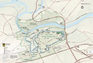
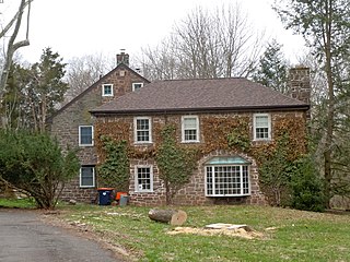
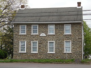
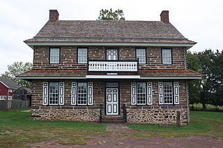
The Evansburg Historic District in Evansburg, Pennsylvania, United States, is a National Historic District designated by Congress with over 50 National Register properties dating from the early 18th through 19th century. Almost all of these properties are privately owned and in active use at this time. The Evansburg Historic District was listed on the National Register of Historic Places in 1972.

<span class="mw-page-title-main">Woxall, Pennsylvania</span> Village in Pennsylvania, United States

Woxall or sometimes Woxhall is a census-designated place (CDP) in Upper Salford Township, Montgomery County, Pennsylvania, United States. It is located on the eastern side of the Perkiomen Creek, which flows south into the Schuylkill River. The population was 1,318 at the 2010 census. The CDP is served by the Harleysville post office, with the zip code of 19438.

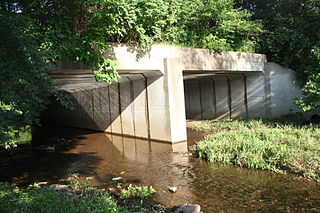
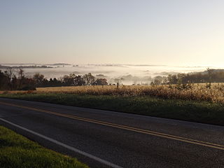
Germantown Pike is a historic road in Pennsylvania that opened in 1687, running from Philadelphia northwest to Collegeville. The road is particularly notable for the "imposing mansions" that existed in the Germantown neighborhood in Philadelphia. The road was left in ruins after the British destroyed it in the Revolutionary War during the 1777 Battle of Germantown, and was not rebuilt until 1809. Portions of Germantown Pike were signed as U.S. Route 422 (US 422) before the latter was rerouted along a freeway alignment to King of Prussia.

References

  1. "National Register Information System". National Register of Historic Places . National Park Service. July 9, 2010.
  2. "US Gazetteer files: 2010, 2000, and 1990". United States Census Bureau. February 12, 2011. Retrieved April 23, 2011.
  3. Census 2010: Pennsylvania. Usatoday.Com. Retrieved on 2013-07-21.
  4. "U.S. Census website". United States Census Bureau . Retrieved January 31, 2008.