Schwenksville, Pennsylvania

Last updated
Borough of Schwenksville
Main Street, Schwenksville, PA.JPG
Main Street in Schwenksville in November 2012
Schwenksville Montgomery County.png
Location of Schwenksville in Montgomery County, Pennsylvania
USA Pennsylvania location map.svg
Red pog.svg
Schwenksville
Location of Schwenksville in Pennsylvania
Usa edcp location map.svg
Red pog.svg
Schwenksville
Schwenksville (the United States)
Coordinates: 40°15′23″N75°27′54″W / 40.25639°N 75.46500°W / 40.25639; -75.46500
CountryUnited States
StatePennsylvania
County Montgomery
Government
  TypeCouncil-manager
  MayorChristian Caiola
  Borough ManagerAnne Klepfer
Area
[1]
  Total0.40 sq mi (1.04 km2)
  Land0.40 sq mi (1.04 km2)
  Water0.00 sq mi (0.01 km2)
Elevation
213 ft (65 m)
Population
 (2020) [2]
  Total1,296
  Density3,240.00/sq mi (1,250.23/km2)
Time zone UTC-5 (EST)
  Summer (DST) UTC-4 (EDT)
ZIP Code
19473
Area code(s) 610 and 484
FIPS code 42-68328

Schwenksville is a borough in Montgomery County, Pennsylvania, United States. The population was 1,431 at the 2020 census. It is notable for being located near the site of the Philadelphia Folk Festival. The borough was founded in 1684, when the Lenni-Lenape Indians ceded to William Penn the land along the Perkiomen Creek; it was incorporated in 1903. The borough was named for George Schwenk, whose son, Jacob Schwenk, served in George Washington's army.

Contents

The town was the inspiration for the protagonist in Catherine Gilbert Murdock's 2006 novel Dairy Queen . [3]

The Hall & Oates song "Perkiomen" was written about the Perkiomen Creek, which constitutes Schwenksville's eastern border. "Perkiomen" is Lenape for "muddy waters" and "where the cranberries grow."

Schwenksville is also the gateway to the Perkiomen Trail, a nineteen-mile section of the former Reading Railroad's Perkiomen Valley corridor. It now serves as a multi-use rail trail and was completed in 2003.

Geography

Schwenksville is located at 40°15′23″N75°27′54″W / 40.25639°N 75.46500°W / 40.25639; -75.46500 (40.256418, -75.465012). [4]

According to the U.S. Census Bureau, the borough has a total area of 0.4 square miles (1.0 km2), 0.4 square miles (1.0 km2) of which is land and 2.38% of which is water.

Climate

The climate in this area is characterized by hot, humid summers and generally mild to cool winters. According to the Köppen Climate Classification system, Schwenksville has a humid subtropical climate, abbreviated "Cfa" on climate maps. [5]

History

General George Washington and the Continental Army camped in and around Schwenksville September 26 to 29 and October 4 to 8, 1777 prior to and immediately following the October 4 Battle of Germantown. Washington's headquarters probably was at the Henry Kelly House (demolished), just southwest of the town that he called "Pawling's Mill." [6] The bulk of the Army camped on the opposite side of the Perkiomen Creek, at Pennypacker Mills.

The borough was originally part of Perkiomen Township and home to the first copper mine in Pennsylvania. Ice harvesting was a major industry in the area. Several large icehouses were located along the creek, and ice was regularly shipped to Philadelphia. Mills devoted to grain and textiles were also very prominent which is evident by the existing historic structures. Its location along the Perkiomen Creek made the Borough a great summer resort community during its early existence, and Schwenksville was once home to The Perkiomen Inn, Spring Mountain House, and The Woodside Inn.

It was home to the Schwenksville Union School District until amalgamation with the Perkiomen Joint School District to form Perkiomen Valley School District in 1969.

Today the Borough is a residential community. Commercial and industrial businesses are located along the Main Street corridor. Schwenksville Elementary School; the Perkiomen Valley Branch of the Montgomery County-Norristown Public Library; the Schwenksville post office; two banks; three churches - Heidelberg United Church of Christ, Jerusalem Lutheran, and Eden Mennonite; and a 6.47-acre park along the Perkiomen Creek are located within the borough.

The Pennypacker Mansion and Sunrise Mill are listed on the National Register of Historic Places. [7]

Demographics

Historical population
CensusPop.Note
1880 303
1910 381
1920 337−11.5%
1930 40520.2%
1940 48319.3%
1950 56316.6%
1960 62010.1%
1970 80930.5%
1980 1,04128.7%
1990 1,32627.4%
2000 1,69327.7%
2010 1,385−18.2%
2020 1,296−6.4%
U.S. Decennial Census [8]

As of the 2020 census, the borough was 86.2% White, 9.22% Black or African American, 0.84% Asian, and 1.47% were two or more races. 2.31% of the population were of Hispanic or Latino ancestry .

There were 626 households, out of which 25.9% had children under the age of 18 living with them, 38.0% were married couples living together, 9.7% had a female householder with no husband present, and 47.8% were non-families. 40.1% of all households were made up of individuals, and 18.4% had someone living alone who was 65 years of age or older. The average household size was 2.13 and the average family size was 2.91.

In 2000, 17.7% of the population under the age of 18, with 26.5% from 18 to 24, 27.5% from 25 to 44, 15.2% from 45 to 64, and 13.1% who were 65 years of age or older. The median age was 30 years. For every 100 females there were 88.3 males. For every 100 females age 18 and over, there were 85.2 males.

The median income for a household in the borough was $44,514, and the median income for a family was $55,000. Males had a median income of $37,566 versus $31,200 for females. The per capita income for the borough was $19,679. About 3.3% of families and 5.4% of the population were below the poverty line, including 6.9% of those under age 18 and 12.2% of those age 65 or over.

Politics and government

Presidential elections results [9]
Year Republican Democratic
2020 44.9% 29752.6%348
2016 46.7%26646.3% 264
2012 45.4% 25151.9%287
2008 39.2% 22059.5%334
2004 50.7%30248.2% 287
2000 50.2%22245.5% 201

Schwenksville has a city manager form of government with a mayor and a five-member borough council. In 2007, Democrats took control of the borough council for the first time in the borough's history. Currently, Council consists of 3 Democrats, 1 Republican, and 1 Independent.

The borough also has active Activity and Historical Committees. The goal of the Activity Committee is to plan and support various community activities to promote a sense of vitality in the community. Accordingly, Community Day was started in 2009 to promote the businesses and non-profit organizations in Schwenksville with a fun community event. Committee members may plan other events through the year as well. The Historic Committee was formed by the borough for the purpose of exploring ways to save meaningful older buildings from being destroyed and to keep the rich history of Schwenksville intact for future generations.

The borough is part of the Fourth Congressional District (represented by Rep. Madeleine Dean), Pennsylvania's 147th Representative District (represented by Rep. Matt Bradford) and the 24th State Senate District (represented by Sen. Tracy Pennycuick).

It is home to Meadow Park, which has a pavilion and provides a relaxing spot for people to walk and fish in the Creek. The borough intends to further develop the Park by adding a walking path and other activities as our funding and grant funding allow. The Perkiomen Trail also runs through the Schwenksville borough, providing access to recreational activities along the trail.

Transportation

PA 29 and PA 73 in Schwenksville 2022-10-26 16 33 59 View north along Pennsylvania State Route 29 and west along Pennsylvania State Route 73 (Main Street) just northwest of Skippack Pike in Schwenksville, Montgomery County, Pennsylvania.jpg
PA 29 and PA 73 in Schwenksville

As of 2020 there were 4.04 miles (6.50 km) of public roads in Schwenksville, of which 1.24 miles (2.00 km) were maintained by the Pennsylvania Department of Transportation (PennDOT) and 2.80 miles (4.51 km) were maintained by the borough. [10]

Pennsylvania Route 29 and Pennsylvania Route 73 traverse the borough concurrently. The two routes follow Main Street on a general north-south alignment through the borough.

Education

Schwenksville is part of the Perkiomen Valley School District.

Residents are zoned to Schwenksville Elementary School, [11] Middle School West, [12] and Perkiomen Valley High School.

See also

Related Research Articles

<span class="mw-page-title-main">Birdsboro, Pennsylvania</span> Borough in Pennsylvania, United States

Birdsboro is a borough in Berks County, Pennsylvania, United States. It is located along the Schuylkill River 8 miles (13 km) southeast of Reading. As of the 2010 census, it had a population of 5,163. Birdsboro's economy had historically been rooted in large foundries and machine shops, none of which remain in operation today.

<span class="mw-page-title-main">Hereford Township, Pennsylvania</span> Township in Pennsylvania, United States

Hereford Township is a township in Berks County, Pennsylvania, United States. It is the easternmost municipality within Berks County. Its population was 2,969 at the 2020 census. It is in Upper Perkiomen School District.

<span class="mw-page-title-main">Hilltown Township, Pennsylvania</span> Township in Pennsylvania, United States

Hilltown Township is a township in Bucks County, Pennsylvania, United States. The population was 15,029 at the 2010 census. Most of Hilltown is part of Pennridge School District, while a small portion in Line Lexington is part of North Penn School District.

<span class="mw-page-title-main">West Rockhill Township, Pennsylvania</span> Township in Pennsylvania, United States

West Rockhill Township is a township in Bucks County, Pennsylvania, United States. The original Rockhill Township was established in 1740 and was divided into East Rockhill and West Rockhill Townships in 1890. The population was 5,256 at the 2010 census. West Rockhill Township is part of Pennridge School District.

<span class="mw-page-title-main">Audubon, Pennsylvania</span> Census-designated place in Pennsylvania, United States

Audubon is a census-designated place (CDP) in Lower Providence Township, Montgomery County, Pennsylvania, United States. It was named for naturalist John James Audubon, who lived there as a young man. The population was 8,433 at the 2010 census.

<span class="mw-page-title-main">Collegeville, Pennsylvania</span> Borough in Pennsylvania, United States

Collegeville is a borough in Montgomery County, Pennsylvania, a suburb outside of Philadelphia on Perkiomen Creek. Collegeville was incorporated in 1896. It is the location of Ursinus College, which opened in 1869. The population was 5,089 at the 2010 census.

<span class="mw-page-title-main">Conshohocken, Pennsylvania</span> Borough in Pennsylvania, United States

Conshohocken is a borough on the Schuylkill River in Montgomery County, Pennsylvania in suburban Philadelphia. Historically a large mill town and industrial and manufacturing center, after the decline of industry in recent years Conshohocken has developed into a center of riverfront commercial and residential development. In the regional slang, it is sometimes referred to by the colloquial nickname Conshy.

<span class="mw-page-title-main">East Greenville, Pennsylvania</span> Borough in Pennsylvania, United States

East Greenville is a borough in Montgomery County, Pennsylvania. The population was 2,951 at the 2010 census. It is one of a strip of small towns that run together along Route 29, including Red Hill, Pennsburg, and East Greenville. The borough is part of the Upper Perkiomen School District.

<span class="mw-page-title-main">Green Lane, Pennsylvania</span> Borough in Pennsylvania, United States

Green Lane is a borough in Montgomery County, Pennsylvania. The population was 490 at the 2020 census. It is part of the Upper Perkiomen School District and Boyertown Area School District.

<span class="mw-page-title-main">Harleysville, Pennsylvania</span> Census-designated place in Pennsylvania, United States

Harleysville is a census-designated place (CDP) in Montgomery County, Pennsylvania, United States. It is a suburb of Philadelphia. The population was 9,286 at the 2010 census. It is located mostly within Lower Salford Township and also in Franconia Township. Harleysville was settled by Pennsylvania Dutch in the 18th century and was named after Samuel Harley.

<span class="mw-page-title-main">Lower Frederick Township, Pennsylvania</span> Township in Pennsylvania, United States

Lower Frederick Township is a township in Montgomery County, Pennsylvania, United States. The population was 4,840 at the 2010 census.

<span class="mw-page-title-main">Lower Providence Township, Pennsylvania</span> Township in Pennsylvania, United States

Lower Providence Township is a township in Montgomery County, Pennsylvania, United States. The township is located approximately 17 miles northwest of Philadelphia. The population was 25,625 at the 2020 census.

<span class="mw-page-title-main">Pennsburg, Pennsylvania</span> Borough in Pennsylvania, United States

Pennsburg is a borough in Montgomery County, Pennsylvania. Its population was 3,889 at the 2020 census. It is part of the Upper Perkiomen School District. It is also part of the strip of small towns that run together along Route 29: Red Hill, Pennsburg, and East Greenville. The towns are collectively referred to as Upper Perk.

<span class="mw-page-title-main">Perkiomen Township, Pennsylvania</span> Township in the U.S. state of Pennsylvania

Perkiomen Township is a township in Montgomery County, Pennsylvania, United States. As of the 2010 census, the township population was 9,139, which represents a 28.8% increase from the 2000 total of 7,093 residents. Governmentally, it is a township of the second class, governed by a board of supervisors. It is part of the Perkiomen Valley School District. Perkiomen Township includes an abundance of history that goes as far back as to the first tribes who inhabited the area. This township started with the inhabitants of the Lenni-Lenape Tribe and progressed in many ways into what it is today.

<span class="mw-page-title-main">Red Hill, Pennsylvania</span> Borough in Pennsylvania, United States

Red Hill is a borough in Montgomery County, Pennsylvania, United States. It is primarily a lakeshore, lowlands, suburban community northwest of Philadelphia in the Delaware River Valley watershed, as is the balance of its county. Its population was 2,383 at the 2010 census.

<span class="mw-page-title-main">Skippack Township, Pennsylvania</span> Township in Pennsylvania, United States

Skippack Township is a township in Montgomery County, Pennsylvania, United States. The population was 14,408 in 2022 according to the Census Bureau. This represents a 5.1% increase from the 2010 Census.

<span class="mw-page-title-main">Trappe, Pennsylvania</span> Borough in Pennsylvania, United States

Trappe is a borough in Montgomery County, Pennsylvania, United States. The population was 3,509 at the 2010 census. Augustus Lutheran Church, built in 1743, is the oldest unchanged Lutheran church building in the United States in continuous use by the same congregation. It has been designated a National Historic Landmark.

<span class="mw-page-title-main">Upper Hanover Township, Pennsylvania</span> Township in Pennsylvania, United States

Upper Hanover Township is a township in Montgomery County, Pennsylvania, United States. The population was 6,464 at the 2010 census.

<span class="mw-page-title-main">Upper Providence Township, Montgomery County, Pennsylvania</span> Township in Pennsylvania, United States

Upper Providence Township is a township in Montgomery County, Pennsylvania, United States. As of the 2010 census, the township population was 21,219.

<span class="mw-page-title-main">Pennypacker Mills</span> United States historic place

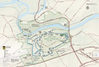
Pennypacker Mills is an American Colonial Revival mansion that is surrounded by 170 acres (0.69 km2) of farmland in Perkiomen Township, near Schwenksville, Pennsylvania. Located on the shore of the Perkiomen Creek, it is situated approximately 35 miles (56 km) northwest of Philadelphia.

References

  1. "ArcGIS REST Services Directory". United States Census Bureau. Retrieved October 16, 2022.
  2. "Census Population API". United States Census Bureau. Retrieved Oct 12, 2022.
  3. 'Catherine Gilbert Murdock - Dairy Queen - Frequently Asked Questions'. Accessed February 11, 2007.
  4. "US Gazetteer files: 2010, 2000, and 1990". United States Census Bureau. 2011-02-12. Retrieved 2011-04-23.
  5. Climate Summary for Schwenksville, Pennsylvania
  6. Washington to Dr. Samuel Kennedy, 26 September 1777 from the National Archives.
  7. "National Register Information System". National Register of Historic Places . National Park Service. July 9, 2010.
  8. "Census of Population and Housing". Census.gov. Retrieved June 4, 2016.
  9. "Montgomery County Election Results". Montgomery County, Pennsylvania. Retrieved January 16, 2017.
  10. "Schwenksville Borough map" (PDF). PennDOT. Retrieved March 10, 2023.
  11. "Elementary school boundary maps. Perkiomen Valley School District. Retrieved on October 9, 2018.
  12. Middle school boundary maps. Perkiomen Valley School District. Retrieved on October 9, 2018.