The first settlement in what is now Brookhaven was known as Setauket. Founded as a group of agricultural hamlets in the mid-17th century, Brookhaven first expanded as a major center of shipbuilding in the 19th century. Its proximity to New York City facilitated the establishment of resort communities, followed by a post-war population boom. In the 2020 census record, Brookhaven contained 485,773 people.[4]
The first known inhabitants were Algonquian-speaking Native Americans, of the Setauket and Unkechaug tribes. The first English settlers arrived around 1640, and in 1655, several purchased Brookhaven's land from its tribal inhabitants. The latter founding year was recognized in 1976, when the Brookhaven Town Bicentennial Commission proposed setting the date on the seal to 1655 in line with this first deed of settlement of the town of Brookhaven at Setauket on April 14, 1655. Considering this founding year of 1655, Brookhaven is the fifth English township on Long Island following Southampton, Southold, Huntington, and East Hampton.
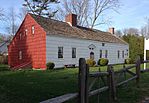
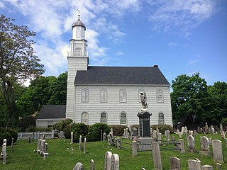
The c. 1665 Brewster House is the oldest extant structure in the town of Brookhaven and is within the town's first settlement, Setauket.The Caroline Church in Setauket, was built in 1729 and is the oldest extant church in Brookhaven
The first English settlement was named "Setauket" after the Native American tribe. The names "Brookhaven" and "Setauket" were initially used interchangeably to describe the village or the town. The verbal division between the smaller hamlet of Setauket and township of Brookhaven was not set until well into the 19th century. A point of confusion is the existence of the hamlet named Brookhaven, which was in fact named for the township in 1879. Other names used in the settlement's first decades were "Ashford", after Ashford, Kent, in England, and "Cromwell Bay", for English Protestant leader Oliver Cromwell.
The original purchase from the native Setalcott tribe that took place in 1655 encompassed the land making up present-day Setauket, Stony Brook, and Port Jefferson. A second purchase was made by Richard Woodhull in 1664 expanded this tract eastward along the North Shore to additionally include all lands from the Old Mans area (Mount Sinai and Miller Place) to Wading River. Richard Woodhull was the direct heir of Eustace de Vesci, a British noble who was a signator of the Magna Charta.[5] Another land purchase in the same year expanded Brookhaven to the South Shore of Long Island.
Brookhaven was integrated into the Province of New York following that colony's establishment in 1664, and in 1666 Governor Richard Nicolls granted a patent for the town which confirmed title to the lands purchased. Governor Thomas Dongan issued a patent in 1686 which granted powers to the town and established a representative form of government.[6] The town seal was authorized at this time. The central element of the town seal, the letter “D”, was designated to the Town of Brookhaven as its official cattle earmark by the Duke's Laws of 1665. Although no records exist dating to the town seal's original design plan, it is generally thought that the seal's olive branch signified peace and the whaling tools signified the most lucrative business in the Town of Brookhaven at the time. The current seal is a redesign, retaining the original elements, but adding the Town of Brookhaven and its 1655 date of settlement.
Colonial era
The Miller Place Academy schoolhouse, c.1834
Early English settlers farmed, fished, and hunted whales. Brookhaven was largely agrarian, with each hamlet being limited to a handful of families yet containing miles of land. This economy was supplemented in coastal sections with fishing. A major commercial center did not exist in Brookhaven until the early 19th century.
Brookhaven was founded primarily by English colonists that partook in the settlement of Southold, and was likewise under the jurisdiction of the theocratic New Haven Colony in the modern state of Connecticut. Brookhaven was transferred to the more secular Hartford-led Connecticut Colony in 1662. Following the English takeover of New Netherland in 1664, the new English colony of New York laid claim to Long Island and brought Brookhaven into its jurisdiction.
American Revolutionary War
During the early stages of the American Revolutionary War, Brookhaven and the rest of Long Island were captured by British forces, and many residents sided with the British as loyalists to the English crown. Nevertheless, Brookhaven had multiple episodes of celebrated American activity during the war. This included the actions of the Culper Spy Ring, a spy network working for George Washington that largely consisted of Brookhaveners working in occupied territory. Another episode was Benjamin Tallmadge's successful raid from across Long Island to the British stronghold at the Manor St. George, wherein his raiding party rowed from Connecticut to Cedar Beach and marched across Long Island, culminating in the Battle of Fort St. George and burning of the defensive structure. A more minor skirmish occurred within the settlement of Setauket, where the British had repurposed the local Protestant church as a fortress. Gunshots were fired and some bullet holes remain within the walls of the adjacent Caroline Church.
Development
Sketch of early PatchogueMather Shipyard in Port Jefferson, 1884
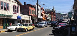
In the mid-19th century, several communities in Brookhaven prospered as shipbuilding ports. The most successful of those were the villages of Port Jefferson and Patchogue, which remain the township's most bustling traditional downtowns. Whaling and cordwood industries also developed in Brookhaven.
Railroads reached Brookhaven in the mid-19th century, beginning in 1843 with trains reaching inland to Ronkonkoma. The earliest equivalent to the North Shore's present-day Port Jefferson Branch began operation in 1873. The Bridgeport & Port Jefferson Ferry has been operating between Port Jefferson and Bridgeport, Connecticut, since 1888 and was partly founded by legendary circus-master P.T. Barnum.
From the end of the late 19th century until the middle of the 20th, many communities along the North Shore and South Shore became successful resort towns. These hosted many urban residents from nearby New York City, including numerous celebrities of the era, during the summer months. Meanwhile, many rural sections across Brookhaven served as campgrounds for youth clubs.
During the Gilded Age, Brookhaven underwent some of the same changes that affected Long Island's Gold Coast. Waterfront areas along the North Shore, including Belle Terre and Old Field, transformed from small fishing communities into fashionable and exclusive enclaves of the moneyed elite.
During the mid-century, a number of major transformations were conducted by philanthropist Ward Melville in the "Three Village" area (The Setaukets, Stony Brook, and Old Field). Melville, an Old Field resident and owner of what later became CVS Corporation, used his fortune to transform Northwestern Brookhaven to his vision of an idealized New England–style region. To this end, he ordered the construction in 1939 of the Stony Brook Village Center, a picturesque commercial center set on village green in Stony Brook, with clapboard buildings designed to look as if they had colonial origins. In 1962, Ward Melville donated 400 acres of land for the relocation of now-named Stony Brook University from Oyster Bay.
Brookhaven is located centrally on the geographic Long Island and extends from the North Shore to the South Shore. According to the United States Census Bureau, the town has a total area of 532.0 square miles (1,378km2), of which 259.6 square miles (672km2) is land and 272.4 square miles (706km2) (51.20%) is water.[7] It is the largest town in New York in terms of total area, excluding water. However, there are four towns in the state with more land area: Arietta in Hamilton County, Long Lake in Hamilton County, Ohio in Herkimer County and Webb in Herkimer County.
A large part of Fire Island (accessible by a bridge at Smith Point) and the Great South Bay are in the town.
Bald Hill, a large hill in the hamlet of Farmingville, marks where the glacier which formed Long Island stopped. At the top of Bald Hill is a Vietnam veterans memorial. Telescope Hill, to the west of Bald Hill Cultural Park, is slightly taller at 334 feet (102m) above sea level and the highest point in the town.
Patchogue was the town seat of Brookhaven until 1986, when it moved to Medford and then its current location near Bald Hill in Farmingville.
Brookhaven is led by a town supervisor and a six-member town council, which are all four-year term elected positions.[10] Council members have been elected by district since a referendum in 2002.[11]
Prior to 2002, the local Republican Party for the Town of Brookhaven nearly controlled the entirety of the town board for several decades, except for a four-year period in the mid-1970s when Democrats held a majority under Supervisor John Randolph.[12]
This one-party domination, and a series of scandals, led to a tarnished reputation of local politics and accorded the nickname "Crookhaven".[13][14]
After the referendum was passed In 2002,[15] Steve Fiore-Rosenfield became the first Democrat to be elected since the 1970s in 2003.[16]
In 2005, Brian X. Foley, a Democratic county legislator, won the town supervisor race.[17] Constance Kepert and Carol Bissonette were also elected to the town board. With the re-election of Fiore-Rosenfield the Democrats gained control of the Brookhaven town board for the first time since the 1970s.[18]
In 2007, councilwoman Carol Bissonette chose not to pursue re-election, but to instead run for the open receiver of taxes seat. Her district, the sixth, was won by Republican Keith Romaine, returning the town to a 4-3 majority on the town board. The new majority opted to elect councilman Tim Mazzei as majority leader.[19]
In 2008, Brian X. Foley was elected to the New York state senate. As per New York state law his seat was declared vacant, a special election was held on March 31, 2009, to replace him. Democrat Mark Lesko.[20] defeated Majority Leader Mazzei to become Supervisor. In August 2012, Lesko chose to step down and join a tech company on Long Island. A special election was held on November 6, 2012, which was won by Republican county legislator Edward P. Romaine, who had previously served as county clerk. With Romaine's victory and the subsequent victories of Daniel Losquadro in 2013 for the special election of highway superintendent, and Independence party member Donna Lent to town clerk, the Republican party and its endorsed allies won all townwide seats for the first time since former supervisor John Jay LaValle.
From Fire Island itself, communities have ferries from Fire Island Pines and Cherry Grove, both of which are popular vacation spots for LGBT tourists as well as the Sailors Haven Visitor's Center,[21] which is located within the Sunken Forest Visitor's Center.[22] All three ferries lead to Sayville in the Town of Islip. Ocean Bay Park is the westernmost community in the Town of Brookhaven, and ferries from there lead to Bay Shore.
Airports
The Town of Brookhaven contains no Commercial Airports. The adjacent Town of Islip contains Long Island MacArthur Airport which serves Brookhaven Residents, three Minor Reliever Airports are within Brookhaven, all of which are in the southern shore communities. The first one is the Brookhaven Calabro Airport in Shirley. East of this is the Spadaro Airport and Lufker Airport both of which are in East Moriches, and both of which share a taxiway. Coram Airport was operational until 1984.[23]
Suffolk County is the easternmost county in the U.S. state of New York. It is bordered to its west by Nassau County, to its east by Gardiners Bay and the Atlantic Ocean, to its north by Long Island Sound, and to its south by Great South Bay. The county is part of the Long Island region of the state, of which it comprises the eastern two-thirds.
Bellport is a village in the Town of Brookhaven in Suffolk County, on the South Shore of Long Island, in New York, United States. The population was 2,084 at the 2010 census.
Setauket is a hamlet and census-designated place (CDP) in the Town of Brookhaven, Suffolk County, New York, United States, on the North Shore of Long Island. As of the 2010 United States census, the CDP population, which at the time included East Setauket as well, was 15,477.
Montauk Highway is an east–west road extending for 95 miles (153 km) across the southern shore of Long Island in Suffolk County, New York, in the United States. It extends from the Nassau County line in Amityville, where it connects to Merrick Road, to Montauk Point State Park at the very eastern end of Long Island in Montauk. The highway is known by several designations along its routing, primarily New York State Route 27A (NY 27A) from the county line to Oakdale and NY 27 east of Southampton. The portion of Montauk Highway between Oakdale and Southampton is mostly county-maintained as County Route 80 and County Route 85.
The South Shore of Long Island, in the U.S. state of New York, is the area along Long Island's Atlantic Ocean shoreline.
New York's 1st congressional district is a congressional district for the United States House of Representatives in eastern Long Island. It includes the eastern two-thirds of Suffolk County, including the northern portion of Brookhaven, as well as the entirety of the towns of Huntington, Smithtown, Riverhead, Southold, Southampton, East Hampton, and Shelter Island. The district encompasses extremely wealthy enclaves such as the Hamptons, middle class suburban towns such as Selden, Centereach, and Lake Grove, working-class towns such as Riverhead and rural farming communities such as Mattituck and Jamesport on the North Fork. The district currently is represented by Republican Nick LaLota who lives in Amityville, outside of the district.
New York's 2nd congressional district is a congressional district for the United States House of Representatives along the South Shore of Long Island, New York. It includes southwestern Suffolk County and a small portion of southeastern Nassau County. The district is currently represented by Republican Andrew Garbarino.
The Outer Barrier, also known as the Long Island and New York City barrier islands, refers to the string of barrier islands that divide the lagoons south of Long Island, New York from the Atlantic Ocean. These islands include Long Beach Barrier Island, Barnum Island, Jones Beach Island, Fire Island and Westhampton Island. The outer barrier extends 75 miles (121 km) along the South Shore of Long Island, from the Rockaway Peninsula in New York City to the east end of Shinnecock Bay in Suffolk County.
Suffolk County Transit is the provider of bus services in Suffolk County, New York, on Long Island and is an agency of the Suffolk County government. It was founded in 1980 as a county-run oversight and funding agency for a group of private contract operators which had previously provided such services on their own. While the physical maintenance and operation of the buses continue to be provided by these providers, other matters ranging from bus purchases to route and schedule planning to fare rules are set by Suffolk Transit itself.
County Route 16 (CR 16) is a main thoroughfare through central Suffolk County, New York, in the United States. Its western terminus is at Middle Country Road in Village of the Branch, and its eastern terminus is at Montauk Highway (CR 80) in Brookhaven. The route carries five different names along its length: Terry Road, Smithtown Boulevard, Lake Shore Road, Portion Road, and Horseblock Road.
Patchogue Bay is a lagoon on the south-central shores of Long Island in the U.S. state of New York.
Moriches Bay is a lagoon system on the south shore of Long Island, New York. The name Moriches comes from Meritces, a Native American who owned land on Moriches Neck.
This page is based on this Wikipedia article Text is available under the CC BY-SA 4.0 license; additional terms may apply. Images, videos and audio are available under their respective licenses.