Jamesport, New York

Last updated

Jamesport, New York
Jamesport, New York.jpg
Jamesport, New York
Jamesport-ny-map.gif
Location map Long Island.png
Red pog.svg
Jamesport
USA New York location map.svg
Red pog.svg
Jamesport
Usa edcp location map.svg
Red pog.svg
Jamesport
Coordinates: 40°56′40″N72°34′38″W / 40.94444°N 72.57722°W / 40.94444; -72.57722
Country United States
State New York
County Suffolk
Town Riverhead
Area
[1]
  Total4.52 sq mi (11.72 km2)
  Land4.50 sq mi (11.65 km2)
  Water0.03 sq mi (0.07 km2)
Elevation
16 ft (5 m)
Population
 (2020)
  Total1,609
  Density6,352/sq mi (2,449/km2)
Time zone UTC-5 (Eastern (EST))
  Summer (DST) UTC-4 (EDT)
ZIP code
11947
Area code 631
FIPS code 36-38253
GNIS feature ID0953924

Jamesport is a village in Riverhead, Suffolk County, New York. At the 2020 U.S. Census the population was 1,609. [2]

Contents

Bay Breeze Inn in South Jamesport. Inn Exterior Dusk DSC 2245 160 REV 3000pix.jpg
Bay Breeze Inn in South Jamesport.

Jamesport consists of a downtown area and surrounding farms.

Hallock State Park Preserve (previously Jamesport State Park ) is located north of Jamesport in the adjacent village of Northville.

Geography

The United States Census Bureau estimated that Jamesport had a total area of 4.5 square miles (11.7 km2), of which 4.5 square miles (11.6 km2) was made out of land and 0.039 square miles (0.1 km2), or 0.60%, was made out of water. [3]

History

Jamesport was first settled in the 1690s and was originally called "Aquebogue." It became "Lower Aquebogue" when another hamlet called "Upper Aquebogue" was established to the west. The Jamesport Meeting House, built in 1731, is the oldest operating church building in Suffolk County [4]

The name "Jamesport" refers to James Tuthill, a man who settled in the area south of Lower Aquebogue on the Peconic Bay with his family in 1833. [5] Over time, Lower Aquebogue came to be called Jamesport, while the community 1 mile (2 km) to the south, previously called Jamesport, came to be called South Jamesport (and is included in the present-day Jamesport CDP). Upper Aquebogue became Aquebogue.

James Tuthill's attempt to establish a commercial whaling and shipping wharf on the Peconic Bay in what is now South Jamesport was a failure. The depth of water at low tide was too shallow to accommodate ships. However, the Long Island Rail Road established service to Jamesport from New York City, and Jamesport became a popular resort and fishing community with several large bayfront hotels. These included the Miamogue Hotel and the Great Peconic Bay House, [6] which operated until 1952. Jamesport was a center for the scallop and bunker (menhaden) fisheries.

From the 1830s to about 1950, Jamesport was the site of a camp meeting grove operated by the Methodist Episcopal Church and, after 1904, an Epworth League Fresh Air Camp.

During the 1960s, the Long Island Lighting Company (LILCO) designated land on the North Shore of Long Island for use as a possible second nuclear power station, in addition to its Shoreham plant already under construction. However, the Jamesport plan was scrapped when LILCO ran into opposition to Shoreham in the 1970s and 1980s.

Demographics

Historical population
CensusPop.Note
2010 31,146
2020 28,712−7.8%
U.S. Decennial Census [7]

As of the census of 2020, there are 1,609 people, 469 households, and 1,126 housing units in Jamesport. The population density is 216.0 per square mile. The ethnic makeup of the CDP is 88.6% White, 1.5% African American, 0.4% Asian, 0.06% Pacific Islander, 0.43% from other ethnicities, and 0.48% from two or more ethnicities. Hispanic or Latino of any ethnicity are 11% of the population. [8]

There are 469 households, out of which 56.7% are married couples living together, 29.4% have a female householder with no spouse present, and 3.2% have a male householder with no spouse present.

10.2% of the population are minors. 9.9% of the population is classified as living below the poverty line.

Schools

Related Research Articles

<span class="mw-page-title-main">Suffolk County, New York</span> County in New York, United States

Suffolk County is the easternmost county in the U.S. state of New York. It comprises the eastern two-thirds of Long Island, bordered to its west by Nassau County, to its east by Gardiners Bay and the Atlantic Ocean, to its north by Long Island Sound, and to its south by Great South Bay.

<span class="mw-page-title-main">Aquebogue, New York</span> Hamlet and census-designated place in New York, United States

Aquebogue is a census-designated place (CDP) roughly corresponding to the hamlet by the same name in the Town of Riverhead in Suffolk County, on Long Island, in New York, United States. The CDP's population was 2,438 at the 2010 census.

<span class="mw-page-title-main">Calverton, New York</span> Hamlet and census-designated place in New York, United States

Calverton is a hamlet and census-designated place (CDP) on eastern Long Island in Suffolk County, New York, United States. The population was 6,510 at the 2010 census.

<span class="mw-page-title-main">East Shoreham, New York</span> Hamlet and census-designated place in New York, United States

East Shoreham is a hamlet and census-designated place (CDP) in the Suffolk County town of Brookhaven, New York, United States. The population was 6,841 at the 2020 census.

<span class="mw-page-title-main">Flanders, New York</span> Hamlet and census-designated place in New York, United States

Flanders is a hamlet and a census-designated place (CDP) in Suffolk County, New York, United States. The population was 4,472 at the 2010 census. It is the location of the Big Duck.

<span class="mw-page-title-main">Hampton Bays, New York</span> Hamlet and census-designated place in New York, United States

Hampton Bays is a hamlet and census-designated place (CDP) in the Town of Southampton in Suffolk County, on Long Island, in New York. It is considered as part of the region of Long Island known as The Hamptons. The population was 13,603 at the 2010 census.

<span class="mw-page-title-main">Laurel, New York</span> Hamlet and census-designated place in New York, United States

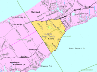
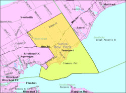
Laurel is a census-designated place (CDP) roughly corresponding to the hamlet of Laurel in Suffolk County, New York, United States. It is located mostly within the Town of Southold, with a small portion in the Town of Riverhead. The population was 1,394 at the 2010 census.

<span class="mw-page-title-main">Manorville, New York</span> Hamlet and census-designated place in New York, United States

Manorville is a hamlet and census-designated place (CDP) in Suffolk County, New York, United States. The population was 14,314 at the 2010 census.

<span class="mw-page-title-main">Medford, New York</span> Hamlet & census-designated place in New York, United States

Medford is a hamlet and census-designated place (CDP) in the Town of Brookhaven in Suffolk County, on Long Island, in New York, United States. The population was 24,247 at the 2020 census.

<span class="mw-page-title-main">Peconic, New York</span> Hamlet and census-designated place in New York, United States

Peconic is a census-designated place (CDP) that roughly corresponds to the hamlet by the same name in the Town of Southold in Suffolk County, New York, United States. The CDP population was 683 at the 2010 census.

<span class="mw-page-title-main">Shoreham, New York</span> Village in New York, United States

Shoreham is an incorporated village in the Town of Brookhaven, Suffolk County, New York, United States. The population was 531 at the 2010 census. It is officially known as the Incorporated Village of Shoreham.

<span class="mw-page-title-main">Wading River, New York</span> Hamlet and census-designated place in New York, United States

Wading River is a hamlet and census-designated place (CDP) in Suffolk County, New York, United States, on the North Shore of Long Island. As of the 2010 census, the CDP population was 7,719. It is adjacent to Shoreham and shares a school district.

<span class="mw-page-title-main">Riverhead (CDP), New York</span> Hamlet and census-designated place in New York, United States

Riverhead is a census-designated place (CDP) roughly corresponding to the hamlet by the same name located in the Town of Riverhead in Suffolk County, on Long Island, in New York, United States. The CDP's population was 13,299 at the 2010 census.

<span class="mw-page-title-main">Riverhead, New York</span> Town in New York, United States

Riverhead is a town in Suffolk County, New York, United States, on the north shore of Long Island. Since 1727, Riverhead has been the county seat of Suffolk County, though most county offices are in Hauppauge. As of the 2020 census, the population was 35,902. The town rests on the mouth of the Peconic River, from which it derives its name. The smaller hamlet of Riverhead lies within it, and is the town's principal economic center. The town is 166 miles (267 km) southwest of Boston via the Orient Point-New London Ferry, and is 76 miles (123 km) northeast of New York City.

<span class="mw-page-title-main">Southold, New York</span> Town in New York, United States

The Town of Southold is one of ten towns in Suffolk County, New York, United States. It is located in the northeastern tip of the county, on the North Fork of Long Island. The population was 23,732 at the 2020 census. The town also contains a hamlet named Southold, which was settled in 1640.

<span class="mw-page-title-main">Peconic County, New York</span> Hypothetical new county on Long Island, New York

Peconic County is a proposed new county on Long Island in the U.S. state of New York that would secede the five easternmost towns of Suffolk County: East Hampton, Riverhead, Shelter Island, Southampton and Southold, plus the Shinnecock Indian Reservation.

<span class="mw-page-title-main">North Fork (Long Island)</span> Peninsula on Long Island, New York, United States

The North Fork is a 30-mile- (48 km) long peninsula in the northeast part of Suffolk County, New York, U.S., roughly parallel with a longer peninsula known as the South Fork, both on the East End of Long Island. Although the peninsula begins east of Riverhead hamlet, the term North Fork can also refer collectively to the towns of Riverhead and Southold in their entirety.

<span class="mw-page-title-main">Shoreham Nuclear Power Plant</span> Decommissioned nuclear power plant in New York

The Shoreham Nuclear Power Plant was a completed General Electric nuclear boiling water reactor located adjacent to Long Island Sound in East Shoreham, New York.

<span class="mw-page-title-main">New York's 1st congressional district</span> U.S. House district for New York

New York's 1st congressional district is a congressional district for the United States House of Representatives in eastern Long Island. It includes the eastern two-thirds of Suffolk County, including the northern portion of Brookhaven, as well as the entirety of the towns of Huntington, Smithtown, Riverhead, Southold, Southampton, East Hampton, and Shelter Island. The district encompasses extremely wealthy enclaves such as the Hamptons, middle class suburban towns such as Selden, Centereach and Lake Grove, working-class towns such as Riverhead and rural farming communities such as Mattituck and Jamesport on the North Fork. The district currently is represented by Republican Nick LaLota who lives in Amityville, outside of the district.

Riverhead Central School District is a public school district located in the eastern part of Suffolk County, New York, United States. It primarily serves the Town of Riverhead, as well as 10 square miles (26 km2) in the Town of Southampton and 3 square miles (8 km2) in the Town of Brookhaven, and includes the census-designated places(CDPs) of Aquebogue, Baiting Hollow, Northville, Riverhead, and Riverside, and portions of Calverton, Flanders, Hampton Bays, Jamesport, Northampton, and Wading River. The total district size is 81 square miles (210 km2).

References

  1. "ArcGIS REST Services Directory". United States Census Bureau. Retrieved September 20, 2022.
  2. "Explore Census Data". data.census.gov. Retrieved February 1, 2024.
  3. "Geographic Identifiers: 2010 Demographic Profile Data (G001): Jamesport CDP, New York". U.S. Census Bureau, American Factfinder. Archived from the original on February 12, 2020. Retrieved January 2, 2013.
  4. "Who We Are". Jamesport Meeting House. Retrieved December 11, 2022.
  5. "History". East Long Island. Retrieved October 25, 2021.
  6. "The News Review Online - The Hometown Newspaper of Riverhead Town, Long Island New York". www.timesreview.com. Archived from the original on December 19, 2009.
  7. "Census of Population and Housing". Census.gov. Retrieved June 4, 2016.
  8. "U.S. Census website". United States Census Bureau . Retrieved January 31, 2008.