Baiting Hollow, New York

Last updated

Baiting Hollow, New York
Beach at Baiting Hollow Scout Camp.jpg
A beach in Baiting Hollow.
Baiting-hollow-map.png
U.S. Census map of Baiting Hollow.
USA New York location map.svg
Red pog.svg
Baiting Hollow
Location within the state of New York.
Coordinates: 40°58′3″N72°44′26″W / 40.96750°N 72.74056°W / 40.96750; -72.74056
Country Flag of the United States.svg  United States
State Flag of New York.svg  New York
County Suffolk
Town Riverhead
Area
[1]
  Total7.42 sq mi (19.23 km2)
  Land5.21 sq mi (13.49 km2)
  Water2.21 sq mi (5.74 km2)
Elevation
105 ft (32 m)
Population
 (2020)
  Total2,763
  Density530.33/sq mi (204.76/km2)
Time zone UTC-5 (Eastern (EST))
  Summer (DST) UTC-4 (EDT)
ZIP code
11933
Area codes 631, 934
FIPS code 36-04055
GNIS feature ID0942815
Baiting Hollow in 1931 New York - Amagansett through Blue Point - NARA - 68145397 (cropped).jpg
Baiting Hollow in 1931

Baiting Hollow is a census-designated place (CDP) roughly corresponding to the hamlet by the same name in the Town of Riverhead in Suffolk County, on Long Island, in New York, United States. The CDP's population was 1,642 at the 2010 census. [2]

Contents

Geography

According to the United States Census Bureau, the CDP has a total area of 3.2 square miles (8.3 km2), all of it land. [2]

Climate

Climate data for Baiting Hollow, New York, 1991–2020 normals, extremes 2007present
MonthJanFebMarAprMayJunJulAugSepOctNovDecYear
Record high °F (°C)68
(20)
71
(22)
77
(25)
87
(31)
92
(33)
94
(34)
98
(37)
95
(35)
93
(34)
90
(32)
78
(26)
64
(18)
98
(37)
Mean daily maximum °F (°C)38.4
(3.6)
39.5
(4.2)
46.8
(8.2)
57.0
(13.9)
68.0
(20.0)
76.8
(24.9)
82.6
(28.1)
81.3
(27.4)
74.7
(23.7)
63.5
(17.5)
52.8
(11.6)
43.4
(6.3)
60.4
(15.8)
Daily mean °F (°C)30.3
(−0.9)
31.4
(−0.3)
37.8
(3.2)
47.4
(8.6)
57.3
(14.1)
66.5
(19.2)
72.6
(22.6)
71.5
(21.9)
65.0
(18.3)
53.7
(12.1)
44.1
(6.7)
35.1
(1.7)
51.1
(10.6)
Mean daily minimum °F (°C)22.2
(−5.4)
23.2
(−4.9)
28.7
(−1.8)
37.8
(3.2)
46.7
(8.2)
56.3
(13.5)
62.6
(17.0)
61.7
(16.5)
55.2
(12.9)
43.9
(6.6)
35.4
(1.9)
26.9
(−2.8)
41.7
(5.4)
Record low °F (°C)−4
(−20)
−5
(−21)
4
(−16)
20
(−7)
26
(−3)
40
(4)
46
(8)
46
(8)
36
(2)
25
(−4)
15
(−9)
8
(−13)
−5
(−21)
Average precipitation inches (mm)3.82
(97)
2.72
(69)
4.99
(127)
4.25
(108)
3.70
(94)
3.95
(100)
3.32
(84)
3.84
(98)
4.26
(108)
4.74
(120)
3.92
(100)
5.10
(130)
48.61
(1,235)
Average precipitation days (≥ 0.01 in)11.011.111.112.713.010.610.111.010.914.110.412.8138.8
Source 1: NOAA [3]
Source 2: National Weather Service [4]

Demographics

Historical population
CensusPop.Note
2020 2,763
U.S. Decennial Census [5]

As of the census of 2000, there were 1,449 people, 600 households, and 429 families residing in the CDP. The population density was 448.7 inhabitants per square mile (173.2/km2). There were 962 housing units at an average density of 297.9 per square mile (115.0/km2). The racial makeup of the CDP was 96.27% White, 1.38% African American, 0.55% Asian, 0.97% from other races, and 0.83% from two or more races. Hispanic or Latino of any race were 4.00% of the population. [6]

There were 600 households, out of which 24.2% had children under the age of 18 living with them, 63.0% were married couples living together, 5.3% had a female householder with no husband present, and 28.5% were non-families. 24.3% of all households were made up of individuals, and 8.2% had someone living alone who was 65 years of age or older. The average household size was 2.39 and the average family size was 2.84. [6]

In the CDP, the population was spread out, with 18.9% under the age of 18, 4.8% from 18 to 24, 29.3% from 25 to 44, 33.7% from 45 to 64, and 13.3% who were 65 years of age or older. The median age was 44 years. For every 100 females, there were 108.2 males. For every 100 females age 18 and over, there were 101.2 males. [6]

The median income for a household in the CDP was $128,622, and the median income for a family was $126,455. Males had a median income of $128,036 versus $121,685 for females. The per capita income for the CDP was $96,375. About 1.8% of families and 4.4% of the population were below the poverty line, including none of those under age 18 and 13.8% of those age 65 or over. [6]

Economy

Education

School district

Baiting Hollow is located entirely within the boundaries of the Riverhead Central School District. [7] [8] As such, all children who reside within Baiting Hollow and attend public schools go to Riverhead's schools. [7] [8]

Library district

Baiting Hollow is located within the boundaries of the Baiting Hollow Free Library. [7] The boundaries of this library district correspond with those of the hamlet. [7]

Notable people

Related Research Articles

<span class="mw-page-title-main">Baldwin Harbor, New York</span> Hamlet and former census-designated place in New York, United States

Baldwin Harbor is a hamlet and former census-designated place (CDP) in the Town of Hempstead, in Nassau County, on Long Island, in New York, United States. It was created concomitant with the 1990 United States Census from the southernmost portions of the neighboring hamlet of Baldwin. As of the 2010 census, it had a population of 8,102.

<span class="mw-page-title-main">Bay Park, New York</span> Hamlet and census-designated place in New York, United States

Bay Park is a hamlet and census-designated place (CDP) in the Town of Hempstead in Nassau County, on the South Shore of Long Island, in New York, United States. The population was 2,212 at the 2010 census.

<span class="mw-page-title-main">Garden City Park, New York</span> Hamlet and census-designated place in New York, United States

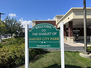
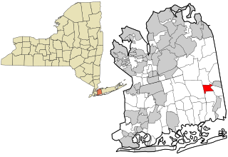
Garden City Park is a hamlet and census-designated place (CDP) located in the Town of North Hempstead in Nassau County, on Long Island, in New York, United States. The population was 7,806 at the 2010 census.

<span class="mw-page-title-main">North Massapequa, New York</span> Hamlet and census-designated place in New York, United States

North Massapequa is a hamlet and census-designated place (CDP) located on Long Island within the Town of Oyster Bay in Nassau County, on Long Island, in New York, United States. It is considered part of the Greater Massapequa area, which is anchored by Massapequa. The population was 17,886 at the 2010 census.

<span class="mw-page-title-main">North Wantagh, New York</span> Hamlet and Census-designated place in New York, United States

North Wantagh is a hamlet and census-designated place in the Town of Hempstead in Nassau County, on the South Shore of Long Island, in New York, United States. The population was 11,960 at the 2010 census.

<span class="mw-page-title-main">Plainedge, New York</span> Hamlet and census-designated place in New York, United States

Plainedge is a hamlet and census-designated place (CDP) in the Town of Oyster Bay in Nassau County, on Long Island, in New York, United States. The population was 8,817 at the 2010 census.

<span class="mw-page-title-main">Woodbury, Nassau County, New York</span> Hamlet and census-designated place in New York, United States

Woodbury is a hamlet and census-designated place (CDP) located within the Town of Oyster Bay in Nassau County, on Long Island, in New York, United States. The population was 9,335 at the 2020 census.

<span class="mw-page-title-main">Aquebogue, New York</span> Hamlet and census-designated place in New York, United States

Aquebogue is a census-designated place (CDP) roughly corresponding to the hamlet by the same name in the Town of Riverhead in Suffolk County, on Long Island, in New York, United States. The CDP's population was 2,438 at the 2010 census.

<span class="mw-page-title-main">Baywood, New York</span> Hamlet and census-designated place in New York, United States

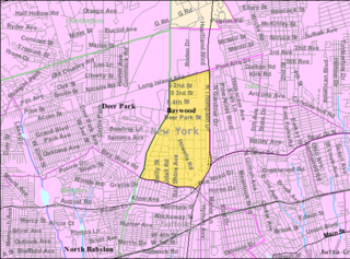
Baywood is a hamlet and census-designated place (CDP) in the Town of Islip in Suffolk County, on Long Island, in New York, United States. The population was 7,350 at the 2010 census.

<span class="mw-page-title-main">Calverton, New York</span> Hamlet and census-designated place in New York, United States

Calverton is a hamlet and census-designated place (CDP) on eastern Long Island in Suffolk County, New York, United States. The population was 6,510 at the 2010 census.

<span class="mw-page-title-main">East Shoreham, New York</span> Hamlet and census-designated place in New York, United States

East Shoreham is a hamlet and census-designated place (CDP) in the Suffolk County town of Brookhaven, New York, United States. The population was 6,841 at the 2020 census.

<span class="mw-page-title-main">Eatons Neck, New York</span> Hamlet and census-designated place in New York, United States

Eatons Neck is a hamlet and census-designated place (CDP) in the Town of Huntington in Suffolk County, on the North Shore of Long Island, in New York, United States. The population was 1,406 at the 2010 census.

<span class="mw-page-title-main">Fort Salonga, New York</span> Hamlet and census-designated place in New York, United States

Fort Salonga is a hamlet and census-designated place (CDP) in the Towns of Huntington and Smithtown in Suffolk County, on the North Shore of Long Island, in New York, United States. The population was 10,008 at the 2010 census.

<span class="mw-page-title-main">Gordon Heights, New York</span> Hamlet and census-designated place in New York, United States

Gordon Heights is a hamlet and census-designated place (CDP) in the Town of Brookhaven, Suffolk County, Long Island, New York, United States. The population was 3,981 at the 2020 census.

<span class="mw-page-title-main">Laurel, New York</span> Hamlet and census-designated place in New York, United States

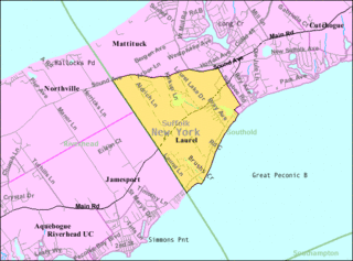
Laurel is a census-designated place (CDP) roughly corresponding to the hamlet of Laurel in Suffolk County, New York, United States. It is located mostly within the Town of Southold, with a small portion in the Town of Riverhead. The population was 1,394 at the 2010 census.

<span class="mw-page-title-main">North Bellport, New York</span> Hamlet and census-designated place in New York, United States

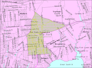
North Bellport is a hamlet and census-designated place (CDP) located within the Town of Brookhaven, New York, United States. The population was 11,545 at the 2010 census.

<span class="mw-page-title-main">Northville, Suffolk County, New York</span> Place in New York, United States

Northville is a hamlet and census-designated place (CDP) in the Town of Riverhead in Suffolk County, on Long Island, in New York, United States. The CDP population was 1,340 at the 2010 census. Between 1921 and 1930, it was an incorporated village known originally as the Incorporated Village of Sound Avenue, and from 1927 to 1930 as the Incorporated Village of Northville.

<span class="mw-page-title-main">Port Jefferson Station, New York</span> Hamlet & census-designated place in New York, United States

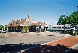
Port Jefferson Station is a hamlet and census-designated place (CDP) in the Town of Brookhaven, in Suffolk County, in New York, United States. The population was 7,838 as of the 2010 census.

<span class="mw-page-title-main">Wading River, New York</span> Hamlet and census-designated place in New York, United States

Wading River is a hamlet and census-designated place (CDP) in Suffolk County, New York, United States, on the North Shore of Long Island. As of the 2010 census, the CDP population was 7,719. It is adjacent to Shoreham and shares a school district.

<span class="mw-page-title-main">Riverhead (CDP), New York</span> Hamlet and census-designated place in New York, United States

Riverhead is a census-designated place (CDP) roughly corresponding to the hamlet by the same name located in the Town of Riverhead in Suffolk County, on Long Island, in New York, United States. The CDP's population was 13,299 at the 2010 census.

References

  1. "ArcGIS REST Services Directory". United States Census Bureau. Retrieved September 20, 2022.
  2. 1 2 "Geographic Identifiers: 2010 Demographic Profile Data (G001): Baiting Hollow CDP, New York". U.S. Census Bureau, American Factfinder. Archived from the original on February 12, 2020. Retrieved December 24, 2012.
  3. "U.S. Climate Normals Quick Access – Station: Baiting Hollow, NY". National Oceanic and Atmospheric Administration. Retrieved February 25, 2023.
  4. "NOAA Online Weather Data – NWS New York". National Weather Service. Retrieved February 25, 2023.
  5. "Census of Population and Housing". Census.gov. Retrieved June 4, 2016.
  6. 1 2 3 4 "U.S. Census website". United States Census Bureau . Retrieved January 31, 2008.
  7. 1 2 3 4 "Long Island Index: Interactive Map". Long Island Index Maps. Long Island Index.
  8. 1 2 "Composite School District Boundaries Shapefiles". NCES. Retrieved October 23, 2020.
  9. Biography Archived 2007-10-09 at the Wayback Machine at the New England Auto Racers Hall of Fame, Retrieved October 2, 2007