Southaven County Park

Last updated
The entrance to Southaven County Park on Victory Avenue. Taken in November 2013. Southaven County Park Entrance-3.JPG
The entrance to Southaven County Park on Victory Avenue. Taken in November 2013.

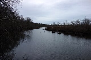
Southaven County Park is located in Brookhaven and South Haven, New York in central Long Island. It is located between Sunrise Highway (Route 27) just west of William Floyd Parkway, off of Victory Avenue (Suffolk CR 56/North Sunrise Service Road), and crossed by the Carmans River.

Brookhaven (CDP), New York Hamlet and census-designated place in New York, United States

Brookhaven is a hamlet and census-designated place in Suffolk County, New York, United States. The population was 3,451 at the 2010 census.

South Haven, New York Hamlet in New York, United States

South Haven is a hamlet in Suffolk County, New York, on the South Shore of Long Island.

Long Island island in New York, United States of America

Long Island is a densely populated island off the East Coast of the United States, beginning at New York Harbor approximately 0.35 miles (0.56 km) from Manhattan Island and extending eastward into the Atlantic Ocean. The island comprises four counties in the U.S. state of New York. Kings and Queens Counties and Nassau County share the western third of the island, while Suffolk County occupies the eastern two-thirds. More than half of New York City's residents now live on Long Island, in Brooklyn and Queens. However, many people in the New York metropolitan area colloquially use the term Long Island to refer exclusively to Nassau and Suffolk Counties, which are mainly suburban in character, conversely employing the term the City to mean Manhattan alone.

In the 1960s, it became one of Suffolk County’s first parks opened to the public. The territory of the parkland reaches as far north as East Main Street and Yaphank Avenue in Yaphank, which contains the historic Homan-Gerard House and Mills as well as the Mary Louise Booth Girlhood Home. Segments of the Long Island Expressway and the Main Line of the Long Island Rail Road runs through the park, [1] though it is accessible from neither the LIE nor the railroad. The park has become famous for being the crash site of an alleged UFO in 1992.

Suffolk County, New York county in New York

Suffolk County is a predominantly suburban county on Long Island and the easternmost county in the U.S. state of New York. As of the 2010 census, the county's population was 1,493,350, estimated to have decreased slightly to 1,492,953 in 2017, making it the fourth-most populous county in New York. Its county seat is Riverhead, though most county offices are in Hauppauge. The county was named after the county of Suffolk in England, from where its earliest European settlers came.

Homan-Gerard House and Mills

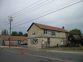
Homan-Gerard House and Mills is a historic home and mill complex located at Yaphank in Suffolk County, New York. It is composed of a large Federal-style residence, four contributing related support buildings, and six contributing related archaeological sites. The house is a ​2 12-story frame residence with a three-bay facade, gambrel roof, center chimney, and kitchen wing. Also on the property are three small sheds and a large 2-story, late-19th-century barn. Archaeological remains include that of the J. P. Mills Store and Homan-Gerard saw mill and grist mill.

Mary Louise Booth American editor, translator and writer

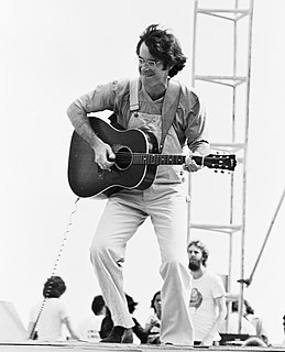
Mary Louise Booth was an American editor, translator and writer. She was the first editor-in-chief of Harper's Bazaar.

Related Research Articles

Bellport, New York Village in New York, United States

Bellport is a village in Suffolk County, New York, United States. The population was 2,084 at the 2010 census. The village is named after the Bell family, early settlers of the area. The public education system in Bellport makes up the South Country Central School District consisting of six schools, three elementary schools, Frank P. Long Intermediate School, Bellport Middle School and Bellport High School. Bellport is in the town of Brookhaven and is on the South Shore of Long Island. The village is officially known as the Incorporated Village of Bellport.

Medford, New York Hamlet and census-designated place in New York, United States

Medford is a hamlet and census-designated place (CDP) in Suffolk County, New York, United States. The population was 24,142 at the 2010 census.

Southold, New York Town in New York, United States

The Town of Southold is one of ten towns in Suffolk County, New York, United States. It is located in the northeastern tip of the county, on the North Fork of Long Island. The population was 21,968 at the 2010 census. The town also contains a hamlet named Southold, which was settled in 1640.

Brookhaven, New York Town in New York, United States

The Town of Brookhaven is the most populous of the ten towns of Suffolk County, New York, United States. Part of the New York metropolitan area, it is located approximately 50 miles from Manhattan. It is the only town in the county that stretches from the North Shore to the South Shore of Long Island. It is the largest of New York State's 932 towns, and the second most populous, exceeded only by the Town of Hempstead.

New York State Route 27 highway in New York

New York State Route 27 (NY 27) is a 120.58-mile (194.05 km) long state highway that runs east-west from Interstate 278 (I-278) in the New York City borough of Brooklyn to Montauk Point State Park on Long Island, New York. Its two most prominent components are Sunrise Highway and Montauk Highway, the latter of which includes the Montauk Point State Parkway. NY 27 acts as the primary east–west highway on southern Long Island east of the interchange with the Heckscher State Parkway in Islip Terrace. The entire route in Suffolk, Nassau, and Queens counties was designated by the New York State Senate as the POW/MIA Memorial Highway. The highway gives access to every town on the South Shore. NY 27 has service roads that parallel the highway continuously from North Lindenhurst to Patchogue, and intermittently to the east into Southampton. They are officially designated, but not signed, as New York State Route 906C and New York State Route 906D.

County Route 16 (Suffolk County, New York)

County Route 16 (CR 16) is a main thoroughfare through central Suffolk County, New York, in the United States. Its western terminus is at Middle Country Road in Smithtown, on the eastern border of the Village of the Branch, and its eastern terminus is at Montauk Highway (CR 80) in Brookhaven near Southhaven. The route carries five different names along its length.

County Route 46 (Suffolk County, New York)

County Route 46 (CR 46) is a major county road in eastern Suffolk County, New York, in the United States. It runs south-to-north from CR 75 in Smith Point County Park to New York State Route 25A (NY 25A) near the border of Shoreham and Wading River. The road is known as the William Floyd Parkway along its entire length, and is named after William Floyd, a Long Island native and a signer of the United States Declaration of Independence. Despite its "parkway" designation within the State of New York, the road is open to commercial vehicles.

The South Country Central School District is a district of approximately 16 square miles (41 km2) located in southern Brookhaven Town, Suffolk County, New York, United States. It is composed of the Village of Bellport, the Hamlets of Brookhaven, North Bellport, and East Patchogue, and parts of Yaphank, and Medford.

Patchogue station

Patchogue is a station of the Montauk Branch of the Long Island Rail Road in the village of Patchogue, New York. It is on Division Street between West Avenue and South Ocean Avenue. This train station is located in the Patchogue-Medford Union Free School District.

Ronkonkoma station

Ronkonkoma is a major railroad station and transportation hub along the Main Line of the Long Island Rail Road in Ronkonkoma, New York. The station is the eastern terminus of the Ronkonkoma Branch and the western terminus of the Greenport Branch.

Yaphank station

Yaphank is a station in the hamlet of Yaphank, New York on the Main Line of the Long Island Rail Road. It is located on Park Street near Suffolk County Road 21. It is also accessible from streets in and around Suffolk County. The distance between Yaphank and the next station, Riverhead, is the longest distance between stations in the LIRR at 14.7 miles (23.7 km). Government Buildings on the north side of the tracks at the bottom of the Yaphank Avenue overpass.

Carmans River river in the United States of America

The Carmans River is a 10-mile (16 km) long river in Town of Brookhaven in Suffolk County on Long Island.

Railroad Museum of Long Island

The Railroad Museum of Long Island is a railway museum based on the North Fork, of Long Island, New York, in the United States. It has two locations, a main location in Riverhead, and a satellite location in Greenport, west of the North Ferry to Shelter Island. Both facilities contain active model railroad displays and gift shops.

Suffolk Meadows

Suffolk Meadows was a quarter horse racing facility on Long Island that operated during 1977 and 1986. The racetrack was situated on a 65-acre (0.26 km2) parcel located in Yaphank northwest of the William Floyd Parkway interchange on the Long Island Expressway.

References


Coordinates: 40°49′09″N72°53′54″W / 40.81917°N 72.89833°W / 40.81917; -72.89833

Geographic coordinate system Coordinate system

A geographic coordinate system is a coordinate system that enables every location on Earth to be specified by a set of numbers, letters or symbols. The coordinates are often chosen such that one of the numbers represents a vertical position and two or three of the numbers represent a horizontal position; alternatively, a geographic position may be expressed in a combined three-dimensional Cartesian vector. A common choice of coordinates is latitude, longitude and elevation. To specify a location on a plane requires a map projection.