Village of the Branch, New York

Last updated

Village of the Branch, New York
Incorporated Village of the Branch
Village of the Branch Village Hall, Village of the Branch, NY April 14, 2024 B.jpg
The Branch Village Hall in 2024.
Nickname(s): 
Branch Village; The Branch; Branch
Village-branch-map.gif
Location map Long Island.png
Red pog.svg
Village of the Branch
Location on Long Island
USA New York location map.svg
Red pog.svg
Village of the Branch
Location within the state of New York
Coordinates: 40°51′15″N73°11′0″W / 40.85417°N 73.18333°W / 40.85417; -73.18333
Country Flag of the United States.svg  United States
State Flag of New York.svg  New York
County Suffolk
Town Smithtown
Incorporated 1927
Government
[1]
   Mayor Mark Delaney
Area
[2]
  Total0.98 sq mi (2.54 km2)
  Land0.95 sq mi (2.46 km2)
  Water0.03 sq mi (0.08 km2)
Elevation
62 ft (19 m)
Population
 (2020)
  Total1,735
  Density1,826.32/sq mi (705.13/km2)
Time zone UTC-5 (Eastern (EST))
  Summer (DST) UTC-4 (EDT)
Area codes 631, 934
FIPS code 36-77519
GNIS feature ID0973410
Website www.villageofthebranch.net

Village of the Branch (also known as Branch Village, The Branch, or simply Branch) is a village in the Town of Smithtown in Suffolk County, on Long Island, in New York, United States. It is considered part of the Greater Smithtown area, which is anchored by Smithtown. The population was 1,735 at the time of the 2020 census.

Contents

History

The Village of the Branch incorporated itself as a village in 1927. [3] [1]

Geography

According to the United States Census Bureau, the village has a total area of 1.0 square mile (2.6 km2), of which 0.9 square miles (2.3 km2) is land and 0.04 square miles (0.10 km2), or 3.09%, is water. [4]

Demographics

Historical population
CensusPop.Note
1930 114
1940 18562.3%
1950 163−11.9%
1960 886443.6%
1970 1,67589.1%
1980 1,7071.9%
1990 1,669−2.2%
2000 1,89513.5%
2010 1,807−4.6%
2020 1,735−4.0%
U.S. Decennial Census [5]

As of the census of 2000, there were 1,895 people, 605 households, and 513 families residing in the village. The population density was 2,020.3 inhabitants per square mile (780.0/km2). There were 611 housing units at an average density of 651.4 per square mile (251.5/km2). The racial makeup of the village was 95.83% White, 0.16% African American, 0.05% Native American, 2.59% Asian, 0.84% from other races, and 0.53% from two or more races. Hispanic or Latino of any race were 3.01% of the population. [6]

There were 605 households, out of which 37.5% had children under the age of 18 living with them, 76.4% were married couples living together, 6.4% had a female householder with no husband present, and 15.2% were non-families. 13.1% of all households were made up of individuals, and 5.5% had someone living alone who was 65 years of age or older. The average household size was 2.92 and the average family size was 3.19. [6]

In the village, the population was spread out, with 23.7% under the age of 18, 5.6% from 18 to 24, 26.9% from 25 to 44, 27.1% from 45 to 64, and 16.7% who were 65 years of age or older. The median age was 41 years. For every 100 females, there were 90.1 males. For every 100 females age 18 and over, there were 84.9 males. [6]

The median income for a household in the village was $83,036, and the median income for a family was $90,622. Males had a median income of $68,125 versus $38,125 for females. The per capita income for the village was $32,416. About 1.7% of families and 4.7% of the population were below the poverty line, including 3.1% of those under age 18 and 10.5% of those age 65 or over. [6]

Landmarks

The village includes a 20-acre (8.1 ha) national historic district consisting of 15 houses, a church, and a library built between about 1700 and 1965. Located within the district are the Halliock Inn and First Presbyterian Church. [7]

Related Research Articles

<span class="mw-page-title-main">Oldenburg, Indiana</span> Town in Indiana, United States

Oldenburg is a town in Ray Township, Franklin County, Indiana, United States. The population was 674 at the 2010 census.

<span class="mw-page-title-main">Iberia, Missouri</span> City in Missouri, United States

Iberia is a city in southeast Miller County, Missouri, United States. The population was 703 as of the 2020 census.

<span class="mw-page-title-main">Hughesville, Missouri</span> Village in Missouri, United States

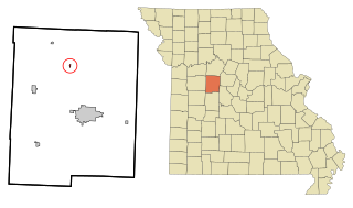
Hughesville is a village in north central Pettis County, Missouri, United States. The population was 183 at the 2010 census.

Evans Mills is a village in Jefferson County, New York, United States. The population was 621 at the 2010 census. The village is within the town of Le Ray and is northeast of Watertown.

<span class="mw-page-title-main">Fort Salonga, New York</span> Hamlet and census-designated place in New York, United States

Fort Salonga is a hamlet and census-designated place (CDP) in the Towns of Huntington and Smithtown in Suffolk County, on the North Shore of Long Island, in New York, United States. The population was 10,008 at the 2010 census.

<span class="mw-page-title-main">Head of the Harbor, New York</span> Village in New York, United States

Head of the Harbor is a village in Suffolk County, on the North Shore of Long Island, New York, United States. The population was 1,472 at the time of the 2010 census.

<span class="mw-page-title-main">Nesconset, New York</span> Hamlet and census-designated place in New York, United States

Nesconset is a hamlet and census-designated place (CDP) located within the Town of Smithtown, in Suffolk County, Long Island, New York, United States. The population was 13,207 at the time of the 2020 census.

<span class="mw-page-title-main">Nissequogue, New York</span> Village in New York, United States

Nissequogue is a village in Suffolk County, on the North Shore of Long Island, in New York, United States. The village population was 1,564 at the 2020 census.

<span class="mw-page-title-main">St. James, New York</span> Hamlet and census-designated place in New York, United States

St. James is a hamlet and census-designated place (CDP) in Suffolk County, New York, United States. The population of the CDP was 13,487 at the 2020 census. St. James is part of the Town of Smithtown and is located on the North Shore of Long Island. The ZIP code is 11780.

<span class="mw-page-title-main">Salesville, Ohio</span> Census-designated place in Ohio, United States

Salesville is a census-designated place and former village in Guernsey County, Ohio, United States. As of the 2020 census, the population was 123, down from 129 at the 2010 census. Its residents voted for dissolution in 2016.

<span class="mw-page-title-main">Tiltonsville, Ohio</span> Village in Ohio, United States

Tiltonsville is a village in southern Jefferson County, Ohio, United States, along the Ohio River. The population was 1,259 at the 2020 census. It is a part of the Weirton–Steubenville metropolitan area.

<span class="mw-page-title-main">Jerusalem, Ohio</span> Village in Ohio, United States

Jerusalem is a village in Monroe County, Ohio, United States. The population was 121 at the 2020 census.

<span class="mw-page-title-main">Continental, Ohio</span> Village in Ohio, United States

Continental is a village in Putnam County, Ohio, United States. The population was 1,102 at the 2020 census.

<span class="mw-page-title-main">Dalton, Ohio</span> Village in Ohio, United States

Dalton is a village in Wayne County, Ohio, United States. The 2020 census indicated a population of 1,927.

<span class="mw-page-title-main">Pike Township, Berks County, Pennsylvania</span> Township in Pennsylvania, United States

Pike Township is a township in Berks County, Pennsylvania, United States. The population was 1,723 at the 2010 census.

<span class="mw-page-title-main">Paddock Lake, Wisconsin</span> Village in Wisconsin, United States

Paddock Lake is a village in Kenosha County, Wisconsin, United States. The population was 2,919 at the 2020 census.

Delhi is a village and the county seat of Delaware County, New York, United States. The population was 3,087 at the 2010 census.

<span class="mw-page-title-main">Riverhead (CDP), New York</span> Hamlet and census-designated place in New York, United States

Riverhead is a census-designated place (CDP) roughly corresponding to the hamlet by the same name located in the Town of Riverhead in Suffolk County, on Long Island, in New York, United States. The CDP's population was 13,299 at the 2010 census.

<span class="mw-page-title-main">Smithtown (CDP), New York</span> Hamlet and census-designated place in New York, United States

Smithtown is a hamlet and census-designated place (CDP) within the Town of Smithtown in Suffolk County, New York. The population was 25,629 at the 2020 census.

<span class="mw-page-title-main">Capitan, New Mexico</span> Village in New Mexico, United States

Capitan is a village in Lincoln County, New Mexico, United States, located north of the Lincoln National Forest between the Capitan and Sacramento Mountains at an elevation of 6,350 feet. The population was 1,489 at the 2010 census. Capitan was founded in the 1890s and incorporated in 1941.

References

  1. 1 2 "Village of The Branch". Suffolk County Village Officials Association. Retrieved August 23, 2010.
  2. "ArcGIS REST Services Directory". United States Census Bureau. Retrieved September 20, 2022.
  3. "Village of the Branch". villageofthebranch.net. Retrieved April 21, 2024.
  4. "Geographic Identifiers: 2010 Demographic Profile Data (G001): Village of the Branch village, New York". U.S. Census Bureau, American Factfinder. Archived from the original on February 12, 2020. Retrieved December 21, 2012.
  5. "Census of Population and Housing". Census.gov. Retrieved June 4, 2015.
  6. 1 2 3 4 "U.S. Census website". United States Census Bureau . Retrieved January 31, 2008.
  7. Robert T. Englert (July 1986). "National Register of Historic Places Registration: Branch Historic District". New York State Office of Parks, Recreation and Historic Preservation . Retrieved February 20, 2010.See also: "Accompanying 15 photos".

Commons-logo.svg Media related to Village of the Branch, New York at Wikimedia Commons