Suffolk County is a predominantly suburban county and is the easternmost county in the U.S. state of New York. As of the 2010 census, the county's population was 1,493,350, estimated to have decreased slightly to 1,476,601 in 2019, making it the fourth-most populous county in New York. Its county seat is Riverhead, though most county offices are in Hauppauge. The county was named after the county of Suffolk in England, from where its earliest European settlers came.

Bayport is a hamlet and census-designated place (CDP) in the Town of Islip, Suffolk County, New York, United States, on Long Island. The population was 8,896 at the 2010 census.
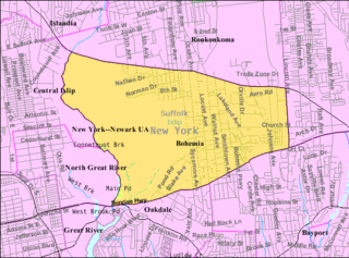
Bohemia is a hamlet in Suffolk County, New York, United States. The population was 10,180 at the 2010 census. It is situated along the South Shore of Long Island in the Town of Islip, approximately 50 miles from New York City.
Cherry Grove is a hamlet in the Town of Brookhaven, Suffolk County, New York, United States. It is located on Fire Island, a barrier island separated from the southern side of Long Island by the Great South Bay. The hamlet has approximately 300 houses on 41 acres (170,000 m2), a summer seasonal population of 2,000 and a year-round population of 15.
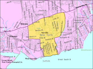
Sayville is a hamlet and census-designated place in Suffolk County, New York, United States. Located on the South Shore of Long Island in the Township of Islip, the population of the CDP was 16,853 at the time of the 2010 census.

West Sayville is a hamlet in Suffolk County, New York, United States. It is also a census-designated place (CDP) and had a population of 5,011 at the 2010 census.

Islip is one of ten towns in Suffolk County, New York (USA). Located on the South Shore of Long Island, the town population was 335,543 at the 2010 census. Within the Town of Islip is a smaller, unincorporated hamlet and census-designated place also named Islip.

The Town of Brookhaven is the most populous of the ten towns of Suffolk County, New York, United States. Part of the New York metropolitan area, it is located approximately 50 miles from Manhattan. It is the only town in the county that stretches from the North Shore to the South Shore of Long Island. It is the largest of New York State's 932 towns by area, and the second most populous after the Town of Hempstead.

Great South Bay, actually a lagoon, is situated between Long Island and Fire Island, in the State of New York. It is approximately 45 miles (72 km) long and has an average depth of 4 foot 3 inches and is 20 feet at its deepest. It is protected from the Atlantic Ocean by Fire Island, a barrier island, as well as the eastern end of Jones Beach Island and Captree Island.

Islip is a hamlet and census-designated place (CDP) that lies within the much larger Town of Islip in Suffolk County, New York. Located on the South Shore of Long Island, the CDP had a population of 18,869 at the time of the 2010 census, a decline of 8% from the 2000 census.

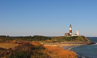
Fire Island is the large center island of the outer barrier islands parallel to the south shore of Long Island, New York. Occasionally, the name is used to refer collectively to not only the central island, but also Long Beach Barrier Island, Jones Beach Island, and Westhampton Island, since the straits which separate these islands are ephemeral. In 2012, Hurricane Sandy once again divided Fire Island into two islands. Together, these two islands are approximately 31 miles (50 km) long and vary between 520 and 1,310 feet wide. Fire Island is part of Suffolk County. It lies within the towns of Babylon, Islip, and Brookhaven, containing two villages and a number of hamlets. All parts of the island not within village limits are part of the Fire Island census-designated place (CDP), which had a permanent population of 292 at the 2010 census, though that expands to thousands of residents and tourists during the summer months.
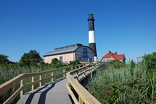
Fire Island National Seashore (FINS) is a United States National Seashore that protects a 26-mile (42 km) section of Fire Island, an approximately 30-mile (48 km) long barrier island separated from Long Island by the Great South Bay. The island is part of New York State's Suffolk County.

Fire Island Pines is a hamlet in the Town of Brookhaven, Suffolk County, New York, United States. It is located on Fire Island, a barrier island on the southern side of Long Island.

The South Shore of Long Island, in the U.S. state of New York, is the area along Long Island's Atlantic Ocean shoreline. Though some consider the South Shore to include parts of Queens, particularly the beach communities in the Rockaways such as Belle Harbor, the term is generally used to refer to the Long Island coastline in Nassau and Suffolk counties. It is often used as a generic name for the entire southern half of Long Island rather than just the area immediately adjacent to the coastline.
The Babylon Rail Road was a horsecar line in Babylon Village, New York, later converted to a trolley line. It was opened in 1871 and ceased operations in 1920.
Davis Park is a hamlet on Fire Island in the Town of Brookhaven in Suffolk County, in the U.S. state of New York, off the South Shore village of Patchogue, Long Island. It lies within the Fire Island National Seashore. Davis Park is commonly used to refer to the business and public part of the community on both sides of Trustees' Walk, in contrast to the sections known as Leja Beach and Ocean Ridge. However, Davis Park is also used to refer to all three areas together, which are contiguous, share services and social life, and are separated from other communities on the island.

Sayville is a station on the Montauk Branch of the Long Island Rail Road in the village of Sayville, New York, on Depot Street between Greeley Avenue and Railroad Avenue. Ferries to Fire Island board from a port south of the station.

Fair Harbor is a small community hamlet located near the western end of Fire Island. It is a part of the Town of Islip on Long Island, New York. With approximately 350 homes within its 13-block town limits, the town features a few stores, a restaurant and a pizza shop, giving it old-style charm with the security of a state-of-the-art Fire Department and EMS. Moreover, the beach is wide, and the bay front is active.
