
Brookhaven National Laboratory (BNL) is a United States Department of Energy national laboratory located in Upton, Long Island a hamlet of the Town of Brookhaven. It was formally established in 1947 at the site of Camp Upton, a former U.S. Army base. Located approximately 60 miles east of New York City, it is managed by Stony Brook University and Battelle Memorial Institute.

Gordon Heights is a hamlet and census-designated place (CDP) in the Town of Brookhaven, Suffolk County, Long Island, New York, United States. The population was 3,981 at the 2020 census.
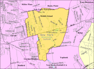
Middle Island is a hamlet and census-designated place (CDP) in the Town of Brookhaven, Suffolk County, New York, United States. The population was 10,483 at the 2010 census. It is situated between the hamlets of Coram and Ridge, to the west and east, respectively, and Rocky Point and Yaphank to the north and south. The name derives from the fact that it lies approximately halfway between the eastern and western ends of Long Island as well as halfway between the northern and southern boundaries.

Ridge is a hamlet and census-designated place (CDP) in the town of Brookhaven, Suffolk County, New York, United States. The population was 13,336 at the 2010 census.

Yaphank is a hamlet and census-designated place (CDP) in Suffolk County, New York, United States. The population was 5,945 at the time of the 2010 census.
Lowville is a town in Lewis County, New York, United States. The population was 4,888 at the 2020 census, down from 4,982 in 2010. The town is near the center of the county and is southeast of the city of Watertown. The town of Lowville contains a village also named Lowville, which is the county seat. The town is named after Nicholas Low, an early landowner. Low was of Dutch descent, and had emigrated with his wife and three small children from a rural village outside Amsterdam in 1778. Despite popular folk etymology, the name Lowville has nothing to do with its low elevation or the lowing cattle of the many nearby dairy farms.

Islip is a town in Suffolk County, New York, United States, on the South Shore of Long Island. The population was 335,543 at the 2010 census, making it the fourth most populous city or town in the New York metropolitan area.

Riverhead is a town in Suffolk County, New York, United States, on the north shore of Long Island. Since 1727, Riverhead has been the county seat of Suffolk County, though most county offices are in Hauppauge. As of the 2020 census, the population was 35,902. The town rests on the mouth of the Peconic River, from which it derives its name. The smaller hamlet of Riverhead lies within it, and is the town's principal economic center. The town is 166 miles (267 km) southwest of Boston via the Orient Point-New London Ferry, and is 76 miles (123 km) northeast of New York City.

Brookhaven, formally the Town of Brookhaven, is a large suburban town in Suffolk County, Long Island, New York. With a population of 488,497 as of 2022, it is the second most populous town in the United States and in New York and the third most populous community in the state.

A severe thunderstorm watch is a statement issued by weather forecasting agencies to advise the public that atmospheric conditions in a given region may lead to the development of severe thunderstorms within the region over several hours. The criteria for issuing a watch varies from country to country and may also include torrential rainfall and tornadoes. A watch may also be issued several hours ahead of the arrival of a mature and organized complex of storms, such as a mesoscale convective system.

The National Weather Service (NWS) is an agency of the United States federal government that is tasked with providing weather forecasts, warnings of hazardous weather, and other weather-related products to organizations and the public for the purposes of protection, safety, and general information. It is a part of the National Oceanic and Atmospheric Administration (NOAA) branch of the Department of Commerce, and is headquartered in Silver Spring, Maryland, within the Washington metropolitan area. The agency was known as the United States Weather Bureau from 1890 until it adopted its current name in 1970.

Camp Upton was a port of embarkation of the United States Army during World War I. It was located in Yaphank, New York in Suffolk County on Long Island, on the present-day location of Brookhaven National Laboratory.

County Route 46 (CR 46) is a major county road in eastern Suffolk County, New York, in the United States. It runs south-to-north from CR 75 in Smith Point County Park to New York State Route 25A (NY 25A) near the border of Shoreham and Wading River. The road is known as the William Floyd Parkway along its entire length, and is named after William Floyd, a Long Island native and a signer of the United States Declaration of Independence. Despite its "parkway" designation within the State of New York, the road is open to commercial vehicles.
The economy of the State of New York is reflected in its gross state product in 2022 of $2.053 trillion, ranking third in size behind the larger states of California and Texas. If New York State were an independent nation, it would rank as the 10th largest economy in the world by nominal GDP. However, in 2019, the multi-state, New York City-centered metropolitan statistical area produced a gross metropolitan product (GMP) of $US2.0 trillion, ranking first nationally by a wide margin and would also rank as the 10th largest GDP in the world.
A significant weather advisory was a hazardous weather statement issued by certain Weather Forecast Offices (WFO) of the National Weather Service (NWS) in the United States to alert the public of thunderstorm activity that is below designated severe criteria for and/or is not expected to produce severe weather. The title assigned to the advisory — alternately titled "significant weather alert" or referenced by its originating product, "special weather statement" — varied by the issuing WFO.

National Weather Service Lincoln, Illinois also known as National Weather Service Central Illinois is a weather forecast office responsible for monitoring weather conditions for 35 counties in Central and Southeastern Illinois. The Central Illinois office initially consisted of two forecast offices in Peoria and Springfield until the current location in Lincoln became the sole local forecast office in 1995. Federal meteorology offices and stations in the region date back to the 19th century when the Army Signal Service began taking weather observations using weather equipment at the Springer Building in Springfield. Since that time the presence of the National Weather Service greatly increased with the installation of new weather radars, stations and forecast offices. The current office in Lincoln maintains a WSR-88D (NEXRAD) radar system, and Advanced Weather Interactive Processing System (AWIPS) that greatly improve forecasting in the region. Lincoln is in charge of weather forecasts, warnings and local statements as well as aviation weather.
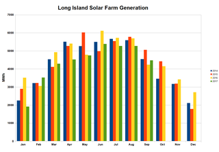
The 32 megawatt AC Long Island Solar Farm (LISF), located in Upton, New York, was the largest photovoltaic array in the eastern U.S. in November 2011. The LISF is made up of 164,312 solar panels from BP Solar which provide enough electricity for roughly 4,500 households. The project will cause the abatement of more than 30,000 metric tons of carbon dioxide emissions per year. LISF is co-owned by BP Solar and MetLife through Long Island Solar Farm LLC. Municipal utility Long Island Power Authority (LIPA) buys the 37-megawatt (49,600 hp) power plant's output, which is estimated at 44 GWh annually, under a 20-year power purchase agreement (PPA). Payments over that time are expected to total $298 million. The project was engineered by Blue Oak Energy and construction subcontracted to Hawkeye LLC from Hauppauge, New York. The plant earned the Best Photovoltaic Project of Year Award from the New York Solar Energy Industries Association. The panels are mounted at a fixed tilt angle of 35°, with the rows spaced approximately 18 ft 4 in (5.59 m) apart.
The National Weather Service Boston/Norton, Massachusetts, is a local office of the National Weather Service (NWS), run under the auspices of the NWS's Eastern Region. This weather forecast office (WFO) is responsible for monitoring weather conditions throughout most of southern New England. The southern New England weather forecast office provides warning and forecast services for most of Massachusetts, Northern Connecticut, and all of Rhode Island. Besides public weather services, WFO Norton (BOX) provides marine, aviation, fire weather, and hydrological forecast services. Additional hydrologic information is provided by the co-located Northeast River Forecast Center (NERFC).
National Weather Service - Pleasant Hill/Kansas City, Missouri is a Weather Forecast Office (WFO) of the National Weather Service, which is responsible for forecasts and the dissemination of weather warnings and advisories for 37 counties in northern and western Missouri and seven counties in extreme eastern Kansas, including the Kansas City and St. Joseph metropolitan areas. Though, as the Storm Prediction Center (SPC) in Norman, Oklahoma is responsible for issuing severe thunderstorm and tornado watches, the Pleasant Hill/Kansas City WFO only composes outline and status updates for SPC-issued watches affecting any portion of its designated County Warning Area.

