Ohio, New York

Last updated

Ohio, New York
Ohio Herkimer NY.png
Location within Herkimer County
USA New York location map.svg
Red pog.svg
Ohio
Usa edcp location map.svg
Red pog.svg
Ohio
Coordinates: 43°25′31″N74°56′39″W / 43.42528°N 74.94417°W / 43.42528; -74.94417
CountryUnited States
State New York
County Herkimer
Government
  Type Town Council
   Town Supervisor Scott Bagetis (R)
   Town Council
Members' List
Area
[1]
  Total307.57 sq mi (796.60 km2)
  Land301.33 sq mi (780.44 km2)
  Water6.24 sq mi (16.16 km2)
Elevation
2,119 ft (646 m)
Population
 (2010)
  Total1,002
  Estimate 
(2016) [2]
1,003
  Density3.33/sq mi (1.29/km2)
Time zone UTC-5 (Eastern (EST))
  Summer (DST) UTC-4 (EDT)
ZIP code
13324
Area code 315
FIPS code 36-043-54507
GNIS feature ID0979302
Website ohiony.us

Ohio is a town in Herkimer County, New York, United States. The population was 1,002 at the 2010 census. [3] The town is named after the state of Ohio. [4] The town is in the northern part of the county and northeast of Utica. Part of Ohio is within the Adirondack Park.

Contents

History

The town of Ohio was established as the town of West Brunswick in 1823 from part of the town of Norway. The name was changed to Ohio in 1836. Ohio was increased by some of the now-defunct town of Wilmurt, which itself had been partly formed with territory from Ohio and the town of Russia in 1836. Wilmurt was once the largest town in New York.

Geography

According to the United States Census Bureau, the town has a total area of 307.6 square miles (796.6 km2), of which 301.4 square miles (780.5 km2) are land and 6.2 square miles (16.1 km2), or 2.02%, are water. [3]

The eastern town line is the border of Hamilton County, and the western town line is the border of Oneida County.

West Canada Creek, a tributary of the Mohawk River, crosses the town from east to west, entering the Hinckley Reservoir near the western town border. The South Branch of the Moose River, part of the St. Lawrence River watershed, crosses the northern end of the town from east to west.

New York State Route 8 is a north–south highway in Ohio. New York State Route 365 runs along the north side of West Canada Creek before intersecting NY-8.

Demographics

Historical population
CensusPop.Note
1830 713
1840 692−2.9%
1850 1,05151.9%
1860 1,1358.0%
1870 1,009−11.1%
1880 961−4.8%
1890 832−13.4%
1900 660−20.7%
1910 527−20.2%
1920 58310.6%
1930 457−21.6%
1940 4600.7%
1950 54718.9%
1960 480−12.2%
1970 468−2.5%
1980 78868.4%
1990 88011.7%
2000 9224.8%
2010 1,0028.7%
2016 (est.)1,003 [2] 0.1%
U.S. Decennial Census [5]

As of the census of 2000, [6] there were 922 people, 349 households, and 255 families residing in the town. The population density was 3.0 people per square mile (1.2/km2). There were 974 housing units at an average density of 3.2 per square mile (1.2/km2). The racial makeup of the town was 96.96% White, 0.54% African American, 1.41% Native American, 0.11% Asian, 0.54% from other races, and 0.43% from two or more races. Hispanic or Latino of any race were 0.54% of the population.

There were 349 households, out of which 35.2% had children under the age of 18 living with them, 60.7% were married couples living together, 8.0% had a female householder with no husband present, and 26.9% were non-families. 20.9% of all households were made up of individuals, and 6.6% had someone living alone who was 65 years of age or older. The average household size was 2.64 and the average family size was 3.06.

In the town, the population was spread out, with 26.7% under the age of 18, 6.8% from 18 to 24, 29.0% from 25 to 44, 27.3% from 45 to 64, and 10.2% who were 65 years of age or older. The median age was 38 years. For every 100 females, there were 104.9 males. For every 100 females age 18 and over, there were 107.4 males.

The median income for a household in the town was $29,813, and the median income for a family was $36,667. Males had a median income of $25,625 versus $22,153 for females. The per capita income for the town was $13,641. About 18.7% of families and 20.9% of the population were below the poverty line, including 26.2% of those under age 18 and 30.7% of those age 65 or over.

Communities and locations in Ohio

Communities and inhabited locations

Geographical and similar locations

See also

Related Research Articles

<span class="mw-page-title-main">Arietta, New York</span> Town in New York, United States

Arietta is a town in Hamilton County, New York, United States. The population was 304 at the 2010 census. The town was named after the mother of one of the first settlers, Rensselaer Van Rennslaer.

<span class="mw-page-title-main">Benson, New York</span> Town in New York, United States

Benson is a town in Hamilton County, New York, United States. The population was 221 at the 2020 census. The town is on the southern border of Hamilton County and is northwest of Schenectady. The current Town Supervisor is John M. Stortecky.

<span class="mw-page-title-main">Indian Lake, New York</span> Town in New York, United States

Indian Lake is a town in Hamilton County, New York, United States. The population was 1,352 at the 2010 census. The name is from a lake of the same name that is largely inside the town. There are no permanent stop lights in the town. Law enforcement is provided by New York State Troopers and Hamilton County Sheriff's Office.

<span class="mw-page-title-main">Long Lake, New York</span> Town in New York, United States

Long Lake is a town in Hamilton County, New York, United States. The population was 791 at the 2020 census.

<span class="mw-page-title-main">Morehouse, New York</span> Town in New York, United States

Morehouse is a town in Hamilton County, New York, United States. The population was 92 at the 2020 census. The name is that of an early developer, Andrew K. Morehouse.

<span class="mw-page-title-main">Columbia, New York</span> Town in New York, United States

Columbia is a town in Herkimer County, New York, United States. As of the 2020 census, the town population was 1,569. The town is at the southern border of the county and is southeast of Utica.

<span class="mw-page-title-main">Litchfield, New York</span> Town in New York, United States

Litchfield is a town in Herkimer County, New York, United States. The population was 1,513 at the 2010 census. The town is named after Litchfield, Connecticut, the source of some early settlers of the city.

<span class="mw-page-title-main">Russia, New York</span> Town in New York, United States

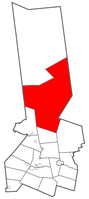
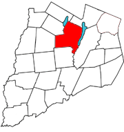
Russia is a town in Herkimer County, New York, United States. The population was 2,269 at the 2020 census, down from 2,587 in 2010. The town is located in the northwestern part of the county and is northeast of Utica.

<span class="mw-page-title-main">Salisbury, Herkimer County, New York</span> Town in New York, United States

Salisbury is a town in Herkimer County, New York, United States. The population was 1,958 at the 2010 census. The town is on the eastern edge of the county, north of the city of Little Falls. The northern part of the town is in the Adirondack Park.

<span class="mw-page-title-main">Warren, New York</span> Town in Herkimer County, New York, US

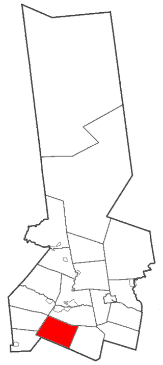
Warren is a town in Herkimer County, New York, United States. The population was 1,143 at the 2010 census. The town is named after General Joseph Warren, who was killed at the Battle of Bunker Hill. Warren is in the south part of Herkimer County. US 20 passes across the town.

<span class="mw-page-title-main">Webb, New York</span> Town in New York, United States

Webb is the northernmost town in Herkimer County, New York, United States. As of the 2010 census it had a population of 1,807.

<span class="mw-page-title-main">Western, New York</span> Town in New York, United States

Western is a town in Oneida County, New York, United States. The population was 1,951 at the 2010 census.

<span class="mw-page-title-main">Otsego, New York</span> Town in New York, United States

Otsego is a town in the north-central part of Otsego County, New York, United States. The population was 3,641 at the 2020 census. The town is named after Lake Otsego, which forms part of the town's eastern border.

<span class="mw-page-title-main">Richfield, New York</span> Town in Otsego County, New York, US

Richfield is a town located in Otsego County, New York, United States. As of the 2010 census, the town had a population of 2,388. The Town of Richfield is located at the northern border of the county.

<span class="mw-page-title-main">Springfield, New York</span> Town in New York, United States

Springfield is a town in Otsego County, New York, United States. The population was 1,358 at the 2010 census.

Worcester is a town in Otsego County, New York, United States. The population was 2,220 at the 2010 census. Worcester is on the southeastern border of the county and is northeast of Oneonta. The Worcester Central School District presently has 369 students enrolled in grades K-12.

<span class="mw-page-title-main">Johnsburg, New York</span> Town in New York, United States

Johnsburg is a town in the northwestern corner of Warren County, New York, United States. It is part of the Glens Falls Metropolitan Statistical Area. The town population was 2,143 at the 2020 census. The town is named after John Thurman, an early settler and founder. Johnsburg is the largest town in Warren County by area.

<span class="mw-page-title-main">Herkimer, New York</span> Town in New York, United States

Herkimer is a town in Herkimer County, New York, United States, southeast of Utica. It is named after Nicholas Herkimer. The population was 9,566 at the 2020 census, down from 10,175 in 2010.

<span class="mw-page-title-main">Milford, New York</span> Town in New York, United States

Milford is a town in Otsego County, New York, United States. The population was 3,044 at the 2010 census. Within town is the village of Milford. The town is northeast of the City of Oneonta.

<span class="mw-page-title-main">West Canada Creek</span> River in New York, United States

The West Canada Creek is a 76-mile-long (122 km) river in upstate New York, United States. West Canada Creek is an important water way in Hamilton, Oneida, and Herkimer counties, draining the south part of the Adirondack Mountains before emptying into the Mohawk River near the Village of Herkimer. The name "Canada" is derived from an Iroquoian word for "village" (Kanata).

References

  1. "2016 U.S. Gazetteer Files". United States Census Bureau. Retrieved July 5, 2017.
  2. 1 2 "Population and Housing Unit Estimates" . Retrieved June 9, 2017.
  3. 1 2 "Geographic Identifiers: 2010 Census Summary File 1 (G001): Ohio town, Herkimer County, New York". American Factfinder. U.S. Census Bureau. Archived from the original on February 13, 2020. Retrieved November 30, 2017.
  4. "Towns named after states". Reading Eagle. July 2, 1897. p. 3. Retrieved October 14, 2015.
  5. "Census of Population and Housing". Census.gov. Retrieved June 4, 2015.
  6. "U.S. Census website". United States Census Bureau . Retrieved January 31, 2008.