Remsenburg is a hamlet located in the Town of Southampton, Suffolk County, Long Island, New York, United States.
Contents
There are no stoplights and very few commercial businesses.
Remsenburg is a hamlet located in the Town of Southampton, Suffolk County, Long Island, New York, United States.
There are no stoplights and very few commercial businesses.
As early as 1712, meadows in Speonk were leased to cattle-owners from Southampton. Most of the early settlers of Speonk came west from Southampton and Bridgehampton in the 1740s to clear the forests and build farms. During the 1880s, duck farms thrived in Speonk, but few survived past the turn of the century.
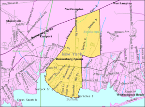
The name Speonk was inspired by a Native American word meaning high place. An 1897 Long Island Rail Road catalog listed Speonk, noting that that name "certainly sounds like the call of a frog." Some residents pressed to change the name to Remsenburg, to honor a prominent resident, Charles Remsen, who had donated a new Presbyterian Church. Today, both names remain in use, each covering different areas of the community. The area close to the bay is called Remsenburg, and the more bucolic inland area is still called Speonk.
During the twentieth century, its most famous resident was the English writer P.G. Wodehouse. He wrote many of the escapades of Bertie Wooster and his manservant, Jeeves, from a home on Basket Neck Lane in Remsenburg. Other residents of note include the songwriter Frank Loesser, who wrote for Broadway shows including Guys and Dolls ; the playwright Guy Bolton, who collaborated with Wodehouse on Anything Goes; Marvel Comics editor Stan Lee; Sandy Becker, a New York children's television host, Dave Garroway, the original host of NBC's Today Show when it first aired in January 1952, and Leo-Arthur Kelmenson, advertising executive known for his association with Lee Iacocca and his advertising campaign for Chrysler. Remsenburg is an exclusive area, and many well known actress/actors/playwrights/directors live in this hamlet of Southampton.
Remsenburg is located at geographic coordinates 40° 48' 28" North, 72° 42' 32" West (40.807709, -72.708923). As Remsenberg is located within the Town of Southampton, County of Suffolk, and is in on the Atlantic Ocean and bay, it is considered to be geographically, historically, and culturally part of the Hamptons.
40°48′28″N72°42′32″W / 40.807709°N 72.708923°W
| International | |
|---|---|
| National | |

Suffolk County is the easternmost county in the U.S. state of New York. It comprises the eastern two-thirds of Long Island, bordered to its west by Nassau County, to its east by Gardiners Bay and the Atlantic Ocean, to its north by Long Island Sound, and to its south by Great South Bay.

Eastport is a hamlet and census-designated place (CDP) in Suffolk County, New York, on the South Shore of Long Island. The population was 1,831 at the 2010 census.

Hampton Bays is a hamlet and census-designated place (CDP) in the Town of Southampton in Suffolk County, on Long Island, in New York. It is considered as part of the region of Long Island known as The Hamptons. The population was 13,603 at the 2010 census.

Remsenburg-Speonk is a census-designated place (CDP) located in the Town of Southampton, Suffolk County, New York, United States. It consists of the hamlets of Remsenburg and Speonk. The population was 2,642 at the 2010 census. The population of this CDP and surrounding ones increases in the summer due to summer renters who come out for the beaches and scenery.

West Hampton Dunes is an incorporated village in the Town of Southampton on Westhampton Island, in Suffolk County, in New York, United States, off the South Shore of Long Island. The population was 55 at the 2010 census.
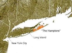
The Hamptons, part of the East End of Long Island, consist of the towns of Southampton and East Hampton, which together comprise the South Fork of Long Island, in Suffolk County, New York. The Hamptons are a popular seaside resort and one of the historical summer colonies of the northeastern United States.

Southampton is an incorporated village in the Town of Southampton in Suffolk County, on the South Fork of Long Island, in New York, United States. The population was 3,109 at the 2010 census.

Southampton, officially the Town of Southampton, is a town in southeastern Suffolk County, New York, partly on the South Fork of Long Island. As of the 2020 U.S. census, the town had a population of 69,036. Southampton is included in the stretch of shoreline prominently known as the Hamptons.
Speonk is a hamlet located in the Town of Southampton, Suffolk County, New York, United States.

Fire Island is the large center island of the outer barrier islands parallel to the South Shore of Long Island, in the U.S. state of New York.

The Town of East Hampton is located in southeastern Suffolk County, New York, at the eastern end of the South Shore of Long Island. It is the easternmost town in the state of New York. At the time of the 2020 United States census, it had a total population of 28,385.

Peconic County is a proposed new county on Long Island in the U.S. state of New York that would secede the five easternmost towns of Suffolk County: East Hampton, Riverhead, Shelter Island, Southampton and Southold, plus the Shinnecock Indian Reservation.
Montauk Highway is an east–west road extending for 95 miles (153 km) across the southern shore of Long Island in Suffolk County, New York, in the United States. It extends from the Nassau County line in Amityville, where it connects to Merrick Road, to Montauk Point State Park at the very eastern end of Long Island in Montauk. The highway is known by several designations along its routing, primarily New York State Route 27A (NY 27A) from the county line to Oakdale and NY 27 east of Southampton. The portion of Montauk Highway between Oakdale and Southampton is mostly county-maintained as County Route 80 and County Route 85.

The North Fork is a 30-mile- (48 km) long peninsula in the northeast part of Suffolk County, New York, U.S., roughly parallel with a longer peninsula known as the South Fork, both on the East End of Long Island. Although the peninsula begins east of Riverhead hamlet, the term North Fork can also refer collectively to the towns of Riverhead and Southold in their entirety.

New York's 1st congressional district is a congressional district for the United States House of Representatives in eastern Long Island. It includes the eastern two-thirds of Suffolk County, including the northern portion of Brookhaven, as well as the entirety of the towns of Huntington, Smithtown, Riverhead, Southold, Southampton, East Hampton, and Shelter Island. The district encompasses extremely wealthy enclaves such as the Hamptons, middle class suburban towns such as Selden, Centereach and Lake Grove, working-class towns such as Riverhead and rural farming communities such as Mattituck and Jamesport on the North Fork. The district currently is represented by Republican Nick LaLota who lives in Amityville, outside of the district.
The Outer Barrier, also known as the Long Island and New York City barrier islands, refers to the string of barrier islands that divide the lagoons south of Long Island, New York from the Atlantic Ocean. These islands include Long Beach Barrier Island, Barnum Island, Jones Beach Island, Fire Island and Westhampton Island. The outer barrier extends 75 miles (121 km) along the South Shore of Long Island, from the Rockaway Peninsula in New York City to the east end of Shinnecock Bay in Suffolk County.

Speonk is an unmanned railroad station on the Montauk Branch of the Long Island Rail Road. It is located on Phillips Avenue at Depot Road in Speonk, New York, just north of Montauk Highway. The station has two parking lots, one operated by the Long Island Rail Road, and the other operated by the Town of Southampton, both of which are free. It also lies adjacent to one of the largest railroad yards on Long Island's East End. This yard is mostly used to hold passenger consists, as a handful of trains terminate at Speonk rather than continue all the way to Montauk.

The East End of Long Island is constituted by the five townships at the eastern end of New York's Suffolk County, namely Riverhead, Southampton, Southold, Shelter Island, and East Hampton. Long Island's North Fork and South Fork are part of the East End. "The East End" is sometimes shortened as "The End", but this latter term is also applied only to Montauk, the most easterly hamlet of the contiguous land mass.