The Great Appalachian Valley, also called The Great Valley or Great Valley Region, is one of the major landform features of eastern North America. It is a gigantic trough, including a chain of valley lowlands, and the central feature of the Appalachian Mountains system. The trough stretches about 1,200 miles (1,900km) from Quebec in the north to Alabama in the south and has been an important north–south route of travel since prehistoric times.
The Great Valley marks the eastern edge of the Ridge and Valleyphysiographic province. There are many regional names of the Great Valley, such as the Shenandoah Valley. From a large perspective the Great Valley can be divided into a northern section and a southern section.
The southern Great Valley is bounded on the east by the Blue Ridge physiographic province, which includes, from north to south, South Mountain in Pennsylvania and Maryland, the Blue Ridge of Virginia, Holston Mountain in Tennessee, and the Unaka Range and the Great Smoky Mountains of Tennessee and North Carolina. A gap in these mountains exists near Roanoke, Virginia. Other gaps of note in the Blue Ridge of Virginia, connecting the Piedmont region with the Great Valley, include Thornton Gap, Swift Run Gap, and Rockfish Gap.
Routes through the valley were first used by Native Americans. In pre-colonial and the early colonial era, a major Indian pathway through the Great Valley was known as the Great Indian Warpath, Seneca Trail, and various other names.
The various gaps connecting the Great Valley to lands to the east and west have played important roles in American history. On the east side, the wide gap in southeast Pennsylvania became the main route for colonization of the Great Valley. By the 1730s, the Pennsylvanian Great Valley west of South Mountain was open to settlement after treaty cessions and purchases from the Indians. The region drew a steady and growing stream of immigrants and became known as "the best poor man's country". European immigrants ultimately thoroughly settled the Great Valley in Pennsylvania and were rapidly migrating and settling southwards into the Shenandoah Valley of Virginia. The entire region between southeast Pennsylvania and the Shenandoah Valley soon became famous as a breadbasket, the most productive mixed farming region in America (Meinig, 1986:134). The road from Philadelphia west to the valley and then south through it became very heavily used and known variously as the Great Wagon Road, the Philadelphia Wagon Road, and the Valley Road. The Conestoga wagon was developed around 1725 in the area of the wide opening between Philadelphia and the Great Valley. The Conestoga wagon became the main vehicle for transportation through the Great Valley until the railroad era.
Culver Gap near Culver's Lake in Sussex County, New Jersey, was an important route through the Kittatinny Mountain from about 10,000 years ago to present. The gap is more than 400 feet (120m) below the top of the mountain. Lenape Native Americans used the gap to hunt and trade on both sides of the mountain. Early settlers from Pennsylvania used the water drop from Culvers Lake to Branchville for a wide assortment of mills. Turnpikes followed the route of Lenape trails through the gap.
By the 1750s, the Great Valley was well-settled to the southern end of the Shenandoah Valley. Immigrants continued to travel from the Philadelphia area south through the Great Valley beyond Shenandoah, to the vicinity of present-day Roanoke, Virginia. There is a wide gap in the Blue Ridge near Roanoke. A branch of the Great Wagon Road began there, crossing through the gap east into the Piedmont region of North Carolina and South Carolina. This road became known as the Carolina Road. During the 1750s, the stream of migrants traveling south through the valley and into the Carolina Piedmont grew into a flood. At the time, the Carolina Piedmont region offered some of the best land at the lowest prices. A string of towns appeared, including Salisbury, Salem, and Charlotte in North Carolina. In the decades before the American Revolution, the Piedmont "upcountry" of the Carolinas was quickly settled, mostly by recent immigrants who migrated from the north to the south via the Great Valley. Many of these immigrants were Scots-Irish, Germans from the Rhineland-Palatinate area, and Moravians. This upcountry population soon surpassed the older and more established lowcountry population near the Atlantic coast, causing serious geopolitical tensions in the Carolinas during the late 18th century (Meinig, 1986: 291–293).
On the west side, the Cumberland Gap became the main route for migration west from the southern Great Valley to Kentucky and Tennessee. In the north, the Mohawk Valley became a major route for westward expansion, especially after the construction of the Erie Canal, which linked New York City in the east to the Great Lakes region in the Midwest via the Hudson River of the Great Valley and the Mohawk Valley gap.
The Great Valley, especially Shenandoah Valley, played an important role during the American Civil War, including its Blue Ridge gaps and nearby Piedmont area and its northward extension to Gettysburg, Pennsylvania, where the bloodiest and most influential Civil War battle was fought in the Battle of Gettysburg from July 1 to July 3, 1863. The Battle of Gettysburg resulted in over 50,000 casualties, but the Union Army victory under the command of Major General George Meade over General Robert E. Lee's Confederate Army forces turned the war in the Union's favor.
In the northern valley, the thoroughfares vary. Heading northeast from Harrisburg, I-81 traces the valley to Swatara Gap, then swings north across Blue Mountain and leaves the valley en route to Scranton. I-78 then continues the route through the valley parallel to the southern slopes of Blue Mountain, connecting Harrisburg with Lebanon, Kutztown, and Allentown. At Allentown, I-78 then swings away south into the hills of the Reading Prong en route to New York City. From Allentown into New Jersey and southern New York, the valley is not traced by an interstate highway, though it is traversed at length (and at oblique angles) by both I-80 and I-84, as well as by the Delaware River between Easton, Pennsylvania, and the Delaware Water Gap.
In New Jersey and New York, the valley gradually bends from the northeast to the north, and starting near Newburgh just beyond the Hudson Highlands, I-87 runs much of the valley's length into Canada, passing Poughkeepsie, Albany, and Glens Falls. In an east–west section of the valley, I-90 traverses the Mohawk Valley towards Utica. North of Glens Falls, I-87 runs west of the valley through the Adirondack Mountains, though it descends back into the valley near Plattsburgh. At the Canada–US border, I-87 becomes Autoroute 15 and continues north to Montreal. No interstate highway crosses the rugged section of the valley east of Lake George or passes through the agriculturally rich Champlain Valley running north to Burlington, Vermont.
Heading north from Burlington, however, along the east side of Lake Champlain, I-89 runs through the valley's northernmost stretches to the Canada–US border, where it becomes Quebec Route 133 and Autoroute 35, which trace the route of the Richelieu River in its southern section, where the Great Valley finally dissipates into the plain of the Saint Lawrence River to the east of Montreal. (The Richelieu River continues northward across the plain and empties into the Saint Lawrence to the northeast of Montreal.)
Culture
The Great Valley, especially the southern-middle portion, is within the region known as Appalachia.
↑ Mean monthly maxima and minima (i.e. the expected highest and lowest temperature readings at any point during the year or given month) calculated based on data at said location from 1981 to 2010.
↑ According to the National Weather Service, the snowfall data has been readjusted as of June3,2015[update]. As such, snowfall data is based the source at Albany Snowfall Normals
↑ Official records for Albany kept January 1874 to May 1938 at downtown and at Albany Int'l since June 1938. For more information, see Threadex
↑ Mean monthly maxima and minima (i.e. the expected highest and lowest temperature readings at any point during the year or given month) calculated based on data at said location from 1981 to 2010.
↑ Official records for Knoxville kept January 1871 to February 1942 at downtown and at McGhee Tyson Airport since March 1942. For more information, see Threadex
Drake, Richard B. (2001), A History of Appalachia. Lexington: The University Press of Kentucky. ISBN0-8131-2169-8
Kercheval, Samuel (1850), A History of the Valley of Virginia, Woodstock, Virginia – History (much of it anecdotal) of the colonial Virginia northern frontier
The Shenandoah Valley is a geographic valley and cultural region of western Virginia and the Eastern Panhandle of West Virginia in the United States. The Valley is bounded to the east by the Blue Ridge Mountains, to the west by the eastern front of the Ridge-and-Valley Appalachians, to the north by the Potomac River, to the south by the James River, and to the Southwest by the New River Valley. The cultural region covers a larger area that includes all of the Valley plus the Virginia Highlands to the west and the Roanoke Valley to the south. It is physiographically located within the Ridge and Valley Province and is a portion of the Great Appalachian Valley.
The Blue Ridge Parkway is a National Parkway and All-American Road in the United States, noted for its scenic beauty. The parkway, which is the longest linear park in the U.S., runs for 469 miles (755 km) through 29 counties in Virginia and North Carolina, linking Shenandoah National Park to Great Smoky Mountains National Park. It runs mostly along the spine of the Blue Ridge, a major mountain chain that is part of the Appalachian Mountains. Its southern terminus is at U.S. Route 441 (US 441) on the boundary between Great Smoky Mountains National Park and the Qualla Boundary of the Eastern Band of Cherokee Indians in North Carolina, from which it travels north to Shenandoah National Park in Virginia. The roadway continues through Shenandoah as Skyline Drive, a similar scenic road which is managed by a different National Park Service unit. Both Skyline Drive and the Virginia portion of the Blue Ridge Parkway are part of Virginia State Route 48 (SR 48), though this designation is not signed.
The Blue Ridge Mountains are a physiographic province of the larger Appalachian Highlands range. The mountain range is located in the Eastern United States and extends 550 miles southwest from southern Pennsylvania through Maryland, West Virginia, Virginia, North Carolina, South Carolina, Tennessee, and Georgia. The province consists of northern and southern physiographic regions, which divide near the Roanoke River gap. To the west of the Blue Ridge, between it and the bulk of the Appalachians, lies the Great Appalachian Valley, bordered on the west by the Ridge and Valley province of the Appalachian range.
The Ridge-and-Valley Appalachians, also called the Ridge and Valley Province or the Valley and Ridge Appalachians, are a physiographic province of the larger Appalachian Highlands division. The physiographic province is divided into three sections: the Hudson Valley, the Central, and the Tennessee.
The Roanoke River runs 410 miles (660 km) long through southern Virginia and northeastern North Carolina in the United States. A major river of the southeastern United States, it drains a largely rural area of the coastal plain from the eastern edge of the Appalachian Mountains southeast across the Piedmont to Albemarle Sound. An important river throughout the history of the United States, it was the site of early settlement in the Virginia Colony and the Carolina Colony. An 81-mile (130 km) section of its lower course in Virginia between the Leesville Lake and Kerr Lake is known as the Staunton River, pronounced, as is the Shenandoah Valley city of that name. It is impounded along much of its middle course to form a chain of reservoirs.
There are many historic trails and roads in the United States which were important to the settlement and development of the United States including those used by American Indians.
The Wilderness Road was one of two principal routes used by colonial and early national era settlers to reach Kentucky from the East. Although this road goes through the Cumberland Gap into southern Kentucky and northern Tennessee, the other is sometimes called the "Cumberland Road" because it started in Fort Cumberland in Maryland. Despite Kentucky Senator Henry Clay's advocacy of this route, early in the 19th century, the northern route was selected for the National Road, connecting near Washington, Pennsylvania into the Ohio Valley of northern Kentucky and Ohio.
Valley Pike or Valley Turnpike is the traditional name given for the Indian trail and roadway which is now approximated by U.S. Route 11 in the Shenandoah Valley of Virginia.
Ashby Gap, more commonly known as Ashby's Gap is a wind gap in the Blue Ridge Mountains on the border of Clarke County, Loudoun County and Fauquier County in Virginia. The gap is traversed by U.S. Route 50. The Appalachian trail also passes across the gap.
The Roanoke Valley in southwest Virginia is an area adjacent to and including the Roanoke River between the Blue Ridge Mountains to the east and the Appalachian Plateau to the west. The valley includes much of Roanoke County, as well as the two independent cities of Roanoke and Salem.
The Great Wagon Road was an improved trail through the Great Appalachian Valley from Pennsylvania to North Carolina, and from there to Georgia in colonial America.
U.S. Route 421 (US 421) is a part of the U.S. Highway System that runs from Fort Fisher, North Carolina to Michigan City, Indiana. In Virginia, the U.S. Highway runs 69.23 miles (111.41 km) from the Tennessee state line between the twin cities of Bristol, Tennessee and Bristol, Virginia north and west to the Kentucky state line near St. Charles. Between its endpoints, US 421 has lengthy concurrencies with US 23 and US 58 during its course through Bristol, Weber City, Gate City, Duffield, and Pennington Gap in Southwest Virginia.
The Appalachian National Scenic Trail spans 14 U.S. states over its roughly 2,200 miles (3,500 km): Georgia, North Carolina, Tennessee, Virginia, West Virginia, Maryland, Pennsylvania, New Jersey, New York, Connecticut, Massachusetts, Vermont, New Hampshire, and Maine. The southern end is at Springer Mountain, Georgia, and it follows the ridgeline of the Appalachian Mountains, crossing many of its highest peaks and running almost continuously through wilderness before reaching the northern end at Mount Katahdin, Maine.
U.S. Route 33 is a part of the U.S. Highway System that runs from Elkhart, Indiana to Richmond, Virginia. In Virginia, the U.S. Highway runs 135.60 miles (218.23 km) from the West Virginia state line near Rawley Springs east to its eastern terminus at SR 33 in Richmond. US 33 is the primary east–west highway of Rockingham County, which lies in the Shenandoah Valley. The highway connects the independent city of Harrisonburg, the town of Elkton, and an entrance to Shenandoah National Park. East of the Blue Ridge Mountains, US 33 connects the Piedmont communities of Stanardsville, Gordonsville, and Louisa. The U.S. Highway is a major suburban and urban route in the Richmond metropolitan area. Within Richmond, US 33 runs concurrently with US 250. SR 33 continues from US 33's eastern terminus as a state-numbered extension of the U.S. Highway that connects Richmond with Virginia's Middle Peninsula.
The Great Indian Warpath (GIW)—also known as the Great Indian War and Trading Path, or the Seneca Trail—was that part of the network of trails in eastern North America developed and used by Native Americans which ran through the Great Appalachian Valley. The system of footpaths extended from what is now upper New York to deep within Alabama. Various Native peoples traded and made war along the trails, including the Catawba, numerous Algonquian tribes, the Cherokee, and the Iroquois Confederacy. The British traders' name for the route was derived from combining its name among the northeastern Algonquian tribes, Mishimayagat or "Great Trail", with that of the Shawnee and Delaware, Athawominee or "Path where they go armed".
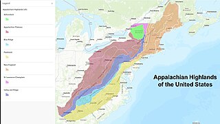
The Appalachian Highlands is one of eight government-defined physiographic divisions of the contiguous United States. The links with the Appalachian Uplands in Canada to make up the Appalachian Mountains. The Highlands includes seven physiographic provinces, which is the second level in the physiographic classification system in the United States. At the next level of physiographic classification, called section/subsection, there are 20 unique land areas with one of the provinces having no sections.
The Carolina Road or the "Old Carolina Road" are names for various sections of the Great Wagon Road and other routes in colonial America. "The 'Old Carolina Road', extending from Lancaster, Pennsylvania to the Yadkin Valley, was one of the most heavily traveled roads in eighteenth century America." Parts of the 180-mile-long (290 km) Journey Through Hallowed Ground National Heritage Area scenic byway follow the Old Carolina Road through Pennsylvania, Maryland and Virginia.
Blair Gap, one of the gaps of the Allegheny, is a water gap along the eastern face atop the Allegheny Front escarpment. Like other gaps of the Allegheny, the slopes of Blair Gap were amenable to foot travel, pack mules, and possibly wagons allowing Amerindians, and then, after about 1778–1780 settlers, to travel west into the relatively depopulated Ohio Country decades before the railroads were born and tied the country together with steel.
The gaps of the Allegheny, meaning gaps in the Allegheny Ridge in west-central Pennsylvania, is a series of escarpment eroding water gaps along the saddle between two higher barrier ridge-lines in the eastern face atop the Allegheny Ridge or Allegheny Front escarpment. The front extends south through Western Maryland and forms much of the border between Virginia and West Virginia, in part explaining the difference in cultures between those two post-Civil War states. While not totally impenetrable to daring and energetic travelers on foot, passing the front outside of the water gaps with even sure footed mules was nearly impossible without navigating terrain where climbing was necessary on slopes even burros would find extremely difficult.
This page is based on this Wikipedia article Text is available under the CC BY-SA 4.0 license; additional terms may apply. Images, videos and audio are available under their respective licenses.