Related Research Articles

Fairfield County is a county in the southwestern corner of the U.S. state of Connecticut. It is the most populous county in the state and was also its fastest-growing from 2010 to 2020. As of the 2020 census, the county's population was 957,419, representing 26.6% of Connecticut's overall population. The closest to the center of the New York metropolitan area, the county contains four of the state's top 7 largest cities—Bridgeport (1st), Stamford (2nd), Norwalk (6th), and Danbury (7th)—whose combined population of 433,368 is nearly half the county's total population.

New London County is in the southeastern corner of Connecticut and comprises the Norwich-New London, Connecticut Metropolitan Statistical Area, which is also included in the Hartford-East Hartford, Connecticut Combined Statistical Area. There is no county government and no county seat, as is the case with all eight of Connecticut's counties; towns are responsible for all local government activities, including fire and rescue, snow removal, and schools.
Scouting in Connecticut has experienced many organizational changes since 1910. With only eight counties, Connecticut has had 40 Boy Scout Councils since the Scouting movement began in 1910. In 1922, 17 Boy Scout Councils existed in Connecticut, but currently only four exist. The Girl Scouts of the USA has had at least 53 Girl Scout Councils in Connecticut since their program began in 1912. Today there is one, Girl Scouts of Connecticut, which assumed operation on October 1, 2007.

Greenwich is a town in southwestern Fairfield County, Connecticut, United States. At the 2020 census, it had a population of 63,518. Greenwich is a principal community of the Bridgeport–Stamford–Norwalk–Danbury metropolitan statistical area, which comprises all of Fairfield County, and is part of the Western Connecticut Planning Region. The town is the southwesternmost municipality in both the State of Connecticut and the six-state region of New England. The town is named after Greenwich, a royal borough of London in the United Kingdom.

Long Island Sound is a marine sound and tidal estuary of the Atlantic Ocean. It lies predominantly between the U.S. state of Connecticut to the north and Long Island in New York to the south. From west to east, the sound stretches 110 mi (180 km) from the East River in New York City, along the North Shore of Long Island, to Block Island Sound. A mix of freshwater from tributaries, and saltwater from the Atlantic Ocean, Long Island Sound is 21 mi (34 km) at its widest point and varies in depth from 65 to 230 feet.
The Southeastern Connecticut region comprises, as the name suggests, the southeastern corner of the state of Connecticut. It is sometimes referred to as New London County or by the tourist slogan Mystic and More.
The Connecticut Turnpike is a freeway and former toll road in the U.S. state of Connecticut; it is maintained by the Connecticut Department of Transportation (ConnDOT). Spanning approximately 128 miles (206 km) along a generally west–east axis, its roadbed is shared with Interstate 95 (I-95) for 88 miles (142 km) from the New York state border in Greenwich to East Lyme; I-395 for 36 miles (58 km) from East Lyme to Plainfield; and State Road 695 (SR 695) for four miles (6.4 km) from Plainfield to the Rhode Island state line at U.S. Route 6 (US 6) in Killingly. The turnpike briefly runs concurrently with US 1 from Old Saybrook to Old Lyme and Route 2A from Montville to Norwich.

The Shore Line Railway was a part of the New York, New Haven and Hartford Railroad system, running east from New Haven, Connecticut, to New London along the north shore of Long Island Sound. It is currently used for commuter service on ConnDOT's Shore Line East and regional/express service on Amtrak's high-speed Northeast Corridor.

Connecticut's 2nd congressional district is a congressional district in the U.S. state of Connecticut. Located in the eastern part of the state, the district includes all of New London County, Tolland County, and Windham County, along with parts of Hartford, Middlesex, and New Haven counties. Principal cities include Enfield, Norwich, New London, and Groton.

Interstate 95 (I-95) is the main north–south Interstate Highway on the East Coast of the United States, running in a general east–west compass direction for 111.57 miles (179.55 km) in Connecticut, from the New York state line to the Rhode Island state line. I-95 from Greenwich to East Lyme is part of the Connecticut Turnpike, during which it passes through the major cities of Stamford, Bridgeport, and New Haven. After leaving the turnpike in East Lyme, I-95 is known as the Jewish War Veterans Memorial Highway and passes through New London, Groton, and Mystic, before exiting the state through North Stonington at the Rhode Island border.

U.S. Route 1 (US 1) in the U.S. state of Connecticut is a major east–west U.S. Route along Long Island Sound. It has been replaced by Interstate 95 (I-95) as a through route, which it closely parallels, and now primarily serves as a local business route. Despite its largely east–west orientation, it is part of a north–south route and is mostly signed north–south.
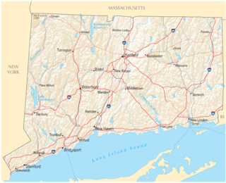
The U.S. state of Connecticut is bordered on the south by Long Island Sound, on the west by New York, on the north by Massachusetts, and on the east by Rhode Island. The state capital and fourth largest city is Hartford, and other major cities and towns include Bridgeport, New Haven, Stamford, Waterbury, Norwalk, Danbury, New Britain, Greenwich, and Bristol. There are 169 incorporated towns in Connecticut, with cities and villages included within some towns.
The Lillinonah Trail is a 5.9-mile (9.5 km) Blue-Blazed hiking trail "system" in the lower Housatonic River valley in Fairfield County and, today, is entirely in Newtown. Most of the trail is in the upper block of Paugussett State Forest.

The Zoar Trail is a 6.5-mile (10.5 km) Blue-Blazed hiking trail "system" in the lower Housatonic River valley in Fairfield County and is entirely in the Sandy Hook section of Newtown in the lower block of Paugussett State Forest.
The Kettletown Trails are a 4.6-mile (7.4 km) Blue-Blazed hiking trail "system" in the lower Housatonic River valley in Fairfield County and are in the towns of Southbury and Oxford -- primarily in the Kettletown State Park and the Jackson Cove recreation area belonging to the town of Oxford.
The Shore Line Electric Railway was a trolley line along the southern coastline of Connecticut, running between New Haven and Old Saybrook with additional branches to Chester and Stony Creek. Unlike most trolley lines in New England, the Shore Line Electric was a true interurban, running large railway-style cars largely on a private right-of-way rather than on public streets. Though its main line was in operation for only 15 nonconsecutive years, the Shore Line Electric briefly acquired a substantial network of trolley lines stretching across eastern Connecticut, including the Norwich and Westerly Railway, the Groton and Stonington Street Railway, and several lines of the Connecticut Company. Most of the trolley line no longer is extant, however, the Shore Line Electric Railway Power House still stands along the mouth of the Connecticut River in Old Saybrook.

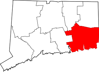
The Gold Coast, also known as Lower Fairfield County or Southwestern Connecticut not limited to the Connecticut panhandle, is an affluent part of Western Connecticut that includes the entire southern portion of Fairfield County as defined by the U.S. Census Bureau, Super-Public Use Microdata Area (Super-PUMA) Region 09600. The area is about 50 miles (80 km) northeast of New York City, and is home to many wealthy Manhattan business executives. Parts of the region are served by the Western Connecticut Council of Governments.
References
- General Statutes of Connecticut (2007), Title 22a, Chapter 444, Section 22a-94.
| | This Connecticut-related article is a stub. You can help Wikipedia by expanding it. |