East Haddam, Connecticut

Last updated

East Haddam, Connecticut
View from the Connecticut River of the Goodspeed Opera House, East Haddam, Connecticut LCCN2012631724.tif
View of the Goodspeed Opera House (left) and Gelston House (right) from the Connecticut River
EastHaddamCTseal.JPG
East Haddam, Connecticut
Coordinates: 41°28′47″N72°23′40″W / 41.47972°N 72.39444°W / 41.47972; -72.39444
CountryUnited States
U.S. state Connecticut
County Middlesex
Region Lower CT River Valley
Incorporated1734
Government
  Type Selectman–town meeting
  First selectmanGeorge Williams (R)
Area
  Total56.6 sq mi (146.6 km2)
  Land54.3 sq mi (140.7 km2)
  Water2.2 sq mi (5.8 km2)
Elevation
[1]
535 ft (163 m)
Population
 (2020)
  Total8,875
  Density163.4/sq mi (63.1/km2)
Demonym East Haddamite
Time zone UTC-5 (Eastern)
  Summer (DST) UTC-4 (Eastern)
ZIP code
06423, 06469
Area code(s) 860/959
FIPS code 09-22280
GNIS feature ID0213422 [1]
Website www.easthaddam.org

East Haddam is a town in Middlesex County, Connecticut, United States. The town is part of the Lower Connecticut River Valley Planning Region. The population was 8,875 at the time of the 2020 census. [2]

Contents

History

Looking north from the Nathan Hale Schoolhouse, 1919 PostcardEastHaddamCTLkgNorthFrNathanHaleSchoolHouse1919.jpg
Looking north from the Nathan Hale Schoolhouse, 1919

Until 1650, the area of East Haddam was inhabited by at least three Indigenous peoples: the Wangunk, the Mohegan and the Niantic. The Indigenous nations called the area "Machimoodus", the place of noises, because of numerous earthquakes that were recorded between 1638 and 1899. Loud rumblings, the "Moodus Noises", could be heard for miles surrounding the epicenter of the quakes near Mt. Tom. The land, which is now Haddam and East Haddam, was purchased by settlers from the natives in 1662 for thirty coats, worth about $100. [3]

Layout of the highways began in 1669 with Creek Row about ¼ mile east of the River and Town Street “The Great Highway” about ¼ mile east of Creek Row. The first permanent settlers established homesteads along Creek Row in 1685. By 1700, there were thirty families living in East Haddam. Agricultural and timber farming, shipbuilding, tanneries and blacksmiths were among the early commerce. Captain John Chapman began ferry service across the Connecticut River in 1695, which ended with the completion of the swing bridge in 1913.

East Haddam was incorporated as a separate town from Haddam in 1734. By 1756, there were nearly 2,000 residents, with the Millington District as the most populated. Growth of commerce brought a surge in population to around 3,000 people by the mid-1800s. In the nineteenth century, Moodus was the “Twine Capital of America,” with twelve mills in operation. [4] In the winter of 1773, American patriot Nathan Hale briefly taught in a one-room schoolhouse in East Haddam which is now a living history museum operated by Connecticut Society of the Sons of the American Revolution [usurped] .

Visitors and residents such as actor William Gillette whose castle home was completed in 1914, were drawn to the area known for its rural charm and natural scenery. The growth of the resort areas of Lake Hayward, Bashan Lake and Moodus Reservoir began in the early 1900s and was a booming business for the next fifty years. Lake Hayward is a small private lake community within East Haddam that is home to around 120 families, most living at the lake only during summer months. [5]

East Haddam was listed as one of the 52 Places to Love in 2021 by the New York Times. [6]

Geography

According to the United States Census Bureau, the town has a total area of 56.6 square miles (147 km2), of which, 54.3 square miles (141 km2) of it is land and 2.2 square miles (5.7 km2) of it (3.96%) is water.

Principal communities

Demographics

Historical population
CensusPop.Note
1790 2,749
1800 2,8052.0%
1810 2,537−9.6%
1820 2,5721.4%
1830 2,6643.6%
1840 2,620−1.7%
1850 2,610−0.4%
1860 3,05617.1%
1870 2,951−3.4%
1880 3,0322.7%
1890 2,599−14.3%
1900 2,485−4.4%
1910 2,422−2.5%
1920 2,312−4.5%
1930 2,114−8.6%
1940 2,2174.9%
1950 2,55415.2%
1960 3,63742.4%
1970 4,67628.6%
1980 5,62120.2%
1990 6,67618.8%
2000 8,33324.8%
2010 9,1269.5%
2020 8,875−2.8%
U.S. Decennial Census [7]

As of the census [8] of 2000, there were 8,333 people, 3,174 households, and 2,285 families residing in the town. The population density was 153.4 inhabitants per square mile (59.2/km2). There were 4,015 housing units at an average density of 73.9 per square mile (28.5/km2). The racial makeup of the town was 97.26% White, 0.84% African American, 0.28% Native American, 0.40% Asian, 0.46% from other races, and 0.77% from two or more races. Hispanic or Latino of any race were 0.98% of the population.

There were 3,174 households, out of which 35.2% had children under the age of 18 living with them, 62.3% were married couples living together, 6.9% had a female householder with no husband present, and 28.0% were non-families. 21.4% of all households were made up of individuals, and 8.1% had someone living alone who was 65 years of age or older. The average household size was 2.58 and the average family size was 3.02.

In the town, the population was spread out, with 25.5% under the age of 18, 4.8% from 18 to 24, 33.3% from 25 to 44, 25.8% from 45 to 64, and 10.6% who were 65 years of age or older. The median age was 38 years. For every 100 females, there were 100.1 males. For every 100 females age 18 and over, there were 96.2 males.

The median income for a household in the town was $62,304, and the median income for a family was $70,091. Males had a median income of $45,500 versus $36,055 for females. The per capita income for the town was $28,112. About 1.0% of families and 2.9% of the population were below the poverty line, including 1.5% of those under age 18 and 1.5% of those age 65 or over. 2017 CERT Town Profile, click here. [9]

Voter Registration and Party Enrollment as of October 25, 2005 [10]
PartyActive VotersInactive VotersTotal VotersPercentage
Democratic 1,529911,62028.72%
Republican 1,181561,23721.93%
Unaffiliated 2,5981792,77749.24%
Minor parties5160.11%
Total5,3133275,640100%
Presidential Election Results [11] [12]
Year Democratic Republican Third Parties
2020 51.2%2,98046.9% 2,7311.9% 114
2016 45.9% 2,33149.0%2,4875.1% 259
2012 53.0%2,47145.2% 2,1091.8% 82
2008 58.9%2,87439.3% 1,9181.8% 87
2004 55.4%2,60742.7% 2,0091.9% 89
2000 52.8%2,18640.7% 1,6876.5% 271
1996 45.4%1,66332.6% 1,19322.0% 804
1992 37.3%1,46826.5% 1,04236.2% 1,427
1988 45.5% 1,45753.1%1,7021.4% 44
1984 36.9% 1,11262.7%1,8850.4% 11
1980 38.9% 1,10446.6%1,32414.5% 413
1976 50.4%1,30849.3% 1,2800.3% 9
1972 41.2% 96857.6%1,3531.2% 28
1968 49.1%1,02844.1%9226.8% 143
1964 67.3%1,24332.7% 6050.00% 0
1960 50.2%93049.8% 9210.00% 0
1956 38.1% 64761.9%1,0490.00% 0

Education

Public

The East Haddam Public School System has about 1,100 students in grades Pre-K–12; about 121 certified teachers, 70 support staff and 7 administrators. Ms. Teresa DeBrito is superintendent of schools. [13] Located in Moodus, Connecticut, the three schools in the public school system are:

Private

Attractions

An auto test track in East Haddam Consumer Reports - product testing - auto test track in East Haddam, Connecticut.tif
An auto test track in East Haddam

Cultural

Historical

Bust of Nathan Hale located in the center of town. Nathan Hale Statue by Enoch Smith Woods, East Haddam, CT - September 2018.jpg
Bust of Nathan Hale located in the center of town.

Natural

Notable Citizens

Filming Location

Related Research Articles

<span class="mw-page-title-main">Middlesex County, Connecticut</span> County in Connecticut, United States

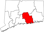
Middlesex County is a county in the south central part of the U.S. state of Connecticut. As of the 2020 census, the population was 164,245. The county was created in May 1785 from portions of Hartford County and New London County.

<span class="mw-page-title-main">Bloomfield, Connecticut</span> Town in Connecticut, United States

Bloomfield is a suburb of Hartford in the Capitol Planning Region, Connecticut, United States. The town's population was 21,535 at the 2020 census. Bloomfield is best known as the headquarters of healthcare services company Cigna.

<span class="mw-page-title-main">Cornwall, Connecticut</span> Town in Connecticut, United States

Cornwall is a town in Litchfield County, Connecticut, United States. The population was 1,567 at the 2020 census. The town is part of the Northwest Hills Planning Region.

<span class="mw-page-title-main">New Hartford, Connecticut</span> Town in Connecticut, United States

New Hartford is a town in Litchfield County, Connecticut, United States. The population was 6,658 at the 2020 census. The town is part of the Northwest Hills Planning Region. The town center is defined by the U.S. Census Bureau as the New Hartford Center census-designated place (CDP). The town is mainly a rural community consisting of farms, homes, and parks. Brodie Park and Ski Sundown are located in New Hartford.

<span class="mw-page-title-main">Chester, Connecticut</span> Town in Connecticut, United States

Chester is a town in Middlesex County, Connecticut, United States. The town is part of the Lower Connecticut River Valley Planning Region. The population was 3,749 at the 2020 census. The town center is defined by the U.S. Census Bureau as a census-designated place (CDP). The name is a transfer from Chester, in England.

<span class="mw-page-title-main">Deep River, Connecticut</span> Town in Connecticut, United States

Deep River is a town in Middlesex County, Connecticut. The town is part of the Lower Connecticut River Valley Planning Region. The population was 4,415 at the 2020 census. The town center is designated by the U.S. Census Bureau as a census-designated place (CDP). Deep River is part of what the locals call the "Tri-town Area", made up of the towns of Deep River, Chester, and Essex.

<span class="mw-page-title-main">Essex, Connecticut</span> Town in Connecticut, United States

Essex is a town in Middlesex County, Connecticut, United States. The town is part of the Lower Connecticut River Valley Planning Region. The population was 6,733 at the 2020 census. It is made up of three villages: Essex Village, Centerbrook, and Ivoryton.

<span class="mw-page-title-main">Haddam, Connecticut</span> Town in Connecticut, United States

Haddam is a town in Middlesex County, Connecticut, United States. The town is part of the Lower Connecticut River Valley Planning Region. The population was 8,452 at the time of the 2020 census. The town was also home to the now-decommissioned Connecticut Yankee Nuclear Power Plant.

<span class="mw-page-title-main">Killingworth, Connecticut</span> Town in Connecticut, United States

Killingworth is a town in Middlesex County, Connecticut, United States. The town is part of the Lower Connecticut River Valley Planning Region. The population was 6,174 at the 2020 United States Census.

<span class="mw-page-title-main">Moodus, Connecticut</span> Census-designated place in Connecticut, United States of America

Moodus is a village in the town of East Haddam, Connecticut, United States. The village is the basis of a census-designated place (CDP) of the same name. The population of the CDP was 1,982 as of the census of 2020.

<span class="mw-page-title-main">Coventry, Connecticut</span> Town in Connecticut, United States

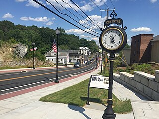
Coventry is a town in Tolland County and in the Capitol Planning Region, Connecticut. The population was 12,235 at the 2020 census. The birthplace of Captain Nathan Hale, Coventry is home to the Nathan Hale Homestead, which is now a museum open to the public. Coventry was incorporated in May 1712.

<span class="mw-page-title-main">Thompson, Connecticut</span> Town in Connecticut, United States

Thompson is a town in Windham County, Connecticut, United States. The town is part of the Northeastern Connecticut Planning Region. The town was named after Sir Robert Thompson, an English landholder. The population was 9,189 at the 2020 census. Thompson is located in the northeastern corner of the state and is bordered on the north by Webster, Massachusetts and Dudley, Massachusetts, on the east by Douglas, Massachusetts and Burrillville, Rhode Island, on the west by Woodstock, Connecticut, and on the south by Putnam, Connecticut.

<span class="mw-page-title-main">Rindge, New Hampshire</span> Town in New Hampshire, United States

Rindge is a town in Cheshire County, New Hampshire, United States. The population was 6,476 at the 2020 census, up from 6,014 at the 2010 census. Rindge is home to Franklin Pierce University, the Cathedral of the Pines and part of Annett State Forest.

<span class="mw-page-title-main">Rockingham, Vermont</span> Town in Vermont, United States

Rockingham is a town along the Connecticut River in Windham County, Vermont, United States. As of the 2020 census, the population was 4,832. Rockingham includes the incorporated villages of Bellows Falls and Saxtons River, as well as a large rural area west of Interstate 91.

<span class="mw-page-title-main">Newport, New Hampshire</span> Place in New Hampshire, United States

Newport is a town in and the county seat of Sullivan County, New Hampshire, United States. It is 43 miles (69 km) west-northwest of Concord, the state capital. The population of Newport was 6,299 at the 2020 census. A covered bridge is in the northwest. The area is noted for maple sugar and apple orchards. Prior to county division in 1827, Newport was in Cheshire County. The central part of town, where 4,735 people resided at the 2020 census, is defined as the Newport census-designated place (CDP) and is located next to the Sugar River at the junction of New Hampshire routes 10 and 11. The town also includes the villages of Kelleyville, Guild, and North Newport.

<span class="mw-page-title-main">Connecticut Route 151</span> State highway in Middlesex County, Connecticut, US

Route 151 is a Connecticut state highway in the Connecticut River valley running from East Haddam via Moodus to the village of Cobalt in East Hampton.

<span class="mw-page-title-main">East Haddam Historic District</span> Historic district in Connecticut, United States

The East Haddam Historic District is a 110-acre (45 ha) historic district in East Haddam, Connecticut representing the historical development of two 18th-century settlements of the town on the east bank of the Connecticut River, Upper Landing and Lower Landing. The district is linear and runs along Route 149. It was listed on the National Register of Historic Places in 1983, and includes a diversity of 18th and 19th-century styles, as well as the town's main civic structures, and the Goodspeed Opera House. Also included in the district are two monuments, one to Nathan Hale and another to Gen. Joseph Spencer, a park, and a cemetery.

<span class="mw-page-title-main">East Hampton, Connecticut</span> Town in Connecticut, United States

East Hampton is a town in Middlesex County, Connecticut, United States. The town is part of the Lower Connecticut River Valley Planning Region. The population was 12,717 at the 2020 census. The town center village is listed as a census-designated place (CDP). East Hampton includes the communities of Cobalt, Middle Haddam, and Lake Pocotopaug.

<span class="mw-page-title-main">Portland, Connecticut</span> Town in Connecticut, United States

Portland is a town in Middlesex County, Connecticut, United States. The town is part of the Lower Connecticut River Valley Planning Region. The population was 9,384 at the 2020 census. The town center is listed as a census-designated place (CDP). It is situated across the Connecticut River from Middletown.

<span class="mw-page-title-main">Nathan Hale Schoolhouse (East Haddam)</span>

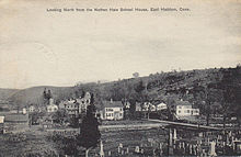
The Nathan Hale Schoolhouse is a historic site in East Haddam, Connecticut. In the winter of 1773, Nathan Hale briefly taught in this one-room schoolhouse before leaving East Haddam for another teaching position in New London, Connecticut. The schoolhouse is owned and operated by the Connecticut Society of the Sons of the American Revolution[usurped].

References

  1. 1 2 U.S. Geological Survey Geographic Names Information System: East Haddam, Connecticut
  2. "Census - Geography Profile: East Haddam town, Middlesex County, Connecticut" . Retrieved December 15, 2021.
  3. "History of East Haddam". easthaddam.org. Archived from the original on February 9, 2011. Retrieved July 2, 2014.
  4. "Historic Buildings of Connecticut » East Haddam". Historicbuildingsct.com. Retrieved March 7, 2017.
  5. "History". Easthaddam.org. Archived from the original on February 9, 2011. Retrieved March 7, 2017.
  6. "52 Places to Love in 2021". The New York Times. January 6, 2021. ISSN   0362-4331 . Retrieved November 17, 2023.
  7. "Census of Population and Housing". Census.gov. Retrieved June 4, 2015.
  8. "U.S. Census website". United States Census Bureau . Retrieved January 31, 2008.
  9. "2017 CERT Town Profile" (PDF). easthaddam.org.
  10. "Registration and Party Enrollment Statistics as of October 25, 2005" (PDF). Connecticut Secretary of State. Archived from the original (PDF) on September 23, 2006. Retrieved October 2, 2006.
  11. "General Election Statements of Vote, 1922 – Current". CT Secretary of State. Retrieved December 24, 2020.
  12. "Election Night Reporting". CT Secretary of State. Retrieved December 24, 2020.
  13. "East Haddam Public Schools". Archived from the original on January 6, 2014. Retrieved January 6, 2014.
  14. "Nathan Hale-Ray High School". Archived from the original on February 24, 2010. Retrieved May 24, 2010.
  15. "Archived copy". Archived from the original on November 19, 2010. Retrieved May 24, 2010.{{cite web}}: CS1 maint: archived copy as title (link)
  16. "East Haddam Public Schools". Archived from the original on March 23, 2010. Retrieved May 24, 2010.
  17. "Welcome to the Official Website of the Town of East Haddam, Connecticut - Music on the River". www.easthaddam.org. Retrieved November 17, 2023.
  18. Story, Contributed (August 29, 2019). "Venture Smith Day honors freed slave, longtime CT resident". The Middletown Press. Archived from the original on August 31, 2019. Retrieved May 16, 2021.
  19. "Allegra Farm And The Horsedrawn Carriage And Sleigh Museum Of New England - All You Need to Know BEFORE You Go (with Photos)". Tripadvisor. Retrieved November 17, 2023.
  20. "Attractions". Easthaddam.org. Retrieved March 7, 2017.
  21. Connecticut, Massachusetts & Rhode Island Tourbook 2007 Edition. (2007) p 42. AAA Publishing, Heathrow, Florida
  22. "First Church of Christ 1794". firstchurcheh.org/about-us/1794-meetinghouse/. August 7, 2014.
  23. "Tracking the Truth of the Underground Railroad - Hartford Courant". Courant.com. September 29, 2002. Retrieved March 7, 2017.
  24. "St. Stephen's Bell". ststeves.org/learn/the-legend-of-our-bell/. August 3, 2019.
  25. "Thunder in the Valley Ancient Drum & Fife Muster". The Company of Fifers & Drummers. Retrieved November 17, 2023.
  26. "Ray of Light Farm - All You Need to Know BEFORE You Go (With Photos)".
  27. 1 2 "Advanced search". IMDb .
  28. "Advanced search". IMDb .