Ledyard Bridge

Last updated
Ledyard Bridge
232 03 Ledyard Bridge.jpg
Coordinates 43°42′13″N72°17′59″W / 43.70361°N 72.29972°W / 43.70361; -72.29972
Carries Vermont Route 10A,
New Hampshire Route 10A,
Appalachian Trail
Crosses Connecticut River
Locale Hanover, New Hampshire and Norwich, Vermont
Maintained by New Hampshire Department of Transportation
Characteristics
Design Beam bridge, originally a covered bridge
History
Construction start1998
Opened1859, 2000
Closed1935 [1]
Location
Ledyard Bridge

The Ledyard Bridge crosses the Connecticut River to connect Hanover, New Hampshire to Norwich, Vermont. It is the third bridge at this crossing to bear the name of the adventurer John Ledyard.

Contents

History

The first "Ledyard Free Bridge" was a covered bridge built in 1859 that was the first bridge across the Connecticut not to charge a toll. (It was the latest of several bridges at this site that went back to the late 18th century.) The bridge was named after Ledyard in 1859 because its eastern abutment was near the site of a tree that Ledyard felled during 1773 in order to make the dugout canoe in which he left Dartmouth College to continue his world travels. [2] [ citation needed ]

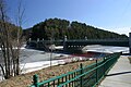
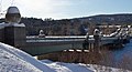
The bridge now standing was built between 1998 and 2000 by the New Hampshire Department of Transportation. [3] At each end it displays a pair of "bridge balls," the controversial Classical ornaments cast in concrete that refer to the gateway to Tuck Drive nearby on the Hanover shore. They are the product of a Concord architect brought in by NHDOT to infuse some extra aesthetic appeal into the design of the bridge.[ citation needed ]

The Ledyard Bridge carries the designation of New Hampshire Route 10A and Vermont Route 10A, a short state highway linking U.S. Route 5 and Interstate 91 on the Vermont side with New Hampshire Route 10 on the New Hampshire side. The Appalachian Trail uses the pedestrian walkway to cross the river.

Border location

Although the border between New Hampshire and Vermont was set at the Vermont shore early in the states' histories, the bridge's monument to that border rests near the middle of the crossing; the reasoning is that the border was fixed before the Wilder Dam pushed the Vermont shore westward during the 1950s.[ citation needed ]

See also

Related Research Articles

<span class="mw-page-title-main">Hanover, New Hampshire</span> Town in the United States

Hanover is a town located along the Connecticut River in Grafton County, New Hampshire, United States. As of the 2020 census, its population was 11,870. The town is home to the Ivy League university Dartmouth College, the U.S. Army Corps of Engineers Cold Regions Research and Engineering Laboratory, and Hanover High School. The Appalachian Trail crosses the town, connecting with a number of trails and nature preserves.

<span class="mw-page-title-main">Interstate 93</span> Interstate Highway in Massachusetts, New Hampshire, and Vermont in the United States

Interstate 93 (I-93) is an Interstate Highway in the New England states of Massachusetts, New Hampshire, and Vermont in the United States. Spanning approximately 190 miles (310 km) along a north–south axis, it is one of three primary Interstate Highways located entirely within New England; the other two are I-89 and I-91. The largest cities along the route are Boston, Massachusetts, and Manchester, New Hampshire; it also travels through the New Hampshire state capital of Concord.

<span class="mw-page-title-main">Interstate 89</span> Interstate in Vermont and New Hampshire

Interstate 89 (I-89) is an Interstate Highway in the New England region of the United States traveling from Bow, New Hampshire, to the Canada–United States border between Highgate Springs, Vermont, and Saint-Armand, Quebec. As with all odd-numbered primary Interstates, I-89 is signed as a north–south highway. However, it follows a primarily northwest-to-southeast path. The route forms a major part of the main connection between the cities of Montreal and Boston. In Quebec, the route continues as Route 133. The eventual completion of Autoroute 35 will lead to a nonstop limited-access highway route between Boston and Montreal, following I-93 south from I-89's terminus. The largest cities directly served by I-89 are Concord, the state capital of New Hampshire; Montpelier, the state capital of Vermont; and Burlington, Vermont. I-89 is one of three main Interstate highways whose route is located entirely within New England, along with I-91 and I-93.

<span class="mw-page-title-main">Connecticut River</span> River in the New England region of the United States

The Connecticut River is the longest river in the New England region of the United States, flowing roughly southward for 406 miles (653 km) through four states. It rises 300 yards south of the U.S. border with Quebec, Canada, and discharges at Long Island Sound. Its watershed encompasses 11,260 square miles (29,200 km2), covering parts of five U.S. states and one Canadian province, via 148 tributaries, 38 of which are major rivers. It produces 70% of Long Island Sound's fresh water, discharging at 18,400 cubic feet (520 m3) per second.

<span class="mw-page-title-main">U.S. Route 3</span> Highway in the United States

U.S. Route 3 (US 3) is a United States Numbered Highway running 277.90 miles (447.24 km) from Cambridge, Massachusetts, through New Hampshire, to the Canada–United States border near Third Connecticut Lake, where it connects to Quebec Route 257.

<span class="mw-page-title-main">New England road marking system</span> Regional Road Network

The New England road marking system was a regional system of marked numbered routes in the six-state region of New England in the United States. The routes were marked by a yellow rectangular sign with black numbers and border. Many signs were painted on telephone poles. The routes were approved by the highway departments of the six New England states in April 1922.

<span class="mw-page-title-main">New Hampshire Route 10</span> North-south state highway in New Hampshire, US

New Hampshire Route 10 is a 122.25-mile-long (196.74 km) north–south state highway in western New Hampshire, United States. Its southern terminus is in Winchester at the Massachusetts state line, where it continues south as Massachusetts Route 10. Administratively, the northern terminus is at a junction with U.S. Route 302 in Haverhill.

<span class="mw-page-title-main">New Hampshire Route 25</span> State highway in New Hampshire, US

New Hampshire Route 25 is a 96.62-mile (155.49 km) long east–west state highway in New Hampshire. It runs completely across the state from Vermont to Maine.

<span class="mw-page-title-main">Route 10A (Vermont–New Hampshire)</span> Highway in Vermont and New Hampshire

Route 10A is a 1.070-mile-long (1.722 km) east-west highway connecting the towns of Norwich, Vermont and Hanover, New Hampshire. The route exists as Vermont Route 10A and New Hampshire Route 10A, with each designation carrying about half of the route's length. The route begins in Norwich at an interchange with Interstate 91 and U.S. Route 5 and runs east, crossing the state line and continuing into downtown Hanover, where it ends at New Hampshire Route 10.

<span class="mw-page-title-main">New Hampshire Route 12</span> State highway in southwestern New Hampshire, US

New Hampshire Route 12 is a 62.773-mile (101.023 km) long north–south state highway in southwestern New Hampshire. Its southern terminus is at the Massachusetts state line in Fitzwilliam, where it continues south as Massachusetts Route 12. Its northern terminus is at the Vermont state line in Claremont, where it continues north as Vermont Route 12. Most of the northern part of NH 12 runs along the Connecticut River.

<span class="mw-page-title-main">New Hampshire Route 119</span> Highway in New Hampshire

New Hampshire Route 119 is a state highway in the U.S. state of New Hampshire. The highway begins in Hinsdale at the Connecticut River, across which the highway continues into Brattleboro, Vermont, as Vermont Route 119 for 0.080 miles (0.129 km) to its terminus at U.S. Route 5 and VT 142. NH 119 heads east 39.908 miles (64.226 km) to the Massachusetts state line in New Ipswich, where the highway continues as Massachusetts Route 119. The state highway is the main east–west highway of southern Cheshire County, where it connects the towns of Hinsdale, Winchester, Richmond, Fitzwilliam, and Rindge.

<span class="mw-page-title-main">Columbia Bridge (Connecticut River)</span> Bridge in New Hampshire and Lemington, Vermont

The Columbia Bridge is a covered bridge, carrying Columbia Bridge Road over the Connecticut River between Columbia, New Hampshire and Lemington, Vermont. Built in 1911–12, it is one of only two New Hampshire bridges built with Howe trusses, and is one of the last covered bridges built in the historic era of covered bridge construction in both states. It was listed on the National Register of Historic Places in 1976.

<span class="mw-page-title-main">Mount Orne Covered Bridge</span> Bridge in New Hampshire to Lunenburg, Vermont

The Mount Orne Bridge is a covered bridge over the Connecticut River between Lancaster, New Hampshire, and Lunenburg, Vermont. It joins Elm Street in South Lancaster with River Road in Lunenburg. Built in 1911, it is one of two Howe truss bridges across the Connecticut River. It was listed on the National Register of Historic Places in 1976.

<span class="mw-page-title-main">Bedell Covered Bridge</span> Bridge in Vermont and Haverhill, New Hampshire

The Bedell Bridge was a Burr truss covered bridge that spanned the Connecticut River between Newbury, Vermont and Haverhill, New Hampshire. Until its most recent destruction in 1979, it was, with a total length of 382 feet (116 m), the second-longest covered bridge in the United States. The bridge was divided into two spans of roughly equal length, and rested on a central pier and shore abutments constructed from mortared rough stone. The eastern abutment has been shored up by the addition of a concrete footing. The bridge was 23 feet (7.0 m) wide, with a roadway width of 18.5 feet (5.6 m). Because the state line is the western low-water mark of the Connecticut River, most of the bridge was in New Hampshire; only the western abutment is in Vermont.

The East–West Highway is a long-proposed east–west highway corridor in northern New England, intended to link remote northern communities in those states with markets in the Maritimes, Quebec, and upstate New York.

<span class="mw-page-title-main">Maine State Route 113</span> State highway in southwestern Maine, US

State Route 113 (SR 113) is a state highway in southwestern Maine. It runs from an intersection with Maine State Route 25 in Standish north to the town of Gilead, where it ends at U.S. Route 2 (US 2) near the New Hampshire border. The northern portion of the route runs along the border, and actually crosses into and out of New Hampshire twice.

<span class="mw-page-title-main">Arch Bridge (Bellows Falls)</span> Bridge in Vermont to North Walpole, New Hampshire

The Bellows Falls Arch Bridge was a three-hinged steel through arch bridge over the Connecticut River between Bellows Falls, Vermont and North Walpole, New Hampshire. It was structurally significant as the longest arch bridge in the United States when it was completed in 1905.

<span class="mw-page-title-main">Piermont Bridge</span> United States historic place

The Piermont Bridge carries New Hampshire Route 25 over the Connecticut River to the contiguous Vermont Route 25 between Piermont, New Hampshire and Bradford, Vermont. It is a Pennsylvania steel through truss bridge, built by the Boston Bridge Works in 1928. The bridge consists of a single span with a clear span of 352' and an overall length of 354'10". The roadbed is 20'7" wide, with a vertical clearance of 14'7". The bridge is approximately 25' above the river. The western (Vermont) abutment is made of split granite quarried from nearby Fairlee Mountain, while the eastern abutment is an early concrete construction built in 1908 by John Storrs for an earlier bridge. The bridge underwent a major renovation in 1993 which included the addition of a sidewalk and replacement of much of the bridge decking.

Transportation in New England encompasses the region's rail and highway networks, seaports, and airports. New England has one of the United States' oldest intercity transportation systems, which remain important to the region's economy. It is also home to the continent's first subway system. The densely populated area has many cities and towns connected by rail and road, and the larger cities each have commercial airports with daily flights to destinations outside of the region.

<span class="mw-page-title-main">Lyme–East Thetford Bridge</span> United States historic place

The Lyme–East Thetford Bridge is a historic bridge over the Connecticut River between Lyme, New Hampshire, and East Thetford, Vermont. From the New Hampshire side it carries East Thetford Road, which becomes Vermont Route 113 as it enters Vermont. A Parker truss bridge completed in 1937, it is 471 feet (144 m) long. The bridge was added to the National Register of Historic Places in 2020.

References

  1. "BRIDGES OF THE PAST - New Hampshire Covered Bridges". www.nh.gov.
  2. Hard, Walter (1998) [1947]. Conuel, Thomas (series); Allen, Hervey; Carmer, Carl; Crawford, Jean (associate); Ball, Faith (art) (eds.). The Connecticut. The Rivers of America (2nd ed.). Lincoln, Massachusetts: Massachusetts Audubon Society. p. 154. ISBN   0-932691-27-7.
  3. Associated Press (December 31, 1994), "N.H., Vermont end dispute over design of proposed bridge", The Boston Globe (Boston, MA)