Plainfield, New Hampshire

Last updated

Plainfield, New Hampshire
Meriden Hill, Looking East, Meriden, NH.jpg
Meriden Hill c. 1908
Plainfield, NH Town Seal.png
Sullivan County New Hampshire incorporated and unincorporated areas Plainfield highlighted.svg
Location in Sullivan County and the state of New Hampshire.
Coordinates: 43°32′03″N72°21′22″W / 43.53417°N 72.35611°W / 43.53417; -72.35611
Country United States
State New Hampshire
County Sullivan
Incorporated 1761
Villages
Government
   Select Board Eric R. Brann
Ron C. Eberhardt
Amy S. Lappin
   Town Administrator Stephen Halleran
Area
[1]
  Total53.0 sq mi (137.2 km2)
  Land52.2 sq mi (135.3 km2)
  Water0.7 sq mi (1.9 km2)  1.40%
Elevation
522 ft (159 m)
Population
 (2020)
  Total2,459
  Density47/sq mi (18.2/km2)
Time zone UTC-5 (Eastern)
  Summer (DST) UTC-4 (Eastern)
ZIP Codes
Area code 603
FIPS code 33-62340
GNIS feature ID 0873700
Website www.plainfieldnh.org

Plainfield is a town in Sullivan County, New Hampshire, United States. At the time of the 2020 census, the town had a population of 2,459. [2] The town is home to the Helen Woodruff Smith Bird Sanctuary and Annie Duncan State Forest.

Contents

The village of Plainfield, where 178 people resided at the 2020 census, [3] is defined as the Plainfield census-designated place (CDP) and is located in the western part of the town along New Hampshire Route 12A. Plainfield also includes the village of Meriden, home to Kimball Union Academy, a private preparatory school.

History

The town was first settled by a group from Plainfield, Connecticut. It was one of the towns incorporated by colonial governor Benning Wentworth in 1761, at the beginning of the reign of King George III. A part of Plainfield known as "Meriden Parish", named for the farm of Massachusetts Governor Jonathan Belcher, became the site of Kimball Union Academy, built in 1813. [4]

Plainfield lies on the northern edge of the enclave known as the Cornish Art Colony, which existed between 1885 and 1930. Maxfield Parrish painted the stage backdrop in the Plainfield Town Hall. [5] Parrish purchased land close to his parents' estate in 1898, at the age of 28, and relocated after leaving Philadelphia. He designed and built his home, The Oaks, over several years, eventually also designing and building an elaborate studio some distance behind the house. Parrish lived in Plainfield for 67 years, with the exception of a several-month period in Arizona, and a nine-month period when he resided and worked in New York City.[ citation needed ] In 1910, Ernest Harold Baynes founded the Meriden Bird Club, the first institution of its type in the nation.

Geography

According to the United States Census Bureau, the town has a total area of 53.0 square miles (137.2 km2), of which 52.2 square miles (135.3 km2) are land and 0.73 square miles (1.9 km2) are water, comprising 1.40% of the town. Bounded on the west by the Connecticut River, Plainfield is drained by Blood's Brook and Blow-me-down Brook. Great Brook, a tributary of the Mascoma River, drains the northeast corner of the town. Croydon Mountain is a high ridge that occupies the eastern edge of the town. Grantham Mountain, a peak along the ridge, is the highest point in Plainfield at 2,660 feet (810 m) above sea level.

The town is crossed by the north-south state routes 12A and 120. Route 12A, serving the western part of the town, passes through the village of Plainfield and leads north to West Lebanon and south to the west part of Claremont. Route 120, passing through Meriden in the eastern part of the town, leads north to downtown Lebanon and south to downtown Claremont.

Adjacent municipalities

Demographics

Historical population
CensusPop.Note
1790 1,024
1800 1,43540.1%
1810 1,4632.0%
1820 1,460−0.2%
1830 1,5818.3%
1840 1,552−1.8%
1850 1,392−10.3%
1860 1,62016.4%
1870 1,589−1.9%
1880 1,372−13.7%
1890 1,173−14.5%
1900 1,114−5.0%
1910 987−11.4%
1920 853−13.6%
1930 8580.6%
1940 97013.1%
1950 1,0114.2%
1960 1,0715.9%
1970 1,32323.5%
1980 1,74932.2%
1990 2,05617.6%
2000 2,2419.0%
2010 2,3645.5%
2020 2,4594.0%
U.S. Decennial Census [6]

As of the census of 2010, there were 2,364 people, 923 households, and 684 families residing in the town. There were 984 housing units, of which 61, or 6.2%, were vacant. The racial makeup of the town was 98.0% white, 0.5% African American, 0.1% Native American, 0.5% Asian, 0.0% Native Hawaiian or Pacific Islander, 0.04% some other race, and 0.9% from two or more races. 1.1% of the population were Hispanic or Latino of any race. [7]

Of the 923 households, 32.3% had children under the age of 18 living with them, 63.5% were headed by married couples living together, 7.0% had a female householder with no husband present, and 25.9% were non-families. 19.5% of all households were made up of individuals, and 6.4% were someone living alone who was 65 years of age or older. The average household size was 2.51, and the average family size was 2.88. [7]

In the town, 22.8% of the population were under the age of 18, 4.4% were from 18 to 24, 22.4% from 25 to 44, 37.1% from 45 to 64, and 13.3% were 65 years of age or older. The median age was 45.2 years. For every 100 females, there were 100.0 males. For every 100 females age 18 and over, there were 97.5 males. [7]

For the period 2011–2015, the estimated median annual income for a household was $82,250, and the median income for a family was $90,729. Male full-time workers had a median income of $56,385 versus $52,813 for females. The per capita income for the town was $38,810. 1.0% of the population and 0.3% of families were below the poverty line. 0.0% of the population under the age of 18 and 2.5% of those 65 or older were living in poverty. [8]

Notable people

Related Research Articles

<span class="mw-page-title-main">Sullivan County, New Hampshire</span> County in New Hampshire, United States

Sullivan County is a county in the U.S. state of New Hampshire. As of the 2020 census, the population was 43,063, making it the second-least populous county in New Hampshire. Its county seat is Newport.

<span class="mw-page-title-main">Cornish, Maine</span> Town in the state of Maine, United States

Cornish is a town in York County, Maine, United States. The population was 1,508 at the 2020 census. It is part of the Portland–South Portland–Biddeford, Maine metropolitan statistical area. The main village in town is the Cornish census-designated place. The village has a number of antique shops and restaurants near historic Thompson Park. Cornish is home to the first concrete bridge in North America.

<span class="mw-page-title-main">Lebanon, Maine</span> Town in Maine, United States

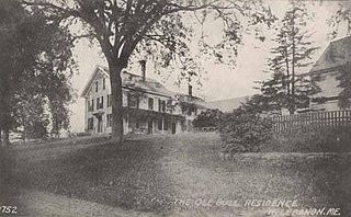
Lebanon is a town in York County, Maine, United States. The population was 6,469 at the 2020 census. Lebanon includes the villages of Center Lebanon, West Lebanon, North Lebanon, South Lebanon, and East Lebanon. It is the westernmost town in Maine. Lebanon is part of the Portland–South Portland–Biddeford, Maine metropolitan statistical area.

<span class="mw-page-title-main">Gilford, New Hampshire</span> Town in New Hampshire, United States

Gilford is a town in Belknap County, New Hampshire, United States. The population was 7,699 at the 2020 census, up from 7,126 at the 2010 census. Situated on Lake Winnipesaukee, Gilford is home to Governors Island, Ellacoya State Beach, Belknap Mountain State Forest, Gunstock Mountain Resort, and the Bank of New Hampshire Pavilion, a seasonal outdoor concert venue. The lakeside village of Glendale lies within Gilford's borders.

<span class="mw-page-title-main">Gilsum, New Hampshire</span> Town in New Hampshire, United States

Gilsum is a town in Cheshire County, New Hampshire, United States. The population was 752 at the 2020 census. Home to Bear's Den Natural Area, Gilsum includes Gilsum Lower Village.

<span class="mw-page-title-main">Marlow, New Hampshire</span> Town in New Hampshire, United States

Marlow is a town in Cheshire County, New Hampshire, United States. The population was 749 at the 2020 census. Marlow is home to Honey Brook State Forest.

<span class="mw-page-title-main">Sullivan, New Hampshire</span> Town in New Hampshire, United States

Sullivan is a town in Cheshire County, New Hampshire, United States. The population was 658 at the 2020 census. It includes the villages of East Sullivan and Ellisville.

<span class="mw-page-title-main">Troy, New Hampshire</span> Town in New Hampshire, United States

Troy is a town in Cheshire County, New Hampshire, United States. The population was 2,130 at the 2020 census. It is situated west of Mount Monadnock.

<span class="mw-page-title-main">Groton, New Hampshire</span> Town in New Hampshire, United States

Groton is a town in Grafton County, New Hampshire, United States. The population was 569 at the 2020 census.

<span class="mw-page-title-main">Lebanon, New Hampshire</span> City in New Hampshire, United States

Lebanon is the only city in Grafton County, New Hampshire, United States. The population was 14,282 at the 2020 census, up from 13,151 at the 2010 census. Lebanon is in western New Hampshire, south of Hanover, near the Connecticut River. It is the home to Dartmouth–Hitchcock Medical Center and Dartmouth College's Geisel School of Medicine, together comprising the largest medical facility between Boston, Massachusetts, and Burlington, Vermont.

<span class="mw-page-title-main">Acworth, New Hampshire</span> Town in New Hampshire, United States

Acworth is a town in Sullivan County, New Hampshire, United States. At the 2020 census, the town had a total population of 853.

<span class="mw-page-title-main">Claremont, New Hampshire</span> City in New Hampshire, United States

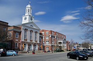
Claremont is the only city in Sullivan County, New Hampshire, United States. The population was 12,949 at the 2020 census.

<span class="mw-page-title-main">Cornish, New Hampshire</span> Town in New Hampshire, United States

Cornish is a town in Sullivan County, New Hampshire, United States. The population was 1,616 at the 2020 census. Cornish has four covered bridges. Each August, it is home to the Cornish Fair.

<span class="mw-page-title-main">Grantham, New Hampshire</span> Town in New Hampshire, United States

Grantham is a town in Sullivan County, New Hampshire, United States. The population was 3,404 at the 2020 census, an increase over the figure of 2,985 tabulated in 2010. The planned community of Eastman is in the eastern part of the town.

<span class="mw-page-title-main">Langdon, New Hampshire</span> Place in New Hampshire, United States

Langdon is a town in Sullivan County, New Hampshire, United States. The population was 651 at the 2020 census.

<span class="mw-page-title-main">Randolph, Vermont</span> Town in Vermont, United States

Randolph is a town in Orange County, Vermont, United States. The population was 4,774 at the 2020 census, making Randolph the largest town in Orange County. The town is a commercial center for many of the smaller, rural farming communities that surround it.

<span class="mw-page-title-main">Marlborough, New Hampshire</span> Town in New Hampshire, United States

Marlborough is a town in Cheshire County, New Hampshire, United States. The population was 2,096 at the 2020 census. The town is home to the Kensan-Devan Wildlife Sanctuary at Meetinghouse Pond.

<span class="mw-page-title-main">Charlestown, New Hampshire</span> Place in New Hampshire, United States

Charlestown is a town in Sullivan County, New Hampshire, United States. The population was 4,806 at the 2020 census, down from 5,114 at the 2010 census. The town is home to Hubbard State Forest and the headquarters of the Student Conservation Association.

Plainfield is a census-designated place (CDP) and the namesake village in the town of Plainfield, Sullivan County, New Hampshire, United States. The population of the CDP was 178 at the 2020 census, out of 2,459 in the entire town.

<span class="mw-page-title-main">Plainfield Town Hall</span> United States historic place

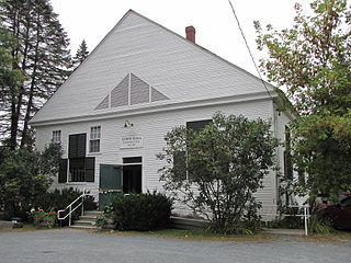
Plainfield Town Hall is one of two town halls in Plainfield, New Hampshire. This town hall stands on New Hampshire Route 12A, north of its junction with Daniels Road. Built in 1846 using timber from an earlier town hall, it is a good example of vernacular Greek Revival architecture. It is further notable for the artwork on its stage backdrop, executed by Maxfield Parrish. The building was listed on the National Register of Historic Places in 1985.

References

  1. "2021 U.S. Gazetteer Files – New Hampshire". United States Census Bureau. Retrieved January 10, 2022.
  2. "Census - Geography Profile: Plainfield town, Sullivan County, New Hampshire" . Retrieved December 24, 2021.
  3. "Census - Geography Profile: Plainfield CDP, New Hampshire" . Retrieved December 24, 2021.
  4. Coolidge, Austin J.; John B. Mansfield (1859). A History and Description of New England. Boston, Massachusetts: A.J. Coolidge. pp.  618–619. coolidge mansfield history description new england 1859.
  5. Cornish Arts Colony in Cornish and Plainfield, New Hampshire 1885–1930
  6. "Census of Population and Housing". Census.gov. Retrieved June 4, 2016.
  7. 1 2 3 "Profile of General Population and Housing Characteristics: 2010 Census Summary File 1 (DP-1): Plainfield town, Sullivan County, New Hampshire". American Factfinder. U.S. Census Bureau. Archived from the original on February 14, 2020. Retrieved November 13, 2017.
  8. "Selected Economic Characteristics: 2011–2015 American Community Survey 5-Year Estimates (DP03): Plainfield town, Sullivan County, New Hampshire". American Factfinder. U.S. Census Bureau. Archived from the original on February 13, 2020. Retrieved November 13, 2017.
  9. "AWAY FOR THE WEEKEND". NY Daily News. Retrieved February 28, 2016.
  10. Teltsch, Kathleen (June 14, 1994). "5 New Yorkers Among MacArthur Recipients". New York Times. Retrieved April 9, 2017.