Sullivan County, New Hampshire

Last updated

Sullivan County
LempsterNHWindFarm Cemetery.jpg
Sullivan County nh seal.jpg
Map of New Hampshire highlighting Sullivan County.svg
Location within the U.S. state of New Hampshire
New Hampshire in United States.svg
New Hampshire's location within the U.S.
Coordinates: 43°20′39″N72°14′50″W / 43.344208°N 72.24733°W / 43.344208; -72.24733
CountryFlag of the United States.svg United States
StateFlag of New Hampshire.svg  New Hampshire
Founded1827
Named for John Sullivan
Seat Newport
Largest city Claremont
Area
  Total552.1 sq mi (1,430 km2)
  Land537.5 sq mi (1,392 km2)
  Water14.6 sq mi (38 km2)  2.6%
Population
 (2020)
  Total43,063
  Density80.1/sq mi (30.9/km2)
Time zone UTC−5 (Eastern)
  Summer (DST) UTC−4 (EDT)
Congressional district 2nd
Website www.sullivancountynh.gov

Sullivan County is a county in the U.S. state of New Hampshire. As of the 2020 census, the population was 43,063, [1] making it the second-least populous county in New Hampshire. Its county seat is Newport. [2]

Contents

Sullivan County is included in the Claremont-Lebanon, NH-VT Micropolitan Statistical Area.

History

Sullivan County was organized at Newport in 1827 from the northern portion of Cheshire County. It is named for John Sullivan (1740–1795), the Revolutionary War hero and a former governor.

Geography

According to the U.S. Census Bureau, the county has a total area of 552 square miles (1,430 km2), of which 537 square miles (1,390 km2) is land and 15 square miles (39 km2) (2.7%) is water. [3] It is the third-smallest county in New Hampshire by area.

Adjacent counties

National protected area

Demographics

Historical population
CensusPop.Note
1830 19,669
1840 20,3403.4%
1850 19,375−4.7%
1860 19,041−1.7%
1870 18,058−5.2%
1880 18,1610.6%
1890 17,304−4.7%
1900 18,0094.1%
1910 19,3377.4%
1920 20,9228.2%
1930 24,28616.1%
1940 25,4424.8%
1950 26,4413.9%
1960 28,0676.1%
1970 30,94910.3%
1980 36,06316.5%
1990 38,5927.0%
2000 40,4584.8%
2010 43,7428.1%
2020 43,063−1.6%
U.S. Decennial Census [4]
1790-1960 [5] 1900-1990 [6]
1990-2000 [7] 2010-2018 [8]

2000 census

At the 2000 census, [9] there were 40,458 people, 16,530 households and 11,174 families living in the county. The population density was 29/; (75/sq mi). There were 20,158 housing units at an average density of 38 units per square mile (15/km2). The racial makeup of the county was 97.99% White, 0.24% Black or African American, 0.29% Native American, 0.37% Asian, 0.02% Pacific Islander, 0.14% from other races, and 0.94% from two or more races. 0.55% of the population were Hispanic or Latino of any race. 16.9% were of English, 14.7% French, 11.7% French Canadian, 10.7% American, 10.0% Irish, 6.2% German and 5.1% Italian ancestry. 96.1% spoke English and 1.6% French as their first language.

There were 16,530 households, of which 29.40% had children under the age of 18 living with them, 54.70% were married couples living together, 8.60% had a female householder with no husband present, and 32.40% were non-families. 25.70% of all households were made up of individuals, and 10.90% had someone living alone who was 65 years of age or older. The average household size was 2.41 and the average family size was 2.88.

23.90% of the population were under the age of 18, 6.40% from 18 to 24, 28.00% from 25 to 44, 25.90% from 45 to 64, and 15.80% who were 65 years of age or older. The median age was 40 years. For every 100 females there were 97.10 males. For every 100 females age 18 and over, there were 93.50 males.

The median household income was $40,938 and the median family income was $48,516. Males had a median income of $32,185 versus $24,615 for females. The per capita income for the county was $21,319. About 5.20% of families and 8.50% of the population were below the poverty line, including 9.50% of those under age 18 and 8.80% of those age 65 or over.

2010 census

As of the 2010 United States census, there were 43,742 people, 18,126 households, and 12,025 families living in the county. [10] The population density was 81.4 inhabitants per square mile (31.4/km2). There were 22,341 housing units at an average density of 41.6 per square mile (16.1/km2). [11] The racial makeup of the county was 97.0% white, 0.6% Asian, 0.4% black or African American, 0.3% American Indian, 0.3% from other races, and 1.4% from two or more races. Those of Hispanic or Latino origin made up 1.1% of the population. [10] In terms of ancestry, 23.9% were English, 16.3% were Irish, 9.2% were German, 7.1% were Italian, 6.0% were French Canadian, 5.2% were Scottish, 5.1% were Polish, and 4.4% were American. [12]

Of the 18,126 households, 28.5% had children under the age of 18 living with them, 51.3% were married couples living together, 9.9% had a female householder with no husband present, 33.7% were non-families, and 26.1% of all households were made up of individuals. The average household size was 2.37 and the average family size was 2.82. The median age was 43.9 years. [10]

The median income for a household in the county was $50,689 and the median income for a family was $61,959. Males had a median income of $44,408 versus $34,233 for females. The per capita income for the county was $26,322. About 7.5% of families and 10.0% of the population were below the poverty line, including 12.6% of those under age 18 and 7.9% of those age 65 or over. [13]

Politics and government

United States presidential election results for Sullivan County, New Hampshire [14]
Year Republican Democratic Third party
No.%No.%No.%
2020 11,50847.08%12,39050.69%5462.23%
2016 10,79647.60%10,21045.01%1,6777.39%
2012 9,26942.45%12,16655.71%4021.84%
2008 9,16940.30%13,24958.23%3361.48%
2004 10,14246.51%11,43452.44%2281.05%
2000 9,30449.84%8,22444.05%1,1406.11%
1996 6,82439.54%8,38048.55%2,05611.91%
1992 6,31835.50%7,92144.50%3,56020.00%
1988 8,83657.82%6,37841.73%690.45%
1984 9,22064.75%4,96234.85%570.40%
1980 7,47252.85%4,88934.58%1,77612.56%
1976 6,67950.57%6,32347.88%2051.55%
1972 7,90158.13%5,55440.86%1371.01%
1968 6,09449.43%5,81747.19%4173.38%
1964 3,97531.15%8,78768.85%00.00%
1960 7,10552.34%6,46947.66%00.00%
1956 8,40366.44%4,23933.52%50.04%
1952 8,31763.68%4,74336.32%00.00%
1948 6,00355.49%4,69643.41%1191.10%
1944 5,93549.82%5,97250.13%60.05%
1940 5,58348.74%5,87251.26%00.00%
1936 5,34750.74%5,11348.52%780.74%
1932 5,15353.79%4,36845.60%580.61%
1928 5,75461.57%3,54937.97%430.46%
1924 5,18768.03%2,26829.74%1702.23%
1920 4,64764.35%2,52134.91%540.75%
1916 2,19349.33%2,21549.82%380.85%
1912 1,67738.85%1,52335.28%1,11725.87%
1908 2,75863.21%1,46933.67%1363.12%
1904 2,77464.21%1,44733.50%992.29%
1900 2,55961.43%1,53836.92%691.66%
1896 2,75071.45%86522.47%2346.08%
1892 2,43453.84%2,02144.70%661.46%
1888 2,58854.95%2,04043.31%821.74%
1884 2,47753.95%2,03144.24%831.81%
1880 2,72955.46%2,17544.20%170.35%
1876 2,56854.91%2,10645.03%30.06%

County Commission

The executive power of Sullivan County's government is held by three county commissioners, each representing one of the three commissioner districts within the county.

DistrictCommissionerHometownParty
1Joe Osgood Claremont Republican
2Ben Nelson Grantham Republican
3George Hebert Goshen Republican

[15]

In addition to the County Commission, there are five directly elected officials: they include County Attorney, Register of Deeds, County Sheriff, Register of Probate, and County Treasurer. [16]

OfficeName
County AttorneyMarc Hathaway (R)
Register of DeedsJanet Gibson (R)
County SheriffJohn Simonds (R)
Register of ProbateRodd Ward (R)
County TreasurerMichael Sanderson (R)

General court

The general court delegation from Sullivan County is made up of all of the members of the New Hampshire House of Representatives from the county. In total there are 13 members from 11 different districts. The party distribution of representatives after the 2022 elections is as follows. [17]

AffiliationMembersVoting share
Democratic Party 646.2%
Republican Party 753.8%
Total13100%

Communities

City

Towns

Census-designated places

Other populated places

Geographical features

Lakes

Mountains

County services

The Sullivan County Department of Corrections operates the county prison in the town of Unity.

See also

Related Research Articles

<span class="mw-page-title-main">Ashland County, Ohio</span> County in Ohio, United States

Ashland County is a county located in the northeastern portion of the U.S. state of Ohio. As of the 2020 census, the population was 52,447. Its county seat and largest city is Ashland. The county is named for "Ashland", the home of Senator Henry Clay near Lexington, Kentucky. It was formed in 1846 from parts of Huron, Lorain, Richland and Wayne Counties.

<span class="mw-page-title-main">Cheshire County, New Hampshire</span> County in New Hampshire, United States

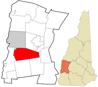
Cheshire County is a county in the southwestern corner of the U.S. state of New Hampshire. As of the 2020 census, the population was 76,458. Its county seat is the city of Keene. Cheshire was one of the five original counties of New Hampshire, and is named for the county of Cheshire in England. It was organized in 1771 at Keene. Sullivan County was created from the northern portion of Cheshire County in 1827.

<span class="mw-page-title-main">Marlow, New Hampshire</span> Town in New Hampshire, United States

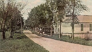
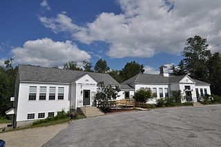
Marlow is a town in Cheshire County, New Hampshire, United States. The population was 749 at the 2020 census. Marlow is home to Honey Brook State Forest.

<span class="mw-page-title-main">Stoddard, New Hampshire</span> Town in New Hampshire, United States

Stoddard is a town in Cheshire County, New Hampshire, United States. The population was 1,374 at the 2020 census, up from 1,232 at the 2010 census.

<span class="mw-page-title-main">Sullivan, New Hampshire</span> Town in New Hampshire, United States

Sullivan is a town in Cheshire County, New Hampshire, United States. The population was 658 at the 2020 census. It includes the villages of East Sullivan and Ellisville.

<span class="mw-page-title-main">Surry, New Hampshire</span> Town in New Hampshire, United States

Surry is a town in Cheshire County, New Hampshire, United States. The population was 820 at the 2020 census, up from 732 at the 2010 census.

<span class="mw-page-title-main">Danbury, New Hampshire</span> Town in New Hampshire, United States

Danbury is a town in Merrimack County, New Hampshire, United States. The population was 1,250 at the 2020 census.

<span class="mw-page-title-main">New London, New Hampshire</span> Town in New Hampshire, United States

New London is a town in Merrimack County, New Hampshire, United States. The population was 4,400 at the 2020 census. The town is the home of Colby–Sawyer College, site of the Gordon Research Conferences since 1947.

<span class="mw-page-title-main">Newbury, New Hampshire</span> Town in New Hampshire, United States

Newbury is a town in Merrimack County, New Hampshire, United States. The population was 2,172 at the 2020 census.

<span class="mw-page-title-main">Wilmot, New Hampshire</span> Town in New Hampshire, United States

Wilmot is a town in Merrimack County, New Hampshire, United States. The population was 1,407 at the 2020 census. The town includes the communities of Wilmot, Wilmot Flat, and North Wilmot.

<span class="mw-page-title-main">Acworth, New Hampshire</span> Town in New Hampshire, United States

Acworth is a town in Sullivan County, New Hampshire, United States. At the 2020 census, the town had a total population of 853.

<span class="mw-page-title-main">Croydon, New Hampshire</span> Place in New Hampshire, United States

Croydon is a town in Sullivan County, New Hampshire, United States. The population was 801 at the 2020 census.

<span class="mw-page-title-main">Goshen, New Hampshire</span> Place in New Hampshire, United States

Goshen is a town in Sullivan County, New Hampshire, United States. The population was 796 at the 2020 census.

<span class="mw-page-title-main">Langdon, New Hampshire</span> Place in New Hampshire, United States

Langdon is a town in Sullivan County, New Hampshire, United States. The population was 651 at the 2020 census.

<span class="mw-page-title-main">Lempster, New Hampshire</span> Place in New Hampshire, United States

Lempster is a town in Sullivan County, New Hampshire, United States. The population was 1,118 at the 2020 census. Settlements include the town center and the village of East Lempster.

<span class="mw-page-title-main">Springfield, New Hampshire</span> Place in New Hampshire, United States

Springfield is a town in Sullivan County, New Hampshire, United States. The population was 1,259 at the 2020 census. Gile State Forest is located within the town.

<span class="mw-page-title-main">Sunapee, New Hampshire</span> Place in New Hampshire, United States

Sunapee is a town in Sullivan County, New Hampshire, United States. The population was 3,342 at the 2020 census. The town is home to part of Lake Sunapee and includes the village of Georges Mills.

<span class="mw-page-title-main">Unity, New Hampshire</span> Place in New Hampshire, United States

Unity is a town in Sullivan County, New Hampshire, United States. The population was 1,518 at the 2020 census, down from 1,671 at the 2010 census. The town includes the villages of Unity, East Unity, Quaker City, and West Unity.

<span class="mw-page-title-main">Newport (CDP), New Hampshire</span> Census-designated place in New Hampshire, United States

Newport is a census-designated place (CDP) comprising the main village and surrounding rural land in the town of Newport, Sullivan County, New Hampshire, United States. The population of the CDP was 4,735 at the 2020 census, out of 6,299 in the entire town.

<span class="mw-page-title-main">Newport, New Hampshire</span> Place in New Hampshire, United States

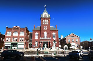
Newport is a town in and the county seat of Sullivan County, New Hampshire, United States. It is 43 miles (69 km) west-northwest of Concord, the state capital. The population of Newport was 6,299 at the 2020 census. A covered bridge is in the northwest. The area is noted for maple sugar and apple orchards. Prior to county division in 1827, Newport was in Cheshire County. The central part of town, where 4,735 people resided at the 2020 census, is defined as the Newport census-designated place (CDP) and is located next to the Sugar River at the junction of New Hampshire routes 10 and 11. The town also includes the villages of Kelleyville, Guild, and North Newport.

References

  1. "Census - Geography Profile: Sullivan County, New Hampshire". United States Census Bureau . Retrieved November 21, 2021.
  2. "Find a County". National Association of Counties. Retrieved June 7, 2011.
  3. "2010 Census Gazetteer Files". United States Census Bureau. August 22, 2012. Archived from the original on December 27, 2014. Retrieved December 27, 2014.
  4. "U.S. Decennial Census". United States Census Bureau. Retrieved December 27, 2014.
  5. "Historical Census Browser". University of Virginia Library. Retrieved December 27, 2014.
  6. "Population of Counties by Decennial Census: 1900 to 1990". United States Census Bureau. Retrieved December 27, 2014.
  7. "Census 2000 PHC-T-4. Ranking Tables for Counties: 1990 and 2000" (PDF). United States Census Bureau. Archived (PDF) from the original on March 27, 2010. Retrieved December 27, 2014.
  8. "State & County QuickFacts". United States Census Bureau. Archived from the original on August 1, 2011. Retrieved September 24, 2013.
  9. "U.S. Census website". United States Census Bureau . Retrieved January 31, 2008.
  10. 1 2 3 "DP-1 Profile of General Population and Housing Characteristics: 2010 Demographic Profile Data". United States Census Bureau. Archived from the original on February 13, 2020. Retrieved January 12, 2016.
  11. "Population, Housing Units, Area, and Density: 2010 - County". United States Census Bureau. Archived from the original on February 13, 2020. Retrieved January 12, 2016.
  12. "DP02 SELECTED SOCIAL CHARACTERISTICS IN THE UNITED STATES – 2006-2010 American Community Survey 5-Year Estimates". United States Census Bureau. Archived from the original on February 13, 2020. Retrieved January 12, 2016.
  13. "DP03 SELECTED ECONOMIC CHARACTERISTICS – 2006-2010 American Community Survey 5-Year Estimates". United States Census Bureau. Archived from the original on February 13, 2020. Retrieved January 12, 2016.
  14. Leip, David. "Dave Leip's Atlas of U.S. Presidential Elections". uselectionatlas.org. Retrieved June 9, 2018.
  15. "General Election Winners - 11/03/2020" (PDF). New Hampshire Secretary of State's Office. November 11, 2020. Retrieved December 8, 2020.
  16. "Sullivan County Elected Officials". Archived from the original on June 28, 2018. Retrieved August 7, 2018.
  17. "General Election Winners - 11/03/2020" (PDF). New Hampshire Secretary of State's Office. November 11, 2020. Retrieved December 8, 2020.

43°22′N72°13′W / 43.36°N 72.22°W / 43.36; -72.22