Winchester, New Hampshire

Last updated

Winchester, New Hampshire
Town
WinchesterNH ConantLibrary.jpg
Winchester, NH Town Seal.png
Cheshire-Winchester-NH.png
Coordinates: 42°46′24″N72°22′59″W / 42.77333°N 72.38306°W / 42.77333; -72.38306
Country United States
State New Hampshire
County Cheshire
Incorporated 1753
Villages
Government
   Board of Selectmen
  • Jack Marsh, Jr.
  • Theresa Sepe
  • Herbert C. Stephens
  • Natalie Quevedo
  • Ben Kilanski
  Town AdministratorKarey Miner
Area
[1]
  Total55.6 sq mi (143.9 km2)
  Land55.0 sq mi (142.4 km2)
  Water0.6 sq mi (1.5 km2)  1.01%
Elevation
433 ft (132 m)
Population
 (2020) [2]
  Total4,150
  Density75/sq mi (29.1/km2)
Time zone UTC-5 (Eastern)
  Summer (DST) UTC-4 (Eastern)
ZIP codes
03470 (Winchester)
03441 (Ashuelot)
Area code 603
FIPS code 33-85540
GNIS feature ID0873757
Website www.winchester-nh.gov

Winchester is a town in Cheshire County, New Hampshire, United States. The population was 4,150 at the 2020 census. [2] The primary community in the town, where 1,606 people resided at the 2020 census, is defined by the U.S. Census Bureau as the Winchester census-designated place (CDP). The town also includes the village of Ashuelot and part of Pisgah State Park.

Contents

History

Postcard of town, 1909 Post Office, Winchester, NH.jpg
Postcard of town, 1909

Originally named "Arlington" in honor of Charles Fitzroy, Earl of Arlington, this town was one of those established in 1733 by colonial Governor Jonathan Belcher as protection for the Massachusetts Bay Colony border at the Connecticut River. This was in the area encompassed in the relatively newly acquired Equivalent Lands. [3] After being designated a part of the Province of New Hampshire in 1741, the town was granted to Colonel Josiah Willard, commander of the Fort Dummer outpost. In 1753, it was incorporated by Governor Benning Wentworth as "Winchester", for Charles Paulet, 3rd Duke of Bolton, 8th Marquess of Winchester, and constable of the Tower of London. [4]

Pioneers who came to the town as early as 1732 were attacked many times by Indians. Several settlers were taken captive, and the town was burned in 1745. [4] Its church, founded in 1736, is the oldest religious body in Cheshire County. The town has two covered bridges.

The Winchester Profession, an influential statement of the principles of Universalism, was adopted at a Universalist congress in Winchester in 1803. [5]

Although it has been an agricultural town, many small industries have been established in Winchester. In the 1830s, Graves & Company was among the nation's first manufacturers of musical instruments. The coming of the Ashuelot Railroad in 1850 fostered the growth of textile mills and wooden-ware factories, especially box manufacture and leather tanning. [6]

Geography

According to the United States Census Bureau, the town has a total area of 55.6 square miles (143.9 km2), of which 55.0 square miles (142.4 km2) are land and 0.6 square miles (1.5 km2) are water, comprising 1.01% of the town. [1] Winchester is drained by the Ashuelot River and its tributary Mirey Brook. Pisgah Reservoir and Kilburn Pond are in the northwest. The entire town is part of the Connecticut River watershed. The highest point in Winchester is 1,424-foot (434 m) Franklin Mountain, near the town's northeastern corner.

Winchester is served by state routes 10, 78 and 119.

Adjacent municipalities

Demographics

Historical population
CensusPop.Note
1790 1,209
1800 1,41316.9%
1810 1,4784.6%
1820 1,84925.1%
1830 2,05110.9%
1840 2,0650.7%
1850 3,29659.6%
1860 2,225−32.5%
1870 2,097−5.8%
1880 2,44416.5%
1890 2,5845.7%
1900 2,274−12.0%
1910 2,2820.4%
1920 2,267−0.7%
1930 2,183−3.7%
1940 2,2754.2%
1950 2,3885.0%
1960 2,4111.0%
1970 2,86919.0%
1980 3,46520.8%
1990 4,03816.5%
2000 4,1442.6%
2010 4,3414.8%
2020 4,150−4.4%
U.S. Decennial Census [2] [7]

As of the census of 2010, there were 4,341 people, 1,689 households, and 1,129 families residing in the town. There were 1,932 housing units, of which 243, or 12.6%, were vacant. 124 of the vacant units were for seasonal or recreational use. The racial makeup of the town was 96.1% white, 0.5% African American, 0.5% Native American, 0.6% Asian, 0.0% Native Hawaiian or Pacific Islander, 0.5% some other race, and 1.8% from two or more races. 1.8% of the population were Hispanic or Latino of any race. [8]

Of the 1,689 households, 31.9% had children under the age of 18 living with them, 47.5% were headed by married couples living together, 12.3% had a female householder with no husband present, and 33.2% were non-families. 24.3% of all households were made up of individuals, and 9.6% were someone living alone who was 65 years of age or older. The average household size was 2.54, and the average family size was 2.97. [8]

In the town, 22.9% of the population were under the age of 18, 8.4% were from 18 to 24, 24.3% from 25 to 44, 29.9% from 45 to 64, and 14.7% were 65 years of age or older. The median age was 41.1 years. For every 100 females, there were 98.0 males. For every 100 females age 18 and over, there were 93.9 males. [8]

For the period 2011–2015, the estimated median annual income for a household was $44,760, and the median income for a family was $53,864. Male full-time workers had a median income of $37,213 versus $37,056 for females. The per capita income for the town was $23,404. 13.9% of the population and 12.8% of families were below the poverty line. 20.8% of the population under the age of 18 and 9.9% of those 65 or older were living in poverty. [9]

Culture

Since 1998, Winchester has held its annual Pickle Festival each September on its Main Street. [10]

Sites of interest

Notable people

Related Research Articles

<span class="mw-page-title-main">Cheshire County, New Hampshire</span> County in New Hampshire, United States

Cheshire County is a county in the southwestern corner of the U.S. state of New Hampshire. As of the 2020 census, the population was 76,458. Its county seat is the city of Keene. Cheshire was one of the five original counties of New Hampshire, and is named for the county of Cheshire in England. It was organized in 1771 at Keene. Sullivan County was created from the northern portion of Cheshire County in 1827.

<span class="mw-page-title-main">Chesterfield, New Hampshire</span> Town in New Hampshire, United States

Chesterfield is a town in Cheshire County, New Hampshire, United States. The population was 3,552 at the 2020 census. It includes the villages of Spofford and West Chesterfield. Chesterfield is home to Spofford Lake, Chesterfield Gorge Natural Area, and parts of Pisgah State Park and Wantastiquet Mountain State Forest.

<span class="mw-page-title-main">Fitzwilliam, New Hampshire</span> Town in New Hampshire, United States

Fitzwilliam is a town in Cheshire County, New Hampshire, United States. The population was 2,351 at the 2020 census. Fitzwilliam is home to Rhododendron State Park, a 16-acre (6.5 ha) grove of native rhododendrons that bloom in mid-July.

<span class="mw-page-title-main">Gilsum, New Hampshire</span> Town in New Hampshire, United States

Gilsum is a town in Cheshire County, New Hampshire, United States. The population was 752 at the 2020 census. Home to Bear's Den Natural Area, Gilsum includes Gilsum Lower Village.

<span class="mw-page-title-main">Marlow, New Hampshire</span> Town in New Hampshire, United States

Marlow is a town in Cheshire County, New Hampshire, United States. The population was 749 at the 2020 census. Marlow is home to Honey Brook State Forest.

<span class="mw-page-title-main">Nelson, New Hampshire</span> Town in New Hampshire, United States

Nelson is a town in Cheshire County, New Hampshire, United States. The population was 629 at the 2020 census, down from 729 at the 2010 census. Nelson includes the village of Munsonville.

<span class="mw-page-title-main">Richmond, New Hampshire</span> Town in New Hampshire, United States

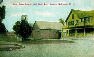
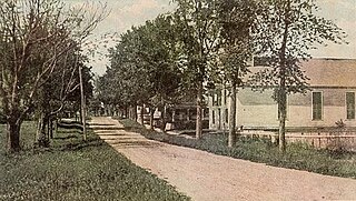
Richmond is a town in Cheshire County, New Hampshire, United States. The population was 1,197 at the 2020 census.

<span class="mw-page-title-main">Rindge, New Hampshire</span> Town in New Hampshire, United States

Rindge is a town in Cheshire County, New Hampshire, United States. The population was 6,476 at the 2020 census, up from 6,014 at the 2010 census. Rindge is home to Franklin Pierce University, the Cathedral of the Pines and part of Annett State Forest.

<span class="mw-page-title-main">Roxbury, New Hampshire</span> Town in New Hampshire, United States

Roxbury is a town in Cheshire County, New Hampshire, United States. The population was 220 at the 2020 census.

<span class="mw-page-title-main">Stoddard, New Hampshire</span> Town in New Hampshire, United States

Stoddard is a town in Cheshire County, New Hampshire, United States. The population was 1,374 at the 2020 census, up from 1,232 at the 2010 census.

<span class="mw-page-title-main">Sullivan, New Hampshire</span> Town in New Hampshire, United States

Sullivan is a town in Cheshire County, New Hampshire, United States. The population was 658 at the 2020 census. It includes the villages of East Sullivan and Ellisville.

<span class="mw-page-title-main">Swanzey, New Hampshire</span> Town in New Hampshire, United States

Swanzey is a town in Cheshire County, New Hampshire, United States. The population was 7,270 at the 2020 census. In addition to the town center, Swanzey includes the villages of East Swanzey, West Swanzey, North Swanzey and Westport.

<span class="mw-page-title-main">Troy, New Hampshire</span> Town in New Hampshire, United States

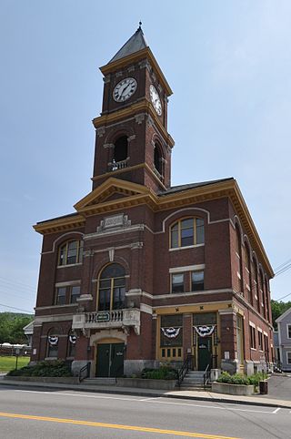
Troy is a town in Cheshire County, New Hampshire, United States. The population was 2,130 at the 2020 census. It is situated west of Mount Monadnock.

<span class="mw-page-title-main">Dummer, New Hampshire</span> Town in New Hampshire, United States

Dummer is a town in Coös County, New Hampshire, United States. The population was 306 at the 2020 census. It is part of the Berlin, NH–VT micropolitan statistical area. Dummer is home to the Pontook Reservoir, popular with canoeists, kayakers and birdwatchers. In the western part of Dummer lies the village of Paris.

<span class="mw-page-title-main">Hinsdale (CDP), New Hampshire</span> Census-designated place in New Hampshire, United States

Hinsdale is a census-designated place (CDP) and the main village in the town of Hinsdale in Cheshire County, New Hampshire, United States. The population of the CDP was 1,485 at the 2020 census, out of 3,948 in the entire town of Hinsdale.

<span class="mw-page-title-main">Hinsdale, New Hampshire</span> Town in New Hampshire, United States

Hinsdale is a town in Cheshire County, New Hampshire, United States. The population was 3,948 at the 2020 census. Hinsdale is home to part of Pisgah State Park in the northeast, and part of Wantastiquet Mountain State Forest in the northwest.

<span class="mw-page-title-main">Jaffrey, New Hampshire</span> Town in New Hampshire, United States

Jaffrey is a town in Cheshire County, New Hampshire, United States. The population was 5,320 at the 2020 census.

<span class="mw-page-title-main">Marlborough, New Hampshire</span> Town in New Hampshire, United States

Marlborough is a town in Cheshire County, New Hampshire, United States. The population was 2,096 at the 2020 census. The town is home to the Kensan-Devan Wildlife Sanctuary at Meetinghouse Pond.

<span class="mw-page-title-main">Winchester (CDP), New Hampshire</span> Census-designated place in New Hampshire, United States

Winchester is a census-designated place (CDP) and the main village in the town of Winchester in Cheshire County, New Hampshire, United States. The population of the CDP was 1,606 at the 2020 census, compared to 4,150 in the entire town.

<span class="mw-page-title-main">Troy (CDP), New Hampshire</span> Census-designated place in New Hampshire, United States

Troy is a census-designated place (CDP) and the main village in the town of Troy in Cheshire County, New Hampshire, United States. The population of the CDP was 1,108 at the 2020 census, compared to 2,130 in the entire town. The center of the CDP is the Troy Village Historic District.

References

  1. 1 2 "2021 U.S. Gazetteer Files – New Hampshire". United States Census Bureau. Retrieved November 5, 2021.
  2. 1 2 3 "Winchester town, Cheshire County, New Hampshire: 2020 DEC Redistricting Data (PL 94-171)". U.S. Census Bureau. Retrieved November 5, 2021.
  3. "2 Equivalent Lands and Fort Dummer". Brattleboro History. Archived from the original on March 17, 2021.
  4. 1 2 Coolidge, Austin J.; John B. Mansfield (1859). A History and Description of New England. Boston, Massachusetts: A.J. Coolidge. pp.  699–700. coolidge mansfield history description new england 1859.
  5. "Winchester Profession". Unitarian Universalist History and Heritage Society. Retrieved October 11, 2011.
  6. History of Winchester, Cheshire County, New Hampshire
  7. "Census of Population and Housing". Census.gov. Retrieved June 4, 2016.
  8. 1 2 3 "Profile of General Population and Housing Characteristics: 2010 Census Summary File 1 (DP-1): Winchester town, Cheshire County, New Hampshire". U.S. Census Bureau, American Factfinder. Archived from the original on February 13, 2020. Retrieved October 27, 2017.
  9. "Selected Economic Characteristics: 2011-2015 American Community Survey 5-Year Estimates (DP03): Winchester town, Cheshire County, New Hampshire". U.S. Census Bureau, American Factfinder. Archived from the original on February 13, 2020. Retrieved October 27, 2017.
  10. "Winchester Proud to present town's pickle festival". New Hampshire Union Leader. Retrieved March 17, 2018.