Troy, New Hampshire

Last updated

Troy, New Hampshire
Town
Troy Meeting House.jpg
Town Hall
Cheshire-Troy-NH.png
Coordinates: 42°49′30″N72°11′01″W / 42.82500°N 72.18361°W / 42.82500; -72.18361
Country United States
State New Hampshire
County Cheshire
Incorporated 1815
Villages
Government
   Board of Selectmen
  • Richard Thackston, Chair
  • Curtis Hopkins
  • TJ Chasse
  Town AdministratorMary Guild
Area
[1]
  Total17.6 sq mi (45.6 km2)
  Land17.5 sq mi (45.2 km2)
  Water0.2 sq mi (0.4 km2)  0.89%
Elevation
1,010 ft (310 m)
Population
 (2020) [2]
  Total2,130
  Density122/sq mi (47.1/km2)
Time zone UTC-5 (Eastern)
  Summer (DST) UTC-4 (Eastern)
ZIP code
03465
Area code 603
FIPS code 33-77380
GNIS feature ID0873740
Website www.troy-nh.us

Troy is a town in Cheshire County, New Hampshire, United States. The population was 2,130 at the 2020 census. [2] It is situated in southwestern New Hampshire, west of Mount Monadnock.

Contents

The town's central village, where 1,108 people resided at the 2020 census, is defined as the Troy census-designated place (CDP), and is located along New Hampshire Route 12. The center of the CDP is listed on the National Register of Historic Places as the Troy Village Historic District.

History

Bird's-eye view c. 1905 Troy, NH and Mount Monadnock.jpg
Bird's-eye view c.1905

Settled in 1762, by 1815 the community had grown so much that it sought its own incorporation. [3] It was set off from Marlborough that year, and included parts of Fitzwilliam, Swanzey and Richmond. A prominent citizen and friend of Governor John Taylor Gilman, Captain Benjamin Mann of Mason, suggested the name "Troy". His daughter, Betsy, was married to Samuel Wilson, famous as "Uncle Sam", and at that time a resident of Troy, New York. At least seven members of Wilson's family were living in the town at the time, thus securing the name. The town hall, built in 1813–1814 near the rail-fenced common, was originally the village meetinghouse. [4]

Troy Mills, which started making horse blankets in the mid-19th century, served as the backbone of the town's economy for nearly 100 years. In 1865, the company was sold by founder Thomas Goodall, who in 1867 would establish Goodall Mills in Sanford, Maine. Troy Mills declared bankruptcy in late 2001 and ceased operations in 2002. The giant mill complex on Monadnock Street now houses two smaller spin-offs of Troy Mills—Knowlton Nonwovens and Cosmopolitan Textiles. The Troy trademark is now used for felt made by a company in West Virginia. Wooden-ware, pottery and fine building stone were also once the products of Troy industries. As of 2024, Troy Mills was being renovated into affordable apartments for low-income families.[ citation needed ]

Geography

According to the United States Census Bureau, the town has a total area of 17.6 square miles (45.6 km2), of which 17.5 square miles (45.2 km2) are land and 0.2 square miles (0.4 km2) are water, comprising 0.89% of the town. [1] Troy is drained by the South Branch of the Ashuelot River and is part of the Connecticut River watershed.

Mt. Monadnock from Perkins Pond causeway on Route 124 Mount Monadnock from route 124.JPG
Mt. Monadnock from Perkins Pond causeway on Route 124

The highest point in town is the south summit of Gap Mountain, at 1,900 feet (580 m) above sea level, near the eastern border. The summit of Mount Monadnock is 2 miles (3 km) northeast of the town in Jaffrey.

Troy is crossed by New Hampshire Route 12 and New Hampshire Route 124. NH 12 passes through the center of town and leads northwest 9 miles (14 km) to Keene and southeast 12 miles (19 km) to Winchendon, Massachusetts, while NH 124, crossing the northeast corner of the town, leads northwest 6 miles (10 km) to the center of Marlborough and east 6 miles (10 km) to the center of Jaffrey.

Adjacent municipalities

Demographics

Historical population
CensusPop.Note
1820 676
1830 6760.0%
1840 6831.0%
1850 75911.1%
1860 7610.3%
1870 7670.8%
1880 7963.8%
1890 99925.5%
1900 1,52752.9%
1910 1,331−12.8%
1920 1,4448.5%
1930 1,267−12.3%
1940 1,3214.3%
1950 1,3603.0%
1960 1,4456.3%
1970 1,71318.5%
1980 2,13124.4%
1990 2,097−1.6%
2000 1,962−6.4%
2010 2,1459.3%
2020 2,130−0.7%
U.S. Decennial Census [2] [5]

As of the census of 2010, there were 2,145 people, 867 households, and 568 families residing in the town. The population density was 123.1 inhabitants per square mile (47.5/km2). There were 932 housing units at an average density of 53.5 per square mile (20.7/km2). The racial makeup of the town was 97.0% White, 0.8% African American, 0.7% Native American, 0.9% Asian, 0.05% some other race, and 0.5% from two or more races. Hispanic or Latino of any race were 1.3% of the population. [6] As of the 2000 census, 18.7% were of American, 13.4% French, 11.8% English, 10.6% Irish, 8.4% French Canadian, 8.2% Finnish and 7.0% Italian ancestry.

At the 2010 census there were 867 households, out of which 31.5% had children under the age of 18 living with them, 49.3% were headed by married couples living together, 11.2% had a female householder with no husband present, and 34.5% were non-families. 26.2% of all households were made up of individuals, and 7.6% were someone living alone who was 65 years of age or older. The average household size was 2.47, and the average family size was 2.96. [6]

In the town, the population was spread out, with 23.1% under the age of 18, 8.1% from 18 to 24, 28.5% from 25 to 44, 29.0% from 45 to 64, and 11.5% who were 65 years of age or older. The median age was 37.8 years. For every 100 females, there were 99.7 males. For every 100 females age 18 and over, there were 97.8 males. [6]

For the period 2010–2014, the estimated median annual income for a household in the town was $55,043, and the median income for a family was $59,750. Male full-time workers had a median income of $45,800 versus $28,359 for females. The per capita income for the town was $29,045. About 4.9% of families and 8.5% of the population were below the poverty line, including 12.6% of those under age 18 and 17.3% of those age 65 or over. [7]

Education

Troy Elementary School Troy elementary.jpg
Troy Elementary School
Monadnock Regional Middle-High School Monadnock High.jpg
Monadnock Regional Middle-High School

Residents of Troy attending public high school go to Troy Elementary school for kindergarten through sixth grade, and Monadnock Regional High School for seventh grade onwards. Both schools are part of the Monadnock Regional School District (SAU93). [8] Troy is the second largest town in the Monadnock Regional School District, the largest being Swanzey. Other towns in the school district are Fitzwilliam, Gilsum, Richmond and Roxbury.

The elementary school is located in Troy, whereas the middle-high school is to the north in the town of Swanzey. Troy School has been educating the children of Troy since 1895 when it was built to house 225 children of all ages. Troy School presently accommodates approximately 135 students in grades K–6. The school day starts at 8:30 AM and ends at 3:10 PM. Students may enter the building at 8:15 AM to have breakfast and get ready for class.

The town of Troy also has two 2015 NH licensed child care facilities with a capacity for up to 75 children.

Notable person

Related Research Articles

<span class="mw-page-title-main">Cheshire County, New Hampshire</span> County in New Hampshire, United States

Cheshire County is a county in the southwestern corner of the U.S. state of New Hampshire. As of the 2020 census, the population was 76,458. Its county seat is the city of Keene. Cheshire was one of the five original counties of New Hampshire, and is named for the county of Cheshire in England. It was organized in 1771 at Keene. Sullivan County was created from the northern portion of Cheshire County in 1827.

<span class="mw-page-title-main">Chesterfield, New Hampshire</span> Town in New Hampshire, United States

Chesterfield is a town in Cheshire County, New Hampshire, United States. The population was 3,552 at the 2020 census. It includes the villages of Spofford and West Chesterfield. Chesterfield is home to Spofford Lake, Chesterfield Gorge Natural Area, and parts of Pisgah State Park and Wantastiquet Mountain State Forest.

<span class="mw-page-title-main">Dublin, New Hampshire</span> Town in New Hampshire, United States

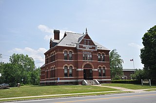
Dublin is a town in Cheshire County, New Hampshire, United States. The population was 1,532 at the 2020 census. It is home to Dublin School and Yankee magazine.

<span class="mw-page-title-main">Fitzwilliam, New Hampshire</span> Town in New Hampshire, United States

Fitzwilliam is a town in Cheshire County, New Hampshire, United States. The population was 2,351 at the 2020 census. Fitzwilliam is home to Rhododendron State Park, a 16-acre (6.5 ha) grove of native rhododendrons that bloom in mid-July.

<span class="mw-page-title-main">Harrisville, New Hampshire</span> Town in New Hampshire, United States

Harrisville is a town in Cheshire County, New Hampshire, United States. Besides the town center, it also includes the villages of Chesham and Eastview. The population of the town was 984 at the 2020 census.

<span class="mw-page-title-main">Nelson, New Hampshire</span> Town in New Hampshire, United States

Nelson is a town in Cheshire County, New Hampshire, United States. The population was 629 at the 2020 census, down from 729 at the 2010 census. Nelson includes the village of Munsonville.

<span class="mw-page-title-main">Richmond, New Hampshire</span> Town in New Hampshire, United States

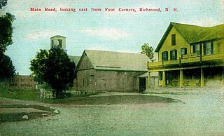
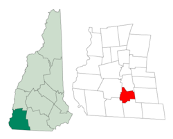
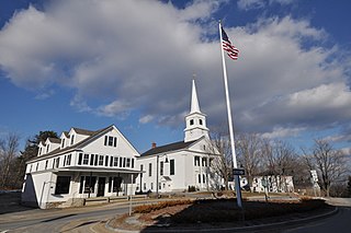
Richmond is a town in Cheshire County, New Hampshire, United States. The population was 1,197 at the 2020 census.

<span class="mw-page-title-main">Rindge, New Hampshire</span> Town in New Hampshire, United States

Rindge is a town in Cheshire County, New Hampshire, United States. The population was 6,476 at the 2020 census, up from 6,014 at the 2010 census. Rindge is home to Franklin Pierce University, the Cathedral of the Pines and part of Annett State Forest.

<span class="mw-page-title-main">Stoddard, New Hampshire</span> Town in New Hampshire, United States

Stoddard is a town in Cheshire County, New Hampshire, United States. The population was 1,374 at the 2020 census, up from 1,232 at the 2010 census.

<span class="mw-page-title-main">Sullivan, New Hampshire</span> Town in New Hampshire, United States

Sullivan is a town in Cheshire County, New Hampshire, United States. The population was 658 at the 2020 census. It includes the villages of East Sullivan and Ellisville.

<span class="mw-page-title-main">Swanzey, New Hampshire</span> Town in New Hampshire, United States

Swanzey is a town in Cheshire County, New Hampshire, United States. The population was 7,270 at the 2020 census. In addition to the town center, Swanzey includes the villages of East Swanzey, West Swanzey, North Swanzey and Westport.

<span class="mw-page-title-main">West Swanzey, New Hampshire</span> Census-designated place in New Hampshire, United States

West Swanzey is a census-designated place (CDP) in the town of Swanzey within Cheshire County, New Hampshire, United States. The population was 1,281 at the 2020 census. It is the largest village in the town of Swanzey.

<span class="mw-page-title-main">Bennington, New Hampshire</span> Town in New Hampshire, United States

Bennington is a town in Hillsborough County, New Hampshire, United States. The population was 1,501 at the 2020 census.

<span class="mw-page-title-main">Greenfield, New Hampshire</span> Town in New Hampshire, United States

Greenfield is a town in Hillsborough County, New Hampshire, United States. The population was 1,716 at the 2020 census. Greenfield is home to the Crotched Mountain Rehabilitation Center, to Greenfield State Park, and to part of the Wapack Trail.

<span class="mw-page-title-main">Milton, New Hampshire</span> Town in New Hampshire, United States

Milton is a town in Strafford County, New Hampshire, United States. The population was 4,482 at the 2020 census. A manufacturing, resort and residential town, Milton includes the village of Milton Mills. The primary village in town, where 593 people resided at the 2020 census, is defined as the Milton census-designated place (CDP), and is located along New Hampshire Route 125 and the Salmon Falls River, just north of Route 75.

<span class="mw-page-title-main">Jaffrey (CDP), New Hampshire</span> Census-designated place in New Hampshire, United States

Jaffrey is a census-designated place (CDP) and the main village in the town of Jaffrey in Cheshire County, New Hampshire, United States. The population of the CDP was 3,058 at the 2020 census, out of 5,320 in the entire town of Jaffrey.

<span class="mw-page-title-main">Jaffrey, New Hampshire</span> Town in New Hampshire, United States

Jaffrey is a town in Cheshire County, New Hampshire, United States. The population was 5,320 at the 2020 census.

<span class="mw-page-title-main">Marlborough, New Hampshire</span> Town in New Hampshire, United States

Marlborough is a town in Cheshire County, New Hampshire, United States. The population was 2,096 at the 2020 census. The town is home to the Kensan-Devan Wildlife Sanctuary at Meetinghouse Pond.

<span class="mw-page-title-main">Winchester, New Hampshire</span> Town in New Hampshire, United States

Winchester is a town in Cheshire County, New Hampshire, United States. The population was 4,150 at the 2020 census. The primary community in the town, where 1,606 people resided at the 2020 census, is defined by the U.S. Census Bureau as the Winchester census-designated place (CDP). The town also includes the village of Ashuelot and part of Pisgah State Park.

<span class="mw-page-title-main">Troy (CDP), New Hampshire</span> Census-designated place in New Hampshire, United States

Troy is a census-designated place (CDP) and the main village in the town of Troy in Cheshire County, New Hampshire, United States. The population of the CDP was 1,108 at the 2020 census, compared to 2,130 in the entire town. The center of the CDP is the Troy Village Historic District.

References

  1. 1 2 "2021 U.S. Gazetteer Files – New Hampshire". United States Census Bureau. Retrieved November 5, 2021.
  2. 1 2 3 "Troy town, Cheshire County, New Hampshire: 2020 DEC Redistricting Data (PL 94-171)". U.S. Census Bureau. Retrieved November 5, 2021.
  3. "Troy, New Hampshire". City-Data.com. Retrieved December 5, 2013.
  4. Coolidge, Austin J.; John B. Mansfield (1859). A History and Description of New England. Boston, Massachusetts: A.J. Coolidge. p.  666. coolidge mansfield history description new england 1859.
  5. "Census of Population and Housing". Census.gov. Retrieved June 4, 2016.
  6. 1 2 3 "Profile of General Population and Housing Characteristics: 2010 Census Summary File 1 (DP-1): Troy town, Cheshire County, New Hampshire". American Factfinder. U.S. Census Bureau. Archived from the original on February 13, 2020. Retrieved January 20, 2016.
  7. "Selected Economic Characteristics: 2010-2014 American Community Survey 5-Year Estimates (DP03): Troy town, Cheshire County, New Hampshire". American Factfinder. U.S. Census Bureau. Archived from the original on February 13, 2020. Retrieved January 20, 2016.
  8. "Monadnock Regional School District". Monadnock Regional School District. Retrieved December 5, 2013.
  9. "EASTMAN, Ira Allen, (1809 - 1881)". Biographical Directory of the United States Congress. Retrieved December 5, 2013.