Sharon, New Hampshire

Last updated

Sharon, New Hampshire
Town
Brick Schoolhouse, Sharon NH.jpg
1832 Schoolhouse
Sharon Town Seal.png
Hillsborough-Sharon-NH.png
Coordinates: 42°48′47″N71°54′56″W / 42.81306°N 71.91556°W / 42.81306; -71.91556
CountryUnited States
State New Hampshire
County Hillsborough
Incorporated 1791
Government
   Board of Selectmen
  • Chet Bowles
  • Diane Callahan
  • Richard Dufresne
  Town AdministratorDebra Harling
Area
[1]
  Total15.7 sq mi (40.6 km2)
  Land15.7 sq mi (40.6 km2)
  Water0.0 sq mi (0.0 km2)
Elevation
1,179 ft (359 m)
Population
 (2020) [2]
  Total359
  Density23/sq mi (8.9/km2)
Time zone UTC−5 (Eastern)
  Summer (DST) UTC−4 (Eastern)
ZIP code
03458
Area code 603
FIPS code 33-68820
GNIS feature ID0873719
Website www.sharonnh.org

Sharon is a town in Hillsborough County, New Hampshire, United States. The population was 359 at the 2020 census. [2] It was the long-time home to the Sharon Arts Center, a nonprofit which has ceased operations.

Contents

History

It was first settled in 1738 as part of "Peterborough Slip", an area which until 1768 included Temple. In 1777, it petitioned to become part of Peterborough, but was denied. It was called "Sliptown" until 1791, when it was incorporated as Sharon. It took its name from Sharon, Connecticut, from which many settlers originated. [3]

The topography is uneven and, in parts, mountainous. In 1823, the population was 400. By 1859, when the population was 229, the town had three sawmills. The principal occupation, however, was farming. [4]

Geography

According to the United States Census Bureau, the town has a total area of 15.7 square miles (40.6 km2), all of it recorded as land. [1] The town is drained by several branches of the Contoocook River, which rise near the southeastern corner of the town. Temple Mountain forms the eastern boundary of Sharon for several miles. Holt Peak on Temple Mountain, at 2,045 feet (623 m) above sea level, is the highest point in Sharon.

Adjacent municipalities

Demographics

Historical population
CensusPop.Note
1790 259
1800 42865.3%
1810 4464.2%
1820 391−12.3%
1830 271−30.7%
1840 251−7.4%
1850 226−10.0%
1860 25010.6%
1870 182−27.2%
1880 20311.5%
1890 137−32.5%
1900 122−10.9%
1910 71−41.8%
1920 21−70.4%
1930 3881.0%
1940 6160.5%
1950 621.6%
1960 7825.8%
1970 13674.4%
1980 18435.3%
1990 29962.5%
2000 36020.4%
2010 352−2.2%
2020 3592.0%
U.S. Decennial Census [2] [5]

As of the census [6] of 2000, there were 360 people, 138 households, and 113 families residing in the town. The population density was 24.7 people per square mile (9.5/km2). There were 159 housing units at an average density of 10.9 per square mile (4.2/km2). The racial makeup of the town was 96.94% White, 0.56% African American, 0.56% Native American, 1.11% Asian, and 0.83% from two or more races. Hispanic or Latino of any race were 0.28% of the population. 24.8% were of English, 17.4% Irish, 6.4% French Canadian, 6.0% Italian, 5.7% Finnish, 5.7% French and 5.4% Polish ancestry according to Census 2000.

There were 138 households, out of which 37.0% had children under the age of 18 living with them, 73.2% were married couples living together, 5.8% had a female householder with no husband present, and 18.1% were non-families. 14.5% of all households were made up of individuals, and 3.6% had someone living alone who was 65 years of age or older. The average household size was 2.61 and the average family size was 2.88.

In the town, the population was spread out, with 24.4% under the age of 18, 5.6% from 18 to 24, 27.5% from 25 to 44, 31.4% from 45 to 64, and 11.1% who were 65 years of age or older. The median age was 41 years. For every 100 females, there were 129.3 males. For every 100 females age 18 and over, there were 117.6 males.

The median income for a household in the town was $66,250, and the median income for a family was $75,325. Males had a median income of $51,071 versus $29,375 for females. The per capita income for the town was $29,478. About 1.8% of families and 3.8% of the population were below the poverty line, including none of those under age 18 and 7.3% of those age 65 or over.

Notable people


Related Research Articles

<span class="mw-page-title-main">Brookfield, New Hampshire</span> Town in New Hampshire, United States

Brookfield is a town in Carroll County, New Hampshire, United States. The population was 755 at the 2020 census.

<span class="mw-page-title-main">Effingham, New Hampshire</span> Town in New Hampshire, United States

Effingham is a town in Carroll County, New Hampshire, United States. At the 2020 census, the town population was 1,691, up from 1,465 at the 2010 census. Effingham includes the villages of Effingham Falls, Effingham, Center Effingham, and South Effingham. Pine River State Forest is in the south.

<span class="mw-page-title-main">Columbia, New Hampshire</span> Town in New Hampshire, United States

Columbia is a town in Coös County, New Hampshire, United States. The population was 659 at the 2020 census, down from 757 at the 2010 census. It is part of the Berlin, NH-VT micropolitan statistical area.

<span class="mw-page-title-main">Alexandria, New Hampshire</span> Town in New Hampshire, United States

Alexandria is a town in Grafton County, New Hampshire, United States. The population was 1,776 at the 2020 census, up from 1,613 at the 2010 census. Newfound Lake is in the northeast corner, with Wellington State Park on the western shore. The town is home to Welton Falls State Forest. Cardigan Mountain State Park, with Mount Cardigan, is in the west. Another attraction is Mowglis Mountain, named for Rudyard Kipling's Jungle Book hero.

<span class="mw-page-title-main">Groton, New Hampshire</span> Town in New Hampshire, United States

Groton is a town in Grafton County, New Hampshire, United States. The population was 569 at the 2020 census.

<span class="mw-page-title-main">Bennington, New Hampshire</span> Town in New Hampshire, United States

Bennington is a town in Hillsborough County, New Hampshire, United States. The population was 1,501 at the 2020 census.

<span class="mw-page-title-main">Brookline, New Hampshire</span> Town in New Hampshire, United States

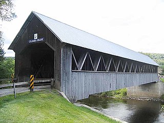
Brookline is a town in Hillsborough County, New Hampshire, United States. The population was 5,639 at the 2020 census, up from 4,991 at the 2010 census. Brookline is home to the Talbot-Taylor Wildlife Sanctuary, Potanipo Pond, and the Brookline Covered Bridge.

<span class="mw-page-title-main">Deering, New Hampshire</span> Town in New Hampshire, United States

Deering is a town in Hillsborough County, New Hampshire, United States. The population was 1,904 at the 2020 census.

<span class="mw-page-title-main">Greenfield, New Hampshire</span> Town in New Hampshire, United States

Greenfield is a town in Hillsborough County, New Hampshire, United States. The population was 1,716 at the 2020 census. Greenfield is home to the Crotched Mountain Rehabilitation Center, to Greenfield State Park, and to part of the Wapack Trail.

<span class="mw-page-title-main">Lyndeborough, New Hampshire</span> Town in New Hampshire, United States

Lyndeborough is a town in Hillsborough County, New Hampshire, United States. The population was 1,702 at the 2020 census.

<span class="mw-page-title-main">Mason, New Hampshire</span> Town in New Hampshire, United States

Mason is a town in Hillsborough County, New Hampshire, United States. The population was 1,448 at the 2020 census. Mason, together with Wilton, is home to Russell-Abbott State Forest.

<span class="mw-page-title-main">Temple, New Hampshire</span> Town in New Hampshire, United States

Temple is a town in Hillsborough County, New Hampshire, United States. The population was 1,382 at the 2020 census. It is home to Temple Mountain State Reservation, formerly the Temple Mountain Ski Area.

<span class="mw-page-title-main">Salisbury, New Hampshire</span> Town in New Hampshire, United States

Salisbury is a town in Merrimack County, New Hampshire, United States. The population was 1,422 at the 2020 census.

<span class="mw-page-title-main">New Durham, New Hampshire</span> Town in New Hampshire, United States

New Durham is a town in Strafford County, New Hampshire, United States. The population was 2,693 at the 2020 census. It is drained by the Merrymeeting, Cocheco and Ela rivers, and is known for Merrymeeting Lake. New Durham is home to the Powder Mill Fish Hatchery, located on Merrymeeting Road. Also located here is the Lions Club's Camp Pride, a camp for children and adults with special needs.

<span class="mw-page-title-main">Sharon, Vermont</span> Town in Vermont, United States

Sharon is a town in Windsor County, Vermont, United States. It had a population of 1,560 at the 2020 census.

<span class="mw-page-title-main">Jaffrey, New Hampshire</span> Town in New Hampshire, United States

Jaffrey is a town in Cheshire County, New Hampshire, United States. The population was 5,320 at the 2020 census.

<span class="mw-page-title-main">Marlborough, New Hampshire</span> Town in New Hampshire, United States

Marlborough is a town in Cheshire County, New Hampshire, United States. The population was 2,096 at the 2020 census. The town is home to the Kensan-Devan Wildlife Sanctuary at Meetinghouse Pond.

<span class="mw-page-title-main">Antrim, New Hampshire</span> Town in New Hampshire, United States

Antrim is a town in Hillsborough County, New Hampshire, United States. The population was 2,651 at the 2020 census. The main village in the town, where 1,395 people lived at the 2020 census, is defined as the Antrim census-designated place (CDP) and is located at the intersection of U.S. Route 202 and New Hampshire Route 31. The town of Antrim also includes the villages of Antrim Center, North Branch, and Clinton Village.

<span class="mw-page-title-main">Greenville, New Hampshire</span> Town in New Hampshire, United States

Greenville is a town in Hillsborough County, New Hampshire, United States. The population was 1,974 at the 2020 census, down from 2,105 at the 2010 census. It is located at the junctions of New Hampshire routes 31, 45, and 123.

<span class="mw-page-title-main">Wilton, New Hampshire</span> Town in New Hampshire, United States

Wilton is a town in Hillsborough County, New Hampshire, United States. The population was 3,896 at the 2020 census. Like many small New England towns, it grew up around water-powered textile mills, but is now a rural bedroom community with some manufacturing and service employment. Wilton is home to the High Mowing School, a private preparatory school.

References

  1. 1 2 "2021 U.S. Gazetteer Files – New Hampshire". United States Census Bureau. Retrieved December 9, 2021.
  2. 1 2 3 "Sharon town, Hillsborough County, New Hampshire: 2020 DEC Redistricting Data (PL 94-171)". U.S. Census Bureau. Retrieved December 9, 2021.
  3. New Hampshire Economic and Labor Market Information Bureau Profile
  4. Coolidge, Austin J.; John B. Mansfield (1859). A History and Description of New England. Boston, Massachusetts: A.J. Coolidge. pp.  647. coolidge mansfield history description new england 1859.
  5. "Census of Population and Housing". Census.gov. Retrieved June 4, 2016.
  6. "U.S. Census website". United States Census Bureau . Retrieved January 31, 2008.