Weare, New Hampshire

Last updated

Weare, New Hampshire
Town
Town Hall, Weare, NH.jpg
Town Hall c.1915
Motto: 
"A Part of Yesterday in Touch with Tomorrow"
Hillsborough-Weare-NH.png
Coordinates: 43°05′41″N71°43′50″W / 43.09472°N 71.73056°W / 43.09472; -71.73056
CountryUnited States
State New Hampshire
County Hillsborough
Incorporated 1764
Named for Meshech Weare
Villages
  • Weare
  • Chase Village
  • Clinton Grove
  • North Weare
  • Riverdale
  • Slab City
  • South Weare
Government
   Board of Selectmen
  • Frederick Hippler, Chair
  • Sherry Burdick
  • Kevin Cahill
  • Benji Knapp
  • Salim Blume
  Town AdministratorNaomi L. Bolton
Area
[1]
  Total60.1 sq mi (155.7 km2)
  Land59.1 sq mi (153.0 km2)
  Water1.0 sq mi (2.7 km2)  1.72%
Elevation
633 ft (193 m)
Population
 (2020) [2]
  Total9,092
  Density154/sq mi (59.4/km2)
Time zone UTC-5 (Eastern)
  Summer (DST) UTC-4 (Eastern)
ZIP code
03281
Area code 603
FIPS code 33-79780
GNIS feature ID0873749
Website www.weare.nh.gov

Weare is a town in Hillsborough County, New Hampshire, United States. The population was 9,092 at the 2020 census. [2] It is close to two important New Hampshire cities, Manchester and Concord.

Contents

History

Piscataquog River in 1912 Piscataquog River, East Weare, NH.jpg
Piscataquog River in 1912

It was granted to veterans of the Canadian wars in 1735 by Governor Jonathan Belcher, who named it "Beverly-Canada" after their hometown, Beverly, Massachusetts. But the charter was ruled invalid because of a prior claim by the Masonian proprietors, who granted 6 square miles (16 km2) as "Hale's Town" to Ichabod Robie in 1749. [3] It was also known as "Robie's Town" or "Weare's Town" before being incorporated by Governor Benning Wentworth in 1764 as Weare, after Meshech Weare, who served as the town's first clerk and later went on to become New Hampshire's first governor. [4]

In 1834, Moses Cartland founded Clinton Grove Academy, the first Quaker seminary in the state. A cousin of John Greenleaf Whittier, Cartland named the village where the school was located "Clinton Grove", in honor of DeWitt Clinton, chief sponsor of the Erie Canal. The original academy served as a private high school. The complex, which included a classroom building, boarding house, barn and sheds, burned in 1872. Classes were then held in the Quaker meetinghouse across the common until 1874, when a new building was completed. [5] It would serve as the Weare school district from 1877 to 1938.

On September 21, 1938, following several days of heavy rain, the New England Hurricane of 1938 passed through the center of New England. The additional rains from the storm caused the Deering Reservoir dam to breach, releasing a wall of water that rushed down to the Weare Reservoir dam. Although the dam held, the flash flood broke through the land at the side of the dam, releasing millions of gallons of reservoir water. The flood washed away everything in its path, leaving parts of Weare devastated. Many active mills were destroyed in the disaster.

In response to the disaster and seasonal flooding, the U.S. Army Corps of Engineers built the 2,000-foot-long (610 m) Everett Dam, as part of the Hopkinton-Everett Flood Control Project, which had been authorized by Congress to prevent a recurrence of the devastating floods. The overall project was completed in 1963 at a total cost of $21,400,000. The dam required the village of East Weare to be permanently abandoned, and formed Everett Lake.

Geography

According to the United States Census Bureau, the town has a total area of 60.1 square miles (155.7 km2), of which 59.1 square miles (153.0 km2) are land and 1.0 square mile (2.7 km2) are water, comprising 1.72% of the town. [1] Weare is drained by the Piscataquog River, which is impounded by Lake Horace in the northwest and by Everett Lake in the northeast. Via the Piscataquog, the town is entirely within the Merrimack River watershed. The three highest summits in Weare form a cluster near the center of town. From south to north, they are Mount Dearborn, at 1,211 feet (369 m) above sea level, Mine Hill 1,211 feet (369 m), and Mount Wallingford, approximately 1,210 feet (370 m).

The town is crossed by New Hampshire Route 77, New Hampshire Route 114 and New Hampshire Route 149.

Adjacent municipalities

Demographics

Historical population
CensusPop.Note
1790 1,924
1800 2,51730.8%
1810 2,6344.6%
1820 2,7815.6%
1830 2,430−12.6%
1840 2,375−2.3%
1850 2,4352.5%
1860 2,310−5.1%
1870 2,092−9.4%
1880 1,829−12.6%
1890 1,550−15.3%
1900 1,5530.2%
1910 1,325−14.7%
1920 1,173−11.5%
1930 1,2879.7%
1940 1,3676.2%
1950 1,345−1.6%
1960 1,4205.6%
1970 1,85130.4%
1980 3,23274.6%
1990 6,19391.6%
2000 7,77625.6%
2010 8,78513.0%
2020 9,0923.5%
U.S. Decennial Census [2] [6]

As of the census [7] of 2000, there were 7,776 people, 2,618 households, and 2,117 families residing in the town. The population density was 132.1 inhabitants per square mile (51.0/km2). There were 2,828 housing units at an average density of 48.1 per square mile (18.6/km2). The racial makeup of the town was 98.25% White, 0.17% African American, 0.22% Native American, 0.42% Asian, 0.22% from other races, and 0.72% from two or more races. Hispanic or Latino of any race were 0.69% of the population.

There were 2,618 households, out of which 48.2% had children under the age of 18 living with them, 71.0% were married couples living together, 5.6% had a female householder with no husband present, and 19.1% were non-families. 13.4% of all households were made up of individuals, and 2.6% had someone living alone who was 65 years of age or older. The average household size was 2.97 and the average family size was 3.28.

In the town, the population was spread out, with 32.0% under the age of 18, 5.7% from 18 to 24, 36.8% from 25 to 44, 20.7% from 45 to 64, and 4.7% who were 65 years of age or older. The median age was 34 years. For every 100 females, there were 101.1 males. For every 100 females age 18 and over, there were 99.5 males.

The median income for a household in the town was $59,924, and the median income for a family was $62,661. Males had a median income of $38,986 versus $27,643 for females. The per capita income for the town was $22,217. About 1.5% of families and 2.5% of the population were below the poverty line, including 1.1% of those under age 18 and 8.2% of those age 65 or over.

Education

Weare has one elementary school, Center Woods Elementary School, serving children in pre-kindergarten through third grade, [8] located on Center Road.

Weare Middle School, located on East Road in Weare center, serves children from fourth grade through eighth grade. [8]

High school students in Weare and Henniker attend John Stark Regional High School.

Notable people

See also

Related Research Articles

<span class="mw-page-title-main">Merrimack County, New Hampshire</span> County in New Hampshire, United States

Merrimack County is a county in the U.S. state of New Hampshire. As of the 2020 Census, the population was 153,808, making it the third most populous county in New Hampshire. Its county seat is Concord, the state capital. The county was organized in 1823 from parts of Hillsborough and Rockingham counties, and is named for the Merrimack River. Merrimack County comprises the Concord, NH Micropolitan Statistical Area, which in turn constitutes a portion of the Boston–Worcester–Providence, MA–RI–NH–CT Combined Statistical Area. In 2010, the center of population of New Hampshire was located in Merrimack County, in the town of Pembroke.

<span class="mw-page-title-main">Hillsborough County, New Hampshire</span> County in New Hampshire, United States

Hillsborough County is the most populous county in the U.S. state of New Hampshire. As of the 2020 census, the population was 422,937, almost one-third the population of the entire state. Its county seats are Manchester and Nashua, the state's two biggest cities. Hillsborough is northern New England's most populous county as well as its most densely populated.

<span class="mw-page-title-main">Deering, New Hampshire</span> Town in New Hampshire, United States

Deering is a town in Hillsborough County, New Hampshire, United States. The population was 1,904 at the 2020 census.

<span class="mw-page-title-main">Francestown, New Hampshire</span> Town in New Hampshire, United States

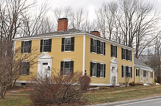
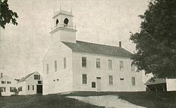
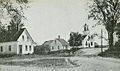
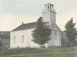
Francestown is a town in Hillsborough County, New Hampshire, United States. The population was 1,610 at the 2020 census. The village of Francestown, population 201 in 2020, is in the center of the town.

<span class="mw-page-title-main">Goffstown, New Hampshire</span> Town in New Hampshire, United States

Goffstown is a town in Hillsborough County, New Hampshire, United States. The population was 18,577 at the 2020 census. The compact center of town, where 3,366 people resided at the 2020 census, is defined by the U.S. Census Bureau as the Goffstown census-designated place and is located at the junctions of New Hampshire routes 114 and 13. Goffstown also includes the villages of Grasmere and Pinardville. The town is home to Saint Anselm College, the Goffstown Giant Pumpkin Regatta, and was the location of the New Hampshire State Prison for Women, prior to the prison's relocation to Concord in 2018.

<span class="mw-page-title-main">Greenfield, New Hampshire</span> Town in New Hampshire, United States

Greenfield is a town in Hillsborough County, New Hampshire, United States. The population was 1,716 at the 2020 census. Greenfield is home to the Crotched Mountain Rehabilitation Center, to Greenfield State Park, and to part of the Wapack Trail.

<span class="mw-page-title-main">Lyndeborough, New Hampshire</span> Town in New Hampshire, United States

Lyndeborough is a town in Hillsborough County, New Hampshire, United States. The population was 1,702 at the 2020 census.

<span class="mw-page-title-main">New Boston, New Hampshire</span> Town in New Hampshire, United States

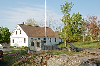
New Boston is a town in Hillsborough County, New Hampshire, United States. The population was 6,108 at the 2020 census, up from 5,321 at the 2010 census. New Boston is home to the annual Hillsborough County Agricultural Fair and the Molly Stark Cannon. The 1743 cannon, which appears on the town seal, was given by General John Stark to the New Boston Artillery Company after the Battle of Bennington.

<span class="mw-page-title-main">Pinardville, New Hampshire</span> Census-designated place in New Hampshire, United States

Pinardville is a census-designated place (CDP) in the town of Goffstown, Hillsborough County, New Hampshire, United States. It is a suburban neighborhood adjacent to the city of Manchester. The population was 5,034 at the 2020 census. Pinardville has existed since 1906.

<span class="mw-page-title-main">Contoocook, New Hampshire</span> Census-designated place in New Hampshire, United States

Contoocook is a village and census-designated place (CDP) within the town of Hopkinton in Merrimack County, New Hampshire, United States. The population was 1,427 at the 2020 census. Contoocook is well known for its growth of small businesses, preservation of historical landmarks, community involvement and recreational activities within the village.

<span class="mw-page-title-main">Dunbarton, New Hampshire</span> Town in New Hampshire, United States

Dunbarton is a town in Merrimack County, New Hampshire, United States. The population was 3,005 at the 2020 census, up from 2,758 at the 2010 census.

<span class="mw-page-title-main">Hopkinton, New Hampshire</span> Town in New Hampshire, United States

Hopkinton is a town in Merrimack County, New Hampshire, United States. The population was 5,914 at the 2020 census. The town has three distinct communities: Hopkinton village, mainly a residential area in the center of the town; Contoocook, the town's business hub, located in the north; and West Hopkinton, within the more agricultural portion of the town. The town is home to the Hopkinton State Fair, adjacent to Contoocook village, and to the historic Contoocook Railroad Depot and the Contoocook Railroad Bridge, the oldest covered railroad bridge in the United States.

<span class="mw-page-title-main">Hillsborough (CDP), New Hampshire</span> Census-designated place in New Hampshire, United States

Hillsborough is a census-designated place (CDP) and the main village in the town of Hillsborough in Hillsborough County, New Hampshire, United States. The population of the CDP was 2,156 at the 2020 census, out of 5,939 in the entire town.

<span class="mw-page-title-main">Henniker (CDP), New Hampshire</span> Census-designated place in New Hampshire, United States

Henniker is a census-designated place (CDP) and the main village in the town of Henniker in Merrimack County, New Hampshire, United States. The population of the CDP was 3,166 at the 2020 census, out of 6,185 in the entire town. The CDP is the home to New England College.

<span class="mw-page-title-main">Henniker, New Hampshire</span> Town in New Hampshire, United States

Henniker is a town in Merrimack County, New Hampshire, United States. As of the 2020 census, the reported total population of the town was 6,185, although the figure, 27.9% greater than the 2010 population, has been questioned by local officials. Henniker is home to New England College and Pats Peak Ski Area. Henniker is a college town and resort area, featuring both skiing and white-water kayaking.

<span class="mw-page-title-main">Hillsborough, New Hampshire</span> Town in New Hampshire, United States

Hillsborough, frequently spelled Hillsboro, is a town in Hillsborough County, New Hampshire, United States. The population was 5,939 at the 2020 census. The town is home to Fox State Forest and part of Low State Forest.

<span class="mw-page-title-main">Piscataquog River</span> River in New Hampshire, United States

The Piscataquog River is a 34.7-mile-long (55.8 km) river located in southern New Hampshire in the United States. It is a tributary of the Merrimack River, which flows to the Gulf of Maine.

<span class="mw-page-title-main">West Hopkinton, New Hampshire</span> Populated place in New Hampshire, United States

West Hopkinton is a populated place within the town of Hopkinton in Merrimack County, New Hampshire, United States. West Hopkinton is well known for its agricultural center, preservation of historical landmarks and recreational activities within the village.

<span class="mw-page-title-main">Goffstown (CDP), New Hampshire</span> Census-designated place in New Hampshire, United States

Goffstown is a census-designated place (CDP) and the main village in the town of Goffstown in Hillsborough County, New Hampshire, United States. The population of the CDP was 3,366 at the 2020 census, out of 18,577 in the entire town.

<span class="mw-page-title-main">New Boston (CDP), New Hampshire</span> Census-designated place in New Hampshire, United States

New Boston is a census-designated place (CDP) comprising the main village in the town of New Boston, Hillsborough County, New Hampshire, United States. As of the 2020 census, the population of the CDP was 326, out of 6,108 in the entire town.

References

  1. 1 2 "2021 U.S. Gazetteer Files – New Hampshire". United States Census Bureau. Retrieved December 10, 2021.
  2. 1 2 3 "Weare town, Hillsborough County, New Hampshire: 2020 DEC Redistricting Data (PL 94-171)". U.S. Census Bureau. Retrieved December 10, 2021.
  3. Warren Brown, Volume 1 of History of Hampton Falls, N.H. Rumford Press, 1900.
  4. Austin J. Coolidge & John B. Mansfield, A History and Description of New England; Boston, Massachusetts 1859
  5. History of Weare, Hillsborough County, New Hampshire; J.W. Lewis & Company, Philadelphia 1885
  6. "Census of Population and Housing". Census.gov. Retrieved June 4, 2016.
  7. "U.S. Census website". United States Census Bureau . Retrieved January 31, 2008.
  8. 1 2 "Student and Parent Handbook, 2022-2023". Weare School District. June 15, 2022. Retrieved January 10, 2023.